

SouthCoastMA
-
Posts
6,423 -
Joined
-
Last visited
Content Type
Profiles
Blogs
Forums
American Weather
Media Demo
Store
Gallery
Posts posted by SouthCoastMA
-
-
That energy from Ontario is a bit too late but precariously close to making that a much bigger storm.
-
The ICON track is sick. Only problem is it's all rain

-
10 minutes ago, weatherwiz said:
What a disturbing trend this thread has taken the past few pages.
What a shame...if only
Oh so close. It's something to track, and possibly the 2nd to last winter threat of the year..so no one should be shamed for being up at 2:45 AM to check a model
-
1 minute ago, RUNNAWAYICEBERG said:
This never had a chance. Best shot is going bowling early next week with a better airmass.
Well I still think theres a very small chance..but gonna have to see those changes shortly. But yeah seems like a better shot next week
-
A storm like what the 12z/18z FV3 GFS had yesterday is what we'd need to get snow down here. Maybe theres room to still get back there..but best shot looks to be in Maine now
-
59 minutes ago, TauntonBlizzard2013 said:
The para gfs from the last few days is the only way we’ll get significant snow from this down here. More ways than not to fail this time of year south of the pike.
Unless it fits into a perfect window, it’s nothing or rain here. I’d keep an eye on it though. Can’t hurt
Yeah it needs to develop a lot sooner for us to score. Still a few days out so worth an eye
-
Def some good hits in there. The GEFS had a few as well. Would be nice to start seeing a few non-FV3 OP runs start biting.
-
Fv3 Jacks me with 26". Gotta be correct
-
5 minutes ago, CoastalWx said:
Not dead but on support.
Anything past day 6 or 7 is always on support anyway
-
About 75/25 snow/sleet
-
That must be a typo
-
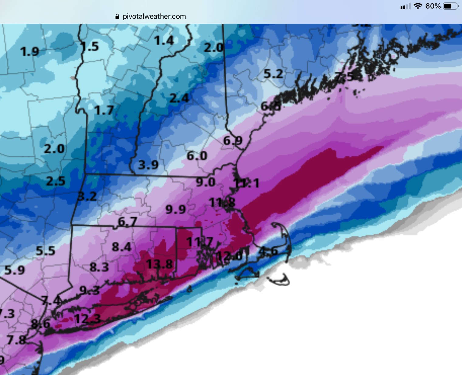
It's compacted to about 4" or 4.5" of waterlogged cement now after it rained/sleeted around 4am. Went out around 2am and it was a solid 5.5-6" before it changed over. Roads are mostly wet though. Glad I didn't have to drive to Foxboro today for a meeting where the roads must be a lot worse
-
It thumped pretty good here before the mixing started. Prob around 6" of paste. Congrats to those further north though
-
6 minutes ago, Baroclinic Zone said:
All over itself

Yeah dont think I'm getting a foot but nice to look at
-
Snowing lightly. Expecting 3 or 4" before sleet
-
6 minutes ago, #NoPoles said:
I think this storm is going to be rain for me. Usually when the models have the rain line in my general area, im on the rain side of it. I think Scooter could Jack on this one!
You are going to get snow for the first several hours regardless of changeover.
-
Craziest rates for me that I can recall are late night Jan 22 05 in Wareham (the band that Falmouth reported 8" in one hour) and probably the early morning of Feb 15 2015 in Acushnet.
Was the Euro any warmer down here or did it not really matter?
-
2 minutes ago, ORH_wxman said:
Yeah the models tend to have a Bias of painting the best qpf where the max low level forcing is...and sometimes those on the southeast side of the max model qpf actually get dryslotted pretty bad. The best midlevel forcing tends to be a bit underdone....that region near BOS out to ORH and back to central CT looks prime.
So true. I've been in jack qpf map zones enough to know this first hand..even when no taint is involved
-
4 minutes ago, rnaude241 said:
Not expecting much in PYM, maybe 2-4. I think we flip to rain to quickly.
Models have been trending a bit colder..you could be just far enough north. I'd say 4"-6"+ is something achievable
-
1 minute ago, Damage In Tolland said:
I think far SE Mass to Cc to S Ri may end up flipping to sleet which some of that there is. Nam gives that area several hours of sleet . Maybe even GON
Its likely going to flip here but should be a good thump nevertheless
-
Man that RPM blows here..but really goes nuts from Taunton northward
-
It really is a quick mover..by the time it changes over here...theres like 1-2 hours of precip left
-
Just now, tiger_deF said:
Let's all hope for a northwestward trend in the 00z suite of the GFS
knowing my predictions and the season the it's gonna have the low off of Florida isn't it...
Let's all not..but feel free.
I'm surprised I'm not at least under a watch, given the hellacious dump before any change to rain here.
-
Decent storm. 4" of paste in a winter like this is a Win in my opinion
March Disco
in New England
Posted
The airmass blows but it can be overcome, that's the point. It's not far off at the moment, at 96 hours out. plenty of time to improve (or get worse).