

mimillman
-
Posts
3,468 -
Joined
-
Last visited
Content Type
Profiles
Blogs
Forums
American Weather
Media Demo
Store
Gallery
Posts posted by mimillman
-
-
7 minutes ago, cyclone77 said:
That graphic that showed a 90% chance at 18" there kind of cracked me up. A 90% chance at a 4" for northern IL would be like winning the lottery at this point lol.
You can’t even point to climo at this point. It’s just blind luck
-
4 minutes ago, hardypalmguy said:
not happening this year
Hah, watch. Trust me I’d rather it didn’t
-
 1
1
-
-
MSP will know how we feel in 3-5 years

-
 1
1
-
-
Ready for 15 degrees below normal in April and frequent RN/SN mix
-
 2
2
-
3
-
-
8 hours ago, A-L-E-K said:
i'm sure we have a couple banger winters left in the tank here in chicago before i croak, learning to embrace our new texas climo as i age tho
Idk how much of it is new climo vs a decade of sh*t. They’ve happened before and they’ll happen again.
-
18 hours ago, RCNYILWX said:
I grew up most passionate about snowstorms since I came from NYC where the big snowstorms are some of the most interesting weather they get. But I've grown to not get as bothered by not getting as much snow and to appreciate these mild days in the winter.
If you love snow, I get it, this has been a bad winter for that across most of northern IL and even worse south of here. On the other hand, relentlessly cold and snowy winters, while memorable, are just a lot to deal with. For it to be uncomfortable being outside for seemingly months on end during the darkest time of year can get depressing. Plus it's not much fun driving on crap road conditions.
I still love big snowstorms, enjoy when we do have snow otg and make sure to take my kids out sledding, but I think days like today are a good part of our winter variability and a reason to be okay with these milder winters. Def wouldn't be happy living in a beavis climate.
Having experienced some periods of bitterly cold to extreme cold weather while living out here, unless it's historic, pass. Give me a few good snowstorms, some periods of sustained snow cover, but less deep cold and a decent helping of mild days, I'm all set.
Sent from my SM-G998U using Tapatalk
Ricky moving to Dallas imminently
-
1
-
-
Geez is this winter horrendously bad
-
3
-
1
-
-
Poor dendrite quality but it is coming down at good pace and it’s extremely windy. Just walked the dog and is pretty brutal out there
-
LE will be saving grace here to maybe get to an inch
-
Snowy run on the 606. Lake enhancement whitening surfaces ahead of defo
-
4
-
-
Came home to wicker and we have SN here. Ground is very slippery
-
Heavy rain
-
1
-
-
RN- downtown
-
1
-
-
1 hour ago, CheeselandSkies said:
Surprising to me how down to the wire 2011-'12 was in terms of just sneaking into the below 20" list. It's the only one in my adult life that really stands out in my memory as an effectively snowless winter. Of course as we've seen, with so many events having sharp cutoffs in totals, even in a generally unproductive winter for the entire region, the perception of the season for someone in, say, Madison can be dramatically different compared to someone in Chicago.
Actually I was flying home today and went right over Dubuque / Beloit / Rockford. I was sitting on the north facing side of the plane flying east. I couldn’t believe how thin the cold sector was from the storm last week. I could see the entirety of it from my window, west to east. Pathetic
-
1
-
-
As long as we get top 10 futility I’m happy. Would be nice to beat 2011-2012
-
1
-
1
-
-
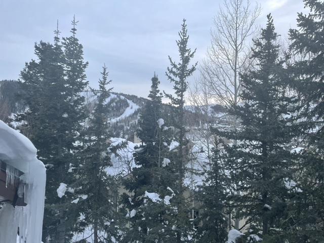
Back to Chicago today after a week skiing in Utah.
Out to LA on Friday for the long weekend.
Annual UP snowmobile trip first weekend of March.
Fine with the torch as long as the trails are good up north. Most depressing winter I’ve seen for Chicago and New York. Let it be done
-
Time for some fun. 6-10” tomorrow.
-
4
-
 1
1
-
-
Don’t be so down, I’m sure we’ll have some great cold shots in April!
-
1
-
1
-
-
On 1/22/2023 at 4:36 PM, A-L-E-K said:
Let's go

-
1
-
-
4 hours ago, Hoosier said:
As we close in on February, I'd have to say that this is about the most pathetic winter I've ever seen in this area up to this point. I've lived in a few different locations so let's just say the years I've been living around the I-80 corridor. Still have not had the grass fully covered yet. The December storm might have done it if there hadn't been so much blowing/drifting, but hard to say. Still haven't had a 3" snowfall. Not to go all beavis on ya but that is just ridiculous for this latitude.
It’s felt like winter only twice this season:
1) The 72 hours after the Christmas storm
2) Now
This is the most pathetic winter I’ve seen, hands down.
-
29 minutes ago, Hoosier said:
2011-12 finished with 19.8", which was the lowest total for Chicago since 1948-49
Bring it, it would be nice to close out this winter with a top 10 lowest snowfall
-
23 minutes ago, Hoosier said:
Was curious so I checked. Here's a fun fact. ORD snowfall through 1/28
2011-12: 13.7"
2022-23: 13.6"
Yea and it didn’t get better
-
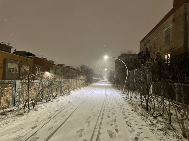
Quiet Sunday morning in wicker park. Eyeballing about 1.5” here. Side roads aren’t treated. Scene looks similar to Christmas Eve.
I’m off to Deer Valley for a week starting next Saturday so let it torch.
-
2
-
-
Looks like some big dog futility records being broken in the northeast:
JFK: Warmest January on record
JFK and Central Park today will tie (and look to easily shatter) latest first measurable snowfall.
-
1
-
1
-
1
-
February 21-23 Major Winter Storm
in Lakes/Ohio Valley
Posted
36 degrees and 1-2” of rain is just about as miserable as it can get eh