stormtracker
-
Posts
64,391 -
Joined
-
Last visited
Content Type
Profiles
Blogs
Forums
American Weather
Media Demo
Store
Gallery
Everything posted by stormtracker
-
It's deflating, but imma hang in there till 0z, including 18z later when the GFS hilariously does a full cave in 6 hours. Our model really does suck ass.
-
I guess you can put it that way. For the fish.
-
Well out to sea. Hits no one substantially
-
Yup..she's out. Toss the fucking GFS
-
Not looking good yall. Sorry
-
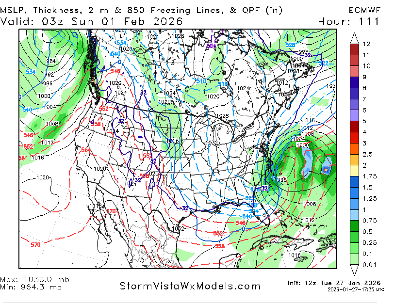
ok...our surface low is about to get going in the gulf. I see a slight difference..flow is backed just a smidge bit vs 6z, but nothing to get excited about sadly. Altho the closed low on the surface maps is a bit wester
-
A lil separation of that s/w energy where the block is, but that's about it and pretty minute
-
57. Absolutely no change at h5
-
Correct
-
I have to keep switching back to make sure I actually have the 6z up because 12z looks exactly like it so far. 36h
-
Not one change on the Euro so far. Carbon copy. Of course, it's early yet...
-
Well, starting now through Sat, good thing is...this'll be an instant death on the models. Money panels would come in in like 15 mins or less
-
Well sorta. Was dogshit on QPF, but those thermals can't be beat. Lesson learned when the NAM throwing thermal red flags.
-
Here we go. May the odds be in our favor. Euro has begun
-
I'm not high on it either, but I'm sticking around. Hope level is highly dependent on the Euro. Which is going to let us down as it always does.
-
Now watch we have the GFS as the only model in our camp. I hope not, because it'll just lead us on to hang on longer than we should. Come on Euro......if ever we needed you
-
I'd lock that mfer up right now and wouldn't gamble.
-
Wait, GFS is back???
-
Harsh, but fair. This is what i do when I’m out. I’ll just say I’m out and just stop posting.
-
About 2,450 of them
-
I’m shocked he thinks this.
-
The 84 hour NAM didn’t really look that bad tbh I’ll be stuck on metro. Red line is delayed and everything else is a debacle. Next pbp won’t be til the 12z Euro when it shows our blizzard hitting us
-
But seriously, it looks bleak. But I'm hanging in there for a bit. The chances of a comeback dwindle with each new set of runs at this point and I hate to say this, I get the gloom in here, but I think we should slow down and give it another run or two.
-

-
See yall in the AM!