
Moonhowl
-
Posts
648 -
Joined
-
Last visited
Content Type
Profiles
Blogs
Forums
American Weather
Media Demo
Store
Gallery
Posts posted by Moonhowl
-
-
3 hours ago, Met1985 said:
Yeah September has been the month.
Let's hope this September isn't a roaster like last year.
-
 1
1
-
-
I can't get the bear poop in my yard to dry out so I can remove it

-
23 hours ago, nrgjeff said:
Apparently the FF guidance is low there. WPC has flood risk.
On the bright side somewhat fall-ish weather is on deck after the front. Watching the Perseid(s) the other night (only one, lol) I noticed Orion coming up in the East. Orion is of course a staple of the winter evening sky. He's like, hold on, fall and winter are on the way!
Hopefully more snow will grace the Mountains this winter, though it'll be a chore with La Nina. Ski areas need our support more than ever. I'd say if not bar hopping at night, it's safe to ski/ride bundled up with face coverings anyway. Get take-out to support restaurants.
Never too early to think ahead, lol!

I went out on the back forty about 4 am Wednesday morning and saw over 20 meteors which was nice; sorry you missed the show.
I plan to hit the slopes this winter; per usual I try to go at the least crowded times possible (early and late season) so social distancing should not be much of a problem. Always nice to think about skiing instead of how hot it has been at times. Looking forward to some cooler weather

Yes Met1985, a rainy day; just started pouring at the house while I was writing this.

-
1
-
-
Got over 2 inches of rain in about 30 minutes this evening and a flooded basement.
-
1
-
-
5 hours ago, Met1985 said:
7th straight day of rainfall already...
Maybe try growing rice in the garden next year?

-
 3
3
-
-
Even though MBY went through a dry stretch there were still storms in the area. Sans just a few days, there has been at least the threat of rain everyday throughout the entire summer.
-
1
-
-
1 hour ago, Buckethead said:
So I start out this morning at 0729 with a lightning strike that took out my modem and router and knocked out power and knocked down two 80' chestnuts.
That was probably the most intense electrical storm I've seen up here. The hailstorm we had last month was tamer than this.
Sent from my SM-G970U using Tapatalk
Holy cow, I had no idea there were storms in the area until I looked at the radar at about 10:30 am (I took the pictures at 6:51 am). The power of storms is always fascinating to see but the damage sucks.
Have since had some light rain here but nothing like what you had.
-
1
-
-
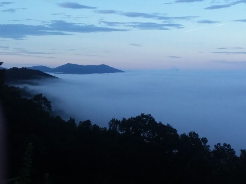
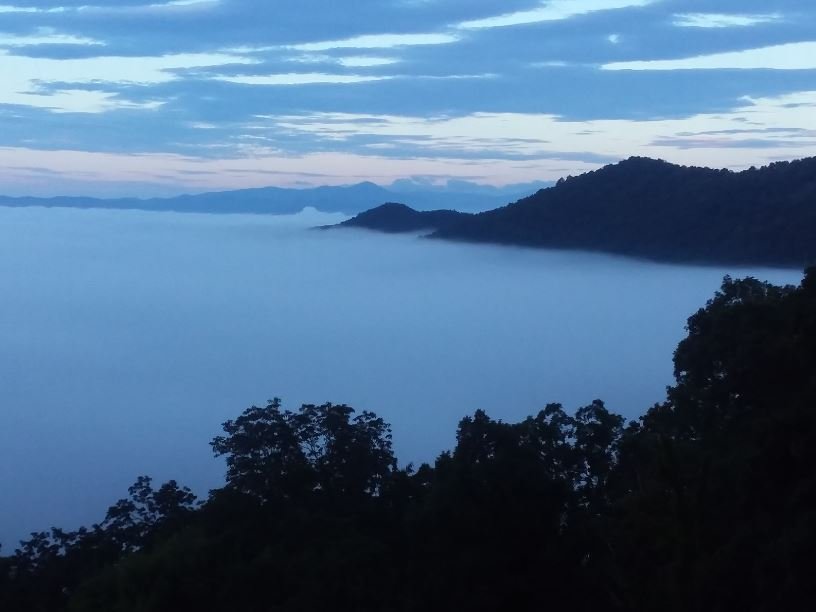
Was nice to finally get a tiny bit of rain yesterday which contributed to the inversion valley fog this morning. Attached a few pictures from a sunrise bicycle ride on the Parkway this morning:
-
2
-
-
16 hours ago, Buckethead said:
I haven't had a drop of rain at my house in over a week now. Storms all around almost daily, but nothing.
Sent from my SM-G970U using Tapatalk
Same here, had lightning within 1/4 mile of the house but no more than a few drops of rain.
-
1
-
-
Looking at the GFS it appears the next cool down is courtesy of air getting funneled down here from Hudson Bay, unbelievable on the ways air from the north ends up IMBY this spring.
-
2
-
-
1 hour ago, Sw NC weather said:
Looks like we’re heading towards a cooler and wet pattern next week.
I believe this is what Met1985 was alluding to in is comment about the Euro 10 days ago. The models have accurately sniffed out the cut-off lows well in advance in recent months.
-
1
-
-
10 hours ago, Met1985 said:
Looking at the EURO and the GFS, it looks unsettled and another decent cool shot down the road.
I had wanted to do some back country camping now that the USFS is allowing it in many places but ain't going in the rain. Looks like the 2.5 months of March we had has also resulted in an extended monsoon season.
-
1
-
-
14 minutes ago, Met1985 said:
What a raw and nasty morning. Reminds me of early November.
Mother nature has issued a stay inside order

-
1
-
-
A mere 1.8" IMBY at the moment with light rain.
-
1
-
-
1 hour ago, WintersNotComing said:
I'll be waking up EARLY to try to get there for the sunrise. Looks to be a good spot at the moment. I'd love to camp but I know there's no way I can talk my girlfriend into that...
I love it when WintersNotComing is coming to where winterwillnotgoaway. You and Eyewall have a great trip and have fun! I will be sitting this one out by the wood-stove this evening.
-
3
-
-
9 hours ago, Hvward said:
I slipped on ice on my deck this morning. I am currently over May. Frosted at my house this morning... 2200’ and a mile from the French Broad. My thermometer said 31.
This spring we are getting 2.5 months of March and last fall we got 2.5 months of August; these transition seasons have been failing on the transition part.
-
1
-
-
5 hours ago, Met1985 said:
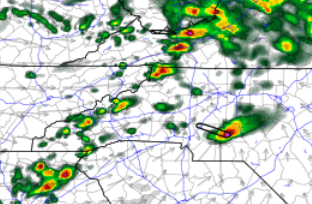
Some heavy rainfall and storms moving through tonight. I thought we were getting dry....
Luckily got very little of that last night but the Upstate can't catch a break. We will see if a cell hits this afternoon; HRR indicates some potential:
-
1
-
-
12 hours ago, Buckethead said:
Down to 34.8° with a wintry mix in Wolf.
Sent from my SM-G970U using Tapatalk
From the looks of the GFS you have more to look forward to this month.
-
1
-
-
12 hours ago, wncsnow said:
Models hinting at another pretty strong trough and cold shot late next week. Euro has more high elevation snow and could be more widespread frost.
Yes, the east cost trough returns; when this happens in May I always start reminiscing about May 1992, first time I ever went cross country skiing; found this in the Los Angeles Times of all places:
https://www.latimes.com/archives/la-xpm-1992-05-10-mn-2323-story.html
-
1
-
 1
1
-
-
Appear to be bottoming out about 37 F here in the valley. Looking forward to the warm up today and brief break from the wind.
-
1
-
-
18 hours ago, Met1985 said:
The 12z GFS is still advertising snow for around the 26th and the 27th. The main thing is there is a big signal for another significant trough in the east. Actually the next two weeks the trough in the east just reloads for us... Where was this at this winter?!
It would be nice to get this setup before March; best of my recollection winter of 2010-2011 was the last time we had the teleconnections set up well during the winter; however, when it ended in February, spring ended up being early and warm in 2011 (based on my unreliable memory). The 2009-2010 winter was epic.
Anyway, in the month of April, l I don't need to look at the models. Just glance here and if I see you posting, then I know Dogwood winter is upon us

-
1
-
-
Enjoy this coming Wednesday because this may be the only time this happens for the next couple of weeks (if this holds true); NAM agrees:
NWS GSP forecast for Avl:

Emphasis on "Calm"
-
1
-
-
4 hours ago, Met1985 said:
Both the GFS and the Euro are still showing a major cool down starting tomorrow and then an even bigger cool down around the 14th. The GFS is deeper and more stable with the trough in the east. Im hedging in the GFS side because recently it has done better with the medium range than the Euro. But we are going to see temps some 15 to 20 degrees below normal around the area and maybe a chance for some high elevation snows.
Yes, we are passed due for our annual killing freeze; you would think the plants would know by now that it happens every year

-
1
-
-
7 minutes ago, Met1985 said:
Heavy rain yesterday evening with Thunderstorms and heavy rain overnight. Over 2 inches from the past 2 days. We just cant seem to dry out... Looking down the road the Euro still shows a decent trough getting in here around the 2nd and the GFS is picking this up finally. Looks like a rain to snow event then upslope snow for a bit. We will see if this holds but I think it will.
Guess winter will end up being November and April
-
1
-
2020 Spring and Summer mountain thread.
in Southeastern States
Posted
GFS has it going right over us; last thing we need is tropical rain since it already seems we live in a tropical rainforest and I'm not even in Transylvania County.