TheMainer
-
Posts
304 -
Joined
-
Last visited
Content Type
Profiles
Blogs
Forums
American Weather
Media Demo
Store
Gallery
Everything posted by TheMainer
-
Ice Ice Baby December 28-29 Storm Discussion
TheMainer replied to Baroclinic Zone's topic in New England
Wife said we topped out at 2 inches new snow at the house and from her pics a few mins ago the rain hasn't even melted that yet in the driveway, so hoping this ends up a net gain. Another good band of rain to roll through it looks like then hopefully a Dryslot. Not sure we've lost much snow at all here at the office in Auburn since I got here at 8am. -
Ice Ice Baby December 28-29 Storm Discussion
TheMainer replied to Baroclinic Zone's topic in New England
Freezing drizzle and 29 in Waterville, Maine, assuming we're going to lose our all snow shortly back at the house -
Ice Ice Baby December 28-29 Storm Discussion
TheMainer replied to Baroclinic Zone's topic in New England
20 F and snow leaving the house on the way to Auburn area, should be an exciting drive... 1.1" of snow, hope we can hang on longer to snow like some of the Hi-res stuff is showing. -
Ice Ice Baby December 28-29 Storm Discussion
TheMainer replied to Baroclinic Zone's topic in New England
CAR is going with 2-4 here, up to an inch of sleet, and possibly 0.25 of freezing rain. I just hope by the time the rain gets here around 3-4pm we can Dryslot. Went and cut and packed our trails all open again today with the new snow after last Friday's wind and rain, honestly we're ready to groom, just need to have a bit of a net gain, even an inch or two would be huge -
Ice Ice Baby December 28-29 Storm Discussion
TheMainer replied to Baroclinic Zone's topic in New England
Models are all spitting out 3-5 inches of snow north of the 45th in our area, fingers crossed that's right, but still worried about the warm layer coming up quick to flip to freezing rain. Hopefully Tolland, CT gets 0.5 and we stay mostly snow and sleet! -
I'm hoping for 3-5 inches of snow/sleet before the flip to freezing rain and we'd be mint. However I think it's going to be more like 1-2
-
Around 1.5 inches new snow this morning, still -sn this morning, very festive!
-
Hoping we save it up here, NWS seems confident in all snow for our neck of the woods but the models look ugly outside the ensembles.
-
White Christmas Miracle? December 23-24th
TheMainer replied to Baroclinic Zone's topic in New England
Almost 8.5 inches at the lake, we snuck over 6 inches as it's still -sn, best guess with compaction about 6.5 in the valley here.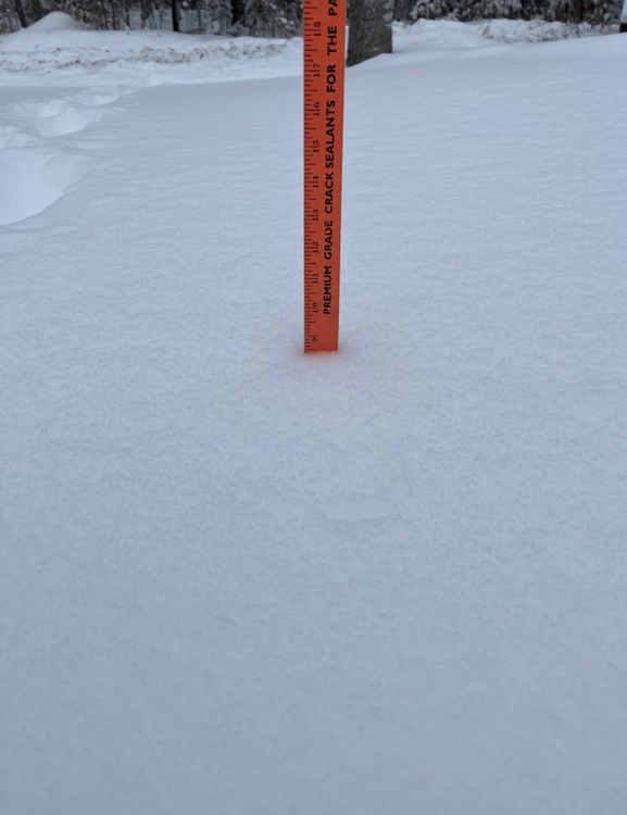
-
White Christmas Miracle? December 23-24th
TheMainer replied to Baroclinic Zone's topic in New England
Radar looks thin but still nice steady large flakes, groomer barn measuring 7 inches. Fire ripping, home made cinnamon rolls from the wife for breakfast, life is good! -
Id take the 0z Euro run just as currently modeled for Sunday and NYD, but hopefully it'll shift south a bit to get many others in on it too.
-
White Christmas Miracle? December 23-24th
TheMainer replied to Baroclinic Zone's topic in New England
5.75" here and -Sn, radar looks paltry, but maybe we squeeze 6 inches. Id say at least 12:1 ratios. Congratulations Dryslot, glad I don't have to drive to KLEW area today! -
White Christmas Miracle? December 23-24th
TheMainer replied to Baroclinic Zone's topic in New England
-
White Christmas Miracle? December 23-24th
TheMainer replied to Baroclinic Zone's topic in New England
Expecting 3-4 inches, but hoping for 6! If we can pull Sunday off too we'll be firing up the groomers before the new year which would be the first in over 5 years -
White Christmas Miracle? December 23-24th
TheMainer replied to Baroclinic Zone's topic in New England
I'll take my 3-5 inches and let the southern Maine guys have the fun, I think we're in a slightly better position as things play out in the longer term -
Feels like a weaker 2023, also on a Friday, also our company Christmas party, also rain and wind. Pack is definitely taking a big bit on Dryslot land, hoping when I return home around 7pm I have a few inch pack left that will turn into a glacier tomorrow
-
Nice 50 mile ride from the house today, trails were actually pretty decent, another 6 inches and they would have been perfect, oh well, I'd be surprised we had any snow Saturday morning, the bullseye is right over our heads ..

-
I'm praying for a 18z GFS scenario, almost all other guidance has us well over 1 inch of QPF. Maybe it'll have a clue. We can survive 0.75, our snow is light and fluffy and will compact and we'd be back in business with another 6-8 inches. Riding from the house tomorrow afternoon for a quick 70 mile loop with some buddies in case Friday goes real sour.
-
Euro with over 1.5 inches of QPF over my head the last two runs for Friday...
-
Fingers crossed CAR has the right idea in their AFD Rainfall amounts of one half to one inch are most likely, with a small chance of local amounts to around 1.5 inches. Significant snowpack loss is expected Downeast, with less snowpack loss and more compaction for central and northern areas. The snowpack will absorb most of the rainfall, so flooding is not a significant concern. The low level jet will also produce strong to possibly damaging winds, especially along the coast. Further inland, cold snowpack should act to strengthen the surface inversion and limit mixing towards the surface.
-
I had no doubt it was coming even up here, right now looks like the weenie 1 inch QPF band will be directly over our heads, hopefully we can trend that down to 0.5 inches and our pack will be intact come Saturday.
-
If I never saw 0.25 or more of ice again it'd be too soon cause I'm the guy who has to go clear our trail system after, 98 was pure devastation up here, you can keep that all south of the Pike as far as I'm concerned
-
Looking at the Euro and GFS runs we'd be right on the line of wintery and rainy even way up here, but overall not terrible. Looks like all the events will be close so plenty of time to trend those all south a bit to get everyone else in on the game.
-
Little over 4 inches at the house when I got back from the snowmobile club meeting, closing in on 6 inches at the groomer barn, I don't expect much snow tonight but maybe the radar will fill back in.
-
About 3 inches down and snowing at a good clip, half way to my Wish-cast of 6".