

JC-CT
-
Posts
17,866 -
Joined
-
Last visited
Content Type
Profiles
Blogs
Forums
American Weather
Media Demo
Store
Gallery
Posts posted by JC-CT
-
-
1 minute ago, ORH_wxman said:
Hard to tell on the crappy black and white maps, but rgem looks a bit better at 18z too.
better for eastern mass, kind of the same elsewhere in SNE
-
1 minute ago, Ginx snewx said:
that half hour of subsidence might cost her a tenth of an inch in qpf which in the next couple of frames she gets 1 inch in 5 hrs
exactly lol
icon is definitely west of 12z based on total qpf maps on stormvista
-
Just now, #NoPoles said:
Ouch, that is some UGLY subsidence!!! And it's over my fanny
lol, you do ok...
-
2 minutes ago, dendrite said:
Well the satellite has different bands with different wavelengths that measure wv at different levels. I think the rule of thumb was that the more typically used wv images showed you wv around the 600mb level. I haven’t gotten enough into GOES-R to know what micrometer wavelengths they use for their lower, mid, and upper wv maps. I think the mid trop one is 6.9um. Plus there’s the fact you’re comparing vorticity to water vapor. I’m just not sure I would be hyperscrutinizing the two looking for comparisons or model error.
Ok thanks. bun me!
-
Just now, Ginx snewx said:
Lol why would you quit, that's pretty dumb
good point as well
-
1 minute ago, RUNNAWAYICEBERG said:
If I get a foot Kev and JC has been adamant about, I’ll quit the board.
I've been adamant that you aren't out of the game for the mid level magic. Not adamant that you will definitely end up in a 25 mile wide band.
-
3 minutes ago, Ginx snewx said:
part of the equation
The SPC runs a comprehensive surface objective analysis scheme called SFCOA. The system runs at the top of each hour, using the latest 40km RAP forecast grids as a first guess. Next, the surface data is merged with the latest RAP forecast/analysis upper-air data to represent a 3-dimensional current objective analysis. Finally, each gridpoint is post-processed with a sounding analysis routine called NSHARP to calculate many technical diagnostic fields related to severe storms.
Thanks steve
-
Just now, Ginx snewx said:
Queen
hypocritical queen at that lol
-
Just now, Ginx snewx said:
Yes Mesoanalysis is how you compare
always thought that was just a RAP prog
-
-
1 minute ago, RUNNAWAYICEBERG said:
See nothing wrong there, in fact it looks better for you clowns out east. Slower and wants to stall. Congrats.
The death band from hell is right over your head
-
 1
1
-
-
-
20 minutes ago, dendrite said:
Be careful comparing WV to modeled H5 vorticity...it isn’t totally apples to apples.
Appreciate the guidance, would you mind explaining a bit?
-
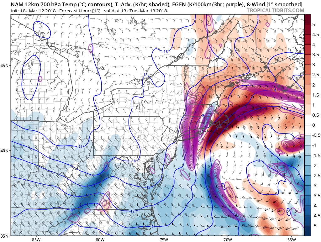
4 minutes ago, JC-CT said:
There is that kicker in the northern stream that is still NW of lake winnipeg that models will not have a good handle on. It seems like that one is coming in pretty hot and accelerating the northern stream.
Looks at least a couple hours ahead of the 12z NAM's schedule
-
There is that kicker in the northern stream that is still NW of lake winnipeg that models will not have a good handle on. It seems like that one is coming in pretty hot and accelerating the northern stream.
-
11 minutes ago, dryslot said:
Man does that look awesome.
That northern stream just seems to be booking so fast, like twice the speed of the southern stream. Sure looks like it's gonna catch up.
I dunno. Models > the human eye.
-
1 minute ago, Chrisrotary12 said:
The northern stream vort has essentially caught the southern stream one......feel like I need one of Tip's head spinning posts about what this means.
we need to see if they make love or make war
-
Just now, Typhoon Tip said:
I'm actually wondering (a little) about this doing an about face and coming all the way in and whacking New NJ to NYC too with ...
Fact of the matter is, this run is a whopper correction toward more phasing, even if it only upped the QPF some and brought things more confidently to the I-95 corridor of eastern sections ... it is the 2nd trip in that regard for a trend that started last night and may yet end up on the 00z being the fuller phase this whole verkokte set up really should be heading for when based upon conventional wisdom..
But "as is" aside... the trend in its self shows that even at 24 to 30 hours out this thing is not stable -
That, combined with water vapor imagery that sure as heck seems to show that northern s/w digging hard, yeah I won't be surprised with adjustments continuing, albeit in smaller form.
-
3 minutes ago, WintersComing said:
Ryan just tweeted he is bumping totals!!
lol

-
Big difference starting around hour 33
-
The Euro won't buck the h5 trend here. Partial phasing by hour 6
-
9 minutes ago, HIPPYVALLEY said:
The deeper and more wound up this ends up probably means a slight cut in QPF in WNE as precip shield tightens?
It usually works like that, but not sure this time it applies because the wound up solutions are due to phasing.
-
1 minute ago, OceanStWx said:
There’s always a bit of a caution flag, because models do a pretty poor job of handling ridge building ahead of East Coast cyclogenesis.
It’s why the NW trend sometimes seems like it won’t be denied.
convection to the south of me, vortmaxes to the north, here I am, stuck in the middle with you
-
1
-
-
1 minute ago, Chrisrotary12 said:
Is it just me or is the northern stream vort a lot further southwest of where it's modeled to be?
I think so too, models are definitely struggling with it.
March 13th ... west Atlantic bombogenesis type low clipping SE New England, more certain ...may be expanding inland
in New England
Posted
ryan broadbrushed the state 6-12, i think it's a decent move