JC-CT
-
Posts
18,191 -
Joined
-
Last visited
Content Type
Profiles
Blogs
Forums
American Weather
Media Demo
Store
Gallery
Everything posted by JC-CT
-
Active mid December with multiple event potential
JC-CT replied to Typhoon Tip's topic in New England
Well they think a good SNE snowstorm is the same as a great lakes cutter. To them it is. -
Active mid December with multiple event potential
JC-CT replied to Typhoon Tip's topic in New England
yeah -
Active mid December with multiple event potential
JC-CT replied to Typhoon Tip's topic in New England
yeah not sure what's up with that. Route 2, I could see being concerned. -
Active mid December with multiple event potential
JC-CT replied to Typhoon Tip's topic in New England
It always seems like the GFS overdoes it with that. -
Active mid December with multiple event potential
JC-CT replied to Typhoon Tip's topic in New England
It's a stretched low as shown on all the OP runs, so those ones just have the "lowest" low already out east. But I'm sure those members are elongated/double barrel -
Active mid December with multiple event potential
JC-CT replied to Typhoon Tip's topic in New England
borderline marxist -
Active mid December with multiple event potential
JC-CT replied to Typhoon Tip's topic in New England
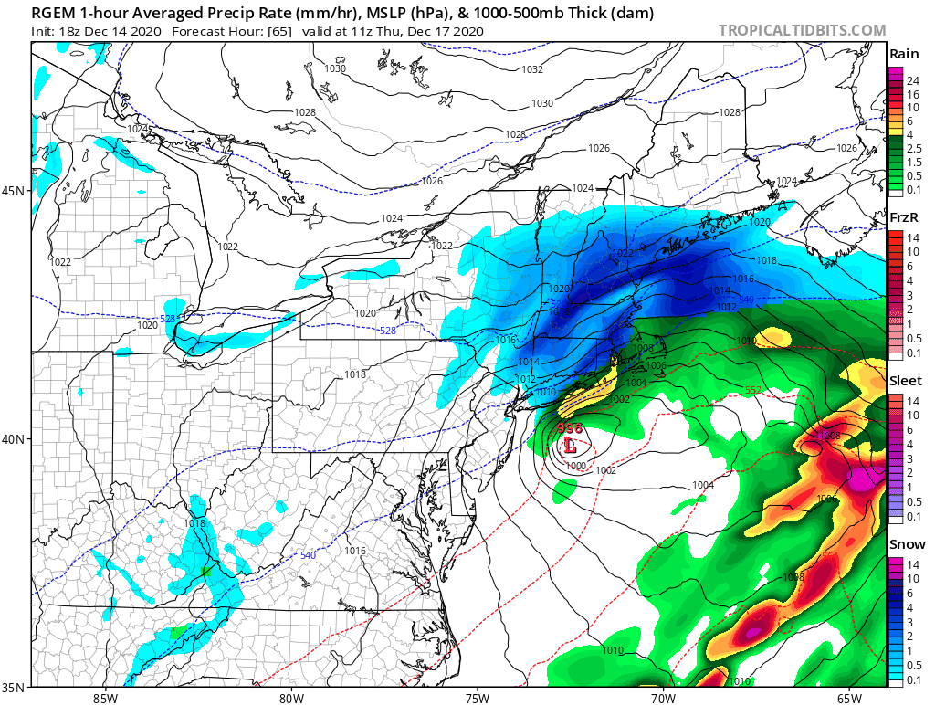
It actually carries the same dryslot all the way out into the gulf of maine. I really think it was just a function of the rgem's particular evolution this run. If it verified, ooph for several of us.
-
Active mid December with multiple event potential
JC-CT replied to Typhoon Tip's topic in New England
the GEFS definitely trying to work their way back nw -
Active mid December with multiple event potential
JC-CT replied to Typhoon Tip's topic in New England
It looked more to me like a subsidence zone that more or less stays in the same place after the initial banding push, due to the trajectory of the storm. -
Active mid December with multiple event potential
JC-CT replied to Typhoon Tip's topic in New England
Lol thank you, I literally just figured out my mistake. But I think he's like 5 miles west. -
Active mid December with multiple event potential
JC-CT replied to Typhoon Tip's topic in New England
I guess from the surface to 1000mb isn't very thick at that particular moment, eh -
Active mid December with multiple event potential
JC-CT replied to Typhoon Tip's topic in New England
Thanks, this is a learning opportunity for me - so 35F at the surface and above freezing through 1000 isn't going to be a problem? -
Active mid December with multiple event potential
JC-CT replied to Typhoon Tip's topic in New England
1" QPF line running almost due E-W through approx Keene/Manchester -
Active mid December with multiple event potential
JC-CT replied to Typhoon Tip's topic in New England
the cutoff for the goods is right around the MA north border -
Active mid December with multiple event potential
JC-CT replied to Typhoon Tip's topic in New England
Looks a bit warm, isn't he pretty far out on the cape, out by the elbow? -
Active mid December with multiple event potential
JC-CT replied to Typhoon Tip's topic in New England
Yeah exactly what I was thinking. It was always going to correct back south, but the majority of SNE will love this run's result. -
It's finally snowing here as the back edge approaches, just never really got enough precipitation.
-
Active mid December with multiple event potential
JC-CT replied to Typhoon Tip's topic in New England
Shot! -
Active mid December with multiple event potential
JC-CT replied to Typhoon Tip's topic in New England
Okay, sorry my nonexistent meteorology degree isn't from an ivy league school, or even worse, that it is from Brown. So you are saying that the kicker wasn't there 4 days ago on the GFS, and now it is there on the GFS, and that's why the GFS is currently 100 miles south of some other guidance. I will have to mull this over. -
Active mid December with multiple event potential
JC-CT replied to Typhoon Tip's topic in New England
I was just saying that the existence of that feature doesn't explain the GFS' handling of cyclogenesis compared to other models that are further north. I agree that look from the 12/10 06z run was more dynamic, but it also resulted verbatim in a rainstorm east of 91. -
Active mid December with multiple event potential
JC-CT replied to Typhoon Tip's topic in New England
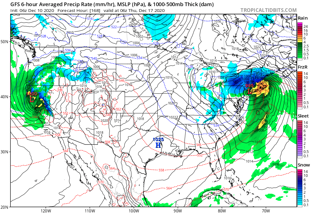
Nevermind I see the fuzzy 6 now... 12/10 06z GFS
-
Active mid December with multiple event potential
JC-CT replied to Typhoon Tip's topic in New England
Yeah but look at the CMC - it's even stronger. -
Active mid December with multiple event potential
JC-CT replied to Typhoon Tip's topic in New England
Is it always a full day behind? -
Active mid December with multiple event potential
JC-CT replied to Typhoon Tip's topic in New England
oh snap so it is -
Active mid December with multiple event potential
JC-CT replied to Typhoon Tip's topic in New England
tropical tidbits has it