

wxman
-
Posts
723 -
Joined
-
Last visited
Content Type
Profiles
Blogs
Forums
American Weather
Media Demo
Store
Gallery
Posts posted by wxman
-
-
2 minutes ago, winterwarlock said:
I am here in Belle Mead and the rates while picked up over the last hour are nothing to write home about moderate type rates....we have about an inch down...got half inch in the past hour
It's snowing like a beast. I see it and radar confirms it. Just blasted over 2". Maybe you live in a microclimate.
-
1 minute ago, NJwx85 said:
Not what I'm seeing. Crushing snow right now and the radar is juiced.
-
Pouring snow as of now, 1.5" down. temp 23
-
5 minutes ago, DCTeacherman said:
Grew up in nyc area, came up from the dc area and visiting my parents in Yorktown. Radar looks amazing!!
Enjoy, I like reading your posts in your sub forum.
-
1" down. 23 degrees.
-
 2
2
-
-
Moderate snow, everything but roads (treated) now covered. Temp 26/DP 21
-
3 minutes ago, wdrag said:
No time to rereview... I see 0z/6 EC likes a colder scenario near I95. Could happen. The se edge still has to have sleet convert to snow which is incorrect but NYC and I95... I'm uncertain and I dont have all the tools NWS does. Please follow NWS. Appended 06z/16 EC 10 to 1. It says I'm a bit too far nw on my NYS expectations. Use your judgement. Thanks... offline til at least 930A. You'll know by then whether 12z 3K NAM has trended colder nr NYC. To me one bad sign... too much sun 6-8 hrs before an event starts. The classics have a long slow process of thickening and lowering cigs. This tells me an 8 hour front end thump down here then maybe sleet starts I80 LI midnight-2a. Have fun with this. Walt 744A

Love, you Walt, and your a pros pro, of course.....but "To me one bad sign... too much sun 6-8 hrs before an event starts. The classics have a long slow process of thickening and lowering cigs." I mean, really? That sounds like something I might say, LOL. In any event, clouds are lowering and thickening here. Best of luck to all!
-
 1
1
-
-
23 minutes ago, SnoSki14 said:
I heard 06Z Euro looked really good.
Yup. 13-16+ all of NJ from Raritan bay north.
-
1
-
-
Don't worry about dire predictions for the rest of this winter. Last year some of the best and brightest were predicting an epic winter, and we know how that turned out. In these parts very hard to tell what will happen. The stars have to align no matter the overall pattern, and when they do they do. I think that unpredictability and scarcity fuels the obsession.
-
It seems to me the sleet on the NAM (at least the 3K) is dependent on lighter precip/dry slotting. If we can keep that at bay we can tack on a few more inches. Still time for even more improvements.
-
2
-
-
Just now, Northof78 said:
Maybe and hour or so of sleet/mix in the city, rest is snow...on what used to be the warmest/west model...excellent trend for the model over past 3-4 runs.
I'd say more like 2-3 hrs sleet as depicted, but still moving in the right direction.
-
3 minutes ago, NEG NAO said:
yes for the last 10 years on here start reading this: and before that on EasternWeather
NYC/PHL: December 24-27th Potential - New York City Metro - American Weather (americanwx.com)
LOL, and before eastern those message boards. Getting old my friend, but not too old for good times!
-
Doesn't this happen almost every storm? And, yet, we forget.
-
3
-
-
One more tick SE and it will be the storm we had been expecting. Not impossible at all.
-
5
-
-
Looks like euro is 10 plus for most of the forum except immediate coast, LOL, now watch it be wrong. Not the king it used to be.
-
5 minutes ago, JoshSnow said:
That snow map looks almost exactly like January 23rd 2016.
I got 23.5" in that one. I think even Southern NJ joined that party, 13.4" at AC airport. This depiction is further north and not as heavy anywhere.
-
1
-
-
2 minutes ago, CPcantmeasuresnow said:
No thanks.
I'll take the snow with less wind and keep my power. Nothing worse than sitting through a blizzard in a dark cold house.
I'll take a no power blizzard over full power but no storm.
-
2 minutes ago, Rjay said:
Oof
Looks pretty extreme. Baltimore gets nothing?
-
I know this sounds ridiculous (because it is) but over the years I've noticed a few things. First, in the good winters it "just wants to snow." This week's system was a good example. In "bad years" this would have been a nonevent. This year it snowed all day and put down a nice coating. Maybe this is a good omen for next week, right up there with my observation that the best storms get the snow going quicker than anticipated...and the unforeseen delay in the start often spells doom.
-
Snowing lightly but nicely at 34 degrees.
-
2
-
-
moderate snow here. Ground turning white. Temp 35.
-
1
-
-
1.6" final total here.
-
First flakes here at 24.6 degrees.
-
2" final here.

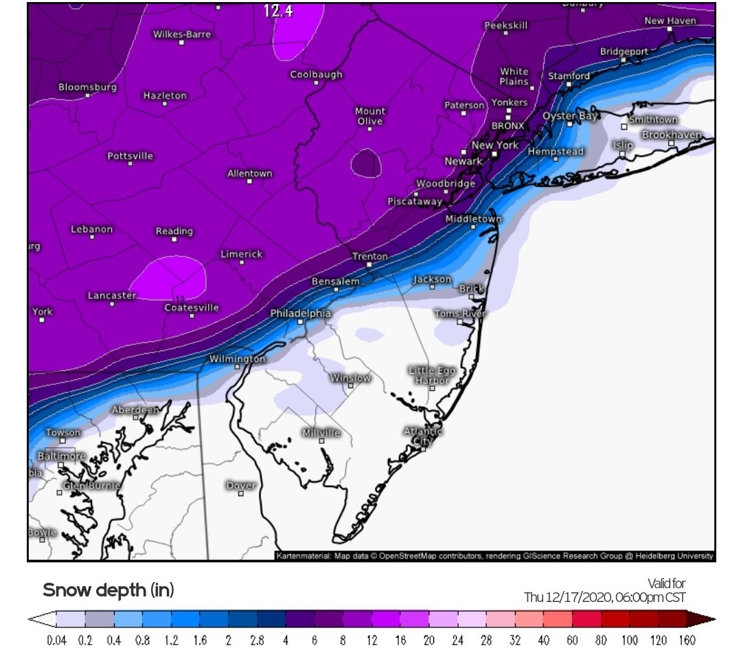
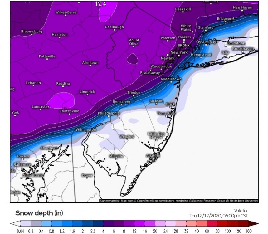
Major Nor'easter snow storm (possible top 20) Noon Wednesday-Noon Thursday Dec 16-17, 2020
in New York City Metro
Posted
Between 3-1/2 and 4-1/2". Hard to measure with the blowing. temp steady at 23.