

wxman
-
Posts
723 -
Joined
-
Last visited
Content Type
Profiles
Blogs
Forums
American Weather
Media Demo
Store
Gallery
Posts posted by wxman
-
-
10 minutes ago, EastonSN+ said:
That would be a nasty I've event NYC through LI.
Here would be snow but right on edge.
850s are colder earlier, would not be prolonged or accreting ice in my experience with this set up, some of that is snow.
-
 1
1
-
-
2 minutes ago, Rjay said:
Snow nw
.thumb.png.cd604071ac5e062a4aaea8a9790f750c.png)
.thumb.png.bf7bd5175fb289fb5cd6f4538ef343b8.png)

Looks colder at 850 in the earlier panels based on my quick look, way out there anyway.
-
 1
1
-
-
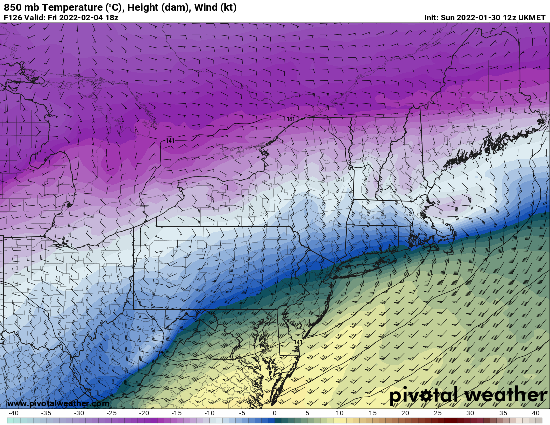
43 minutes ago, HVSnowLover said:
Trend toward Euro on 12Z GFS for the late week storm.
12Z UKMET is good for 9" on Friday in the metro area.
-
2
-
1
-
 1
1
-
-
4.75" at 9:13am. Temp. 19.
-
2.25" down. 25 degrees. Moderate snow.
-
1
-
-
1.5" down. Temp 26.6
-
Where's Walt?
-
4
-
-
Steady light snow with a coating down. Let's keep this going!!!
-
1
-
-
pixie dust and 27 degrees
-
1
-
-
3 minutes ago, leesburg 04 said:
At least one model will give me 2" tonight
Reminds me of a funny line on easternwx back in the day at 2am, "we're looking at the wrong "models""
-
1
-
1
-
-
Is there a control run on the euro 18z?
-
When has this ever been easy?
-
It used to be that the euro was rock solid while the others were like blind squirrels, doesn't seem that way these days.
-
1 minute ago, mappy said:
THIS
2 minutes ago, clskinsfan said:Its not a disaster for us nw folks. I knew what a storm like this means for us. We need to maximize the front end. Then watch the precip go poof as the coastal bombs. It is just how it is for us. Any snow is good snow. And think of it like this. If you weren't a weather weenie you would have no idea OC is getting a foot while you get 2 inches. You would just he happy with the 2 inches you got.
...says the wife.........
-
1
-
-
The classic, "just when you thought you were out they suck you back in." Darn euro!
-
1
-
1
-
-
2' with 30" lollies, LOL!!
-
1
-
-
If the euro is THAT wrong it would be among it's biggest busts this close in to my memory at least. But it's on it's own right now.
-
Just now, SnoSki14 said:
Don't pay attention to the surface. H5 is considerably different than last couple runs with a strong trend towards Euro.
Well, for my part of NJ the GFS is 2" or so while the euro is 2 feet or so.
-
1
-
-
2 minutes ago, MJO812 said:

As I mentioned, this output is just like the 06Z euro control run....which as I read it uses the non-perturbed ensemble members and best available data. That being said, in my experience tracking east coast storms the control does not come close to the operational in terms of what actually occurs when they diverge, have no idea why. In this case they match.
-
Looks like the end result is similar to the 06z control in our area.
-
I remember, below is from my archive, mind you we ended with about 5" backlash, and lucky to get even that (sorry for the poor format)!
...WINTER STORM WATCH FOR THE PERIOD BEGINNING SUNDAY AFTERNOON AND
CONTINUING THROUGH AT LEAST MONDAY EVENING...
THE APPROACHING STORM HAS THE POTENTIAL TO DEVELOP BLIZZARD
CONDITIONS WITH VERY HEAVY SNOWFALL AND STRONG WINDS. PREPARATIONSSHOULD BE TAKEN IMMEDIATELY.
TRAVEL WILL BECOME VERY DIFFICULT AND DANGEROUS...IF NOT
IMPOSSIBLE...BEGINNING LATE SUNDAY AND CONTINUING INTO THE EARLY
PART OF THE NEW WEEK. IF YOU MUST TRAVEL...DO IT BEFORE SUNDAYAFTERNOON OR EXPECT TO WAIT UNTIL MID WEEK.
THE NATIONAL WEATHER SERVICE HAS CONTINUED THE WINTER STORM WATCH
THAT BEGINS ON SUNDAY AFTERNOON. THE WATCH AREA INCLUDES...BUT ISNOT LIMITED TO...THE FOLLOWING REGIONS.
- EASTERN PENNSYLVANIA...FROM THE POCONOS DOWN THROUGH THE
PHILADELPHIA METROPOLITAN AREA.- NORTHWESTERN...CENTRAL AND SOUTHERN NEW JERSEY.
- THE ENTIRE STATE OF DELAWARE.
- NORTHEASTERN MARYLAND.
LOW PRESSURE...CENTERED NEAR NEW ORLEANS EARLY THIS AFTERNOON...WILL
MOVE SLOWLY TO THE NORTHEAST. THE LOW IS FORECAST TO MOVE OFF OFTHE MID ATLANTIC COAST AROUND THE VIRGINIA CAPES ON MONDAY MORNING.
THE STORM IS THEN EXPECTED TO INTENSIFY AS IT REMAINS OVER THE
COASTAL WATERS OF THE MID ATLANTIC REGION ON MONDAY AND TUESDAY.THE STORM IS ANTICIPATED TO FINALLY BEGIN TO MOVE OUT TO SEA ON
TUESDAY NIGHT AND WEDNESDAY.
THE STRONG...SLOW MOVING STORM IS FORECAST TO BRING VERY HEAVY SNOW
TO THE WATCH AREA AND TO SURROUNDING REGIONS BEGINNING ON SUNDAY
AFTERNOON AND PERHAPS CONTINUING INTO TUESDAY. WHEN ALL IS SAID ANDDONE...SNOWFALL TOTALS OF ONE TO TWO FEET WILL BE COMMON THROUGHOUT
THE REGION.
STRONG WINDS WILL ALSO ACCOMPANY THE STORM...RESULTING IN BLOWING
ND DRIFTING OF SNOW. VISIBILITIES WILL BE REDUCED TO NEAR ZERODURING MUCH OF THE STORM.
ON SUNDAY...THE PRECIPITATION IS FORECAST TO SPREAD INTO NORTHEAST
MARYLAND...DELAWARE AND EXTREME SOUTHERN NEW JERSEY BY DAYBREAK. ATTHAT POINT IT SHOULD BE MAINLY IN THE FORM OF RAIN. BY MID DAY...THEPRECIPITATION WILL LIKELY HAVE SPREAD UP ABOUT AS FAR AS
PHILADELPHIA AND TOMS RIVER...IN THE FORM OF SNOW. MEANWHILE...THERAIN IN AREAS TO THE SOUTH SHOULD ALSO BEGIN TO CHANGE TO SNOW.
DURING THE BALANCE OF SUNDAY AFTERNOON...THE SNOW WILL SPREAD UP
INTO THE LEHIGH VALLEY...THE POCONOS AND NORTHERN NEW JERSEY.
-
1
-
-
-
.5" final here. Looks pretty though. 29.
-
.png.cebf8878114152308e5ceb8c5ba4525e.png)
.png.733b8c7ef88602e3c5195101c1a2a2b7.png)

Late January and February Medium/Long Range Discussion
in Mid Atlantic
Posted
LOL, I did the same thing, and then there was the faux wood radio shack cube, always trying to get into contorted positions to pull in the distant stations...and waiting for those sacred words..."an area of low pressure will move northeast from the gulf, reforming over Cape Hatteras," we knew what that meant! Cheers