mitchnick
-
Posts
28,735 -
Joined
About mitchnick

-
2026-2027 Super El Nino
mitchnick replied to Stormchaserchuck1's topic in Weather Forecasting and Discussion
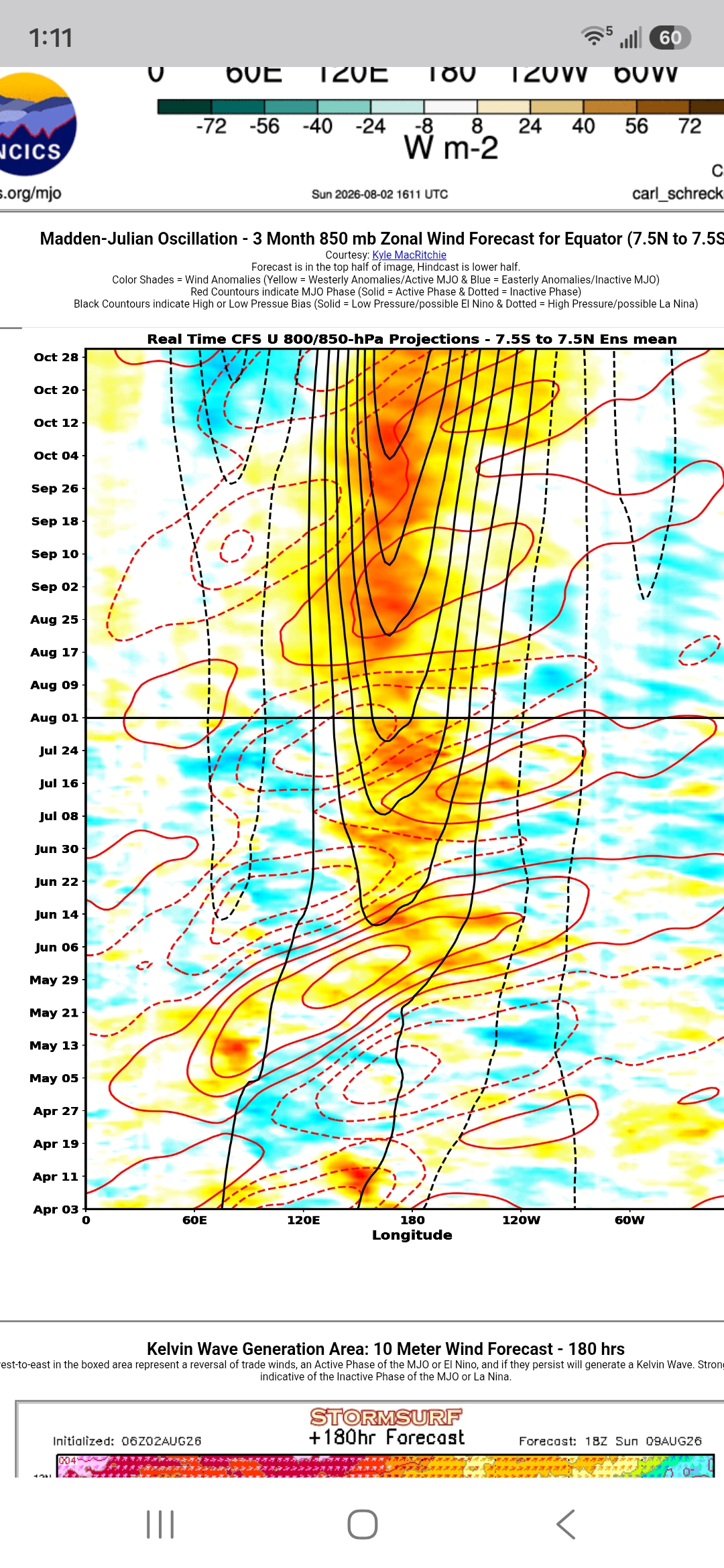
Yet, and this may have already been mentioned, most modeling shows the upcoming MJO having an affinity for the Maritime Continent. https://www.stormsurf.com/page2/links/mjo_phase.html -
2026-2027 Super El Nino
mitchnick replied to Stormchaserchuck1's topic in Weather Forecasting and Discussion
Cfs2 has been hitting hard in October for a while. Considering how far away we are from October, it might be the biggest yet if correct. But is that signaling the big finale? Idk. Just wondering based on an apparent November forecast peak.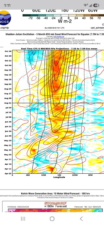
-
2026-2027 Super El Nino
mitchnick replied to Stormchaserchuck1's topic in Weather Forecasting and Discussion
Oh, the "not me, it's you" defense. Lol If you call trying to get to the bottom line of a post/position an attack, I can't help you. But the bottom line is, you haven't denied my synopsis of your post/position because it's accurate. Which is fine. You can take whatever position you want. But clarity matters, that's all. -
2026-2027 Super El Nino
mitchnick replied to Stormchaserchuck1's topic in Weather Forecasting and Discussion
Oh, the need for a cheap shot can't escape you can it? You've shown your true colors. That was easy. -
2026-2027 Super El Nino
mitchnick replied to Stormchaserchuck1's topic in Weather Forecasting and Discussion
So you think everything in law is black and white? You're kidding me right? The point you miss is one doesn’t need to say a lot to make a point. The past 2 or 3 months, you've been triggered every month with the updated seasonal forecasts because they haven't shown a furnace in the east. In essence, your warning is models have under forecasted the strength of ridges in the past which "could" be taken as guaranteed future results i.e. stronger ridges resulting in more heat. But no real forecast because we just don't know yet...but it still "could." That really is the sum and substance of all those posts the way I see it. Where am I wrong? -
2026-2027 Super El Nino
mitchnick replied to Stormchaserchuck1's topic in Weather Forecasting and Discussion
Can't you ever answer a simple question with a simple answer? When I was in law school, they beat into our heads: be brief and to the point. I didn't ask if any models should be taken at face value. I asked if" the ridges will be or won't be stronger and thereby causing current seasonal modeling for the southeast, mid atlantic, and/or northeast to be wrong?" So, do you or don't you? Because right now, your statements are nothing more than "could be." Which leaves them open to you claiming victory if they are stronger and defending the statements if they aren't by saying "I said could be." -
2026-2027 Super El Nino
mitchnick replied to Stormchaserchuck1's topic in Weather Forecasting and Discussion
You've posted this several times this year and even before the 24/25 winter. So are you saying the ridges will be or won't be stronger and thereby causing current seasonal modeling for the southeast, mid atlantic, and/or northeast to be wrong? I mean you could be right, or you could be wrong obviously, but your post appear to be simply saying "current seasonal modeling could be wrong." Forget about the rest of the globe because I'm sure we'll find seasonal modeling too strong or weak with ridges/troughs as that's a given. -
2026-2027 Super El Nino
mitchnick replied to Stormchaserchuck1's topic in Weather Forecasting and Discussion
My point was despite any warming, last year's Niña was pretty canonical. This year's Niño can still happen (canonical) by either the PDO coming around or the Niño overwhelming it. And when you consider all the seasonal models are pretty well aligned to one, odds favor it short of a total failure of all seasonal modeling. -
2026-2027 Super El Nino
mitchnick replied to Stormchaserchuck1's topic in Weather Forecasting and Discussion
Idk, last year's Niña was pretty standard for Niñas with snows along the east coast and cold. -
2026-2027 Super El Nino
mitchnick replied to Stormchaserchuck1's topic in Weather Forecasting and Discussion
Well, I'm happy with the new Cansips. Still too cool up north I suspect, but the precip anomalies are great if you like coastal and temps are more than workable for many I would say. And fwiw, the end of the run is cooling waters around Japan dramatically and warming the NE Pacific. End of -PDO maybe, or at least working on it? Definitely working to build a Niña at the end though. 500mb starting December: https://www.tropicaltidbits.com/analysis/models/?model=cansips®ion=namer&pkg=z500a&runtime=2026080100&fh=4 Surface temps starting December: https://www.tropicaltidbits.com/analysis/models/?model=cansips®ion=us&pkg=T2ma&runtime=2026080100&fh=4 Precip starting December: https://www.tropicaltidbits.com/analysis/models/?model=cansips®ion=us&pkg=apcpna_month&runtime=2026080100&fh=4 -
2026-2027 Super El Nino
mitchnick replied to Stormchaserchuck1's topic in Weather Forecasting and Discussion
It's bad enough current SSTA vary from different products/sources, now we have models prog depictions following along. No wonder there's rarely agreement on forecasts...or on this Board! Lol -
2026-2027 Super El Nino
mitchnick replied to Stormchaserchuck1's topic in Weather Forecasting and Discussion
I thought the discussion was regarding El Niño summers. What relevance does throwing La Nada or Niñas into the mix have? Subtle deflect however. -
2026-2027 Super El Nino
mitchnick replied to Stormchaserchuck1's topic in Weather Forecasting and Discussion
It was. My daughter was born in August of 91'. My wife remembers it in more detail than me! Lol -
Only "leaning" AN, so even if right, possibly muted at times.
-
2026-2027 Super El Nino
mitchnick replied to Stormchaserchuck1's topic in Weather Forecasting and Discussion
Gotta' love how Florida is still in the snow despite being south of the mean slp track depicted on that map. The "A" part I believe...the "I" part, nasso' much.