

bkviking
-
Posts
684 -
Joined
-
Last visited
Content Type
Profiles
Blogs
Forums
American Weather
Media Demo
Store
Gallery
Posts posted by bkviking
-
-
3 minutes ago, bluewave said:
Islip right at 10th coolest June so far.
Time Series Summary for ISLIP-LI MACARTHUR AP, NY - Month of Jun
Click column heading to sort ascending, click again to sort descending.RankYearMean Avg TemperatureMissing Count1 1982 64.5 0 2 1972 64.6 0 3 1979 64.8 0 - 1968 64.8 0 4 1985 65.4 0 5 2009 65.5 0 - 1965 65.5 0 6 2003 66.1 0 7 1992 66.3 0 - 1977 66.3 0 8 1964 66.5 0 9 1974 66.7 0 10 2023 66.8 3 Several of those years stick out as El Niño years. Is that majority ?
-
9 minutes ago, NorthShoreWx said:
0.72" from that cell here. Found the old milk crate we put recyclables washed down the street (was already empty, fortunately). The rainfall total from the prior 3 days was only 0.20", mostly at night.
I just missed it all while driving back from Westchester County, but the traffic still sucked on the dry roads in the Bronx and Queens.
We are well within range and live a few blocks from one another - so your reading corroborates with mine pretty well. Healthy drink today so I won’t be watering the herbs and plants . Lol
-
 1
1
-
-
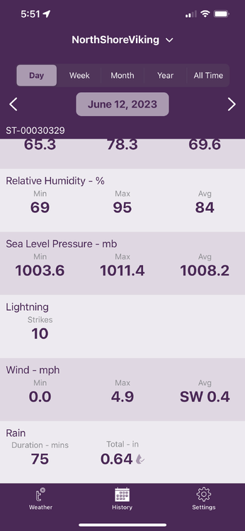
Smithtown LI - my weather station shows .62” from storms today. I’m out east in Port Jefferson and storms keep forming and cutting a little west of me here (into Setauket). Another one on way now. I know family has heavy rain further east into Shoreham area also a short while ago.
-
In Smithtown, LI I have .41” for the day today with that batch of showers that came through around noon. Add .06” yesterday.
-
That big radar blob came right at me in Smithtown last night so ended up with .64”. We take.
-
1
-
-
DCA +0.7 100
NYC +0.9 99
BOS +0.5 98
ORD +0.2 97
ATL -0.2 97
IAH +1..5 99
DEN 0.8 100
PHX 1.6 120
SEA +1.4 95
-
 1
1
-
-
The look in Port Jefferson over the harbor looks like a classic heat wave end of July into August. Slight smoky smell but my nose ain’t the greatest, so probably worse.
-
I am a NYC subforum member but since I’m on LI I spend a lot of time in NE subforum and I must say we should give credit to @Typhoon Tip for having speculated about ENSO “normal “ influences due to new state of SST anomalies. He’s been saying this for years and now with discussion of “RONI” it’s pretty clear Tip was onto something.
-
3
-
-
1.6” here in central LI - Smithtown . Wind driven rain now. Screw this incoming El Niño. They ruin springs and summers. Smell 2009, 2003 type garbage incoming and don’t care for it.
-
DCA -1.1
NYC -1.2
BOS -0.8
ORD +0.1
ATL -0.2
IAH -0.3
DEN +1.3
PHX +1.5
SEA +0.8
-
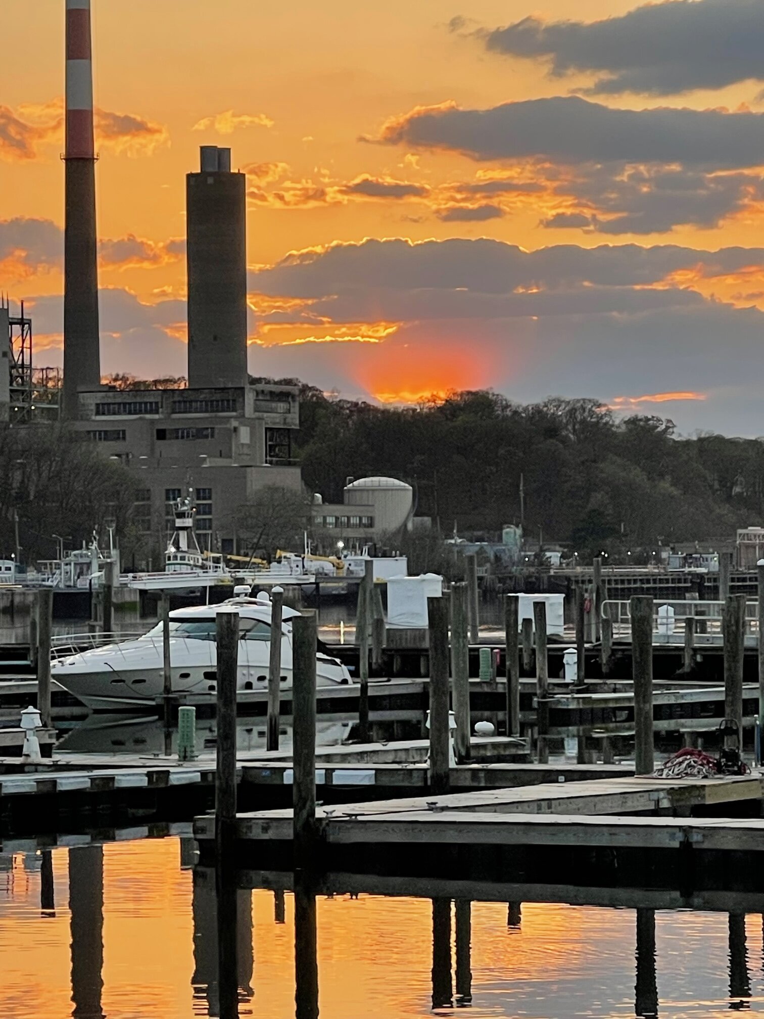
Port Jefferson - with an awesome unique sunset

-
6
-
-
5 minutes ago, so_whats_happening said:
I honestly have been wondering this myself especially with how far east the nino is forming right now. The atlantic as a whole is above average and quite above average along western africa/europe and gulf/ east coast i wonder if we could have a rather quick start to hurricane season as lifting will be focused in this region of the globe and slowly taper off as the season goes on throwing mostly close to home storm potential with shear likely on the increase across the tropics with developing nino as we close the season.
This development of nino has been rather interesting to watch unfold. Im not sure i would go on to the strong side of things for a forecast, moderate may be a peak but that we will find out in due time. Thinking weak nino is probably the right call with an edge toward moderate slowly increasing as we get consistency in time.
From a mid atlantic perspective we are still very much in the grasp of la nina with the dry/warm conditions in the area. Would like to see us moisten up as well as the se besides coastal regions before summer sets in.
What you just said makes sense - because by September the rising motion in Atlantic , while still there, has tailed off. I don’t know.
-
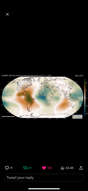
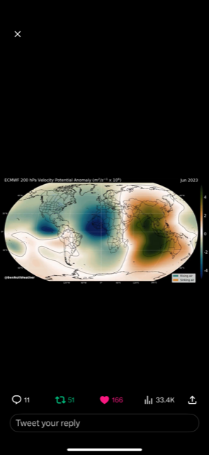
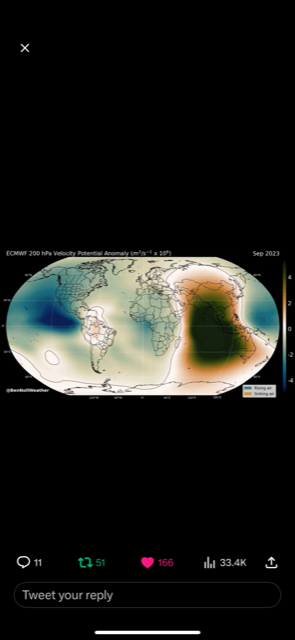
I’m curious to ask about following photos from Ben Noll on Twitter showing the rising and sinking motion forecasts this month, next, June, then September - with a sudden change in June - which continues on his tweet all summer.
This is due to El Niño circulation beginning to take over. My question is , with all the rising motion in East Pacific forecast why does Atlantic also show rising motion ? Shouldn’t the circulation suppress convection there? Any idea what this means - as this is modeled? Does this indicate possibly more active Atlantic hurricane season than normal ?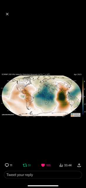
-
In Port Jefferson it started nice but “drizzery” is here and suddenly much cooler.
-
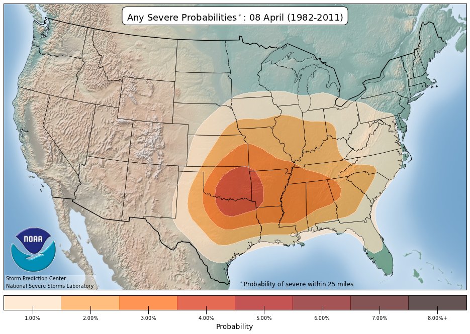
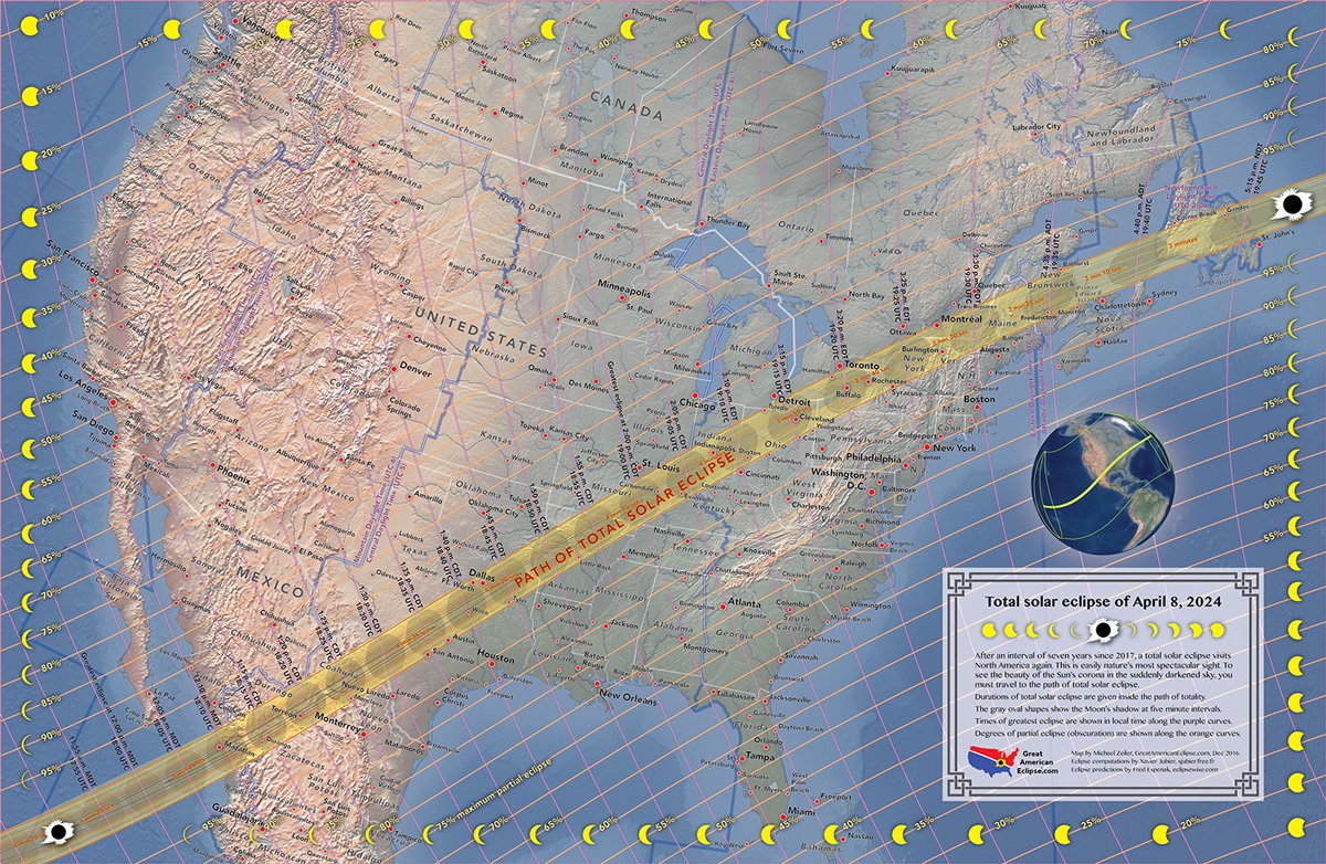
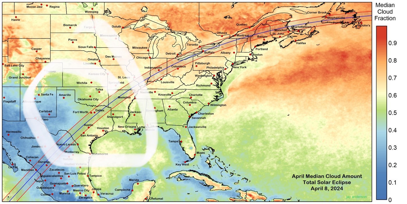
April 8, 2024 is going to be last full widespread eclipse for many of us on this board. At this point it’s about pinpointing the best possible viewing conditions. Sadly , the Ohio valley and northeast Great Lake region is known for cloudiness. So where is it good ? Southwest Texas is the best spot it seems based on these maps but can track as we head into year.


-
2
-
-
Not expecting much here in Smithtown - north shore LI - but lightening constant to west - and hearing rolling Thunder… constantly .. pretty cool even if it wanks out. It’s early April .
-
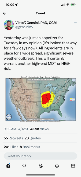
I really don’t understand how other sub forums don’t seem to interact/post about what’s coming 4/4. I mean - some of attention behind this thing is rather extraordinary- high confidence major outbreak larger than what they went through yesterday.
-
1
-
-
22 minutes ago, jm1220 said:
Yeah my bad. The severe weather moments are flickering moments and every outlook is usually more hope than reality.
June 2010. August 2014. November 2022. That’s of top of mind. Our marine layer makes LI a severe storm wasteland most times. -
19 minutes ago, TriPol said:
So what does a building strong el nino do for our springs and summers?
CPC has us warmer than normal. Not sure that means much anymore. But above normal precip - which tends to be an El Niño symptom for our area. Anecdotally, incoming El Niños have been nasty summers. Summer 2009 is one that sticks in mind as such a nightmare. But I’m sure others can offer the true statistics on these.
-
57° in Port Jefferson - with breaking clouds. Was light rain an hour ago. We need sun to have chance at storms. Luckily , I don’t count on it here in Suffolk in April.
-
Gensini is usually cautious…
-
1
-
 1
1
-
-
4/4/23: Gensini is usually cautious..

-
DCA: +1.7
NYC: +1.5
BOS: +1.3
ORD: +0.8
ATL: +2.1
IAH: +2.1
DEN: -0.4
PHX: -0.6
SEA: -1.0
-
1
-
-
3 minutes ago, nycwinter said:
sun is to bright today..
It’s astounding out— wind hasn’t wrecked things here as I expected (yet). Long range shows rain next Saturday again. I hope not. Seems like every weekend has had one bad day - either really cold, or rainy - for many weeks now.
-
2
-


July 2023 temperature forecast contest
in Weather Forecasting and Discussion
Posted
DCA +1.0
NYC +0.9
BOS +0.9
ORD +1.1
ATL +0.9
IAH +2.0
DEN +2.2
PHX 2.2
SEA +1.4