

bkviking
-
Posts
684 -
Joined
-
Last visited
Content Type
Profiles
Blogs
Forums
American Weather
Media Demo
Store
Gallery
Posts posted by bkviking
-
-
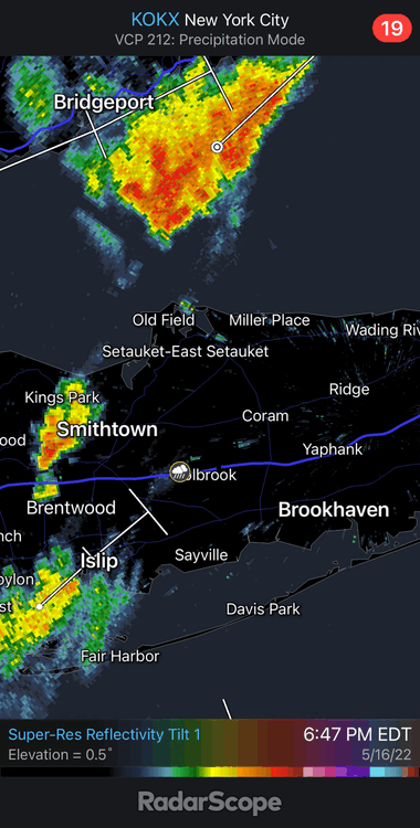
Nice little hook developing with this tiny cell heading towards Port Jefferson
-
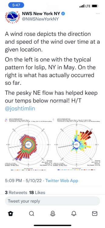
Pretty cool graphic depiction for wind direction at Islip. Didn’t know they analyze this like that. I believe Bluewave has done stats on wind direction for each season.
-
 1
1
-
-
Jeez I blew it in April - didn’t foresee below normal even with solid forecast for blocking.
much more cautious for May despite predicted breaking down of AO/NAO. -
DCA: +0.5
NYC: +0.5
BOS: +0.2
ORD: -0.2
ATL: +1.0
IAH: +1.3
DEN: +0.8
PHX: +1.2
SEA: +0.2
i don’t have a good feel. April turned our colder than I thought . A bit gun shy now. Cool start NE with warmer finish ?
-
 1
1
-
-
1 hour ago, bluewave said:
It will be interesting to see if the models are correct about the near record summer -IOD.


Does this lead to increased tropical activity in the Atlantic? Didn’t we just go through this a few years ago?
-
-
DCA +0.8
NYC +0.9
BOS +0.4
ORD +1.0
ATL +2.2
IAH +1.6
DEN +1.0
PHX +0.4
SEA -0.8
-
1
-
-
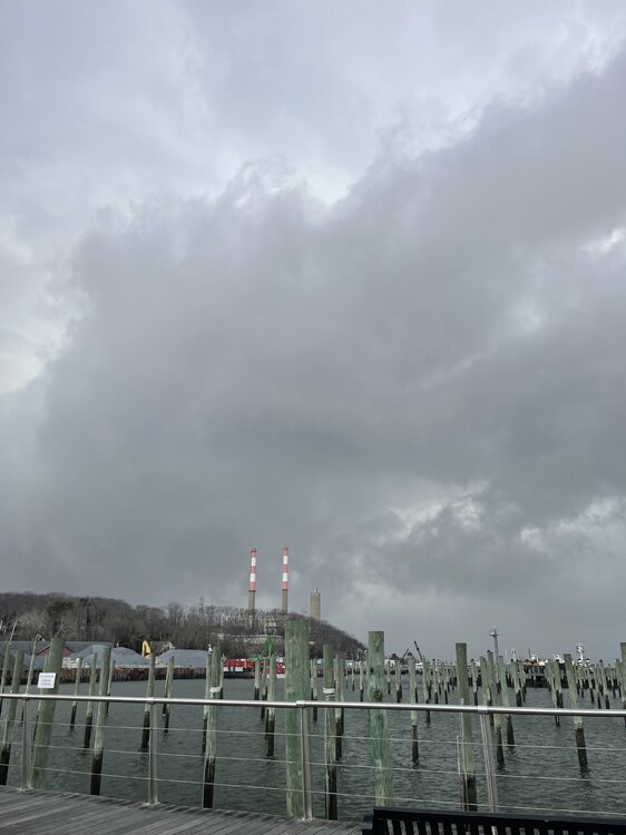
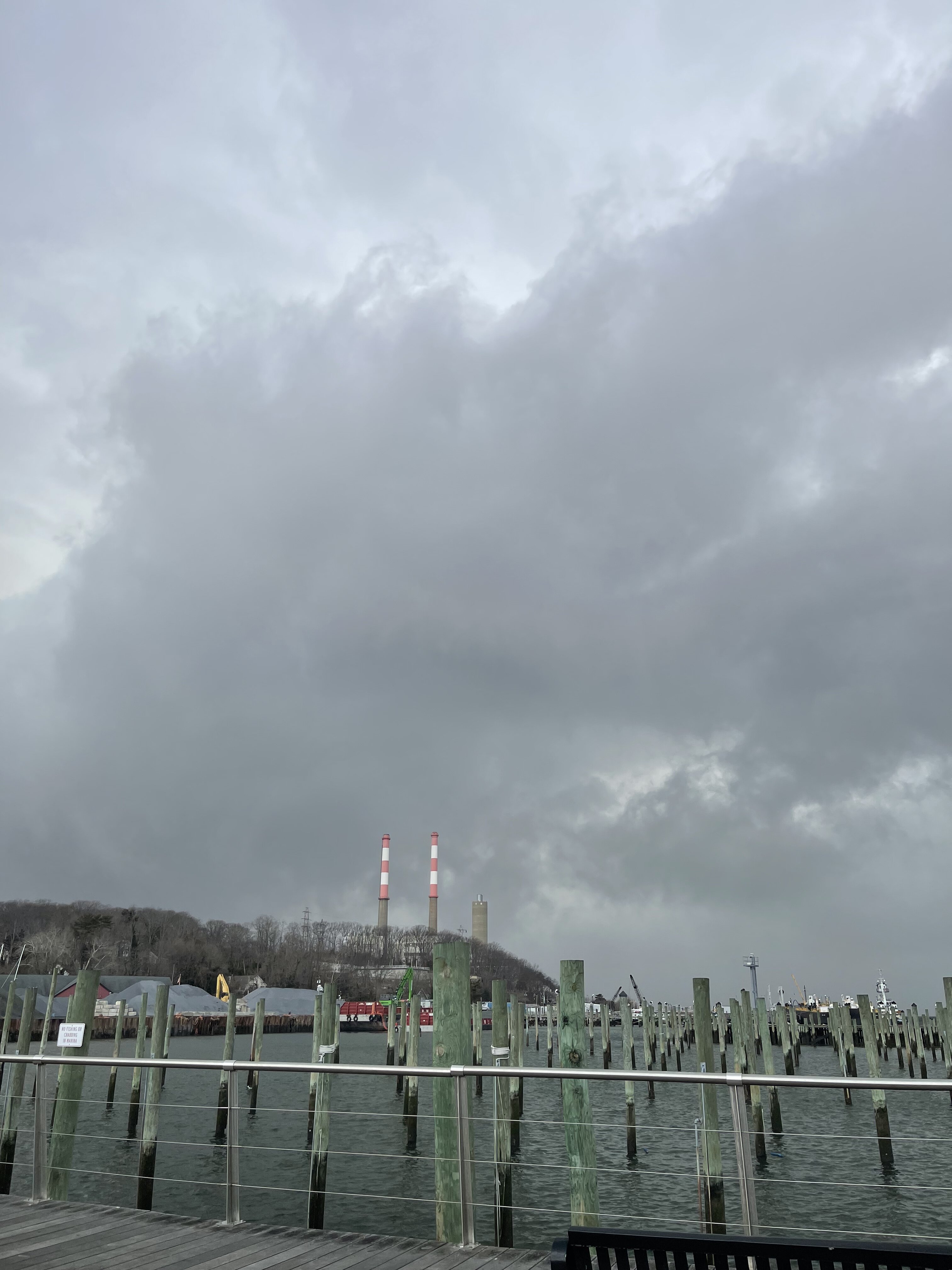
Absolute miserable day on LI North Shore. Endless rain on north and I can see just 20 miles south ain’t dealing with this.
-
1
-
-
Hail here in Port Jefferson LI
-
1
-
-
2 hours ago, NorthShoreWx said:
I was thinking of the ice that you can't see, but perhaps the winds will dry things out enough after the snow stops. 24° here with .5mi snow falling.
I drove from Smithtown (Landing Ave area) to Stony Brook around 6pm and roads were covered with snow and it was a slow drive, so it definitely iced up. On way back just now from Stony Brook to Smithtown and roads were treated.
-
1
-
-
DCA +2.6
NYC +1.9
BOS +1.4
ORD +0.2
ATL +2.9
IAH +2.0
DEN +0.9
PHX +1.4
SEA +.2
-
1
-
-
11 hours ago, psv88 said:
52 today out in suffolk. These temperature swings are killing the roads
I have hated the winters since 2012-13
since then it’s been a mass negative EPO driving winter after winter and I’m sick of it.
I will always love 2002-2003 to 2010-11 far more.
We’ve just had brutal and ruinous springs since the big climate change
the massive EPO is now what determines winter.. and it’s sad bc it doesn’t measure up to the massive negative Ao/NAO era
-
 1
1
-
-
On 2/8/2022 at 1:01 PM, lee59 said:
To me, at this point, there is a storm off the coast early next week, therefore there is hope.
Port Jefferson - snow squall warning now in effect
-
2
-
-
I wish he was right. I never considered this before but Oil bills are out of control. Gas is a little different , but with it.
I hate hate seeing a - EPO build now . Just screw off cold producer. Just the theme since we swapped out of -AO/-NAO period ending 2011. EPO is becoming our main producer of cold and snow since 2011.I got my 40” of snow here Smithtown and would love a run at a record but it ain’t happening so - not happy with change in long range models at this point in season .
-
I’m Port Jeff Village now. Seems like 3/4
-
1
-
-
8 minutes ago, wdrag said:
Guess it’s coming. Snow and ice. If it starts at 5a there will be some problems on some roads. I think salt impact from Prior event maybe waning. Am pretty sure DPW and MPING will be busy at sunrise.
Thank you Walt . I’ve been waiting for someone to assess this issue - whether issue or not / but need someone to do it. So thank you
-
15 minutes ago, NorthShoreWx said:
Blizzard of 78 on LI. After all the storms since 1996, '78 is still the benchmark for LI blizzards.
https://northshorewx.com/19780207.html
https://www.longisland70skid.com/blizzard-of-1978/

I’m with you and posted this in NE forum - I will say I was you but family photos and memories corroborate that that beast was our best :I lived in Sound Beach on north shore of LI and I still consider this the standard. Of course, I was younger and didn’t know how to compare it to anything else. Been through so many “Blizzards” now in life it’s hard to compare all these 20” storms other than to say I know the 1/29/22 blizzard had nice drifting and cold temps with no mixing issues. PD2 similar - just brutal cold before the storm and kinda windy and lotsa blowing snow. Some had more turbulence with thunder and insane snow rates (2/8/13, Boxing Day); some were novel - 1996 was the first really 20 incher on years. Still in my heart - 1978 holds a special place and seeing analysis all these years later it was a classic cold blizzard with some of the strongest winds of them all and biggest drifts - for my area on North Shore of LI.
-
2
-
-
29 minutes ago, KEITH L.I said:
The greatest storm for Long Island and New England. I was 19 years old in Babylon Long Island. Parts of the Long Island Expressway was closed for 3 days. Drifts must have been 5 to 6 feet. Way above garage door. The most snow I have ever seen.
Agree with you here. I lived in Sound Beach on north shore of LI and I still consider this the standard. Of course, I was younger and didn’t know how to compare it to anything else. Been through so many “Blizzards” now in life it’s hard to compare all these 20” storms other than to say I know the 1/29/22 blizzard had nice drifting and cold temps with no mixing issues. PD2 similar - just brutal cold before the storm and kinda windy and lotsa blowing snow. Some had more turbulence with thunder and insane snow rates (2/8/13, Boxing Day); some were novel - 1996 was the first really 20 incher on years. Still in my heart - 1978 holds a special place and seeing analysis all these years later it was a classic cold blizzard with some of the strongest winds of them all and biggest drifts - for my area on North Shore of LI.
-
1
-
-
2 hours ago, tim said:
..very strong barometric readings..the old "banjo" barometer approaching 31.00..( actually 30.85"..not sure how accurate it is)..
You just had me check mine and yes - 1035mb so that’s good for 30.6” or something so quite high
-
DCA +1.2
NYC +1.0
BOS +1.0
ORD -1.4
ATL +1.2
IAH +0.6
DEN -0.4
PHX 0.3
SEA -1.2
-
1
-
-
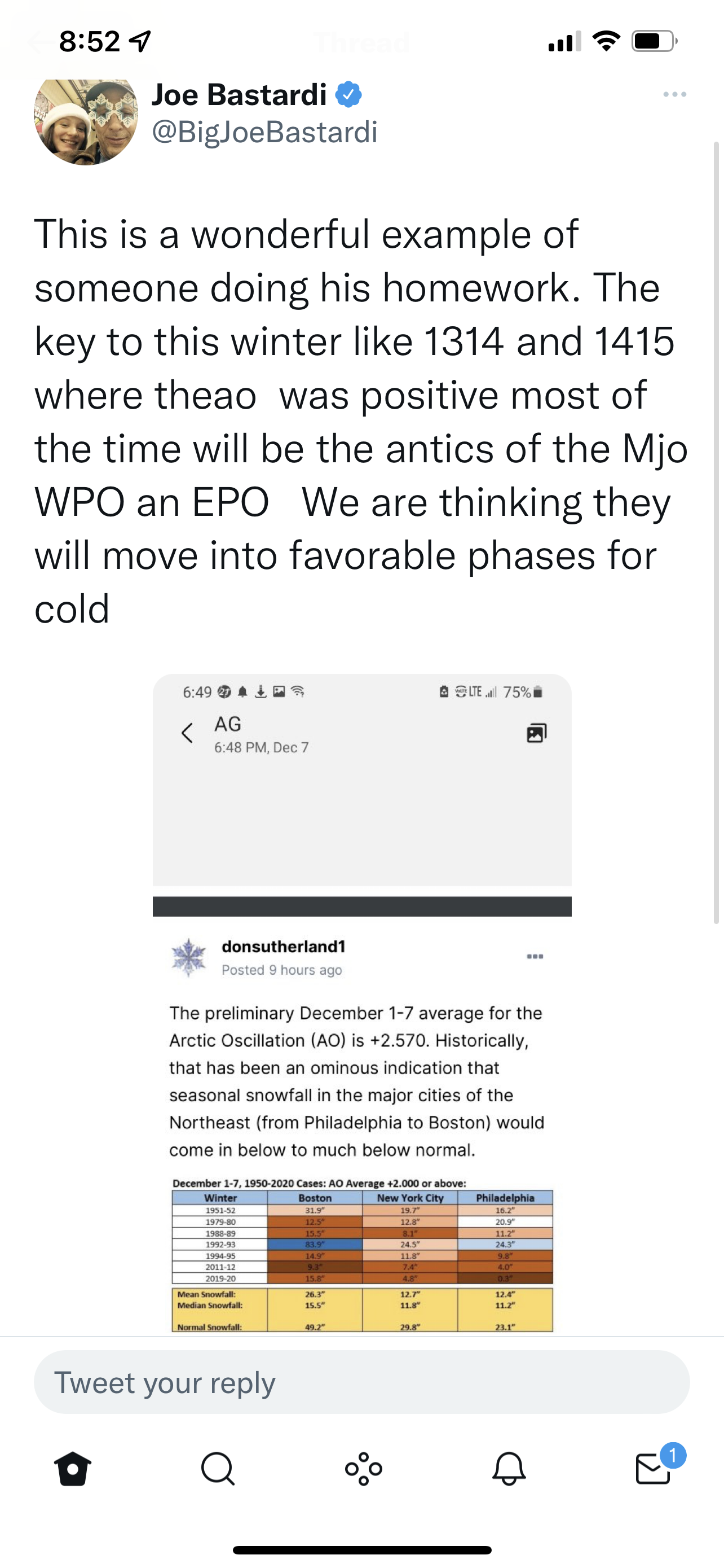
11 minutes ago, donsutherland1 said:
A rapidly intensifying storm will move northward off the Atlantic coast bringing blizzard conditions to parts of Long Island and eastern New England. During the height of the storm, winds could gust past 60 mph in that region with temperatures falling into the teens. Visibilities will decrease to 1/8 mile or less. Moderate to heavy snow will reach Newark and New York City for a time, but the heaviest amounts will fall east of those areas.
Snowfall estimates:
Boston: 16"-24"
Bridgeport: 7"-14"
Islip: 14"-20"
New York City: 6"-12"
Newark: 5"-10"
Philadelphia: 4"-8"
Poughkeepsie: 2"-4"During the January 15-February 15, 1950-2021 period, 37% of Boston's 10" or greater snowstorms have occurred during an AO+/PNA+ pattern. In contrast, just 12% of New York City's and 10% of Philadelphia's 10" or greater snowstorms have occurred with such a pattern. Not surprisingly, for New York City and Newark to reach 10" or more, one will need the storm to phase somewhat farther to the west than is currently modeled.
The ENSO Region 1+2 anomaly was -0.5°C and the Region 3.4 anomaly was -0.8°C for the week centered around January 19. For the past six weeks, the ENSO Region 1+2 anomaly has averaged -1.05°C and the ENSO Region 3.4 anomaly has averaged -0.98°C. La Niña conditions will likely persist through meteorological winter.
The SOI was +23.65 today.
The preliminary Arctic Oscillation (AO) was +1.603.
On January 26 the MJO was in Phase 8 at an amplitude of 0.847 (RMM). The January 25-adjusted amplitude was 0.910 (RMM).
Based on sensitivity analysis applied to the latest guidance, there is an implied near 100% probability that New York City will have a colder than normal January (1991-2020 normal). January will likely finish with a mean temperature near 30.2° (3.5° below normal).
Don thank you for keeping the board aware of the statistical odds for each combo of blocking for biggest snowstorms NYC and southwards.
Like any good long term weatherboard follower (weenie) , I understand the role each type of blocking (EPO, PNA, AO, NAO) plays in our weather. I’m curious about the current storm bc I certainly believe the predicted lack of Mid and upper Mid Atlantic projected severe/historic totals makes sense without blocking. My question is , the AO in a negative phase suppresses the overall jet stream more south. Both you and Uncle W have shown the AO to be highly critical . But isn’t it the role of the NAO to block progression of storms and force them to consolidate and slow down ? Does the AO provide that - I know both indexes often correlate with one another but not always. My thought is we have the PNA to sharpen the trough and dump the cold but wouldn’t a -NAO be the best index to have ensured more of the Atlantic coastline saw historic totals?-
2
-
-
DCA +1.1
NYC +0.9
BOS +0.8
ORD -1.6
ATL +1.2
IAH +2.8
DEN -0.7
PHX +1.5
SEA -0.3
-
1
-
-
Joe B quoting our very own Don S.

-
7
-
-
DCA + 1.2
NYC +1.3
BOS +1.0
ORD +1.2
ATL +1.6
IAH +1.8
DEN +2.5
PHX +2.8
SEA -0.5
DCA 8”
NYC 28”
BOS 42"
ORD 44”
DTW 25”
BUF 88”
DEN 55”
SEA 22”
BTV 85”
-
1
-


May 2022
in New York City Metro
Posted
Yep. Heavy rain , a little breezy in PJ. Was really trying to have hope. Nope. Cleaned truck or pollen though