

Heisy
-
Posts
9,030 -
Joined
-
Last visited
Content Type
Profiles
Blogs
Forums
American Weather
Media Demo
Store
Gallery
Posts posted by Heisy
-
-
Need the sort of optimism that [mention=8091]Heisy[/mention]is putting out on here and the PhillyWx forums.
To answer Ralph’s question I get most of my joy in this hobby tracking/chasing the big one and watching heavy snow fall. Main reason Ive chased events over the last 10 years. Finally last year I chose ground zero for an event. I don’t care if we get 12” in May. Of course I’m not going to complain about having it stick around.
I pretty much agree with Cape, could luck into something end of month, nothing really popping yet but potential is there for that to happen. Then we hope for a reload end of month.
.-
 1
1
-
-
Just one of those years… Night all. Can’t do anything about it. Here’s both events

.-
 1
1
-
-
It still does bring NS across unlike GFS, so we’ll see if it’s able to damper the cut at all
.-
1
-
-
Euro digging storm 2 into Mexico lol… I hate this winter man

.-
 2
2
-
-
Who caves first EPS or GEFS for 2nd storm progression? Day 6 euro/eps have NOrthern stream energy streaming across first which lowers heights. GFS doesnt.
Find out soon…
.-
1
-
-
Cmc does break some NS energy out ahead of main ULL, but nothing like 12z euro/eps
We’ll find out in about 45 mins
. -
Here is proper time stamp…
Only draw back for GEFS caving is Canadian evolution is more similar to GFS
. -
EPS (18z) vs GEFS (00z) day 6
Completely different, euro, colder solution brings NS ahead. One side is going to cave very soon
Knowing this winter…
Woops I picked the wrong times, but same idea
. -
NAM even colder heading into the Sunday event this run. Hope to see the temps improve even more over the next 24 hours.
Wave is def flatter and in the 12z icon/ukie camp, but it’s the NAM at 84 hours. I’m really hoping we see a change for storm 2 on 00z models.
The 18z EPS is encouraging. Both the euro and gfs differentiate on how they get there for storm two
12z euro (and now 18z) break a northern stream shortwave out ahead of the main one, this lessens heights and reinforced a little cold.
GFS doesn’t do this at all. GFS was super amped with this next event last couple days so hopefully we see a trend S tonight.
For us to get snow out of system two we need that wave near the Lakes in the euro part of the gif to trend stronger. The main
wave trended flatter won’t hurt either
.-
1
-
-
18z eps has better confluence/NS out ahead of main shortwave at end of run

.-
4
-
-
Yeah, that's how it works with progressive flow. Yet you constantly pop in here and post about 'good looks' with transient lows hauling ass through the 50-50 region lol.
There’s a big difference between how the pattern has been last 7 days/next few days and end of the month. That’s all I’ve been saying. There’s at least potential there towards end of month. We just need to time things almost perfectly. Just seems we need the absolute perfect H5 setup to get snow these days.
.-
3
-
-
Not really, it’s still a really impressive storm even if it’s rain.
I mean if you get off on rainstorms, then, I guess?
.-
1
-
-
Gonna be tough for 95 folk for these 2
.
Well I’m not a big enough weenie to not realize storm 2 def favors NW. maybe we can get some front end like 12z euro if shortwaves progress right. However if there is another event around the 30th that does the same thing then I give up. Not having blocking right now is devastating
.-
1
-
-
Not having any blocking is just devastating right now. Hope cmc/GEPS is right so any shortwave around 29/30th is forced farther S.
Even here on the gfs for the LR storm, we have a 50/50 but there’s no blocking so the 50/50 keeps moving N
. -
We all know it’s gonna happen. This stuff makes me want to kick puppies. GFS even finds a way to form a miller B around the 30th that rains on us.
If eagles don’t win this weekend I’ll probably lose it

.-
 1
1
-
 1
1
-
-
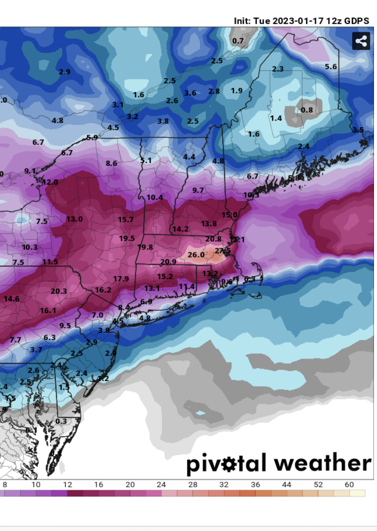
Here’s the ukie for those wondering, sharing from Philly forum which is why our region is the focus, this is snow depth though. I’ll see if I can get a better image

.-
1
-
1
-
-
GEFS is a fucking thing of beauty for next week. Best possible signal in every way from an ensemble at that range. It's the GEFS so take it for whatever you think its worth but damn.
See I was ninja'd by everyone lol
It’s a little skewed by like two members that go insane
Still, NW where you are is in good spot regardless
Euro was able to hold on the cold better because a part of the NS broke ahead and phased with the prior event so we got a little transient 50/50.
If that trends stronger and flow trends faster could be a good event
Hell, 3” is a HECS at this point even up here in Philly
.
-
1
-
1
-
-
That one was run out of my basement….GGEM has to be the best model for phantom weenie snow

How about all the models caving to the GFS with phasing the day Day 4-6 wave. Crazy. See if euro does it at 12z as well.
For us down in Philly we need a faster NS, but I really like the setup day 9 suddenly, long way out though obviously. You can see the GFS/CMC races the NS out ahead of the main vort with different degrees of strength and placement.
.-
 1
1
-
-
That day 8-10 event will be interesting. We’ll see if euro starts showing the NS race ahead like GFS/CMC do today.

.-
1
-
-
GEFS has the smoothed out setup for around the 30th too. Cold done and some energy in Southwest

. -
GFS gives us a true good old fashioned SECS around the 30th. Get the cold air here magic can happen
.-
1
-
-
18z GEFS coming in a little improved as well for the time period I mentioned

.
Nice split flow action forms on the SW, headed to work, but really positive ensemble runs today. Let’s build on it over the next few days.
.-
4
-
-
18z GEFS coming in a little improved as well for the time period I mentioned
.-
3
-
-
GFS now the only model that’s phasing NS with southern ULL for the day 5-7 system so hard to trust its evolution beyond that.
Icon was the only other model and it backed off at 18z
Not that anyone cares, but right now I’m thinking we have 7-9 days of hell to get through. Maybe the day 5-6 system tracks just right with NS and trailer vort for some front end or NW frozen, then we face the possible cutter around the 26/27th…However, it then finally looks like we could have an opportunity if EPS etc is right.
Stealing this from my Philly forum, but the trend is our friend right now. Just another week of patience. If things hold by next weekend we could have something on the radar to track.
.-
5
-
January Mid/Long Range Disco 3: The great recovery or shut the blinds?
in Mid Atlantic
Posted
I remember literally falling into a depression in high school from the March 2001 bust. That doesn’t happen anymore. I still get a little seasonal depression in April, but I think that’s just because my routine of checking models 20x a day ends. I think a part of me loves this hobby because when a big event happens it takes us away from the worries of real life for a few days. As a kid I loved the hype and how every thing got shut down from a snowstorm. Still do I’ll I guess. If it doesn’t snow this year it will suck, I’ll be a little angry, but that’s about it…
.