

2001kx
-
Posts
2,261 -
Joined
-
Last visited
Content Type
Profiles
Blogs
Forums
American Weather
Media Demo
Store
Gallery
Posts posted by 2001kx
-
-
5 minutes ago, MAG5035 said:
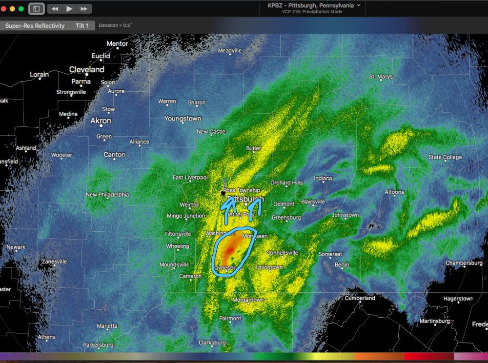
Next couple hours are crucial but my chances for getting that high are slipping away the longer that band stays arced to my NW and north. It seems to be setting up over 2001kx over to just NW of IPT. @2001kx has to be getting crushed. This is the band that's going to see the excessive totals and it's setting more NW than any guidance had it earlier today.
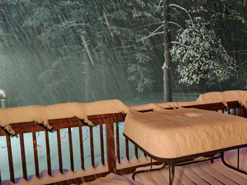
Up to 8" with moderate rates. Snowing decent but I probably lost my outside chance at 20".
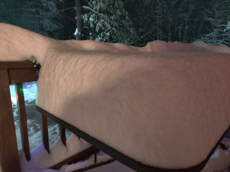
it just keeps getting heavier...up to 13" as of 9:25
-
 5
5
-
-
Just now, jm1220 said:
Must be coming down insanely hard at your place. Clearfield County lit up in yellow!!
I wouldnt call it insane but its heavy..Bigger flakes as well.
-
Just now, jim123 said:
stay safe!
I tried to go for a little ride but my road is unplowed ( I live on a 1 mile dirt road)
-
1
-
-
Just now, paweather said:
Good stuff 2001K you deserve it. Keep it coming.
thanks..finally a storm over 12" here.
-
1
-
-
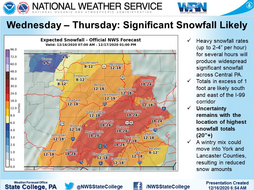
Special Weather Statement
National Weather Service State College PA
907 PM EST Wed Dec 16 2020

PAZ006-011-012-017-018-024-037-041-170300-
Potter PA-Northern Centre PA-Northern Clinton PA-Cameron PA-
Clearfield PA-Northern Lycoming PA-Tioga PA-Cambria PA-
907 PM EST Wed Dec 16 2020

...A BAND OF HEAVY SNOW WILL AFFECT THE ALLEGHENIES AND
NORTH-CENTRAL MOUNTAINS OF PENNSYLVANIA...

HAZARDS...A band of heavy snow which can rapidly reduce visibility to
near zero. This band of heavy snow is producing extremely heavy snow
at the rate of nearly 2 inches per hour.

LOCATION AND MOVEMENT...At 900 PM EST, a nearly stationary band of
heavy snow was along a line extending from near Elkland to near
Lecontes Mills to Curwensville and Northern Cambria. The band may
move only slightly to the east across Clearfield and Cambria
Counties over the next hour.
-
7 minutes ago, hawkeye_wx said:
Man, I'd love to be under the very heavy band that has been parked west and north of State College. That kind of thing is rare here in Iowa.
Its rare here too.
-
4 minutes ago, hawkeye_wx said:
Man, I'd love to be under the very heavy band that has been parked west and north of State College. That kind of thing is rare here in Iowa.

-
1
-
-
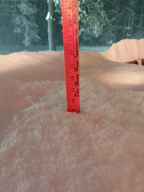
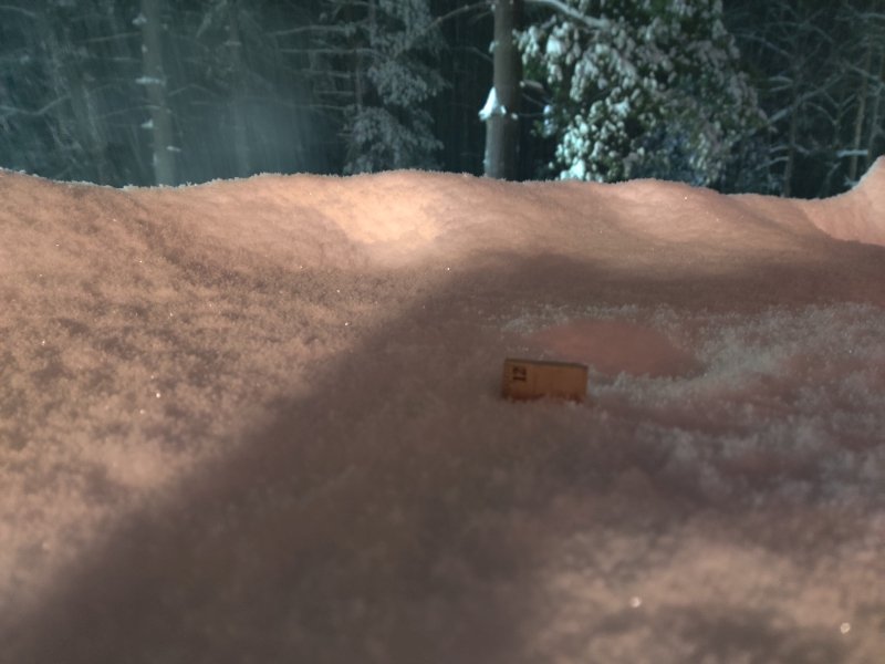
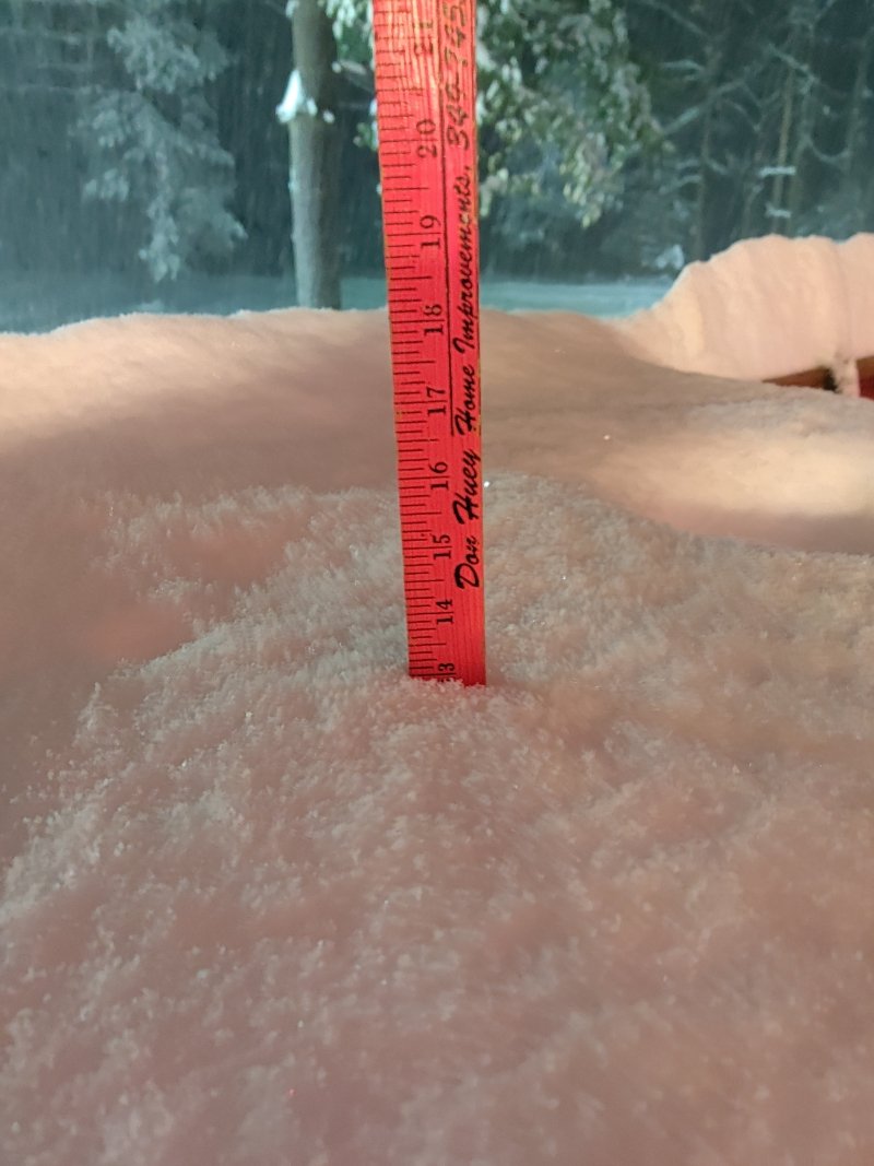
a little over 11.5" now
-
10
-
-
Up to 10" now
-
2
-
-
PAZ017-024-033-170130-
Somerset PA-Clearfield PA-Cambria PA-
729 PM EST Wed Dec 16 2020

...A BAND OF HEAVY SNOW WILL AFFECT SOMERSET...CLEARFIELD...AND
CAMBRIA COUNTIES...

HAZARDS...A slow-moving band of heavy snow which can rapidly reduce
visibility to near zero. The snow intensity is extremely high and
thunder has occurring close to Johnstown.

LOCATION AND MOVEMENT...At 726 PM EST, a band of heavy snow was
along a line extending from near S.B. Elliot State Park to Prince
Gallitzin State Park to near New Centerville, moving east at 15 MPH.
-
up to 9.25" now
.jpg.2af73c96be6520ea37dd0fd901eade54.jpg)
.jpg.56fcb15caf9fe4f9a12ad1cf21bfa312.jpg)
-
3
-
-
-
1 minute ago, MAG5035 said:
7.0" Moderate snow.
That band associated with the thundersnow over Mt Davis (Somerset County) is lurking. I did see the GLM flash product on the COD satellite page pick up on about two or three strikes back about an hour ago. The extra instability likely aided by the SE flow over the one ridge line in that region.
Im keeping pace with you so far.
-
also its dumping snow again
")
-
1
-
-
6.7" as of 6:50pm
-
under a nice band right now.
-
4 minutes ago, MAG5035 said:
That stuff about to come up into town from the south looks nuts. Checked the CC product to make sure that wasn't a mix lol (50dbz!)
Bring it up our way
-
4.8" as of 5:30
-
3.8" as of 4:30
-
28 minutes ago, MAG5035 said:
Definitely, the radar seems set up real nice right now. You may miss the most intense bands but I think you should get to at least 12" without too much drama.
Thanks mag..
-
31 minutes ago, MAG5035 said:
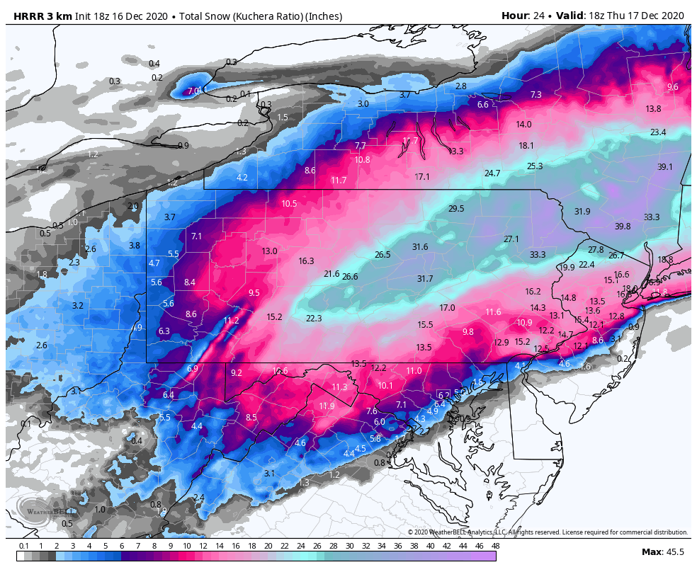
Wow on the 18z HRRR. And these Kuchera totals aren't doing anything mind blowing ratio wise. Did some calculating and KAOO and UNV get to their ~2ft amounts via 14-15:1 ratios. Selinsgrove (SEG) and IPT get to their nearly 32" totals via a 13-14:1 average. This is doable if the QPF ends up that high in the deform bands.

Think I have a shot at 12" back here?
-
at least a solid 1" here so far.
-
-
Just now, Wmsptwx said:
Yes sir 18 in 2017. My fav storm to date.
I thought so..You are the hot spot now (well i guess we'll see tomorrow)

December 16 2020 CTP Snowstorm Disco and Obs
in Upstate New York/Pennsylvania
Posted
yep had to get the yard stick..how long do you think this will last here?