

2001kx
-
Posts
2,320 -
Joined
-
Last visited
Content Type
Profiles
Blogs
Forums
American Weather
Media Demo
Store
Gallery
Posts posted by 2001kx
-
-
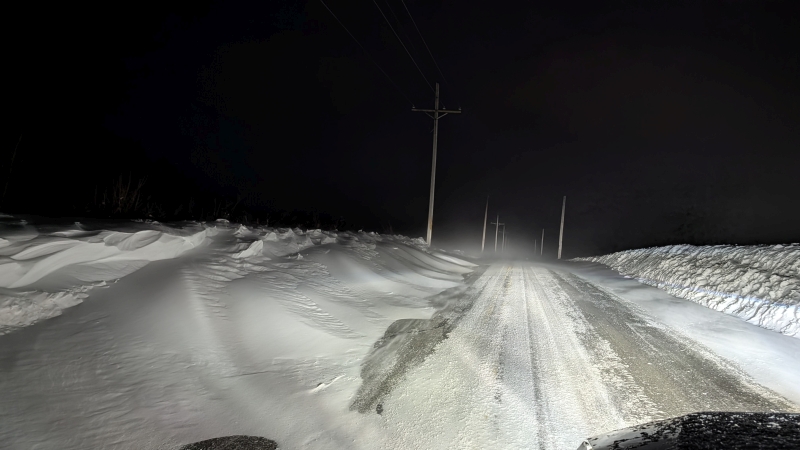
Some of the roads were tough to get through this morning..
-
 5
5
-
-
Low yesterday at my place was -18
Houtzdale was -21 on the car thermometer

-
6
-
-
Is there a way to remove the right-hand sidebar so the posts fill the entire page?
-
11.5" storm total
-
3
-
-
-
-
9.5" as of 2 pm
-
2
-
-
7 minutes ago, WmsptWx said:
Currently in Huntingdon county. Will be back in Clearfield at some point in the next year or so.
To people wondering "Why?" I'm at SCI-Huntingdon doing a stay. Got caught f'n the mayor's wife and they threw me away. On my first day I beat up the King Dick and made him my bitch. This is his phone I use. He had a corrupt CO smuggle it in and as He Who Controls the Smack, Controls the Joint, I have a phone.

-
1 minute ago, WmsptWx said:
Snow appears to be re-emerging as the dominant precip type here. Just spent the last two hours shoveling. Didn't measure but it's a lot.
Not in Clearfield any longer?
-
7.75"
With heavy snow
-
6.25" so far
-
3
-
-
Snow just started here (Just a few flakes)
-
1
-
-
23 minutes ago, Ruin said:
Hope the radar fills in more a little gap between the system
Yeah it looks disorganized as of now..
-
Wxrisk (DT)

-
2
-
-
from pitt forum

-
2
-
-
2 minutes ago, paweather said:
Thanks
-
1
-
-
-
6 minutes ago, GrandmasterB said:
Who’s in for a contest? Total storm accum for KMDT. Closest wins. None of that without going over bull****. I’ll keep track. You win pride and maybe a small prize. I’ll close it at 11pm tonight.
14.5
-
1
-
-
-
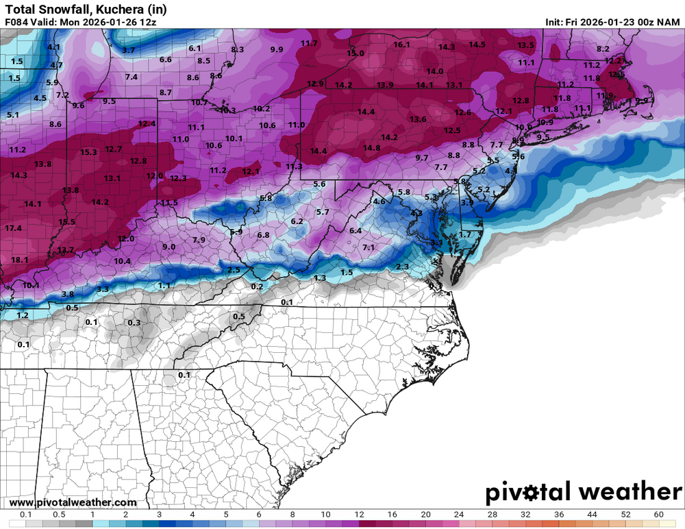
WSW issued here for Wed.
PAZ004>006-010-011-017-210900-
/O.NEW.KCTP.WS.A.0001.260121T1700Z-260122T1500Z/
Warren-McKean-Potter-Elk-Cameron-Clearfield-
Including the cities of Warren, Clearfield, Bradford, Emporium,
Coudersport, St. Marys, DuBois, and Ridgway
450 AM EST Tue Jan 20 2026

...WINTER STORM WATCH IN EFFECT FROM WEDNESDAY AFTERNOON THROUGH
THURSDAY MORNING...

* WHAT...Heavy snow possible. Total snow accumulations between 3 and
  6 inches with locally higher amounts possible.

* WHERE...Cameron, Clearfield, Elk, McKean, Potter, and Warren
  County.

* WHEN...From Wednesday afternoon through Thursday morning.

* IMPACTS...Plan on slippery road conditions. The hazardous
  conditions could impact the Wednesday evening and Thursday morning
  commutes.

* ADDITIONAL DETAILS...A several-hour period of 1 inch per hour
  snowfall rates is possible Wednesday evening, which could result
  in rapidly-deteriorating road conditions across the Watch area.
-
3
-
-
Did'nt measure but looks to be 4-6" here..
-
5
-
-
-5 just outside of Houtzdale this morning.
-
4
-
-
-3 This morning around Houtzdale
-
2
-
-
4" here now but was prob closer to 4.5" - 5" earlier.
-
2
-


Central PA Spring 2026 Discussion/Obs Thread
in Upstate New York/Pennsylvania
Posted
About 3" of snow