
frostfern
-
Posts
2,000 -
Joined
-
Last visited
Content Type
Profiles
Blogs
Forums
American Weather
Media Demo
Store
Gallery
Posts posted by frostfern
-
-
1 hour ago, Powerball said:
I'll take the bait...
I'm not laughing at your health problems (and I certainly wish you get the help you deserve). I'm laughing at 2 things:
1. Your clapbacks at Stebo, because I just plain don't like him (the reason why has nothing to do with you).
2. The fact that your extremely unrealistic expectations for weather in Grand Rapids in spite of its climo, which has been explained to you ad-nauseam, has you becoming so unhinged that you're devolving into nonsensical diatribes over it with strangers on an internet forum.
And I already suspected you have health problems, FYI. Just not the physical kind with the way you've been carrying on. I actually think it's sad (not funny), which is why I've been giving you Weenie reactions.
I hope this helps and please be blessed!

You have been putting the tag on every post I make obsessively since May. Nobody else has been doing this. Not every single post, regardless of actual relevence. And you do not single other people out this way. It's obsessive and spiteful you've been doing it for two months now.
I really don't give a damn what you think my expectations are. I'm just disappointed after the entire month of May and majority of June being stuck under constant blocking and choking smoke. That wasn't normal "climo" at all. Missing a lot of really good action by very small margins a lot of the time this past month isn't really a "climo" problem either, just bad luck. You have never "explained" anything to me I don't already know. I've lived hear almost 40 years.
I became "unhinged" because of other things in my life that have nothing to do with the weather or you. Weather is an escape for me. You being an unholy nuisance just tipped me over the edge. If you actually want to "help" me simply stop talking to me and tagging my posts. I block you and you block me and we're done with it. If you continue to harass me I'll bring it up with moderators and if they have no solution I'm just going to leave. You can then have your delightful power trip of trolling a long time member off the board and jerk yourself off all day.
I'm offering an apology to Stebo as he didn't deserve my outburst. We have our differences but we normally get along okay. I'm having a hard time wanting to apologize to you though. Sorry, I just don't like you. I'm going back and cleaning up the old posts I made on 2 hours of sleep if the mods haven't already.
-
 1
1
-
-
17 hours ago, Powerball said:
Here's a sanity check for the cliff jumpers from DTX.
TL;DR = At least give these long summer days a chance to play out before declaring a bust...
000
FXUS63 KDTX 281118
AFDDTX

Area Forecast Discussion
National Weather Service Detroit/Pontiac MI
311 AM EDT Fri Jul 28 2023
Shortwave moving through the Straights early this morning, with with
mid level jet forcing supporting widespread showers and
thunderstorms moving through northern Lake Michigan. However, as the
activity propagates southeast, outflow boundary is outrunning the
support and beginning to run into the warm and dry mild levels in
place over southern Lower Michigan, where 700 MB temps of 12 C
reside. If showers/thunderstorms don`t make it in, at the very least,
the outflow/frontal boundary will likely hang around along/north of
I-69 today, which could serve as focus for convection today, as 700
MB level begins to moisten up and temps cool/lower to around 10 C,
making for a marginal cap, especially as surface dew pts ramp up into
the 70s. Right now, seeing dew pts around 80 degrees around Quad
Cities which will be directed toward far southern Lower Michigan this
morning, with several upper level filaments also tracking through.
With showers and now thunderstorms noted over northern Illinois
(hires models not capturing), certainly need chance pops in for this
morning. The issue is, it looks like we get into upper level
negative PV advection/general subsidence for the afternoon, which
suggests convective activity may be limited or non-existent during
this time, allowing for instability to build to moderate to high
levels. SREF weighted local probabilistic guidance suggests Mlcapes
of 2000 J/kg, while the 12z NAM suggests MLcapes aoa 4000 J/kg, but
upper 70 dew pts to near 80 degrees looks too high, low to mid 70s is
more realistic. That moisture content will also make it tough for
maxes to get much past 90 degrees, and that assumes skies will be
mostly sunny-partly cloudy for a good portion of the afternoon.
Either way, southeast Michigan should be primed for severe weather
(mainly wind), with a significant shortwave/jet streak (0-6 km bulk
shear of 50-60 knots) appearing to come out of Minnesota/northern
Wisconsin late in the day. Lead edge of the wind gradient/height
falls suggests activity developing by early evening (5-9 PM) and
quickly growing upscale and diving southeast, as substantial 500 MB
height fall center (30-60 M) is progged to track through Lower
Michigan tonight.
Derp. Didn’t happen. 80 dews broke the cap and cut off the supply way south of the dynamics.
-
1
-
-
Weak.
-
 1
1
-
2
-
-
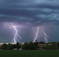
I'd gladly take this "junkvection" as it's full of lighting. Sucks to always be so close but miss out.
-
1
-
-
31 minutes ago, outflow said:
It's like mother nature seen this and said hold my beer.....
Side note it still amazes me how summertime convection can make humans and computers look completely clueless when it comes to forecasting even 12 hrs in advance, but in the same sense it wouldn't be as fun if we knew exactly what would happen would it
You can easily recover from junkvection overhead at 6:00am. Non-overturned airmass advects in from the SW by evening. Being downstream of junkvection is worse.
-
1
-
-
13 minutes ago, CheeselandSkies said:
06Z 3K NAM seems to have a little better handle on the current IL stuff (although I think still weaker with it than reality) than the HRRR, and it fires discrete sups in southwestern WI by 22Z.
Not sure why SPC would introduce a 2%
 region at 1730Z yesterday, only to remove it with the first SWODY1 today.
It will be I-94 and south again unless the MCV that develops can draw the juice back north.
-
 1
1
-
-
I don’t know if the RAP forecast of 3000 MLCAPE GRR office mentioned has the current hulking cold pool over WI and ongoing convection over Illinois. Its great if it completely collapses and suppresses convection during the heating hours, but it’s always hard to recover here without strong southwesterly flow. Are they really still thinking its going to hit 92 at GRR?
-
1
-
-
Crapvection outflow.

-
1
-
-
16 minutes ago, nwohweather said:
Everyone needs to calm down, downed trees in the yard aren’t fun anyways
More like "everyone" needs to stop trolling by being intentionally dense. I was never wishing for downed trees. It was an underperformer in terms of photogenic skies and lighting for my back yard. That's it. I didn't downplay anything for anyone else.
-
2
-
-
1 minute ago, Stebo said:
Its not a gotcha, I just don't see how its possible.
I don’t see the point of this argument. I don’t care about your definition of “miss” vs “no miss” in terms of rain and distant thunder since that isn’t my criteria but yours. It wasn’t electrically cooperative near me. I also only got 0.5” for the day. I live northwest of the airport, as most of the city is northwest of the airport.
-
2
-
-
6 minutes ago, Stebo said:
Oh right, lightning doesn't travel 5 miles, silly me I forgot. It's not like all the storms last night didnt have a ton of lightning everywhere including massive CC spider lightning.
It was a poor show. Low clouds blocked the view of any anvil crawlers and CGs were distant. I was waiting to make video but nothing was worthy. Disbelieve me all you want, but purposely twisting my words in order to pull a “gotcha” isn’t clever trolling.
-
1
-
-
8 hours ago, Stebo said:
The airport got over an inch of rain with several thunderstorms, there is no way you were missed.
Missed by lightning. Yes it rained. Ugh.
-
1
-
-
4 hours ago, Lightning said:
I'm not upset about this one not being there today. I don't think my family knows how to run the generator

Friday evening looks pretty good for some good thunderstorms.
I’m not upset about missing wind. My favorite storms are those where its perfectly still with big bolts cracking close by before the rain hits. Elevated nocturnal storms are my favorite.
-
2
-
-
4 hours ago, Stebo said:
Judging by how widespread the rain and storms were there in GRR's area I have a hard time believing you didn't get a good thunderstorm
The closest strong storms were 10 miles north and like 30 miles south with the stuff that came around noon. The gap started to fill in with small showers overhead, but they weren’t producing much lightning, just hard rain. The late afternoon training cells were south of me by at least 5 miles. I heard distant booms but couldn’t see anything as it just wasn’t very close. I got a few hard showers early on but the show was mostly from the airport south and east. Airport is 5 miles southeast of me.
-
1
-
-
2 hours ago, Lightning said:
Nearly every system has found a way to put red+ blobs on radar right on Grand Rapids area As I type this Grand Rapids is getting hammered again. I am not sure you will be happy unless your house has been leveled by a EF5.
Umm. I don’t live at the airport. There were some very disorganized clusters with occasional CG lightning about 3-4 miles south and east. Just downpours and soft rumbles from tiny cells right here. Similar to what has happened previously. Wanting CGs close enough to see is not the same as wanting an EF5. Ugh.
-
2
-
-
3 minutes ago, Harry Perry said:
Yeah, I kinda had a feeling this is how today would unfold.
I’d throw the towel in anywhere west of 127 and north of 96. Believe anything that develops to the west will be sub-severe and mainly follow the instability gradient to the south.
Apparently the old MCV still has wind with it even with no deep convection remaining. I don’t even want severe, just one good storm with some lightning strikes within a mile radius. So it looks like one more chance Friday and then back to the perpetual suppressed south and east pattern of this summer.
-
 1
1
-
-
I get a severe warned shower with tops below 30k and no lightning. Weird wake low winds or something. Skip. Just give me a real thunderstorm once this year.
-
2
-
-
zzz…. No good lightning once again.
-
1
-
1
-
1
-
-
The cell headed for Muskegon is looking beefier. Wonder if it will acquire rotation if it gets more surface based eventually.
-
4 minutes ago, Powerball said:
Hopefully, that gap fills in for frostfern's sake...
It will fill in once it gets east of me. Watch.
-
I just hope there is a round 2 on the back side.
-
I’m catching a whiff of burnt plastic smoke this evening. Ugh.

-
If there is a late-morning MCS, it could already be severe, but it will be over once it passes. Then the only supercell/tornado threat will be later in the evening where the southern edge of the outflow ends up. If there is no late morning MCS, afternoon cells could form right on the lake breeze. That scenario would be more interesting.
-
3
-
-
5 hours ago, CheeselandSkies said:
Southern WI removed from the slight risk on the updated Day 2. Lame, but could see it coming based on the model trends. Amazing how literally everything this year has skipped us, except for 3/31 when I was in Iowa going after the bigger fish (
).
Sent from my Pixel 4a using Tapatalk
I would take several years of no t-storms IMBY just to see that one event though. I've never even seen a tornado in person (if you don't count waterspouts). I have seen some decent supercells with large hail while chasing in MI, but never saw more than scuddy wall clouds.
July 28th Severe Weather
in Lakes/Ohio Valley
Posted
Yea. Here too. They were like 10 minutes apart, but very loud and deep. Storms lately have all had unusually heavy stratiform rainfall.
Its nice to finally see deep blue sky again today. Hope it lasts. I can’t believe how hazy and smokey its been lately.