

lee59
-
Posts
3,346 -
Joined
-
Last visited
Content Type
Profiles
Blogs
Forums
American Weather
Media Demo
Store
Gallery
Posts posted by lee59
-
-
Got down to the mid 30s here last night. Now 40.
-
 2
2
-
-
10 hours ago, CPcantmeasuresnow said:
I went from Saratoga Monday morning to Westport NY on the shores of Lake Champlain 35 miles south of Plattsburgh. Was a last minute decision rather than go to Plattsburgh for an extra minute of totality and I couldn't have made a better one. It only took an hour 40 minutes to drive the 90 miles that morning. I left at 8:30 which helped.
The town was well prepared. The local country club had free viewing from their golf course. A few cirrus clouds in the afternoon that had zero effect on eclipse viewing. An A+ experience.The drive back to Saratoga Springs at 4:30 a little rougher. Three hours for 90 mile drive but compared to what others on the back roads of Vermont went through not terrible either.
Good move. I was planning to do something like that but the cloud forecast had us change our plans
-
3
-
-
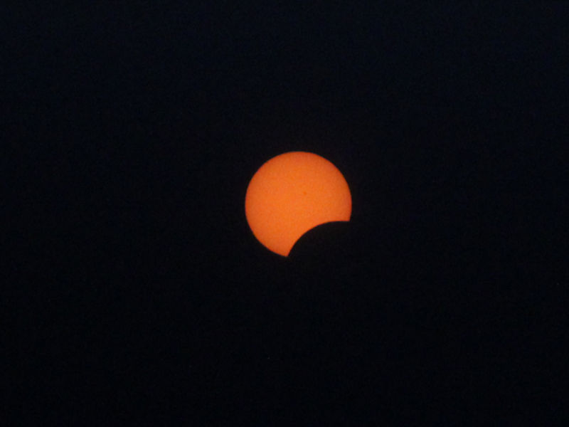
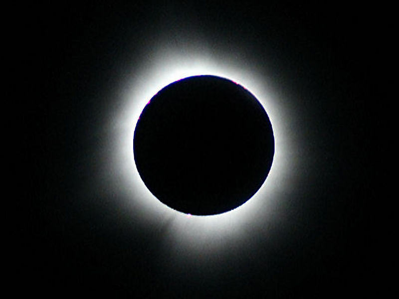
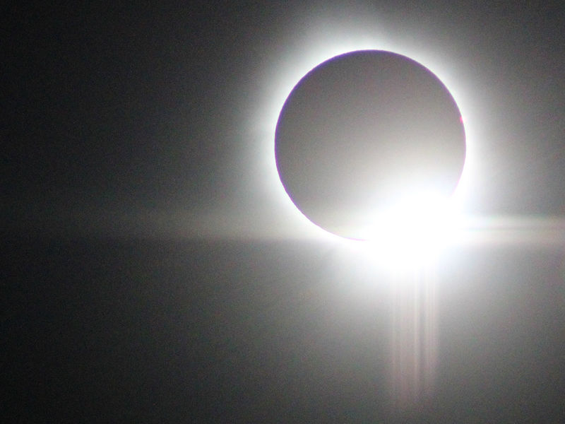
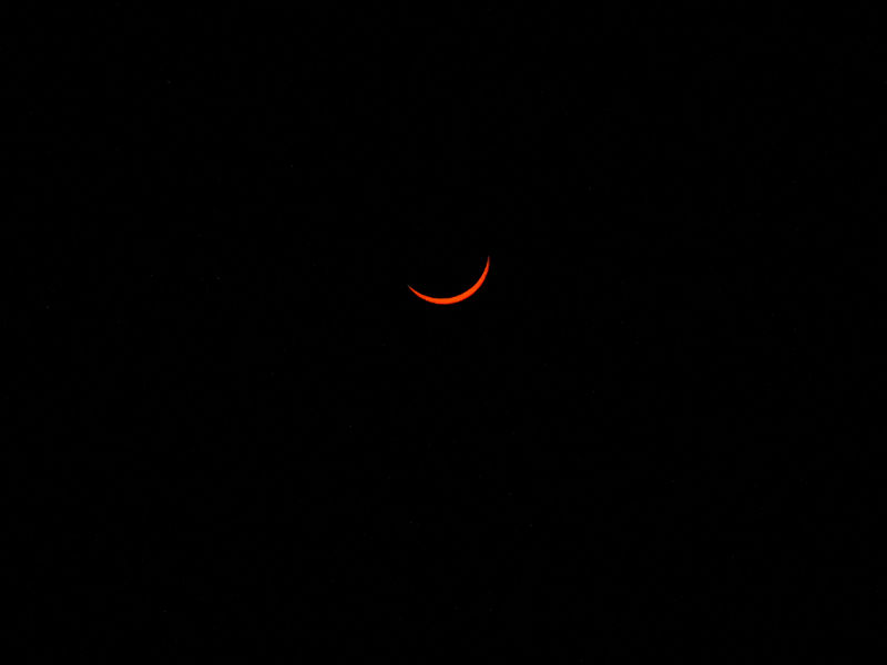
2 hours ago, donsutherland1 said:
Six photos from the April 8, 2024 solar eclipse taken at Moose River, Maine.

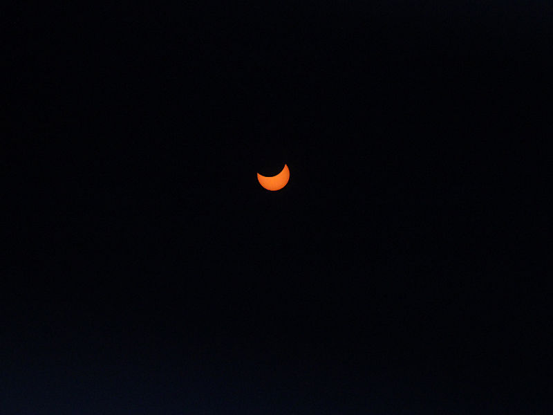
Nice.
-
3
-
-
1 minute ago, MANDA said:
They did not and I was told by an employee who was standing nearby that the store had made arrangements so that they would not. So glad they arranged for that. Honestly had not thought about that until I heard others talking about it in the hours just before it all started. Was glad when the word spread that they would not come on.
Glad to here that. The diamond ring, when the sun just made its return appearance, was phenomenal.
-
1
-
-
Spent Sunday and Monday upstate NY and Vermont, watching eclipse. Different world up there. Still snow on the ground in many areas and very little if any in the way of spring foliage. In the higher elevations going from Plattsburgh to Newport Vt. some areas had, what looked to be, about a foot of snow on the ground.
-
27 minutes ago, uofmiami said:
Ouch, glad I left Woodstock, VT at 5:30pm to head home after seeing eclipse and getting late lunch. 13 hours is brutal.
It took me 2 hours to go about 5 miles from where we saw the eclipse to the highway. I figured it would take about 2 hours to get out. I did not figure the entire length of route 91 to be so bad with traffic.
-
1
-
-
4 minutes ago, MANDA said:
Where where you in Newport? I was in the Walmart parking lot. Walmart was great to allow their parking lot to be turned into a festival atmosphere.
Totally agree with your thoughts about return trip. Vermont not able to handle that kind of mass movement of traffic. Found 91 to be a horrible road with like you said few exits and minimal if any services along the interstate itself. The few parking lots along the route turned into a large public toilets.....in the woods. Ok for us guys but felt sorry for some of the ladies.
Agree, worst traffic I have ever seen or been in. Same here just over 12 hours to get home, really closer to 14 if I account for some naps I had to take once into NY state. Same experience the first 3-4 hours were horrendous.
I was in downtown Newport area, near the high school. Nice park right on the lake. I was a little concerned about places like Walmart. I was concerned their lights would come on during totality. Hope that did not happen.
-
1
-
-
18 minutes ago, MANDA said:
Left NJ about 12:30 a.m. Monday. Hardly a car on the road the entire trip. Made it up to Newport, VT near the Canadian border in NE Vermont in just over 6 hours. Lots of time to kill priWor to event but it was a party atmosphere, tailgating, campers.
Trip home was a horror show. Better than 12 hours in total and 91 south in Vermont was a near parking Was like a badly executed hurricane evacuation. Eventually cut over to I87 near Troy/Albany and continued south from there.
Well worth the trip.
Went to Albany Sunday and from there planned to go to Plattsburgh. Do to the cloud forecast ended up in Newport Vt. also. The trip from Plattsburgh to Newport was great, little traffic and lots of snow. The eclipse was great, my second total. So worth seeing at least once. The trip back home from Newport was possibly the worse I have ever seen. Vermont cannot handle that volume of traffic. Route 91 leaves few alternative routes and not to many exits. The first 45 miles took 31/2 hours. Got home 13 hours later, close to 5a.m.
-
1
-
 2
2
-
-
I think I felt an aftershock
-
1
-
-
12 minutes ago, Stormlover74 said:
Imagine if this happened Monday during the eclipse?
Now we start hearing about the eclipse and the earthquake and the theories as to what it means so close together.
")
-
 1
1
-
-
4.8 just northeast of Lebanon NJ
-
1
-
-
Just now, Stormlover74 said:
Holy shit was that an earthquake?
I felt it olso
-
1
-
-
1 hour ago, Brian5671 said:
Anchorage is approaching their record seasonal snow of 134 inches (129 to date) that's another stat that tells you we had a ratter winter....AK always does well when we torch all winter
Add to that, this is the second year in a row that the Sierras have had above normal snowfall, first time in some 20 plus years.
-
Northern New England ski areas having great early spring. Many have had more snow in March and April than the 3 winter months combined.
-
Snowing again in the Catskills and northern half of New England.
https://www.huntermtn.com/the-mountain/mountain-conditions/mountain-cams.aspx
-
9 minutes ago, uofmiami said:
Only 33mph so far at both my stations. Wind advisory would have been fine.
Yea only 35mph here. Seems like our area really missed the worst of the storm. However, did get a little over 2 inches of rain.
-
2 minutes ago, Dan76 said:
Yes it is windy. Many airports and open locations had gusts in the 40s and 50s.
-
Rain has slowed here, almost stopped. Looks like some heavy stuff to move thru my area in about an hour, now south of Long Island.
-
Peak gust here only 35mph
-
41 degrees here, 1.77 inches of rain and winds gusting to 35mph
-
1 hour ago, bluewave said:
3 top 10 lowest snowfall seasons during the 2020s so far. Their new average for the 2020s so far is only 26.1 which is similar to what NYC averaged during earlier decades. So about 50% of what they averaged during the 2010s. Boston had 100” in only 39 days back in 2015. That 39 day total is higher than their total snowfall since January 2021 to March 2024.
Time Series Summary for Boston Area, MA (ThreadEx)
Click column heading to sort ascending, click again to sort descending.RankEnding DateTotal Snowfall Oct 1 to May 31Missing Count1 1937-05-31 9.0 0 2 2012-05-31 9.3 0 3 2024-05-31 9.7 59 4 1973-05-31 10.3 0 5 2023-05-31 12.4 0 6 1980-05-31 12.7 0 7 1995-05-31 14.9 0 8 2002-05-31 15.1 0 9 1989-05-31 15.5 0 10 2020-05-31 15.8 0
Monthly Total Snowfall for Boston Area, MA (ThreadEx)
Click column heading to sort ascending, click again to sort descending.YearOctNovDecJanFebMarAprMaySeasonMean 0.9 T 5.2 12.2 7.0 0.6 0.2 T 26.1 2023-2024 0.0 T 0.2 9.0 0.5 T 0.0 M 9.7 2022-2023 0.0 T 1.0 6.9 3.6 0.9 0.0 0.0 12.4 2021-2022 0.0 T 0.4 36.2 15.3 2.1 T 0.0 54.0 2020-2021 4.3 T 13.0 5.8 15.3 0.1 0.1 0.0 38.6 2019-2020 0.0 T 11.5 3.1 0.5 T 0.7 T 15.8
Monthly Total Snowfall for Boston Area, MA (ThreadEx)
Click column heading to sort ascending, click again to sort descending.YearOctNovDecJanFebMarAprMaySeasonMean 0.1 0.3 6.9 15.8 20.5 8.5 1.0 0.0 53.0 2018-2019 0.0 0.1 0.1 2.1 11.6 13.5 T 0.0 27.4 2017-2018 0.0 T 9.2 17.8 8.3 23.3 1.3 0.0 59.9 2016-2017 0.0 T 5.9 8.9 21.5 10.1 1.2 0.0 47.6 2015-2016 T 0.0 0.9 9.5 15.0 4.1 6.6 0.0 36.1 2014-2015 0.0 2.6 0.3 34.3 64.8 8.6 T 0.0 110.6 2013-2014 0.0 T 11.7 21.8 22.9 2.2 0.3 0.0 58.9 2012-2013 0.0 0.4 3.4 5.0 34.0 20.6 T 0.0 63.4 2011-2012 1.0 T T 6.8 0.9 0.6 0.0 0.0 9.3 2010-2011 0.0 T 22.0 38.3 18.5 1.3 0.9 0.0 81.0 2009-2010 0.1 0.0 15.2 13.2 7.0 0.2 0.0 0.0 35.7
Maximum 39-Day Total Snowfall
for Boston Area, MA (ThreadEx)
Click column heading to sort ascending, click again to sort descending.RankValueEnding DateMissing Days1 100.2 2015-03-03 0 There is little doubt that we are getting milder. However, I don't believe we are not going to see good winters still, some seem to be implying that. The above records really show we were due for a snow drought of sorts.
-
41 degrees with rain, 31mph wind gust.
-
1.35 here so far.
-
1.10 here so far.
April 2024
in New York City Metro
Posted
34 degrees for a low here. lots of places freezing or below outside the city.