

It's Always Sunny
-
Posts
1,943 -
Joined
-
Last visited
Content Type
Profiles
Blogs
Forums
American Weather
Media Demo
Store
Gallery
Posts posted by It's Always Sunny
-
-
5 hours ago, LibertyBell said:
17th I think it was a Saturday
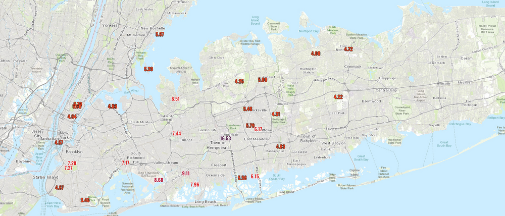
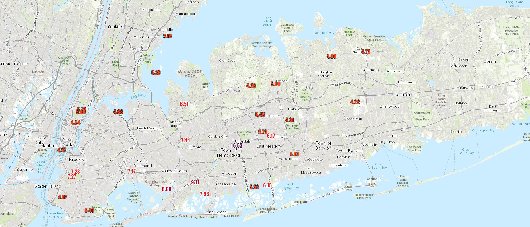
Related to Irene? If so, I am seeing 5.04" on the 27th.
-
On 10/18/2023 at 7:12 PM, LibertyBell said:
Thanks for these totals! I live right near that 9.11" total! My gage measured 9.06" so it looks like it was spot on!
Hey do you have rainfall totals from August 2011 which was JFK's previous record for all time daily rainfall? I want to see if anyone in the area exceeded these totals-- from what I can tell this storm delivered a little more than that one did!
Dates for August 2011?
-
45 minutes ago, gravitylover said:
What time are we thinking for the rain to start?
Start times have moved up a bit given shift north and more progressive system, so leaning somewhere between 10am-1pm.
-
 1
1
-
-
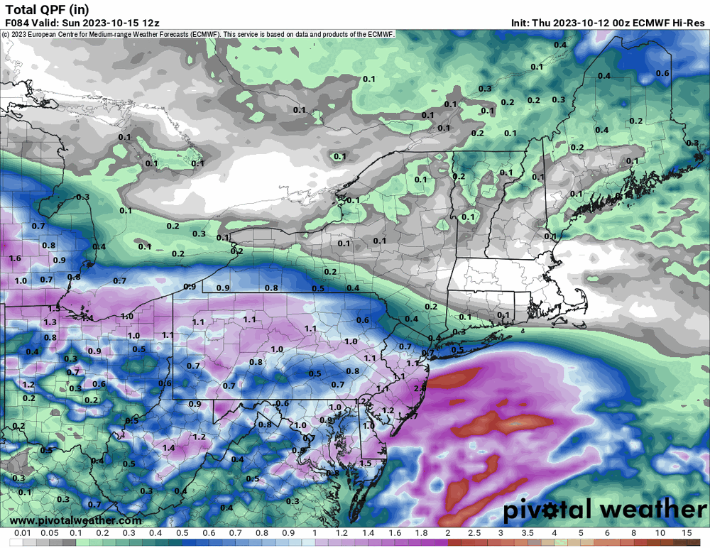
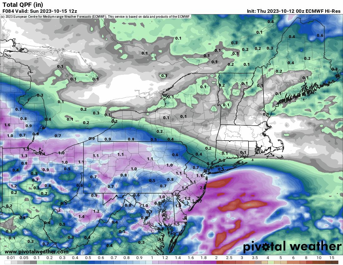
ECMWF trended north since yesterday. More in line with GFS now:
-
Hey all. I have an outdoor thing in Bethpage on Saturday. What's the thinking, dry until at least 2 or rain earlier?
High uncertainty (so good chance it will change) but it’s looking like it’ll start sometime in the afternoon.-
1
-
-
How things are shaping up for this weekend so far:
https://longislandwx.blogspot.com/2023/10/weekend-rain-october-14-15th.html -
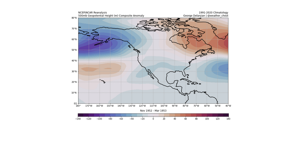
49 minutes ago, GaWx said:
In your outlook, you said:
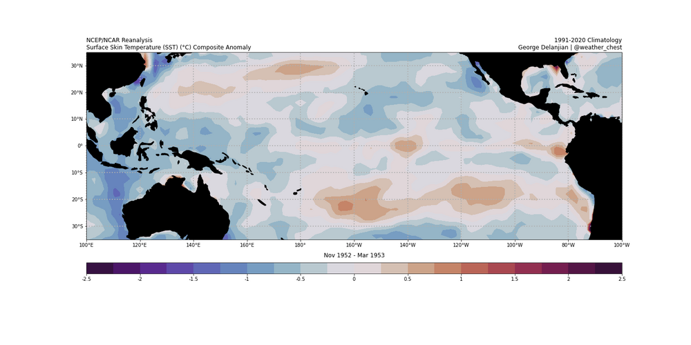
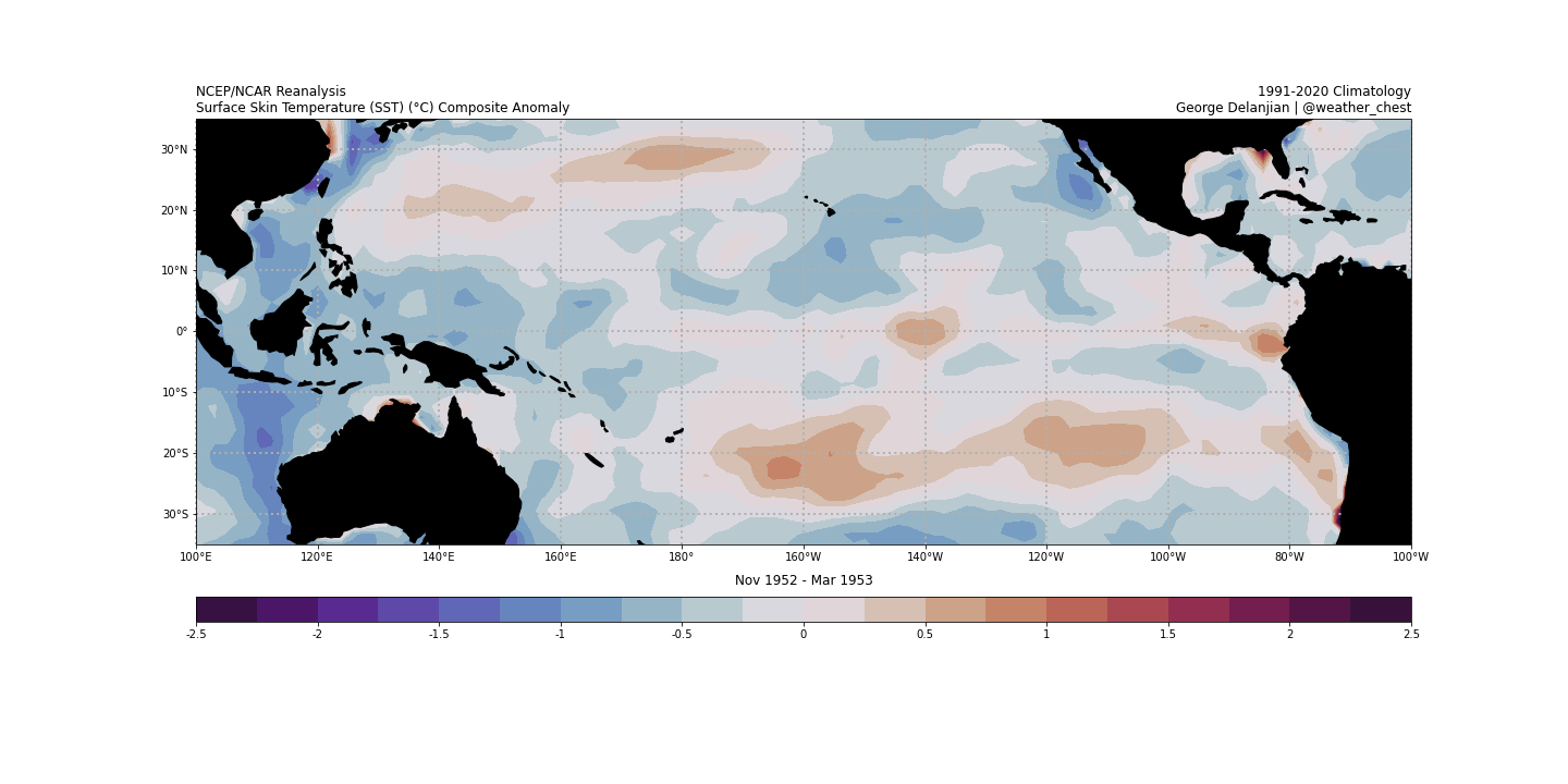
“I've decided to take a blend of 1952-1953, 1956-1957, 1972-1973 & 2009-2010.”
Also, following that, the three maps you showed included 1956-7 instead of 1957-8 (H5, temperatures, and precip) in the Nov-Mar blend calculation.
Obviously, you meant 1957-8 (strong CP El Niño), which I see you mentioned earlier several times, instead of 1956-7 (cold neutral).
Ah good catch I’ll fix that. Thank you!
-
 1
1
-
-
17 hours ago, LoboLeader1 said:
Strong El Nino favored here in the east, does not bode well for snow lovers.
Climatologically, true, but there are always other factors involved. I think coastal regions tend to struggle the most during strong El Niño events.
-
1
-
-
My preliminary winter outlook:
https://longislandwx.blogspot.com/2023/10/preliminary-winter-outlook-2023-2024.html
-
5
-
-
-
My preliminary winter outlook:
https://longislandwx.blogspot.com/2023/10/preliminary-winter-outlook-2023-2024.html
-
1
-
3
-
-
I updated my my subjective ENSO analyses on my site. I'm still in the process of updating some of the climo datasets I use to generate composites but it'll have minimal effect.
-
I updated my my subjective ENSO analyses on my site. I'm still in the process of updating some of the climo datasets I use to generate composites but it'll have minimal effect. I added ISP snowfall history for reference.
-
14 hours ago, jm1220 said:
Final totals not done yet and Suffolk still heavy rain, but this was definitely Ida for southern Nassau-some places in the 5 towns/Atlantic Beach must've gotten over 8". Widespread 5"+ elsewhere in S Nassau. I probably have 4-5", that was some of the most intense rain I've seen in quite some time. Long Beach was a "chaotic disaster" this afternoon according to my mom who had to drive in it.
36-hour Totals posted below. It was crazy here yesterday with roadways closed due to poor drainage and the gutters that are on the side of some inclined streets that feed into the main drain at lower elevations reminded me of white water river rapids. This water was absolutely gushing. I've never seen anything like it. You would've thought a water line burst with how strong the flow of water was.
-
1
-
1
-
-
1 hour ago, LongBeachSurfFreak said:
I was generalizing about the upcoming cold season. This weekends storm is pretty meh. Though it does have some upside potential if all goes right with full moon tides.
I agree about this weekend's storm being meh considering it moves inland, gets sheared and we're left with its remnants. ECMWF on the other hand keeps it riding mainly along the coast, resulting in higher rain totals. It's kind of funny how much uncertainty remains considering it's only a couple days out.
-
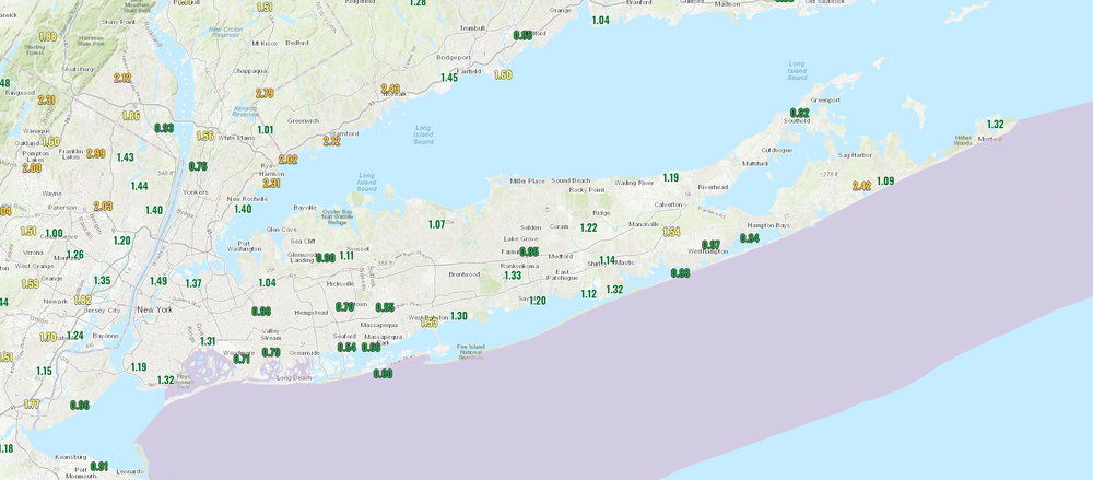
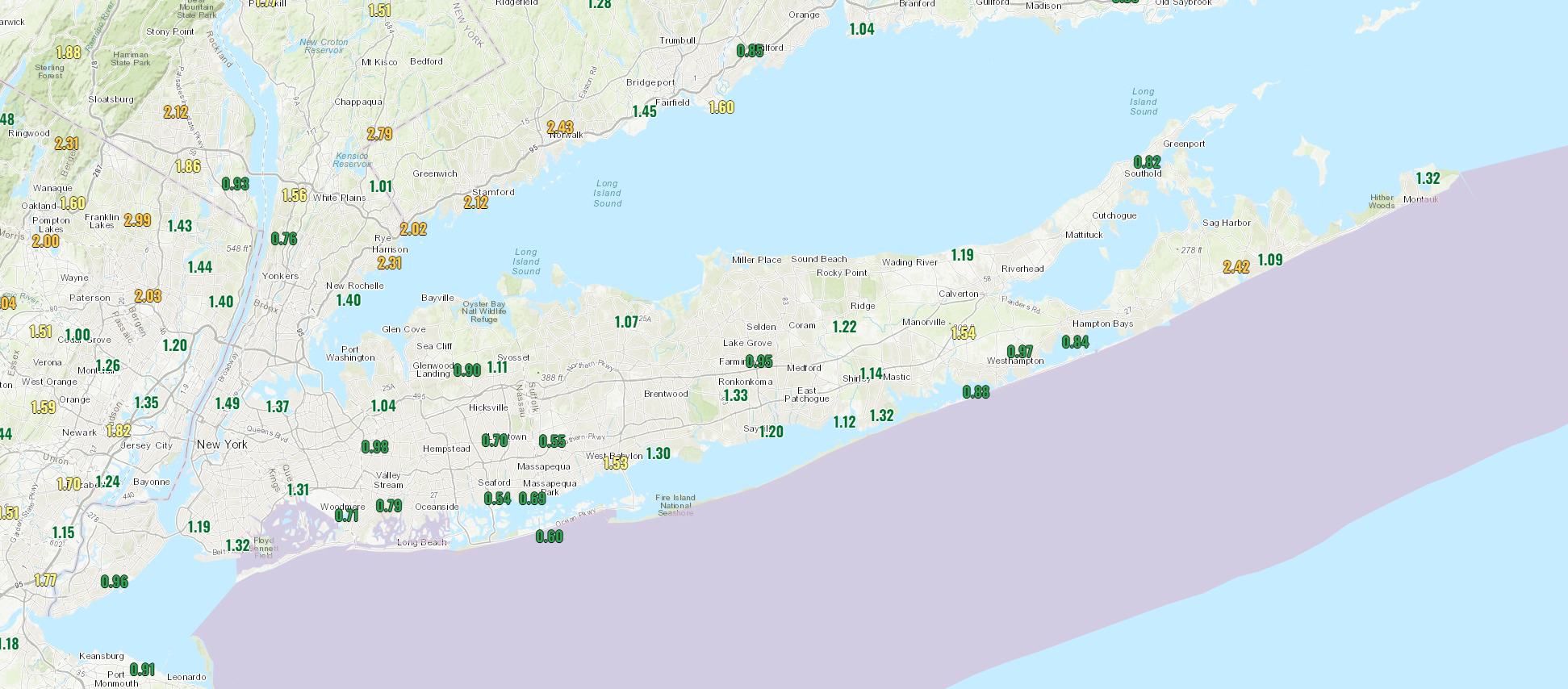
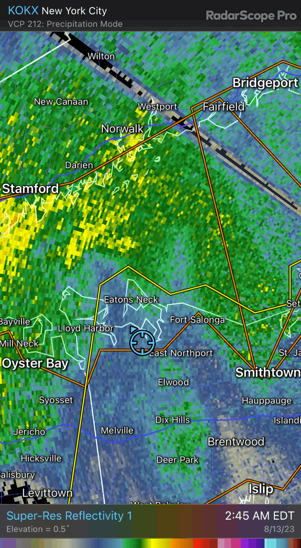
Some good rain totals across Long Island since last evening. Lots of locations reporting above (or at least near) 1".
-
I think we'll get above average snowfall, but not the least influenced by the Farmer's Almanac.
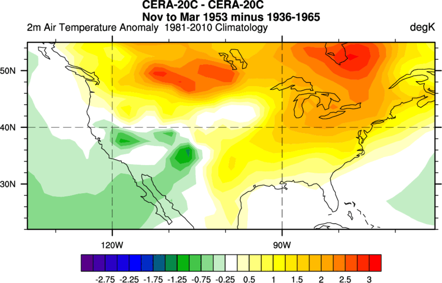
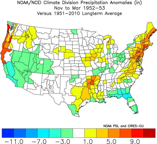
There will be many different dynamics in play, but foundationally we are looking at a strengthening, east based El Nino. The only composite that I have recorded that meets that criteria is 1952-1953 which ended up finishing with above normal snowfall for much of the Northeast U.S. I'm sure others will chime in that additional years meet that criteria but nonetheless I think signals will point to an active winter. Time allowing, I would like to put out a seasonal forecast to see how it compares this this analog. NYC reported between 13-15" of snowfall that winter.
-
2
-
-
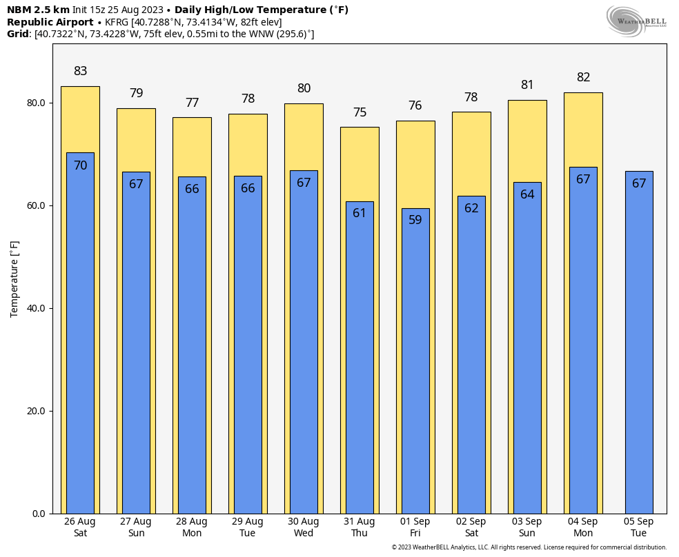
Islip & Farmingdale hit 90F today. Warmest September temps since 2018!
-
Pattern change on the way later this week:
https://longislandwx.blogspot.com/2023/09/northeast-us-pattern-change.html
-
Brief cool down on the way next week...will be the first time most of Long Island (and NYC for that matter) drop below 60F since June 22nd.

-
Histogram of dew points YTD for ISP...definitely muggier than normal:

-
1
-
-
Hell of a light show!

-
1
-
-
22 hours ago, jm1220 said:
Insane how the S Fork has done so well this summer. They’re almost always the dry spot in the marine influence while up here toward the city gets more near the sea breeze fronts. I had maybe 0.3 or so here.
Yeah it’s an interesting microclimate feature for sure. I’m surprised we got more rain here a few days ago with that little cell compared to this event. On a separate note, just got a good downpour here a short time ago.
-
1
-
-
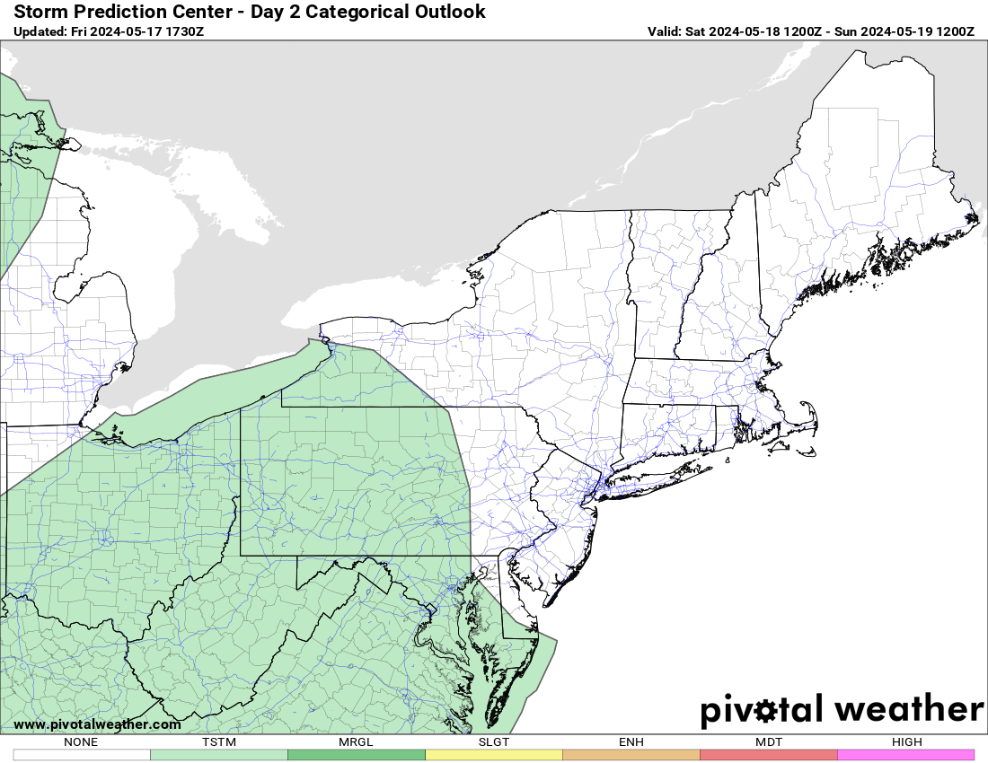
Half of LI upgraded to a Slight tomorrow:

Long Island Weather
in New York City Metro
Posted
Long Island Weather: End of Month Pattern Change & Polar Vortices Explained (longislandwx.blogspot.com)