TravisWx
-
Posts
94 -
Joined
-
Last visited
Content Type
Profiles
Blogs
Forums
American Weather
Media Demo
Store
Gallery
Everything posted by TravisWx
-
Interesting. Wasn't aware of this criteria. Thanks!
-
APX just posted WWA's for essentially their entire coverage area. Surprised no WSW for counties east of I-75.
-
About 6-8” in Rogers City with drifts. Very fluffy, so cleanup should be easy compared to this past Tuesday.
-
I agree. This will likely be a big bust for Presque Isle County as well. I’m sure they’ll be some bigger drifts as it is very windy. But overall accumulation is going to be far lower than what was forecast. You’re right, it does look like the main batch of organized moisture is already past us. Maybe a few inches of lake effect tomorrow and Sunday. I’d say by the end of the weekend, total accumulation for Rogers City will be around 6-8” Sent from my iPad using Tapatalk
-
Moisture appears to be winding down quickly. APX knocking down snow totals a bit. Sent from my iPad using Tapatalk
-
Already getting some lake enhancement in Rogers City due to the E/ESE wind. Started snowing around noon, winds really ramping up now.
-
From APX. Topped off my gas can for the snowblower this evening. Locals already hitting the grocery stores heavy in anticipation of this weekend storm.
-
About 5" of concrete snow in Rogers City. Pressure bottomed at 979.5Mb at 1AM, according to my weather station.
-
Intense snowfall right now in rogers city. Pressure: 982mb Temp: 30.6°
-
Temps slowly drifting lower. Had some initial fluffy snow around 10:30am for a half hour. Then transitioned to light rain. Heavy band of snow knocking on the door now, should be here within an hour.
-
Finally starting to see some snowfall in Rogers City as of 10:25AM
-
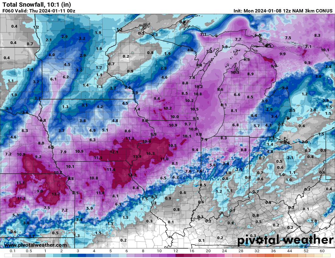
It does look like that precip moved SE on the 12z 3km NAM, a little more amped too for total snowfall. I don't know though. This winter storm is weird. APX still says almost nothing for snowfall. Definitely a nowcast system.
-
Radar is starting to fill in around NE MI. Don't see any precip falling in Rogers City yet this morning. Current temp: 35 degrees, east wind 3-4 mph.
-
From APX: Looks like I won’t even have to break out the snowblower. Maybe 1-2” for Rogers City. Sent from my iPad using Tapatalk
-
APX with a WWA for my area
-
NE lower MI still appears like it's going to take the brunt of the snowfall this storm. 3km NAM 12z
-
It looks like this will be the first large winter storm for northeast lower MI...for now. I raked up the residual autumn leaves in my front yard around Xmas, first time ever. Haven't touched a snow shovel since last winter.
-
Seems like a solid snow maker for Rogers City in NE lower MI. Already getting lake enhancement off Lake Huron.
-

Pre-Christmas (Dec 21-23rd) Winter Storm Part 2
TravisWx replied to Chicago Storm's topic in Lakes/Ohio Valley
I have 996mb on my Tempest weather station in Rogers City, MI -
Pre-Christmas (Dec 21-23rd) Winter Storm Part 2
TravisWx replied to Chicago Storm's topic in Lakes/Ohio Valley
Started snowing here in Rogers City (35 miles north of Alpena) about 15 minutes ago. -
Pre-Christmas (Dec 21-23rd) Winter Storm Part 2
TravisWx replied to Chicago Storm's topic in Lakes/Ohio Valley
Will do. I plan on posting images and video during/after the system. -
Pre-Christmas (Dec 21-23rd) Winter Storm Part 2
TravisWx replied to Chicago Storm's topic in Lakes/Ohio Valley
Yeah I meant to type northern lower peninsula. -
Pre-Christmas (Dec 21-23rd) Winter Storm Part 2
TravisWx replied to Chicago Storm's topic in Lakes/Ohio Valley
APX just upgraded headlines. Majority of the northern lower peninsula is under a blizzard warning. -
Pre-Christmas (Dec 21-23rd) Winter Storm Part 2
TravisWx replied to Chicago Storm's topic in Lakes/Ohio Valley
APX should be adjusting headlines momentarily. -
Pre-Christmas (Dec 21-23rd) Winter Storm
TravisWx replied to Chicago Storm's topic in Lakes/Ohio Valley
12z GFS still looking good for NE lower MI. I'll take it.