

n1vek
-
Posts
232 -
Joined
-
Last visited
Content Type
Profiles
Blogs
Forums
American Weather
Media Demo
Store
Gallery
Posts posted by n1vek
-
-
12 minutes ago, ValpoVike said:
12z HRRR is ticking up for Denver and points north by an additional .5", and an additional 1" in the foothills.
Does anyone have any ideas on why the Para GFS is outputting lower QPF in the foothills than those down along the urban corridor? Quite odd.
Nice to see the HRRR coming onboard. Just going to have to watch the radar fill in today. And I guess any southward trend (even 15-25 miles) will make a big difference locally.
-
@Ji - It is oddly quiet. I lurked/posted occasionally on the Great Lakes forums while living in Michigan and would cheer on the NE during their big events. Not sure if there is another place everyone is landing to discuss weather in this region.
The standard deviations from the mean of some of those GFS runs would've crashed the website if an equivalent storm was heading for the i95 corridor.
-
 1
1
-
-
Just now, AlaskaETC said:
The 18z GFS definitely isn't kind to the Denver area.
Saw that tweet yesterday about how the current operational GFS is being put to pasture shortly anyways. I guess we can ride the Para GFS for now (depending on if it is more favorable for my backyard, of course).
-
Most of the point-and-click forecasts have trended in the wrong direction today. It feels like this guy is going to limp across the finish line in the metro area. Still will be a nice storm, but nothing like the hype some Facebook posts kicked off on Monday posting one crazy GFS run.
-
These mesoscale models are not really playing ball as of quite yet.
-
6 minutes ago, smokeybandit said:
0z GFS basically gives no precip at all, rain or snow, east of 25
GFS is on a spirit quest right now.
-
14 minutes ago, smokeybandit said:
NAM doesn't seem overly impressed by the storm.
Not to discount the NAM, but the surface low per the maps is just wonky practically sitting over Steamboat. (This is me wishcasting)
-
1 minute ago, ValpoVike said:
Be sure to get food, or stay very close to downtown. I wouldn't want to walk or drive this weekend. None of the hotels have restaurants except the Stanley, but rooms there are $$$$. But it has a big tie into The Shining, which may be a good mood setter for an epic snowstorm. Let's avoid more in the thread, and PM if you have questions.
+1 for staying at the Stanley if you can swing it. Place is awesome.
-
2 minutes ago, Wentzadelphia said:
Thank you. Now when it comes to elevation vs not being in the complete sticks is there any specific town near there that I should look fo? For example looking at that WRF image above I’m guessing those 40” plus amounts are up in the mountains?
I would try and stick around Boulder. Getting up and down the canyon roads might be incredibly really tough. Otherwise maybe Ward or Nederland would be a great place to get snowed in.
-
13 minutes ago, Wentzadelphia said:
Hey guys looks like I’m flying out there tomorrow. Gonna figure out the complete logistics tonight. Last second decision as always haha. Should be fun. I’ve gotten some recommendations for spots so far (any state)...would appreciate any more. I need to find a place relatively close to an airport. I just chill at a hotel. Gonna need a gas station, rent a car, and WiFi and I’m all set ha
Rent a snowmobile.
-
1
-
-
This is when it gets fun. Now we wait for the next run of the Euro. See who blinks first. Or we go into nowcast-time with the GFS dropping 80" in RMNP

-
12z GFS operational really wraps in some warm air north of the surface low. Obscene snow totals for the higher elevations, but that warm tongue creates a crazy, elevation dependent, gradient up near Fort Collins. As noted above, QPF is still off the charts for both the operation and ensembles.
-
Given the audacity of the GFS, gotta assume it caves at least somewhat to the rest of the model consensus.
-
1 hour ago, smokeybandit said:
NWS already dropping their amounts east of I-25 even as the Euro holds serve and the GFS ticks south again
Agreed - GFS southernly trend is there comparing runs this morning. I don't have access to Euro maps, but hopefully OpenSnow posts some views this morning.
-
15 minutes ago, skierinvermont said:
Eyeballing it looks like the Euro ups the metro from around 1.5" to 1.9". Decent ~50 mile southward shift in the overall QPF field. And the 500mb looked closer to the GFS than it did before. Still need another 50-75 miles south shift to really focus the upslope over the NW metro area.
I'll be very interested to see how this all models out in the next 12 hours with everything onshore. I could handle a little walk further south. NWS seems pretty good based on their afternoon AFD with that 2-3" qpf range in the metro. Ratios, daytime sun angle may also be a story watching how effectively this will accumulate. That being said, I'll take the moisture however we can get it!
-
Moved to Denver over the summer, but wanted to check in on the Great Lakes crew getting their first storm of the year. Enjoy it guys.
-
2
-
-
5" in my point-and-click for Royal Oak, MI. Is that a typo?
-
Just went out for a drive. A lot more snow than I had expected. I think 3-4" is pretty conservative. Lines up with DTX/MIStorm97.
Stebo/SE Michigan crew, up stream is looking pretty good. Is that going to hold together for another wave?
-
This band over SE Michigan right now has to be approaching max rates I've experienced.
-
1
-
-
Pretty impressive flake size here in Royal Oak. Looks like we may be 10 miles from a nice 6"+ storm. Right on the edge. Downtown Detroit is lined up for ~3.5" where as the northern burbs may end up with 8". Its a tough storm to be on the southern extent considering how broad the swath of meaningful snow is north of here.
-
1
-
-
It's been incredible watching the radar over 696 refuse to fill in this morning. Sucker hole.
-
 1
1
-
-
7 minutes ago, ILSNOW said:
GFS not backing down
Lock it in.
-
Nothing model specific, but locally it is interesting DTX has been riding a 4" call and TWC hasn't budged from their 5-8" call in days.

-
2
-
-
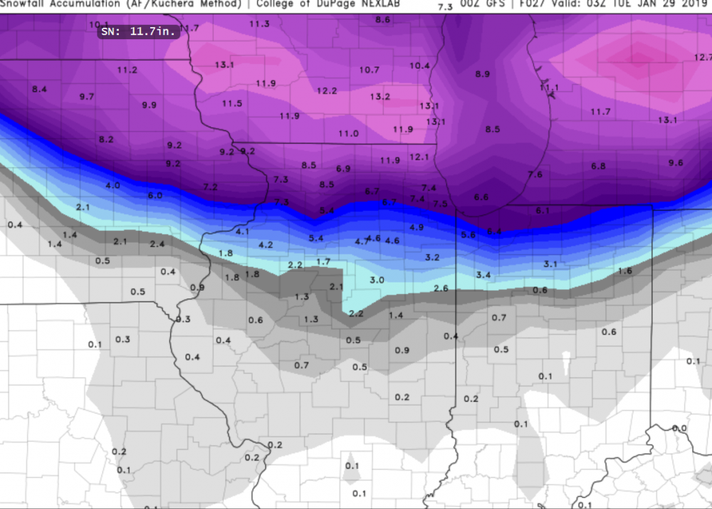
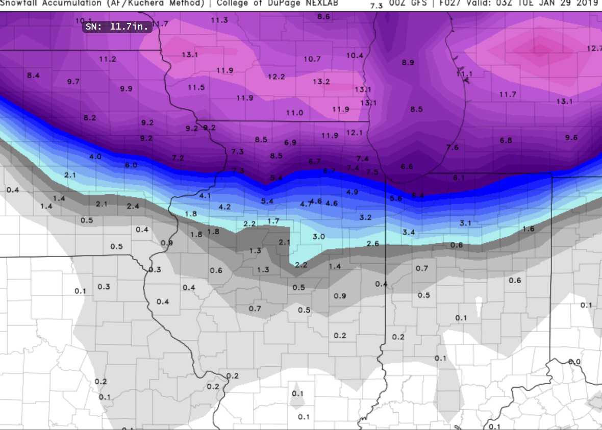
The GFS precip field seems to hold together much further east vs the recent NAM runs.
Mountain West Discussion
in Central/Western States
Posted
Had a little graupel earlier in the Highlands. Now its a misty/rainy kind of mix. Waiting on the more intense bands to roll through and get the show started.