

mackerel_sky
-
Posts
16,047 -
Joined
-
Last visited
Content Type
Profiles
Blogs
Forums
American Weather
Media Demo
Store
Gallery
Posts posted by mackerel_sky
-
-
Just now, griteater said:
For the zone from the far northern upstate thru northern Mecklenburg country (north Charlotte) thru Raleigh, it's simply a tough call. The near surface above freezing layer is very shallow. Good, steady precip could knock the surface temperatures right down to 32-33...and with cold air pouring in to the system aloft right as the precip gets going good, any warm nosing there could get mitigated. Good luck to all!
Latest future radar on WYFF, has a quicker transition to snow! About 11AM it makes it to 85, about 2 hours earlier than last run! If we get any help, hour or two of clearing, maybe lower DPs, anything would help! Watching rain and waiting for changeover, is tough!
-
 7
7
-
-
4 minutes ago, David Johnson said:
Up’d the totals some from GSP
.Like the “ highly subject to change “ part! I’m hoping for some clearing and lower temps than forecast! Supposed to be 40/41 at onset!
-
2
-
-
Not even a WWA here!
-
2 minutes ago, oconeexman said:
Lol I guarantee Landrum gets snow
TR gets 4”+, no school Friday Greenville County, calling it now!
-
1
-
 1
1
-
-
2 minutes ago, lilj4425 said:
Which one?
Fox Carolina
-
 1
1
-
-
4 minutes ago, burrel2 said:
Pickens county close to Clemson.
Future radar has it ripping snow, even S of 85, by 2pm! In Upstate
-
3
-
-
Just now, WarmNose said:
Motel 6 in Landrum still got any availability?
They left a light on for you, to watch for flurries
-
 1
1
-
-
Just now, WarmNose said:
GSP must have read Grit’s forecast just before pulling the plug

Currently a snowy 54 degrees
-
1
-
-
Looking at WRF and HRRR, wreaks of desperation
-
1
-
-
11 minutes ago, thess said:
It's been a while for me. When is the time it usually all falls apart for us? Is it the late night runs tonight?
Yesterday
-
1
-
1
-
-
4 minutes ago, lilj4425 said:
Just put us out of our misery already. I’m tired of waiting.
Just watch Dale Gilbert
-
1
-
-
My local forecast on TWC app has less than an inch for tomorrow this morning, now says 1-3”!
-
2
-
-
16 minutes ago, Iceagewhereartthou said:
For the upstate peeps, this one just isn't for us. Typically we suffer the "cold chasing moisture" syndrome and this is going to be on full display tomorrow. We may see a quick mix or full changeover at the end but it just is what is. Eastern upstate could well get in on a couple inches but the cold just isn't there for most. Going to be hard watching all of NC get a solid snow and eastern sections with the big dog, but c'est la vie for us.
But we e got the SREF on our side!

-
1
-
-
Just now, sarcean said:
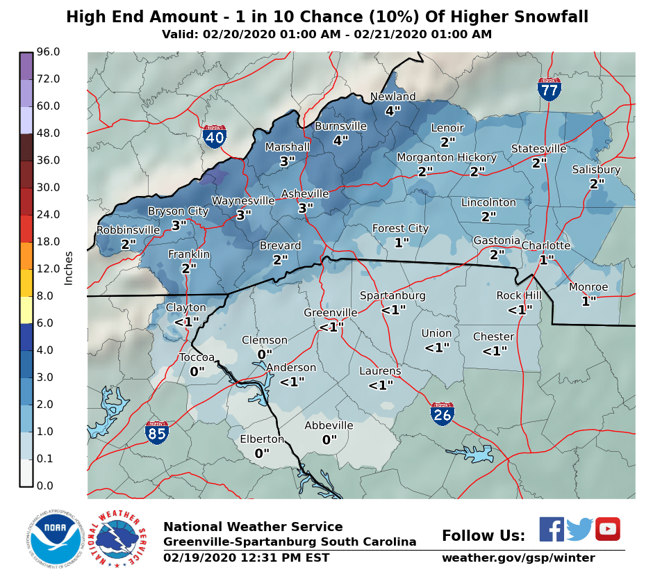
GSP is being very conservative...when the high amount (1 in 10 chance is only 1" still for Charlotte

That’s a lot bolder than the morning update this AM, which had zero!
-
2
-
-
NAM is reliable for warm noses
-
1
-
-
But the NAM is the new king!

-
1
-
1
-
-
Don’t us global less than 24 hours out, go with hi res mesoscale models
-
1
-
-
Robert mentions thunder possible tomorrow from ATL,CAE, to CLT in his latest post on FB!
-
1
-
-
It died in the main thread! Looks like Rob still going with tree crushing snows, everywhere except S.C. on his latest FB post!

I love getting sleet at 37 degrees! Roads will be a disaster down here tomorrow!

-
The NAM love ended real quickly!
-
1
-
 1
1
-
-
14 minutes ago, lilj4425 said:
GSP says you get nothing and you like it too.
I like how they said” future model runs could result in issuance of wwa, “ ooooooh, exciting
-
Just now, lilj4425 said:
GSP and RAH discussion really made the place die out. Lol.
Yeah, it’s very quiet in here , with RAH getting 12” plus! Waiting to get RAP’d
-
Being 57 degrees currently, should help! The cold air always arrives over the mountains sooner than expected!
In all seriousness, this is the most bullish I’ve ever seen Nicole P be on snow -
27 minutes ago, lilj4425 said:
If it snows 2 inches here I will sell my kidney to a homeless man.
Prep for surgery!
Southeast Sanitarium - A Place to Vent
in Southeastern States
Posted
Is there a sim radar for this?