

hawkeye_wx
-
Posts
5,933 -
Joined
-
Last visited
Content Type
Profiles
Blogs
Forums
American Weather
Media Demo
Store
Gallery
Posts posted by hawkeye_wx
-
-
Thankfully, the storms sank far enough south overnight to get Cedar Rapids. I picked up 1.23". I had only received 0.31" over the last 16 days and the next ten days look dry, so this is much-needed.
-
The drought region of southern Iowa hit the mid to upper 90s this afternoon. We surged to about 90(dew of 74) once the earlier storms moved out, but more storms and clouds have moved in. DVN has become more bullish on storms and heavy rain sinking farther south tonight than what models have been showing(models have missed all the storms in Iowa today). I hope that pans out because it is becoming dry here, and it may not rain again through day 10 once tonight is over.
-
The CAMs totally whiffed on the severe storms with 60-80 mph wind tracking from Nebraska through southeast Iowa today. There are many reports of trees down as they tracked south of Des Moines.
-
I picked up over an inch of rain from the first cell. The next cell just blew up to my west and a warning has been issued for CR.
-
Another tornado warning just west of CR, but doesn't look like it'll amount to much, like the first one earlier.
-
Woo! It's not severe, but we're getting very heavy rain, with a bit of wind and a bit of pea size hail, and it's last for a while this time, not five minutes like every other cell this spring.
-
 1
1
-
-
So far it has been a lot of lightning and a constant low rumble here in CR. The action has been one county west, while the weakening blowoff rain moves east into CR.
-
Tornado warning west of Cedar Rapids.
-
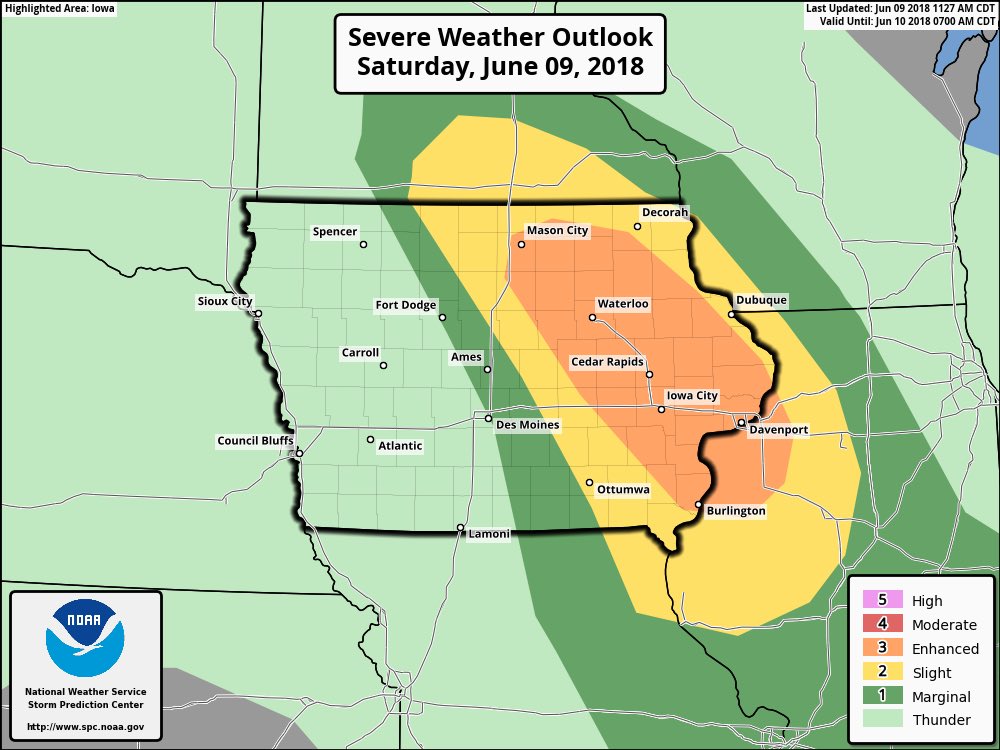
SPC has upgraded eastern Iowa to "Enhanced" severe chance tonight. The CAMs are consistently showing the MCV up in Minnesota refiring late this evening and diving southeast across eastern Iowa, with wind damage potential I'm sure. This may be my best chance of a good storm all spring.
-
There's a bunch of big stuff from just west of Cedar Rapids over to central Iowa. It is expected to dive south and miss CR. It has been one of those years in which all the big stuff avoids my yard. However, my garden could certainly do without the 70 mph wind and golfball size hail being reported.
-
57 minutes ago, cyclone77 said:
Pretty benign looking pattern for meaningful severe for the foreseeable future. Hopefully June makes up for a very meh May.
It has been an incredibly boring storm season in my yard. Some locations have had good storms, but there has been nothing widespread, leaving some of us with very little.
-
Getting missed north and south has been the theme so far this month around here. This morning's storms mostly missed south. I got a quarter inch of rain.
-
The recent Mt. Agung eruption was a mouse fart. I doubt it could have affected the weather/climate.
-
10 minutes ago, cyclone77 said:
Well one positive thought about this never-ending winter of 2018, looks like we'll be hacking off about a month of the mowing season. Maybe we'll get lucky and also skip over the ghastly dandelion season as well.
I'm hoping the honeysuckle aphid season will be less destructive. They show up when it warms consistently and the honeysuckle vine leafs out, then vanish when it gets hot in June. A shortened spring should help.
-
I planted my first tulips last November. They just emerged from the soil this morning.
-
2
-
-
I agree with NWLinn. This storm raises this winter to a B. My snowfall total is now a bit above avg, we had two solid clippers, and now this storm with all the thunder/lightning, 8" of snow, and strong wind.
-
1
-
-
That's some pretty awesome stuff you guys are reporting/photographing. Half those rates/totals would be a dream storm here in Iowa. Around here, >foot totals are next to impossible and even ten-inch storms are rare. Four inches counts as a good storm. It's the ultimate nickel-dimer climate. OceanStWx used to work here at DVN, so he knows how pathetic this area can be.
-
The last four runs of the Euro are showing something interesting in the 6-10 day period... possible tropical storm or typhoon formation in the Gulf of Thailand.
-
Pressure is up to 917 mb. While the outer eyewall is trying to take over and is looking more robust with time on radar, I think the timing of the replacement cycle is about as favorable as Puerto Rico could have hoped for. PR would be worse off if the cycle had begun 8-12 hours earlier.
-
2
-
-
The latest euro still takes Maria out to sea, but models are still inconsistent with Jose's future track/strength/influence.
Latest recon pass suggests a pressure of about 914 mb, and the max wind has come down a fair amount as the inner eyewall's energy is gradually transferred outward. The max SFMR on the last pass was 132 mph. I think the official 165 mph status is generous at this point.
-
175 mph SFMR wind, unflagged.
-
2
-
-
17 minutes ago, olafminesaw said:
Roseau looks like it will sustain a direct hit. It's hard to imagine what it's going to feel like for those people expecting a possible category 3 as of this morning.
Earlier this afternoon, a significant nw jog had me thinking the northern/northeastern coast was in the biggest trouble, and perhaps the capital in the sw would escape the worst, but an equally-big west jog has taken the eye right into the south half.
-
Recon is in the air, although they are flying in from Curacao so it'll take a while to reach Dominica.
-
In addition to the obvious core bombing today, there has been a significant expansion of outflow to the south and west as the Caribbean upper low's influence has waned.
-
1
-
August 2018 General Discussion
in Lakes/Ohio Valley
Posted
Cedar Rapids got hit pretty good this evening. I picked up 1.60" of rain, while the north to northeast side received 3+".