

mahantango#1
-
Posts
5,058 -
Joined
-
Last visited
Content Type
Profiles
Blogs
Forums
American Weather
Media Demo
Store
Gallery
Everything posted by mahantango#1
-

Central Pa. Summer 2024
mahantango#1 replied to mahantango#1's topic in Upstate New York/Pennsylvania
In today's society people need to get the message. Hopefully they do. The NWS can't be clearer on this event. I hope it it doesn't come to what they're saying in the post. -
Central Pa. Summer 2024
mahantango#1 replied to mahantango#1's topic in Upstate New York/Pennsylvania
This forecast looks bleak for the south-east US. STORM SURGE WARNING NWS CHARLESTON SC 512 AM EDT MON AUG 5 2024 SCZ052-051715- /O.CON.KCHS.SS.W.1004.000000T0000Z-000000T0000Z/ 512 AM EDT MON AUG 5 2024 Tidal Berkeley- ...STORM SURGE WARNING REMAINS IN EFFECT... ...TROPICAL STORM WARNING REMAINS IN EFFECT... * LOCATIONS AFFECTED - Daniel Island - Red Bank Landing - Cainhoy * WIND - LATEST LOCAL FORECAST: Below tropical storm force wind - Peak Wind Forecast: 15-25 mph with gusts to 35 mph - THREAT TO LIFE AND PROPERTY THAT INCLUDES TYPICAL FORECAST UNCERTAINTY IN TRACK, SIZE AND INTENSITY: Potential for wind 39 to 57 mph - The wind threat has remained nearly steady from the previous assessment. - PLAN: Plan for hazardous wind of equivalent tropical storm force. - PREPARE: Efforts to protect property should now be underway. Prepare for limited wind damage. - ACT: Act now to complete preparations before the wind becomes hazardous. - POTENTIAL IMPACTS: Limited - Damage to porches, awnings, carports, sheds, and unanchored mobile homes. Unsecured lightweight objects blown about. - Large tree limbs broken off. A few trees snapped or uprooted, but with greater numbers in places where trees are shallow rooted. - Some roads impassable due to debris, particularly within urban or heavily wooded locations. Hazardous driving conditions on bridges and other elevated roadways, especially for high profile vehicles. - Isolated to scattered power and communications outages. * STORM SURGE - LATEST LOCAL FORECAST: Life-threatening storm surge possible - Peak Storm Surge Inundation: The potential for 2-4 feet above ground somewhere within surge prone areas - Window of concern: Begins this evening - THREAT TO LIFE AND PROPERTY THAT INCLUDES TYPICAL FORECAST UNCERTAINTY IN TRACK, SIZE AND INTENSITY: Potential for storm surge flooding greater than 3 feet above ground - The storm surge threat has remained nearly steady from the previous assessment. - PLAN: Plan for life-threatening storm surge flooding of greater than 3 feet above ground. - PREPARE: Evacuation efforts and flood preparations should soon be brought to completion before conditions become unsafe. - ACT: Leave immediately if evacuation orders are given for your area to avoid being cut off from emergency services or needlessly risk lives. - POTENTIAL IMPACTS: Significant - Areas of inundation of saltwater along immediate shorelines and in low-lying spots farther inland near rivers and creeks, with storm surge flooding accentuated by waves. Damage to several buildings, mainly near the coast. - Sections of near-shore escape routes and secondary roads become weakened or washed out, especially in normally vulnerable low spots. - Moderate to major beach erosion with heavy surf breaching dunes. Strong and numerous rip currents. - Minor to moderate damage to marinas, docks, boardwalks, and piers. Several small craft broken away from moorings, especially in unprotected anchorages. Some navigation aids possibly displaced well off station, creating difficult navigation near inlets and waterways. * FLOODING RAIN - LATEST LOCAL FORECAST: Flood Watch is in effect - Peak Rainfall Amounts: Additional 18-24 inches, with locally higher amounts - THREAT TO LIFE AND PROPERTY THAT INCLUDES TYPICAL FORECAST UNCERTAINTY IN TRACK, SIZE AND INTENSITY: Potential for extreme flooding rain - The flooding rain threat has remained nearly steady from the previous assessment. - PLAN: Emergency plans should include the potential for extreme flooding from heavy rain. Evacuations and rescues are likely. - PREPARE: Urgently consider protective actions from extreme and widespread rainfall flooding. - ACT: Heed any flood watches and warnings. Failure to take action will likely result in serious injury or loss of life. - POTENTIAL IMPACTS: Devastating to Catastrophic - Extreme rainfall flooding could prompt widespread rescues. As event unfolds, rescues could become impossible. - Rivers and tributaries could overwhelmingly overflow their banks in many places with deep moving water. Small streams, creeks, canals, and ditches may become raging rivers with strong currents. Flood control systems and barriers could become stressed or overwhelmed. - Flood waters will enter many structures within multiple communities, some structures becoming uninhabitable or washed away. Flood waters could render escape routes impassable. Streets and parking lots become rivers of raging water with underpasses submerged. Driving conditions become impossible and life threatening. Widespread road and bridge closures with most weakened or washed out. - Drinking water and sewer services could be negatively impacted. - Hazardous containers and materials could possibly be present in flood waters. * TORNADO - LATEST LOCAL FORECAST: - Situation is favorable for tornadoes - THREAT TO LIFE AND PROPERTY THAT INCLUDES TYPICAL FORECAST UNCERTAINTY IN TRACK, SIZE AND INTENSITY: Potential for several tornadoes - The tornado threat has remained nearly steady from the previous assessment. - PLAN: Emergency plans should include the potential for several tornadoes with a few possibly intense having larger damage paths. - PREPARE: Those living in manufactured homes or on boats should prepare to relocate to safe shelter before hazardous weather arrives. - ACT: Listen for tornado watches and warnings. If a tornado warning is issued, be ready to shelter quickly. - POTENTIAL IMPACTS: Significant - Isolated to scattered tornadoes can hinder the execution of emergency plans. - Scattered locations could experience enhanced damage due to tornadoes with a few spots of considerable damage, power loss, and communications failures. - Scattered locations could realize roofs torn off frame houses, mobile homes demolished, boxcars overturned, large trees snapped or uprooted, vehicles tumbled, and small boats tossed about. * FOR MORE INFORMATION: - https://weather.gov/chs - https://ready.gov/hurricanes LAT...LON 3305 7986 3299 7985 3296 7986 3293 7982 3292 7982 3291 7984 3288 7985 3287 7987 3287 7989 3287 7989 3286 7989 3283 7990 3282 7991 3282 7993 3285 7994 3286 7997 3289 7997 3291 7995 3291 7998 3293 8000 3298 8000 3302 8000 3307 7997 3307 7985 3305 7986 -
Central Pa. Summer 2024
mahantango#1 replied to mahantango#1's topic in Upstate New York/Pennsylvania
-
Central Pa. Summer 2024
mahantango#1 replied to mahantango#1's topic in Upstate New York/Pennsylvania
-
Central Pa. Summer 2024
mahantango#1 replied to mahantango#1's topic in Upstate New York/Pennsylvania
I'm glad to see that about everyone is putting Pillow in their crosshairs. -
Central Pa. Summer 2024
mahantango#1 replied to mahantango#1's topic in Upstate New York/Pennsylvania
That will be catastrophic flooding for a lot of people. -
Central Pa. Summer 2024
mahantango#1 replied to mahantango#1's topic in Upstate New York/Pennsylvania
Nice to see you keep your favorite metoroligst picture on your nightstand accessible for posting. -
Central Pa. Summer 2024
mahantango#1 replied to mahantango#1's topic in Upstate New York/Pennsylvania
I wish the people in the southeast US the best i this storm> I seen Hilton Head Island could get 26 inches of rain. I love Hilton Head, Thats our favorite place to vacation along Coliginy Beach. -
Central Pa. Summer 2024
mahantango#1 replied to mahantango#1's topic in Upstate New York/Pennsylvania
*Potentially historic rainfall amounts likely to bring widespread severe flooding to the area* There is increasing confidence that TS Debby will stall near the area Tues/Wed. Rainfall amounts will bring extreme impacts- help us get the word out! weather.gov/chs/tropical -
Central Pa. Summer 2024
mahantango#1 replied to mahantango#1's topic in Upstate New York/Pennsylvania
Come on go for the gusts! the board here would love to see you do live videos from the beach in tropical or hurricane conditions. -
Central Pa. Summer 2024
mahantango#1 replied to mahantango#1's topic in Upstate New York/Pennsylvania
Being some of my property is low land. At 6 ft the water starts to come in where I mow and camp occasionally. Where my garden is about 7 ft the lower end of garden will go under water. As far as the township road concerns for flooding, 12 ft it will start coming over the road at places. At that point we're basically flooded in until the water recedes. As that road is the only access to our place -
Central Pa. Summer 2024
mahantango#1 replied to mahantango#1's topic in Upstate New York/Pennsylvania
Creek came back up again, so it rained somewhere good I only got .01 yesterday. -
Central Pa. Summer 2024
mahantango#1 replied to mahantango#1's topic in Upstate New York/Pennsylvania
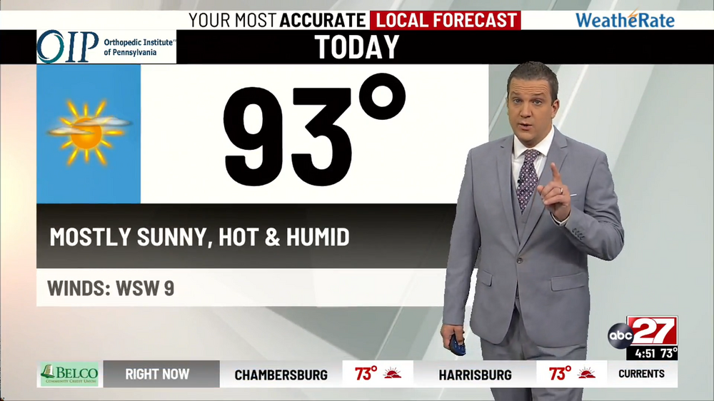
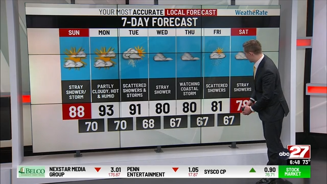
This looks like it's from you favorite TV Station!
-
Central Pa. Summer 2024
mahantango#1 replied to mahantango#1's topic in Upstate New York/Pennsylvania
That was in their post, I thought that was unusual. -
Central Pa. Summer 2024
mahantango#1 replied to mahantango#1's topic in Upstate New York/Pennsylvania
Pulled the pump this morning at the creek after I seen it came up 2 feet since yesterday. So the ground has a good bit of moisture in it in my garden. After it rained .36 yesterday the water was sitting on top of the ground in some spots of the garden for at least 4 hours. I hope I'm done irrigating the garden this year. -
Central Pa. Summer 2024
mahantango#1 replied to mahantango#1's topic in Upstate New York/Pennsylvania
I had over 5" rain in July so I think I'm good. -
Central Pa. Summer 2024
mahantango#1 replied to mahantango#1's topic in Upstate New York/Pennsylvania
.01 rain today. -
Central Pa. Summer 2024
mahantango#1 replied to mahantango#1's topic in Upstate New York/Pennsylvania
National Weather Service State College PA 1214 PM EDT Sat Aug 3 2024 PAZ006-010>012-017>019-024>028-035>037-041-042-045-046-049>053- 056>059-063>066-040200- /O.NEW.KCTP.FA.A.0005.240803T1614Z-240804T0200Z/ /00000.0.ER.000000T0000Z.000000T0000Z.000000T0000Z.OO/ Potter-Elk-Cameron-Northern Clinton-Clearfield-Northern Centre- Southern Centre-Cambria-Blair-Huntingdon-Mifflin-Juniata-Fulton- Franklin-Tioga-Northern Lycoming-Sullivan-Southern Clinton- Southern Lycoming-Union-Snyder-Montour-Northumberland-Columbia- Perry-Dauphin-Schuylkill-Lebanon-Cumberland-Adams-York-Lancaster- Including the cities of Lewistown, St. Marys, DuBois, Clearfield, Newport, Mansfield, Wellsboro, Bloomsburg, Berwick, Renovo, Trout Run, Williamsport, Sunbury, Altoona, Philipsburg, Mifflintown, Carlisle, Lewisburg, State College, Emporium, Lebanon, Chambersburg, McConnellsburg, Lancaster, York, Huntingdon, Johnstown, Selinsgrove, Pottsville, Ridgway, Coudersport, Laporte, Harrisburg, Mount Union, Hershey, Shamokin, Gettysburg, Danville, and Lock Haven 1214 PM EDT Sat Aug 3 2024 ...FLOOD WATCH IN EFFECT UNTIL 10 PM EDT THIS EVENING... * WHAT...Flash flooding caused by excessive rainfall is possible. * WHERE...A portion of central Pennsylvania, including the following areas, Adams, Blair, Cambria, Cameron, Clearfield, Columbia, Cumberland, Dauphin, Elk, Franklin, Fulton, Huntingdon, Juniata, Lancaster, Lebanon, Mifflin, Montour, Northern Centre, Northern Clinton, Northern Lycoming, Northumberland, Perry, Potter, Schuylkill, Snyder, Southern Centre, Southern Clinton, Southern Lycoming, Sullivan, Tioga, Union and York. * WHEN...Until 10 PM EDT this evening. * IMPACTS...Excessive runoff may result in flooding of rivers, creeks, streams, and other low-lying and flood-prone locations. * ADDITIONAL DETAILS... - National Weather Service Meteorologists are forecasting heavy rainfall over the burn scar, which may lead to flash flooding and debris flows. - http://www.weather.gov/safety/flood PRECAUTIONARY/PREPAREDNESS ACTIONS... You should monitor later forecasts and be prepared to take action should Flash Flood Warnings be issued. && -
Central Pa. Summer 2024
mahantango#1 replied to mahantango#1's topic in Upstate New York/Pennsylvania
Yes a tropical storm, slow moving would do a lot of damage. -
Central Pa. Summer 2024
mahantango#1 replied to mahantango#1's topic in Upstate New York/Pennsylvania
-
Central Pa. Summer 2024
mahantango#1 replied to mahantango#1's topic in Upstate New York/Pennsylvania
Anytime a tropical system is involved there is potential. Seen it too many times. And if the models are showing it a week out imo it will happen. -
Central Pa. Summer 2024
mahantango#1 replied to mahantango#1's topic in Upstate New York/Pennsylvania
So, you implying some of Pa. could go from drought to flood within less than a week? -
Central Pa. Summer 2024
mahantango#1 replied to mahantango#1's topic in Upstate New York/Pennsylvania
Hazardous Weather Outlook National Weather Service State College PA 448 AM EDT Sat Aug 3 2024 PAZ036-051>053-056>059-063-064-040900- Franklin-Montour-Northumberland-Columbia-Perry-Dauphin-Schuylkill- Lebanon-Cumberland-Adams- 448 AM EDT Sat Aug 3 2024 This Hazardous Weather Outlook is for central Pennsylvania. .DAY ONE...Today and tonight. There is an elevated risk of excessive rainfall later this afternoon into the evening that could result in isolated flooding particularly in urban areas. A couple of strong to severe thunderstorms capable of localized damaging wind gusts are also possible this afternoon and evening. -
Central Pa. Summer 2024
mahantango#1 replied to mahantango#1's topic in Upstate New York/Pennsylvania
I got up this morning and usually hear the creek if it's low. But this morning I didn't hear the creek. So I looked down at the creek and seen that it has risen quite a bit since last evening (2ft) Wonder if we'll get heavy rain today to raise the creek even more? I only got .36 yesterday so it must have rained quite a bit more somewhere else to raise the creek. Nws says theres an elevated risk of excessive rainfall today.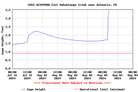
-
Central Pa. Summer 2024
mahantango#1 replied to mahantango#1's topic in Upstate New York/Pennsylvania
Don't flood Pillow out, you'll pay downstream.


