

mahantango#1
-
Posts
5,079 -
Joined
-
Last visited
Content Type
Profiles
Blogs
Forums
American Weather
Media Demo
Store
Gallery
Posts posted by mahantango#1
-
-
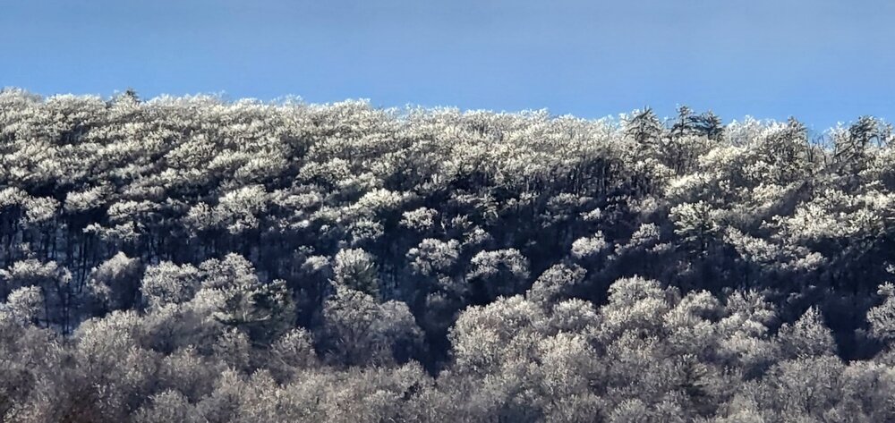
Top of the Mahantango mountain encased in ice
-
 3
3
-
-
2 hours ago, Bubbler86 said:
@Voyager @mahantango#1, yesterday was the first day of spring in China.
But not here ..yet
-
 1
1
-
-
Stating to freeze here temp 31 2.27 rain since yesterday.
-
The ice just broke loose on the Mahantango Creek have 1 66 rain so far.
-
1 hour ago, Blizzard of 93 said:
I think that Pillow is a more central location for our group to meet!
I have plenty of room here
-
1
-
-
1 hour ago, Voyager said:
You guys are supposed to go to ice before I do. I'm really worried about running tomorrow. Even if main roads are treated, side roads won't be, not to mention any ice weight on tree limbs.
Yes don't know what to expect tomorrow morning wind is still out of the south here.
-
Temp is falling 35 now after a high of 40
-
Rain so far .92
-
My high temp is supposed to be 40 today. A few days ago it was supposed to be 46. So a definite downward trend in temps. Currently 34. I wonder if we will be headed to ice sooner then the NWS says we will.
-
27 minutes ago, Voyager said:
I see State College is late to the warning and advisory party again...
Typical for them. I wonder if their office has the least warnings and advisory issued.
-
7 minutes ago, MillvilleWx said:
GFS continues to hold firm on the cold push. The NAM Nest was still a pretty solid ice event for areas north of a line of GAI-Savage-Annapolis. A more significant ice event is increasingly likely over areas north of I-70, especially once you get towards Central Frederick/Carroll/Baltimore/Harford counties. Temps will be borderline south of I-70 for areas below 500’. Above 500’ 27-30° will be possible with light/mod precip still in the area. CAA will still be occurring through the AM, so that benefits the icing setup with the FRAM numbers getting more substantial through the AM as a result. I think WSW criteria ice is possible for the northern tier, but a forecast around 0.1-0.2” is probably a good start. Glaze to 0.1 is probably solid starting point south of there.
Regardless, local impacts to travel will be likely. Roads will get icy through the day and remain that way thru Saturday AM. It’s not going to be an all timer at first glance, but still not half bad. DC area will likely miss a majority of the ice.
What are your thoughts above the Mason Dixon line or should I say north of Harrisburg,pa?
-
Thoughts from DT: The operational GFS model for the past few days has been trying to drive the cold front rapidly through New England, into the northern half of the Mid-Atlantic region on Thursday, and into New Jersey, Pennsylvania, Maryland, northern Virginia, West Virginia, on Friday. The result would be rain changing to heavy snow and ice in much of Pennsylvania, New York State, and New England (which seems like a good probability). Undoubtedly, even coastal New England is going to see significant ice as well as New York City, New Jersey and southeastern Pennsylvania Thursday night into Friday morning. And because the GFS model is so aggressive with the cold air it actually allows the rain change to sleet and freezing rain in most of Maryland. the Eastern portions of West Virginia and the northern half of Virginia during the day on Friday February 4.
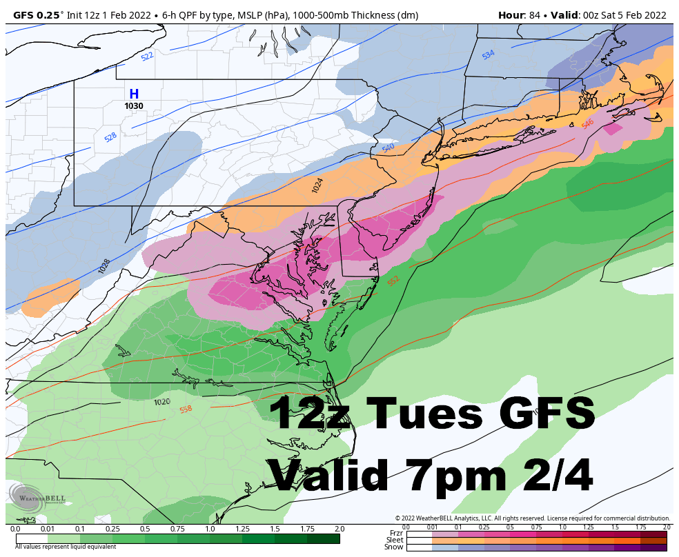
If that were to happen then they would be a tremendous ice storm in Southern New England most of Pennsylvania, northern New Jersey, NYC, and Southeast New York. the ice would change to snow and there would be significant ice buildup and snow accumulations on top of the ice in the northern half of New England most of New York State and Northwest Pennsylvania would see all snow. Indeed, this is exactly what the operational GFS model has been showing for the past few days.
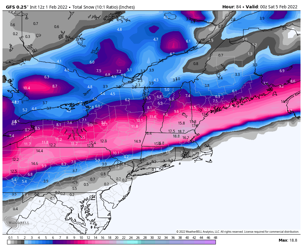
But there is a problem with this particular kind of scenario. It has to do with the development of waves of LOW pressure tracking along the front in a SW to NE direction — from Arkansas to Tennessee to Virginia to the Delmarva on Thursday and Friday. As a general rule, when LOW pressure tracking along of front in SW to NE direction, it is hard to get the cold air that is located Northeast of the surface LOW pressure to advance the Southward. You have to wait until the LOW pressure area is clear as the region. Only then will the cold front sweeps in, temperatures will drop and the precipitation comes to an end
-
Went to Sunbury, pa. Today. While in Sunbury by the river around 11 this morning the temp on my car was 22 I got out of Sunbury about a mile and a half on top of a hill on rt 147 the temp went to 28. It amazement me the temp difference location to location. And I know that ground must be really cold that's its limiting the melting during the day.
-
Hit 40 today now that sun went down 28. Seems very little melting with that ice pack we have.
-
2 hours ago, MAG5035 said:
I want to see the map with all the start times for all the different p-type transitions.
I didn't see any yet from him. But your right those start times are critical!

-
1 minute ago, Bubbler86 said:
Snow moved from Northern MSV to Northern LSV. 1-2" type as the precip is leaving so.....
So will there be freezing rain from this. Or just rain an maybe a coating of snow
-
DT says the gfs is wrong. He Says with the 2nd low moving sw to ne the south winds won't let the artic front push south
-
17 minutes ago, sauss06 said:
Why does this upcoming event remind me of the V-day storm of 2007 ?
Is that when I-78 was shutdown?
-
Watching the weather on tv and read NWS forecast lows for last night said it wouldn't nearly as cold last night as Sunday night. It is 6 right now and yesterday morn it was 4 so 2 degrees is not nearly as cold.
-
1 minute ago, pasnownut said:
Go pull the snow map up for this weekend as well as beyond.
Dont have coffee in your mouth. You'll be cleaning up your screen. Fun to look at.
well MAYBE just Maybe this one will score the coup. It has to be right sometime. Even a broken clock is right 2x a day.
-
4 this morning.
-
My click an point forecast keep dropping Temps Wednesday thru Friday. And it says rain Thursday night with a low of 28.
-
3 minutes ago, Voyager said:
Me too. It's just too cold. I don't mind seasonal cold, but when I have to wear a half load of laundry (layers) to work, it's just too much.
I guess we will stir-up a hornets nest within the forum on wanting warmer weather. I'm with you on seasonable cold but not this 10-20 below normal stuff. I like some snow too but these minor events and frigid conditions that seem to last a long time, not so much.
-
1
-
-
2 this morning. I guess we'll see what the late week storm system has in store for us.
Central PA - Winter 2021/2022
in Upstate New York/Pennsylvania
Posted
Letting go of a passion, any passion is that we pursued all our lives and seen circumstances beyond our control to make it unenjoyable is hard.