

mahantango#1
-
Posts
5,427 -
Joined
-
Last visited
Content Type
Profiles
Blogs
Forums
American Weather
Media Demo
Store
Gallery
Everything posted by mahantango#1
-

Central PA Spring 2023
mahantango#1 replied to Itstrainingtime's topic in Upstate New York/Pennsylvania
Looks like it's basically over here. 1.24 rain today. -
Central PA Spring 2023
mahantango#1 replied to Itstrainingtime's topic in Upstate New York/Pennsylvania
The bulbs did great that were in there for 4 years. Then they were so close together they need divided. Thus they were fighting with each other. I wanted to dig the bed up after 3 years but didn't have the time. -
Central PA Spring 2023
mahantango#1 replied to Itstrainingtime's topic in Upstate New York/Pennsylvania
Just passed 1 inch of rain since 2:30pm -
Central PA Spring 2023
mahantango#1 replied to Itstrainingtime's topic in Upstate New York/Pennsylvania
That's great news. Glad to see at least one resident of the burg donating housing materials. Is WM set up also to confiscate wind blown garbage cans? -
Central PA Spring 2023
mahantango#1 replied to Itstrainingtime's topic in Upstate New York/Pennsylvania
Be on the lookout for flying shingles in Marysville, originating from the burg. -
Central PA Spring 2023
mahantango#1 replied to Itstrainingtime's topic in Upstate New York/Pennsylvania
Nws fairly optimistic for today: Today A slight chance of showers and thunderstorms, then showers and possibly a thunderstorm after 3pm. Some of the storms could produce heavy rainfall. High near 72. South wind 11 to 17 mph, with gusts as high as 30 mph. Chance of precipitation is 80%. New rainfall amounts between a half and three quarters of an inch possible. Tonight Showers, mainly before 8pm. The rain could be heavy at times. Low around 44. West wind 3 to 6 mph. Chance of precipitation is 80%. New precipitation amounts between a quarter and half of an inch possible. We don't need frost and freezing temps next week. -
Central PA Spring 2023
mahantango#1 replied to Itstrainingtime's topic in Upstate New York/Pennsylvania
Hopefully we all get some rain today. -
Central PA Spring 2023
mahantango#1 replied to Itstrainingtime's topic in Upstate New York/Pennsylvania
Dt is gung ho for tomorrow: *** ALERT STRONG/ SEVERE STORM SATURDAY AFTERNOON EVENING IN CENTRAL/ EASTERN NC VA MD DEL SOUTHEAST PA SOUTHERN NJ *** The cold front and it's accompanying showers and storms will advance from west to east. IMAGE #1 shows the leading edge of the front in West Virginia / southwest Virginia and western North Carolina around 7-8 am on Saturday morning. As the front progresses eastward into the warmer air and the Sunshine … the showers and weak storms will become more significant and intensify. the short range high resolution models are showing that as the cold front approaches Interstate 95 they will really begin to become serious during the late afternoon and evening hours. By 4:00 pm. SEE 2ND IMAGE ! there will be a line of moderate and strong thunderstorms running essentially north to south from central Pennsylvania into central Maryland -near Hagerstown and Frederick but to the west of Washington DC --then into north central Virginia just to the west of Interstate 95… West of Fredericksburg -west of Richmond and west Emporia and into Central North Carolina near Greensboro. By 8:00 p.m. this line is really exploding - the line has cleared Richmond and is moving into Southeast Virginia. It has passed to the east of Raleigh-Durham and it is also cleared Washington DC / Baltimore. The strong / severe line is approaching Philadelphia and moving into the west and half of the Delmarva and is hitting the Northern Neck and Middle Peninsula into the Chesapeake Bay. EXPECT TO SEE SEVERE THUNDERSTORM WATCHES issued Saturday midday for all of Central and Eastern Maryland …southeast Pennsylvania …the Delmarva …Southern New Jersey …Central and Eastern Virginia ….Central and Eastern North Carolina and this includes of course Hampton Roads and the Chesapeake Bay Region for marine interests. At this time I don't think a tornado watch will be required but that cannot be ruled out. Finally behind this system much colder air moves Which is something I have been talking about on the video on Wednesday and in the three week newsletter for the past two weeks.. A significant Frost is a good bet for the Virginia Piedmont ….the Shenandoah Valley ….West and Central Maryland ….the Eastern portions of West Virginia ….Southwest Virginia…. and Northwest North Carolina mainly on Monday and Tuesday Mornings Before Dawn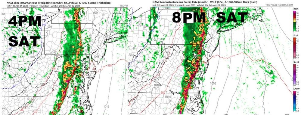
-
Central PA Spring 2023
mahantango#1 replied to Itstrainingtime's topic in Upstate New York/Pennsylvania
Damn, maybe blizz will show the snow maps later tonight for next winter. -
Central PA Spring 2023
mahantango#1 replied to Itstrainingtime's topic in Upstate New York/Pennsylvania
I don't think they had the proper cooling after I planted them about 90% of them bloomed. Some on the small side. Dug up the tulip bulbs that were in there for about 5 years and purchased new ones from a place in Michigan. But it was mid November when I did all this. So with the winter we had that was on the warm side, I think they didn't receive the proper chilling they require which is about 15 weeks. I'm sure they will look better next spring. -
Central PA Spring 2023
mahantango#1 replied to Itstrainingtime's topic in Upstate New York/Pennsylvania
You feel like we're going into a wetter, rainier period now? The rain is welcome but not the below normal temperatures. -
Central PA Spring 2023
mahantango#1 replied to Itstrainingtime's topic in Upstate New York/Pennsylvania
DT's look on the weather is bleak for the next 3 weeks starting next week. Cool and wet and the threat of several nights of frost and freezing temps. www.youtube.com/watch?v=mFK0NOXIDVI -
Central PA Spring 2023
mahantango#1 replied to Itstrainingtime's topic in Upstate New York/Pennsylvania
Are you the modern Albert Hammond? -
Central PA Spring 2023
mahantango#1 replied to Itstrainingtime's topic in Upstate New York/Pennsylvania
Nearly tear-shaped, Hoover’s Island is a 275-acre piece of land sitting in the Susquehanna River between Fishers Ferry and Herndon. Farmers still grow corn on the island as well as on neighboring Little Hoover’s Island just to the north, but no year-round residents live there anymore.Dale Reiner and Ken Hoover of Dalmatia will use historical photos and slides to illustrate their talk about long-ago life on the islands. Once there were three farm families who were permanent residents, and summer residents occupied nearly a score of cottages.There was also a school attended by children in the Hoover family. Flat boats and canoes provided transportation between the islands and the mainland, although during periods of low water, farmers sometimes drove their tractors and trucks across the river bed.The Pennsylvania Game Commission purchased both islands during the 1960s.Mr. Reiner is president of the Mahanoy and Mahantongo Historical and Preservation Society. -
Central PA Spring 2023
mahantango#1 replied to Itstrainingtime's topic in Upstate New York/Pennsylvania
Yes they all are, but being an island on the river there is more moisture available then up on the hills. -
Central PA Spring 2023
mahantango#1 replied to Itstrainingtime's topic in Upstate New York/Pennsylvania
Was talking to the farmer that farms our land yesterday. He said they heard that a farmer already planted field corn on the big island on the Susquehanna River at Herndon. That is a big island. -
Central PA Spring 2023
mahantango#1 replied to Itstrainingtime's topic in Upstate New York/Pennsylvania
A frosty 30 this morning. And our strawberries are in bloom. I don't know if that destroy the blooms or not. Dt's forecast is not very optimistic. -
Central PA Spring 2023
mahantango#1 replied to Itstrainingtime's topic in Upstate New York/Pennsylvania
Yes I remember track practice and the track meets with this kind of weather. I remember freezing during the practice sessions in jr.high and high school at Milton Hershey. That cold wind was nasty in the open down there. -
Central PA Spring 2023
mahantango#1 replied to Itstrainingtime's topic in Upstate New York/Pennsylvania
I just don't know what season to dress for when you want to go work outside. -
Central PA Spring 2023
mahantango#1 replied to Itstrainingtime's topic in Upstate New York/Pennsylvania
It might be possible. -
Central PA Spring 2023
mahantango#1 replied to Itstrainingtime's topic in Upstate New York/Pennsylvania
We'd have get an independent study from DT on that. -
Central PA Spring 2023
mahantango#1 replied to Itstrainingtime's topic in Upstate New York/Pennsylvania
That would be great to see the missing sections built again. -
Central PA Spring 2023
mahantango#1 replied to Itstrainingtime's topic in Upstate New York/Pennsylvania
50 this morning here. JB was saying that some kind of freak event could happen next week. -
Central PA Spring 2023
mahantango#1 replied to Itstrainingtime's topic in Upstate New York/Pennsylvania
The dryness continues .10 rain over night. Monthly total now .59 -
Central PA Spring 2023
mahantango#1 replied to Itstrainingtime's topic in Upstate New York/Pennsylvania
Would be nice to see a lightning show and get some rain.


