

Met1985
-
Posts
15,473 -
Joined
-
Last visited
Content Type
Profiles
Blogs
Forums
American Weather
Media Demo
Store
Gallery
Posts posted by Met1985
-
-
Merry Christmas you filthy animals!
-
 5
5
-
-
4 minutes ago, ILMRoss said:
Good grief has everyone collectively memory-holed December 2015 which to this day is the craziest month-long torch I've ever seen? This month hasn't been ideal but Christmas Eve 2015 there was a dew point of 72 in Wilmington.
Yeah I remember it was 70 Christmas day here in the mountains. Short sleeves and grilling weather for sure. We actually had some back to back very warm Christmases.
-
Just now, RT1980 said:
Yeah, this current winter is seeming to shape up like last wit BA Nov and AA Dec. The SER has been strong for what seems like a decade. I’m not saying it’s gonna flip and we’ll get record snows, I’m just saying it’s still too early to write it off as some have.
Im not writing off winter either but there are a lot of negatives and not a lot of positives currently but that doesn't mean we cannot score but the PAC NW is going to have to calm down.
-
3 minutes ago, John1122 said:
We've had two really warm overall days. I've still managed 25 or below for the low 11 days this month with one more day at 29. Had two days with 50 for the low and another with 48. Two days of +18 and one +16. Overall +5 for the month. December 1984 was +9. It's maybe the warmest December of my lifetime here that I recall.
LOL that's before my time. We on this east side of the mountains we have set several record highs by several degrees. This seasons PNA is at record negative territory on the west coast and it would take a mighty block up top to beat back the SER. yall can do better than us though because when the cold dumps into the west and we have a strong SER the mountains help keep the cold away. We will see but I don't see the light at the end of the tunnel currently and yes that's being pessimistic.
-
1
-
-
The thing that gets me is how warm this airmass we have had is. I know in and around this area we have shattered several record highs and record low highs as well. This is not a normal pattern.
-
1 hour ago, RT1980 said:
They have been showing change, albeit, it keeps getting delayed. I know it’s not the best setup synoptically and the past few years haven’t been kind but isn’t today the first day of winter?
Well the issue is feedback on the MJO, the PNA is at record negatives this year so that means that virtually for us the SER is in control until the PNA settles down. The NAO and AO will be not help unless the SER gives in which currently doesn't look that way. We may have a slight window but we are shattering recod highs and record low highs left and right. This December has been way above normal for the SE. I mean we are breaking record by like 5 or 6 degrees. That is extremely impressive and very telling.
-
1
-
-
23 minutes ago, RT1980 said:
Everyone so down off of a model run?
It's been weeks of model runs really.
-
5
-
 1
1
-
-
Some sleet and snow here.
-
3
-
-
Nothing here to the West. Cold but dry.
-
The euro was beautiful..... for the West lol.
-
2
-
-
6 minutes ago, eyewall said:
Hopefully next winter will work out.
Yep because there is nothing on the horizon.
-
1
-
-
1 minute ago, Carvers Gap said:
John had a good post earlier about phase 7.
For what it turns into in January? Yeah I saw that. Hoping things pan out for at least a chance or two of snow during this pattern break.
-
This so called pattern change is becoming delayed again and again.
-
1
-
-
My thing is the MJO is just not going to move for us. Seems like we are back peddling again with it being stuck in phase 7. I know feedback issues and such but like last year it looks like cold dumps out west then may bleed east. We will see.
-
2
-
-
20 minutes ago, Carvers Gap said:
Boy, we had better hope the 6z and now 12z GEFS are not right. 12z GFS never went BN for the entire run. 12z GDPS looks great. I don't think the American suite is handling the block well. Crazy how the model sees it first, and then tries to break it down so quickly. Once the block retrogrades into the Davis Straits and the model gets inside of d12....should see some more cooling in the model. Though admittedly, this feels almost exactly like last winter without the Christmas cold snap. But as Cosgrove mentions, at some point this pattern could send brutally cold air southward.
Yeah im really trying to be patient but we have been burnt so many times im like well it is what it is. There are signs there but this season feels so off already. Really weird pattern we have been stuck in.
-
1
-
-
16 minutes ago, ILMRoss said:
December has always been our 'dud' month. You can certainly have events but I wouldn't weigh losing this month as heavily as losing Jan or Feb.
(and that's not just anecdotal- Eric Webb put together a really nice graphic a few weeks ago showing this)
Yeah I can remember growing up and always remembering winter really starting around Christmas or New Years.
-
1
-
-
14 minutes ago, Carvers Gap said:
Models looks really good at 12z. GEPS ensemble looks perfect. -NAO is showing up. Models are sensing that feature now. Always seems like it takes a few days to reflect effects at the mid latitudes once the NAO shows up on modeling.
The models seem to always have trouble with blocking...
-
1
-
-
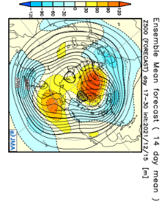
48 minutes ago, griteater said:
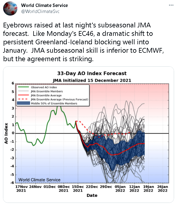
JMA Weeks 3-4
Grit great to see you posting. We have missed you.
-
1
-
 1
1
-
-
19 minutes ago, Mr. Kevin said:
I have a question. Do you think if we get that Greenland block that's more central to west based and mjo propagation, will we get into a colder regime east of the rockies?
Im not Grit but if the Pacific doesn't ease up then there is going to be a tug of war with were the cold goes because the PNA is a formable beast currently.
-
2
-
-
5 hours ago, Buckethead said:
It's a balmy 51° at 4400 in Wolf currently and 25° down at 2800 in Burnsville. I'm embracing the inversion and sleeping with the windows open lol.
Sent from my SM-G970U using Tapatalk
Left the house at 4:30 and it was down to 21 degrees. Beautiful night.
-
2
-
-
1 minute ago, Carvers Gap said:
I have no idea what that last sentence means.
I think he was talking about the severe cold snap in the mid section of the country. But I can remember when we would get at least a few night of below zero readings every winter.
-
39 minutes ago, Mr. Kevin said:
Until the euro gets on board, its skeptical for me to believe. I like all the models to indicate something like that but I understand its exciting to see
Eh the Euro is not what it used to be. It's better to have consistency across the board than just one model.
-
1
-
-
1 hour ago, Maggie Ace said:
We will need to be aware for possible wind damage from the line of storms moving in. Seeing indications of higher winds aloft mixing down to the surface in E TN.

Yep that front is fixing to blow through big time.
-
At this point I like New England for winter weather. The PNA is a solid pain in the butt. I know there are grumblings of possible changes in the pattern but I do not see it in the next two weeks.

Mid to Long Range Discussion ~ 2022
in Southeastern States
Posted
You cannot tell me this hasn't been an extremely warm pattern for December. Asheville shattered the record for Christmas day. People trying to live in a pipe dream this season....