

Nelson
-
Posts
541 -
Joined
-
Last visited
Content Type
Profiles
Blogs
Forums
American Weather
Media Demo
Store
Gallery
Posts posted by Nelson
-
-
Looks like we will finish with 3.8" here. Little lower than my prediction but sounds like some higher amount nearby. Overall, the forecasts did pretty well around here.
-
Eyeballing 2" here. Winds still gusting and decent rates.
-
Freezing rain for a good two hours to start. Looks like we are finally switching to snow... Also, stronger winds than I was expecting. Blowing pretty hard out of the SE
-
Models have been pretty consistent with averaging around .5 qpf in SW Dane County. I'm going with a 5-6" call imby. Remarkable overall consistency for days now (outside of the usual wobbles) as opposed to the last system where we were still seeing some decent shifts leading into the event - so I don't know if we'll get that last minute shift north this time. I think the heaviest totals look to stay just south of the WI/IL border. Good luck everyone.
-
 4
4
-
-
6.9" final here in western Dane county. More than I thought when I first looked out the window. Couple of 10" drifts. Nice overachiever.
-
3
-
-
1 minute ago, McHenrySnow said:
Am I writing in a foreign language? Or do you guys not bother to read. Where did I say I’m choosing one model over the other. I’ve repeatedly said my expectations have increased and I’m not worried about getting completely shafted like I once was.
At the end of the day, if you have a met tag there are high expectations for the content you post. Most of us expect to see folks with met tags posting analysis and helping the rest of us understand better. I've seen neither from you. Mostly what I see is complaining. So if you're going to carry that met tag, and continue to complain and otherwise not provide any meaningful analysis, you should expect to get trolled. It really is as simple as that.
-
1
-
 5
5
-
-
1 hour ago, Hoosier said:
Are you saying you like this view better?
YES
-
Very small flakes here but snowing at a decent clip. Up to about an inch so far. I'll stick with my initial thought of 6-7" for mby but I'm starting to think that may be on the high side. Good luck to the border areas where the highest totals look to be.
-
3 hours ago, weatherbo said:
Karma has come knocking.
The COVID thread must go!
Delete the COVID thread and it will snow.
Just as a general idea I completely agree with this comment. Nobody needs that kind of negativity in their lives. Appease the snow gods.
-
 2
2
-
 4
4
-
-
Freakin' summer time low
-
2.7" (.27 liquid) yesterday and overnight. 3 day total at 6.6"
-
2
-
-
Switched over to drizzle now. 35.6F and rising very slowly
-
2.3" (on .19 of liquid) yesterday and overnight
-
1.6" overnight here (.15" liquid).
-
MKX
LONG TERM...

Thursday Night through Saturday...Forecast Confidence is Medium.

Models have started to trend toward a stronger deepening low that
lifts NE Friday into Saturday. Previous guidance was flatter with
the progression and kept some of the precip bottled up further
south. This change would favor more precip wrapping into
southeastern Wisconsin as the low pushes east. Now with that
said, there are still some questions as to whether models have a
good handle on the system. The initial low digs into MO/AR
Thursday night into Friday and transitions into a closed low over
the TN/OH Valleys. Then a second piece of energy digs south and
this is what could cause the system to deepen as the two features
phase over the OH Valley. The past few systems that have impacted
the area have had a similar trend where 2-4 days (where we are
currently) out models had more significant phasing and stronger
lows which bumped up QPF totals. Then as you got closer in the 1-2
day period they backed off and QPF amounts trended back down.
This has largely been the result of models inability to handle the
phasing of closed lows. Will be keeping a close on eye on how
guidance handles these features over the next few model cycles.
Subtle adjustments to QPF were made with this forecast and these
changes keep us below the 50th percentile for both QPF and Snow
amounts. This is likely a good place to be based on the lingering
uncertainty. Both GFS and ECMWF ensemble guidance are narrowing in
on some of those higher QPF and snow amounts. So, if models hold
onto this trend will likely continue to nudge amounts upwards.

Another complicating factor is that with the low deepening warmer
air gets wrapped in and temps Friday through Saturday could be
such that we end up with more of a mix of rain/snow than all snow.
The profile aloft is cold enough for all snow but there could be a
deep enough layer near the surface to melt some of the snow. Do
think models could have a slight warm bias to temps and have
nudged values down slightly but this would still support a
rain/snow mix.

The system exits to the east Friday night into Saturday with light
snow ending by Saturday afternoon. Temperatures through the period
hold pretty steady around freezing for lows and into the mid 30s
for highs.
-
Moderate snow has commenced.
-
1
-
-
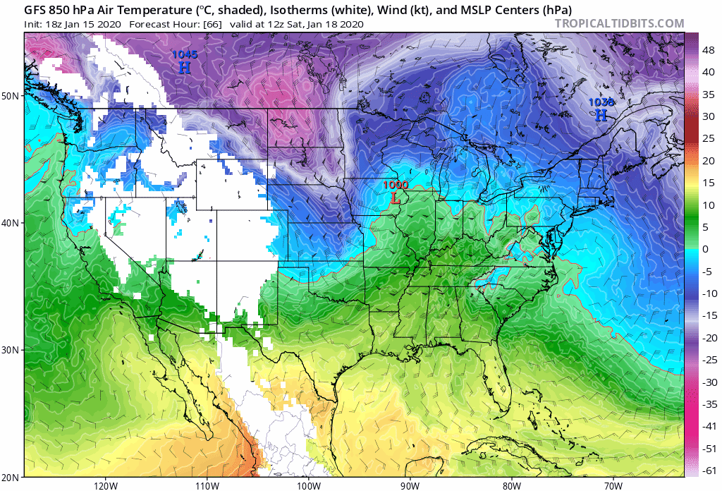
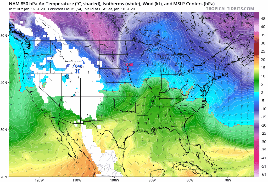
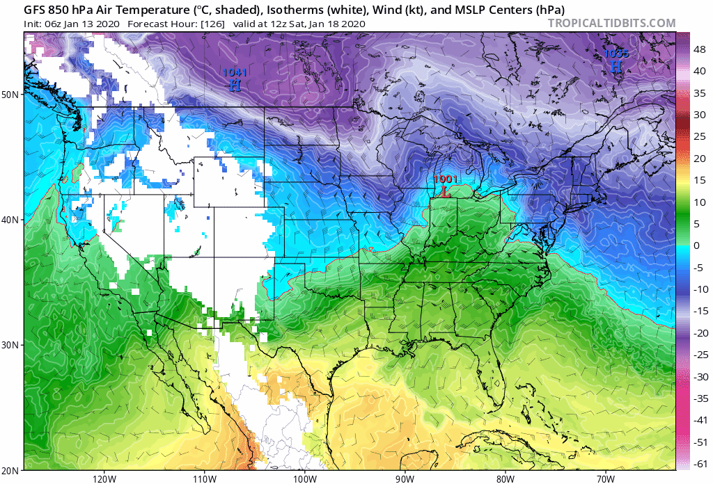
Northern extent of the 850 temps have trended south, over the past 24 hours, on the GFS. NAM 850s have started trending north. Feels like the WI/IL border will be a good compromise for northern extent of the 850s. 950 temps are slightly warmer. What that means for precip types, who knows.
-
2
-
-
Weather channel trolling Alek.

-
2
-
-
12z GFS trended a little bit south with SLP but 850 temps crept north a bit (slightly stronger?).
-
1
-
-
7 hours ago, A-L-E-K said:
Ride whatever shows a rainer
It's going to rain in CHI for the rest of the winter. You should just make calls for Madison from here on out
-
2
-
-
20 minutes ago, Thundersnow12 said:
Waited days to post this
Brutal.
")
-
30 minutes ago, ChiTownStorm11 said:
It's undeniable that the GFS won this storm. It has been showing the southern solution for days.
It sure seems like the early GFS ideas of a more SE/weaker track is going to win out. It would appear that my "Euro is king" call, along with the NW trend, was premature. Overall, models were pretty disappointing for this storm.
Feel bad for the NWS offices that will take the brunt of the criticism from the less meteorologically educated public.
-
1
-
-
Moderate snow now. Pushing 2 inches. Radar looking decent but cutoff isn't too far away. Model trends are not good this evening for round 2 IMBY.
-
I was out and about, a little bit ago, and it was solid rain and 27F (truck thermo) about 3 miles south of my house.
-
1
-
1
-


Feb 3rd - 5th Potential strong stm threat
in Lakes/Ohio Valley
Posted
Somewhat of an odd storm evolution - if you simply looked at the SLP track, it looks like a classic mid-west snowstorm but surface features don't really play out that way (looks more like a glorified frontal passage). Much like the last storm, models have been fairly consistent with roughly .5 qpf for mby. I think 3-5" looks like a good call.