RogueWaves
-
Posts
2,559 -
Joined
-
Last visited
Content Type
Profiles
Blogs
Forums
American Weather
Media Demo
Store
Gallery
Everything posted by RogueWaves
-
About 24 hrs ago I wrote this off saying it wouldn't come full-circle for DTW. Might have words to eat if this keeps up.
-
Wrote this off as a rainer yesterday for DTW. WPC keeping us in the heavy "something" zone.
-
maybe
-
As we've seen many times this winter. Primarily when the thermals are mega-borderline. Some have still managed to produce a very narrow snowstorm zone, while others have just been cyber snow and little more.
-
Either way. I'll ride the 34F and rain as a slight majority. Let's call it 50/30/20% for RN/ZR/IP outcome from here. And no, we won't need skates since our ground is anything but frozen. The ISW wasn't about slippery roads at all, nor can this be if ZR actually plays out. WPC does not see a snowstorm in our future
-
This is 1/25 on 'roids...and going NW of us. Gonna b 34 Rainer for DTW again. Yay. But, we need the hydro
-
I'd rather push the ignore button until it's inevitable. That's what I did with the S trending ice storm. It is a lot more fun "tracking" when you know it's real and not going poof like the Christmas Big Dog. I'm not into the pessimism posts. Gave that up after the Jan 25th storm held.
-
Man, we sure are hungry for model abuse in here.
-
It missed "snowless" already, but now it's just another well BN month, like fractionally so.
-
I thought that's what you're doing out there every day, lol
-
There's your "more winter". Getting our late March inchers a month early. Tbh, the ice storm was my final interest of the season. Moving on from the cold season so when I opened the door to all white this morning not only was it a small surprise but a bit of a let-down lol, even tho it's mostly gone. Looking for sun and decent conditions going into March. Prolly go the other way and get a "reverse spring" as has been the norm in this Tri-Nina.
-
Not a fan of ice, but this storm actually elevates the winter grade in my book.
-
March 1976 was the epic all-timer with 2+ inches of ice centered along the M-46/Saginaw corridor. I skated down the street in my neighborhood. Presuming they are referring to that one not quite 50 years ago. It was bad as in Genesee Cnty, but not sure about Detroit Metro.
-
Glad it's not worse for you. When I saw GRR's graphic saying up to 3/4" ice and "as bad as 2013" I figured someone in that zone would be in trouble. A lot of trees in your area. So far, I have branches sagging, but haven't heard any breaking. I may just barely escape damage by the slimmest of margins.
-
Glad to hear. So far, so good here as well.
-
I keep imagining if we had legit cold air and this was a snowstorm. I so wanted to stay up there. Missed it by mere hours. APX getting raked
-
Thx. Missed my brown ground. Thought temps would slowly RISE. Apparently that was too optimistic. For DTW...The peak freezing rain intensity (moderate to brieflyheavy) will persist through 04Z before it moves off to the east. Sfctemps will hold around 32 degrees through the evening, then theywill actually drop a degree or two overnight.
-
So.. 000FXUS63 KDTX 222327AFDDTXArea Forecast DiscussionNational Weather Service Detroit/Pontiac MI627 PM EST Wed Feb 22 2023.UPDATE...Reports of a tenth to near a quarter inch across Lenawee and WayneCounties has prompted an upgrade to an ice storm warning forLenawee/Monroe/Wayne Counties. Locals near Lake Erie in Monroe Countywill likely have limited icing, however farther inland (particularlynear Petersburg, Dundee and Milan) icing to a quarter inch isexpected.The convective burst which rolled across the area earlier andproduced a few elevated thunderstorms proved very efficient at icingper spotter reports. Given upstream radar and with the loss ofdaytime heating, icing on trees and power lines should prove veryefficient through the rest of the evening.&&
-
Coming back into the Metro from the west. Ofc driving in traffic but N side of Ann Arbor may have been pushing 0.4-0.5 accretion. Nervously drove under a large tree that was leaning way over my lane. Looked primed to plunge at any moment. Drooping power lines and some shorter trees with branches touching the ground. Stopped for a couple groceries and power went out for about a minute. Got to see my first ICE STORM WARNING on the MDOT signs. That was cool. Just missing Snow Squall Warning for the complete set of winter headlines. As Hoosier says, some region will be "just right" for the maximum combined effects. Hopefully not too large an area here in SMI.
-
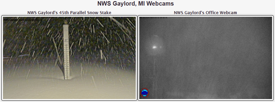
Widespread 3-6+ where I am in NMI. Classic winter morning. Car thermo at 23F. No melting. What's that?
-
DTX: With the current outgoing forecast out of the way will offer to insight in a potential deviation point as this gets into the latest model trends and ramifications we`re watching. Hi-res runs this past evening and tonight from the HRRR/RAP to NAM Nest (and to a lesser magnitude the NAM12) are having a harder time lifting the frontal slope into the area resulting into a shallower elevated warm nose over the I-69/M-59 corridors, increasing sleet probabilities. If this scenario pans outs, there would be a southward shift in primary freezing rain axis towards the I-96/94 corridors... which as a sidenote would be more in line with what the GFS and Canadian-NH have been advertising. In addition, this would limit the chances to switch to all rain over the far southern CWA instead remaining wintry mix/freezing rain and increasing icing... which could warrant a need for an upgrade of some or all of the advisory counties to an ice storm warning. Areas of additional concern/uncertainties are the effect of the still open waters of Lake Huron sitting firmly in the mid to upper 30s, degree of latent heat release from higher rainfall rates (or conversely any wet bulb cooling given dewpoints in the 20s), and the effect on ice accretion efficiency given the moderate precip rates. Unfortunately these three points remain fairly nebulous and really won`t be known until the event actually begins. So basically, they won't know until it is already a done deal. Perfect for that office. They can then bump headlines.
-
22/0z RGEM pounding Metro Detroit with snow tomorrow noon Then proceeds to destroy with ZR
-
I think they're right. The only good thing is temps are expected to get way above freezing Thursday. Doesn't stop the damage during the event, but it's better than just plunging into the deep freeze as so often happens.
-
APX snippet. Wish I could just phone work and stay up here, lol. If we do manage to get the stronger gusts as guidance suggests...in combination with the potential for intense snowfall Wednesday night...not out of the question visibilities could drop to 1/4 mi or less...which would put us pretty close to blizzard conditions at times overnight. Additional concern with the winds is that if we are able to get into the ice at all...suspect winds will be efficient at helping ice accumulate on surfaces.
-
Which one?