

real
-
Posts
944 -
Joined
-
Last visited
Content Type
Profiles
Blogs
Forums
American Weather
Media Demo
Store
Gallery
Posts posted by real
-
-
Huge flakes now falling downtown
-
3 minutes ago, nj2va said:
I’m thinking 8-10” for DC is likely. I’m at 6.2”. We’re in a great spot this afternoon/early evening.
Solid moderate snow now in Downtown DC. Places north of U Street should do well. But It may just be a degree too warm in center city for streets to start caving again but we’lll see. Last night, streets north of U Street caved about 3 hours before streets south of U Street did. By 5 am, though, even downtown streets needed to be plowed.
-
Nice snowy scene Downtown in D.C. Big flakes but not accumulating on any paved surfaces.
-
Radar looks good but just basically non accumulating heavy flurries currently in midtown DC. Not complaining, but hoping to step it up some tomorrow am..
-
2 minutes ago, NorthArlington101 said:
30 and snowing again. Too light to cave the wet streets for now.
I worry a bit the snow will never stay heavy enough long enough to overcome the UHI in immediate Metro. We’ll see, but that is only thing I can see that limits this potential. It is late January, but not like the Jan 30 2010 storm where it was in low 20s throughout the storm.
-
 1
1
-
-
What are temps supposed to be tomorrow? Tonight, it still seems a bit warm to maximize accumulations in center city DC.
-
After the dry slot that appears to be heading for the DMV, what time is the snow supposed to start back up again tonight?
-
Nice snow in Downtown DC. Unsalted pavement and parkings lots are starting to cave.
-
Steady light snow in Downtown DC, but not stciking yet to any paved surfaces. A light coating on some cars that have been parked for awhile.
-
Very light flurries just started in Downtown DC
-
Just now, LeesburgWx said:
Dude, I am joking. Come on
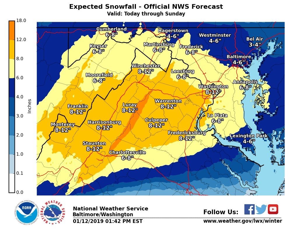
But weird though the maps on LWX site still show DC with 6 to 8. But LWX just tweeted the map I posted
-
Just now, LeesburgWx said:
Fake News. I see yellow over DC. Not Orange
It clearly says 8 to 12 under Washington.
-
1
-
-
NWS ups DC to 8 to 12

-
7
-
-
I voted for Feb. 5 2010, but it was a tough decision between that and Feb. 2003. I wasn't around for Jan 1996, so ignored that.
In Feb 2003, I was living in Baltimore and remember how it came as sort of a surprise. The evening news on that Friday was predicting like 8 to 12 inches -- a sizable storm, but nothing to panic over. And then on that Saturday, it sort of seemed like the storm could be a bust. What little fell that morning was quickly cleaned off the streets. And i recall hearing news reports that night that the snow had hit northern Virginia. So I went to bed, but woke up that Sunday morning, like 5 a.m., and there was already like 3 inches on the ground in downtown Baltimore. And then thunder snow -- very loud . And as the day progressed, it just dumped snow for hours. By evening, the drifts in city streets were waist high. But then about 10 p.m., it turned to sleet. That changeover was the only thing that kept accumulations in the city closer to 2 feet instead of 3 feet or more. By Monday morning, however, there was another quick burst of heavy snow that added an inch or two o totals.
And the streets in Baltimore were a mess for days.The snow and sleet compacted into thick hardened mounds that were nearly impossible to clear off. And the mayor at the time, maybe O'Malley??, had to request the National Guard. That was the only time I remember seeing National Guard Humvees deployed for a real emergency.
Still, its hard to separate Feb. 5 2010 from what happened 4 days later, so I voted for that. Plus, the build-up and model-watching for that storm gave you the true experience of preparing for a major storm.
-
Still surprised that surprisingly large and north dry slot stopped just about there due to the pivot. Pretty sure it was never modeled to be anywhere close to NOVA, but goes to show you large storms can have large dry slots that aren't always well forecast. Some folks in Ill and Ind discovered that this week.
-
Ever since March 2001, has any storm been hyped as much as that one, around the DC Baltimore area?
In other words, were PDII, 12/19, or Snowmageddon hyped as much prior to the storm as March 2001, or did the local media permanently tone everything down?
Going off vague memory: PDII wasn't really hyped cause it seemed like it sort of snuck up on the TV mets. It happened on Sunday as well. I remember even the Friday before they were going with forecasts of like 6 to 10 or so. It wasn't till the storm was on our door step where forecasts raised to 1 to 2 feet or more from what I remember.
Dec. 19 also didn't really fully take shape on the models for here till like 48 hours before-hand. Once it did, however, there was a fair amount of hype.
And the Feb. 6 snowmaggeden was certainly hyped. But many people now get their weather info from the Internet or other sources so the TV mets can now be somewhat marginalized when a big storm is approaching.
If you ask me, some DC METS downplayed Feb. 6 a little too much until it was clear looking at the radar it wasn't going to be a miss.
Most on this board could tell 4 or 5 days out it was going to be a huge storm with up to 2 feet possible -- even national weather service issued a watch like 3 days ahead of time - but the TV mets here were a tad more cautious. Still, by about Wednesday for a storm starting on Friday, everyone in town knew the big one was coming.
-
Someone can Correct me if I am wrong, but I am pretty sure this was the storm -- and what the Weather Channel was saying about it at the time. Obviously, at the end of this clip, someone in northern New Jersey was mocking at the outcome.
-
interesting write up. I'm surprised to learn the models had actually backed away. I was always under the impression that it was a nowcast bust. I've read a lot of posts over the years where people said they went to bed expecting x,y.z and woke up to nada.
Don't forget there was not nearly as much nowcasting available to most back then. Was the Internet even widely used back in 2001. Maybe barely, but don't think it was even close to being in every home, and certainly not many had high speed.
I remember in Baltimore/Washington, if I recall correctly, the storm was suppose to start Sunday. On Friday, there was mega media hype on Friday afternoon/evening newscasts. I distinctly remember them talking about a storm that was going to stall basically south of Long Island and then retrograde back to the South. I think the forecast was for 1 to 2 feet, with mentions it could be more than that.
But once the Friday 11 p.m. newscast was over, you had to wait the entire way till the Saturday 6 p.m. newscast to get much info, beside the weather channel. And, if you missed the Saturday news for whatever reason, you would have thought the forecast was a huge bust when you woke up Sunday...
January 12-13th Cold Smoke Obs and Nowcast
in Mid Atlantic
Posted
All streets in downtown DC white again. Heavy snow