
RDM
-
Posts
1,465 -
Joined
-
Last visited
Content Type
Profiles
Blogs
Forums
American Weather
Media Demo
Store
Gallery
Everything posted by RDM
-
Yea - I hit send about a half second too quick... My family in Ohio is going nuts with pbp via text... Even though I'm watching too
-
Indeed. The Bengal's D has done an incredible job in the 2nd half. OMG - just missed an interception in OT.
-
Suspect many of us had similar experiences. My parents used to say I was going to be a weather man when I was barely old enough to walk. I recall one April 1st in when we had a big hail storm in Ohio when I was about 12. Called my mom at work to tell her about it and she could not hear me from the racket outside. Had tons of golf ball sized hail. She thought I was playing an April Fool's joke and had someone near the phone banging on a bucket until her and dad got home from work. I had evidence in the freezer. They'd already grown tired of my affliction by then... I've often wondered when they finish mapping the human genome if they'll ID the "weather gene" we all share. If so, sure hope they DON'T create a cure for it in the future efforts to cure all "diseases"!
-
Congratulations to you AND the team! Swimming is both an individual and a team sport (as you know all too well). As a freshman, you'll capitalize on the experience and only get better in the coming years. Share your talent with the others on the team and help raise everyone's performance. People rise to the expectations levied upon them! Good luck in the Regionals!
-
Do your best and enjoy yourself. Leave nothing in the pool. If you give it your best and know you did your best then keep your head high and congratulate the others. But if you believe you can, then you can. Famous story about Bob Beamon who set a world record in the long jump by nearly 2 feet at the 1968 Olympics. That's right, he exceeded the previous world record at the time by nearly 2 feet. He had a premonition that he could do it and he just did it. Now the fact he did it just blew even himself away. In a sport where world records are incrementally raised by fractions of an inch, Bob's new mark nearly 2 feet longer was beyond spectacular. Look him up on Youtube. It's really something. So, if you can imagine dropping that second in the 50, just do it. Don't question IF, but only imagine a fraction of a second here and there, a little bit harder push off the flip, an extra flick of your wrist on the stroke, keeping your fingers cupped, even when your arms are burning, it will all add up. If this is your last swim as a high schooler you'll remember it for the rest of your life. I'm 60 now, so HS was a long time ago. Ran x-country and track and made it to Districts in Ohio in both - sub 15:00 5K x-country and about 4:30 in the mile, reasonable, but not good enough when there were 16 guys in Ohio at sub 4:12 my senior year. Remember my coach telling me at the last meet - just go out there and enjoy yourself, no matter what happens because you'll remember this one. He was right, then and still now 42 years later... Good luck!
-
Indeed, it's an awesome experience. Hard to describe. Can be a bit eery too for those who aren't die-hards and/or equipped for it (mentally and with the right gear). Been in a true white out once when I couldn't even see my ski tips (you've probably experienced the same). Didn't know I had vertigo and was falling over until my head hit the slope.
-
Don't recall a "snow" event where it snowed for over 8 hours and only accumulated 1/2". At times the number of flakes gave the idea they'd amount to something, but they were so small they just had no substance. Looks nice outside this morning, and am fortunate to have something white and not rain. Looking at the ratio of salt and brine applied by VDOT to total accumulation, this one may be in the record books. VDOT actually plowed the road in front of our house last night with a plow train of 3 trucks - when it was merely wet.
-
Been holding steady at 32 since about 1500. Driveway caved a long time ago. The main street/road in front of our house is just wet with the tons of salt/brine VDOT deployed.
-
Wow - the storm thread on the NE form has 382 pages of comments.
-
Down to 32 here with sn-. Asphalt starting to cave here.
-
After an hour plus of snow tv, the intensity just picked up here NW of Vienna. Still sn- but approaching sn Bigger flakes mixing in but no real fatties yet.
-
Yup - pretty cool indeed. On the other extreme is intense snowfall in an alpine setting. The tranquility of the the lack of sound through the muting effects of extremely heavy is surreal. The penultimate Jebwalk. Experienced a 3 meter snowfall in Seas Fee, Switzerland in the late 80. That was incredible. We were isolated for 2 days as the howitzers bombarded the avalanche prone gullies. (so much for the tranquility, but the experience was unforgettable).
-
Cwg made a huge move. From 0-2 to 1-3 Indeed - very unlike CWG to make a move like that. One could almost say it's bullish...
-
Maybe a not-for-profit w/o any advertising drivers would help. Eliminating the cash for hype incentive would help restore some objectivity in the public domain.
-
The brine was so bad this morning on RT-28 north of IAD the dust cloud from the passing traffic resembled fog. The lanes were nearly snow white with the stuff. And the naturalists wonder why the Chesapeake has occasional dead zones.
-
Thank you Randy. You and all the other mods exercise a lot of restraint, sometimes daily. Can only imagine what you deal with behind the scenes the rest of us are not aware of. For what you do to keep the forum alive, a sincere thanks. Been here since almost day one and was on Eastern before back to the 90's. Always appreciate the moderation of the forum. It's not easy and no way to make everyone happy all the time. If some would just exercise a little more "read more and post less" it would be better for all. Either way, "the needs of the many outweigh the needs of the few" (So said Spock), I don't want to pretend to invent the saying, but it definitely applies... Most sincerely.
-
The last couple of hours in the LR thread are nearly unreadable. Yet another example of why some of the former foundational contributors left... It's so easy to keep banter in banter and not clog up the LR with nonsense.
-
15/5 Down from 16/4 30 mins ago.
-
Yes - you are right. Received a very informative briefing recently from a large data provider (not appropriate to say who). The ongoing expansion of 5G and the looming deployment of C-band and UWB (Ultra Wide Band) is going to bring massive increases in data rates; especially in more remote locations that are currently band-width limited. Integrated in that growth will be MEC (Mobile Edge Computing) alternatives that are also currently very limited. The corresponding data explosion of connectivity options is going to be incredible to watch.
-
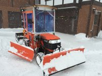
Indeed, it was great! I went out a little after 4 to plow for about 4 hours with my Kubota (see profile pic). It was sn+ and ++ until the change to sleet. There was almost no traffic on our main state thoroughfare at the time (Lawyers Road NW of Vienna) except the snow plows crawling by at about 10mph. They went by multiple times, 3 plows at a time, all just crawling. Never seen that before and no clue why the crawl, unless it's because they are on the clock.
-
Sad to hear about the wind stoppage. Was wondering what the conditions would be like given Snowshoe's orientation (from your description before since I haven't been there). Hope things break so you can get at least a few runs in. Now is where you could use some tele-skis. Can tele down, put skins on and hike back up. But it is a LOT of work. Maybe hanging out in the lodge is better.
-
Went out to plow at 4:15 and it was SN+ and 22F/21dp. Just came in 4 hours later and it's rain and 32. Was interesting to watch the conditions evolve from SN+ to sleet and now rn. For a while the roads were a disaster but as the temps approached freezing the ton of salt VDOT put down was quickly doing its thing... Overall, a pretty decent storm.
-
Will never forget it. Departed IAD on the first flight that went out after IAD opened that morning. Flew/moved to Bkk via Narita. IAD was mayhem. .
-
Not here just NW of Vienna. It's sn+ Was at 21F for several hours as the dp gradually rose to 20. Temp just went up to 22 and the dp is following suit at 21. Probably about 1"/hr now. Wind is still out NNE & NE here.
-
Just came out at 13:02 EST from NWS - KLWX https://www.weather.gov/lwx/winter DCZ001-MDZ005-006-008-011-503>508-VAZ052>055-502-506-170215-/O.CON.KLWX.WW.Y.0007.000000T0000Z-220117T0600Z/District of Columbia-Carroll-Northern Baltimore-Cecil-Southern Baltimore-Northwest Montgomery-Central and Southeast Montgomery-Northwest Howard-Central and Southeast Howard-Northwest Harford-Southeast Harford-Prince William/Manassas/Manassas Park-Fairfax-Arlington/Falls Church/Alexandria-Stafford-Southern Fauquier-Eastern Loudoun-102 PM EST Sun Jan 16 2022...WINTER WEATHER ADVISORY REMAINS IN EFFECT UNTIL 1 AM ESTMONDAY...* WHAT...Mixed precipitation. Snow accumulations of 2 to 4 incheswith locally higher amounts around 6 inches possible and iceaccumulations of around one tenth of an inch. Winds gusting ashigh as 45 mph.* WHERE...Portions of The District of Columbia, central, northcentral, northeast and northern Maryland and northern Virginia.* WHEN...From 1 PM this afternoon to 1 AM EST Monday.* IMPACTS...Plan on slippery road conditions.PRECAUTIONARY/PREPAREDNESS ACTIONS...Slow down and use caution while traveling.When venturing outside, watch your first few steps taken onsteps, sidewalks, and driveways, which could be icy and slippery,increasing your risk of a fall and injury.&&


