Bostonseminole
-
Posts
14,017 -
Joined
-
Last visited
Content Type
Profiles
Blogs
Forums
American Weather
Media Demo
Store
Gallery
Everything posted by Bostonseminole
-
84.6 .
-
2.79” event 0.83” today .
-
1.86” .
-
0.47 so far here .
-
This board never changes lol .
-
Flood watch up .
-
still expecting 2-4" here according to all models things don't get going till later.
-
AI GFS still going crazy with rain in boston metro
-
3K would make damage boy happy.. 50-60 gusts.. ?
-
3K much weaker and thus further north
-
18z nam looks north of 12z
-
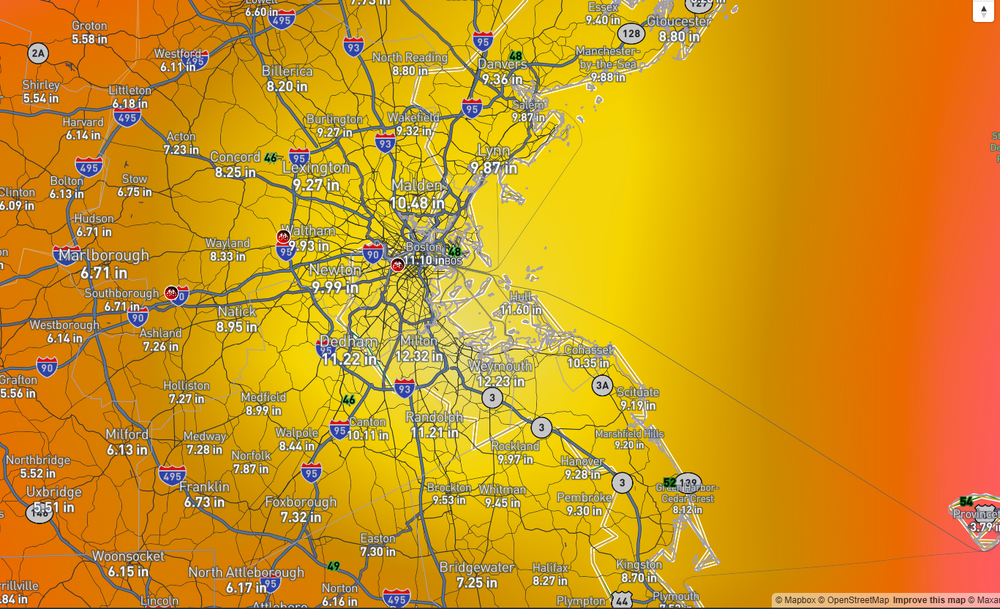
AI GFS lol
-
yikes.. hope you heal quickly
-
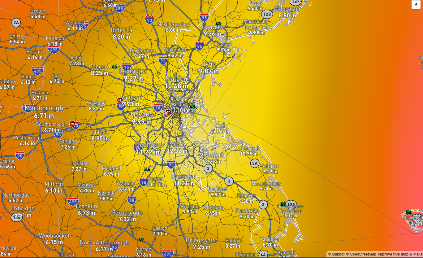
ICON still looks rainy here.. looks like almost 10" OF RAIN in Boston if my eyes are working!
-
so just getting back into this after years of boring foggy weather in CA.. anyone can tell me what is the RRFS model? any good?
-
I think it's still on the table imho
-
NAM 3K has it down to 976 at 45hrs, east of the NC/VA border
-
the nam might give you that
-
NAM is pretty far west..
-
HRRR looks pretty cool, but HRRR at 48 hrs.. so idk
-
511 WWUS71 KBOX 231933 NPWBOX URGENT - WEATHER MESSAGE National Weather Service Boston/Norton MA 333 PM EDT Wed Sep 23 2026 MAZ007-015-016-019>024-RIZ005>008-240900- /O.NEW.KBOX.HW.A.0003.260925T1200Z-260927T0000Z/ Eastern Essex MA-Suffolk MA-Eastern Norfolk MA-Eastern Plymouth MA-Southern Bristol MA-Southern Plymouth MA-Barnstable MA-Dukes MA-Nantucket MA-Bristol RI-Washington RI-Newport RI-Block Island RI- Including the cities of Plymouth, Bristol, Nantucket, Boston, Vineyard Haven, New Shoreham, Newport, New Bedford, Falmouth, Gloucester, Quincy, Mattapoisett, Chatham, Provincetown, Narragansett, Fall River, and Westerly 333 PM EDT Wed Sep 23 2026 ...HIGH WIND WATCH IN EFFECT FROM FRIDAY MORNING THROUGH SATURDAY EVENING... * WHAT...North winds 20 to 30 mph with gusts up to 50 mph possible. * WHERE...Portions of eastern, northeastern, and southeastern Massachusetts and northern and southern Rhode Island. * WHEN...From Friday morning through Saturday evening. * IMPACTS...Damaging winds could blow down trees and power lines. Power outages are possible. Travel could be difficult, especially for high profile vehicles. PRECAUTIONARY/PREPAREDNESS ACTIONS... Monitor the latest forecasts and warnings for updates. &&
-
yeah, pretty Meh
-
Euro still looks pretty good to me
-
yeah maybe 40-50 max gusts
-
drops 6-8 in boston metro.. cars underwater at storrow dr.