

Rtd208
-
Posts
12,679 -
Joined
-
Last visited
Content Type
Profiles
Blogs
Forums
American Weather
Media Demo
Store
Gallery
Posts posted by Rtd208
-
-
1 hour ago, jm1220 said:
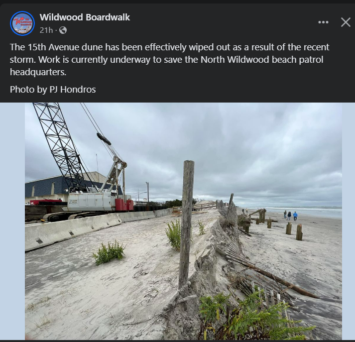
Beautiful in Long Beach, smoke cleared out thankfully. A COC day as they put it in the New England forum. The beach took a rough hit and possibly more to come @wdrag
35 minutes ago, wdrag said:Maybe bluewave or someone else with more energy than I would like to post how often are our weekends (Sat-Sun filled with 1" or greater rain since late June? Note sure the easiest way to track it, but you all are probably more up on this than I.
As you know, I've had to give up on the subtropical transition early this week as the reflux storm has tracked more se than South. However, I'm still interested in next weekend here and the following as well (7-8, 14-15). Both seem to have some sort of storminess here... whether it ends up just a 1/4-3/4" CFP, or something a little bigger with a coastal low... still tbd but I'm not done looking off the se coast for a little development later this week and northward ingest Saturday.
The EPS right now lags the ever amplifying GEFS into the eastern USA next Fri-Saturday. If its flatter, then just a windy cfp. If not, then gets a little more interesting fort a possible 1-3" event. Too early for me.
-
 1
1
-
-
59 minutes ago, Rtd208 said:
Just as an additional comment to my post above. If he is implying at this point it will be a warmer and snowless winter in the E US then he is no better then the ones he is posting about.
-
 7
7
-
-
-
11 minutes ago, SnoSki14 said:
October could be stormy after the first week with first taste Fri/Sat.
Also a non-zero chance we get some tropical influence from Philippe if the track shifts west.
But +PNA/-NAO and AO trending negative are stormy indicators.
Hopefully we get some good nor'easters cranking. We'll see.
-
1
-
 1
1
-
-
2 minutes ago, Stormlover74 said:
They don't listen or pay attention to things like flash flood watch. Also what difference would it have made? You can't stop the subways from flooding or be able to predict such an occurrence
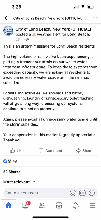
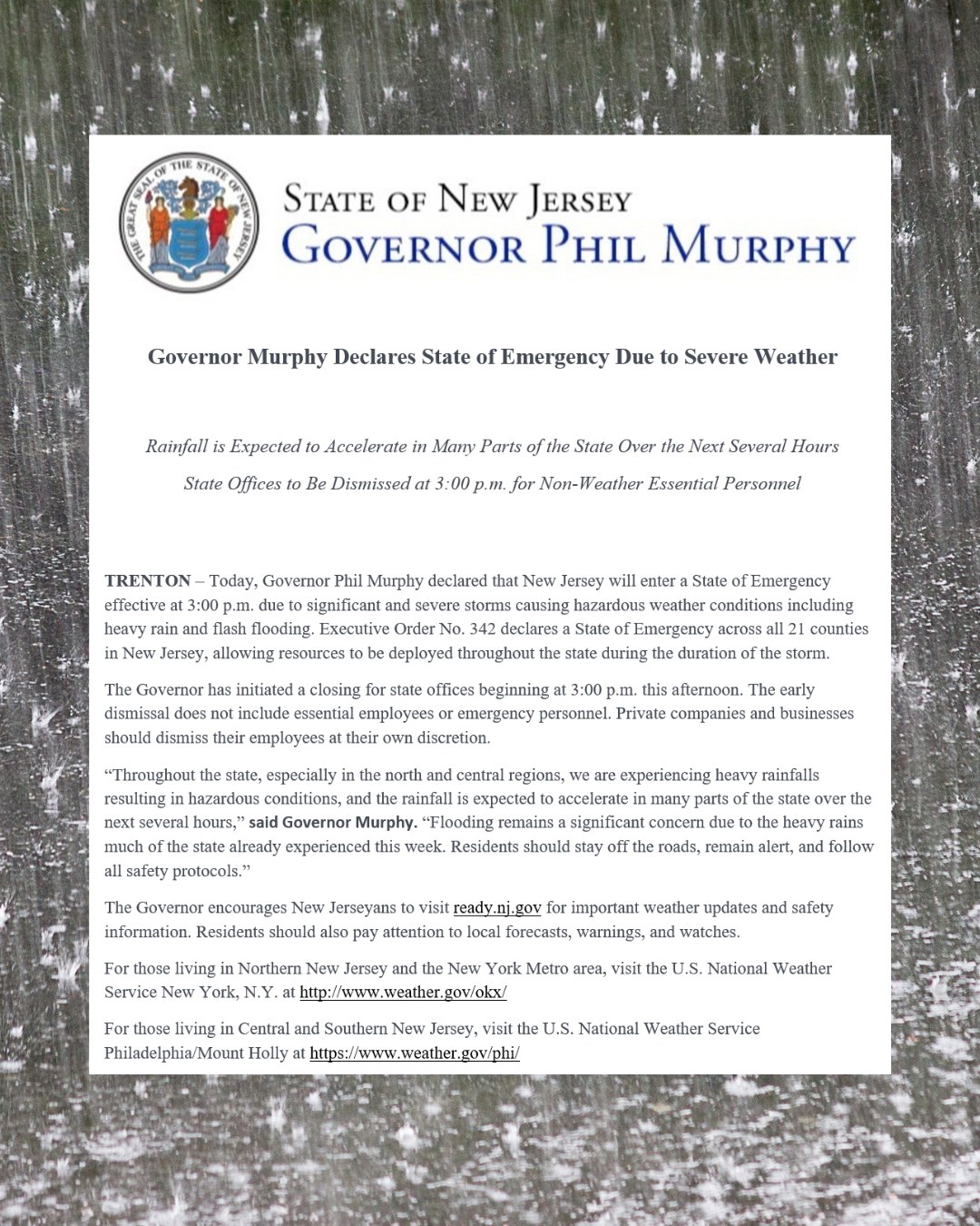
Part of the problem is what I mentioned in one of my previous posts about declaring a State of Emergency. Now in this particular case I think it was eventually a good call for the city and areas of SE NY State that were hit hard by the storm but not so much for NJ. The public does not take weather advisories and especially watches and warnings seriously anymore but part of that is because SOE's are being issued for 6-10" snowstorms which is ridiculous unless say the storm is expected to hit coastal communities hard with coastal flooding etc. Then you an SOE should be delcared for the counties that would be impacted the hardest.
For snow accumulations I don't think an SOE should even be considered unless the storm is expected to produce at least produce 12"+ of snowfall. The public not paying attention to watches and warnings etc. will continue to always be a dilemma for the weather and emergency management community IMO.
-
1
-
-
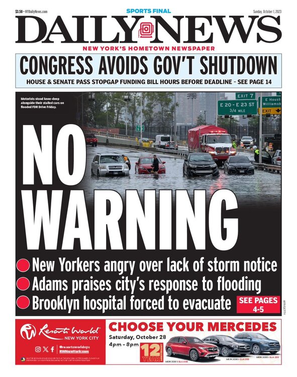
@wdrag New Yorkers angry at the lack of storm notice??

It seems like with every storm we always see the same thing "The public is angry about lack of storm notice"
Maybe its just the news media throwing fuel on the fire who knows.
-
1 minute ago, Dark Star said:
So a State of Emergency was put into effect for the entire state of New Jersey yesterday afternoon, after the heaviest of rains were over, which only affected the eastern most counties? Couldn't any simpleton declare that?
Its all about getting federal money for recovery. They issue SOE's when there is a stiff breeze these days, its ridiculous. I mean they are even issuing them for 6-10" snow storms, they never did that years ago. Its getting out of hand IMO. Issue a State of Emergency when its truly needed, no wonder why the public doesn't take it seriously.
-
3
-
-
Have to see if we pick up an additional rainfall today.
Storm total so far since Thursday 2.43"
-
Have to see if we pick up an additional rainfall today.
Storm total so far 2.43"
-
I have a little light rain falling here again.
Up to 2.15" of rain so far today.
Storm total so far 2.18"
-
I have a little light rain falling here again.
Up to 2.15" of rain so far today.
Storm total so far 2.18"
-
1
-
-
1 minute ago, SRRTA22 said:
Idk I think that's out to lunch for areas west of queens
If that is right that would even bring heavy rain back into portions of NE NJ as well. I am skeptical but we'll see.
-
-
1 minute ago, jm1220 said:
Uggh not good.
Definitely a bad time to take a poop.
-
 3
3
-
-
IMO this is basically done for areas west of the Hudson with msybe the exception of extreme NE NJ. We'll see.
-
3
-
-
1 minute ago, mikem81 said:
If only it was January.....

-
8
-
1
-
-
-
It does look like the rain is trying to expand back west of the Hudson River now so places in NE NJ may start to get back into some rainfall.
-
1 minute ago, WestBabylonWeather said:
Pivot!
.
-
1
-
2
-
-
The heavy rain in city has just been relentless.
-
1
-
-
-
Just now, jm1220 said:
State of emergency declared in NYC.
-
1
-
-
Not really sure how much rain we will see west of the Hudson River this afternoon. Everything seems to be concetrated to the east and that looks like it might continue. We'll see.
-
2
-
-
2 minutes ago, Stormlover74 said:
Quite the difference from me. I'm over 2"
Same. I am over 2" here as well.
-
1
-

October 2023
in New York City Metro
Posted
Gotta love the finger pointing, just fix the damn thing.