

WishingForWarmWeather
-
Posts
636 -
Joined
-
Last visited
Content Type
Profiles
Blogs
Forums
American Weather
Media Demo
Store
Gallery
Posts posted by WishingForWarmWeather
-
-
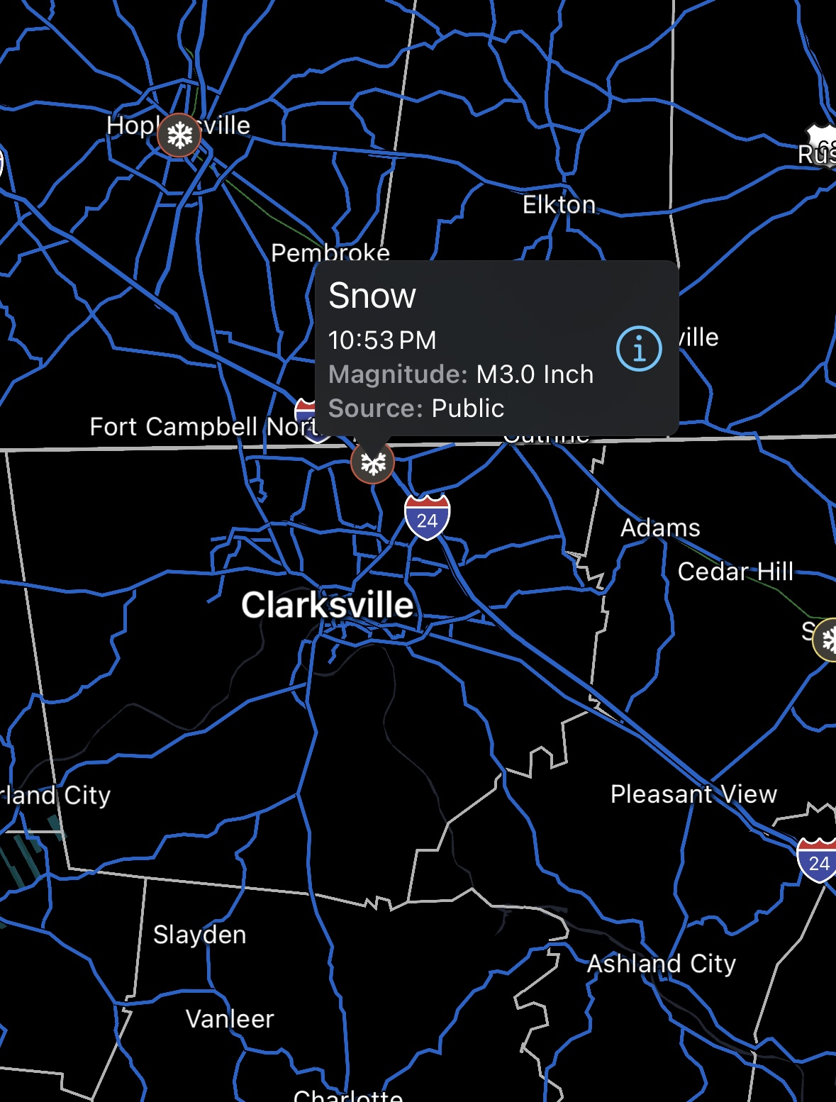
It’s randomly been snowing for the last hour, and radar looks like it will be going for another hour or so longer. Light snow, maybe 3/4 inch new but the roads are all covered again and it’s incredibly slick. Wasn’t expecting this, so it’s strange. School is canceled again tomorrow, but it was since about 10am today.
-Clarksville, 17° actual, 4° real, 12° DP, 81% humidity.-
 4
4
-
-
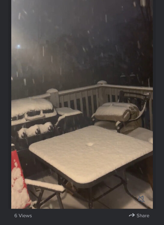
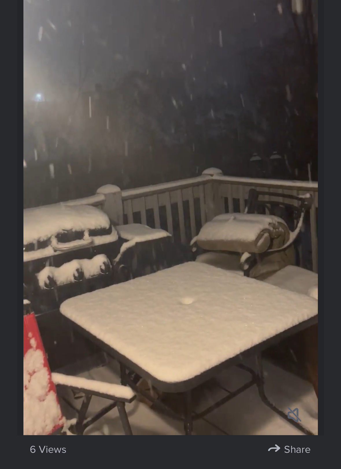
Final table shot.
-
2
-
 1
1
-
-
Clarksville snow picture.
22°, feels like 11°, says the low will be around 18° actual. 87% humidity.
-
3
-
-
35 minutes ago, PowellVolz said:
Ping report in Clarksville with 3”.
Yeah, easily. I will go grab a shot. Last one for tonight, brb.
-
56 minutes ago, PowellVolz said:
Hope no one gets hungry. lol.. just kidding
Well, if they do, we’ve got outside seating. Prime spot to watch the chef, though some complaints of ambient temperature.
-
2
-
 2
2
-
-
-
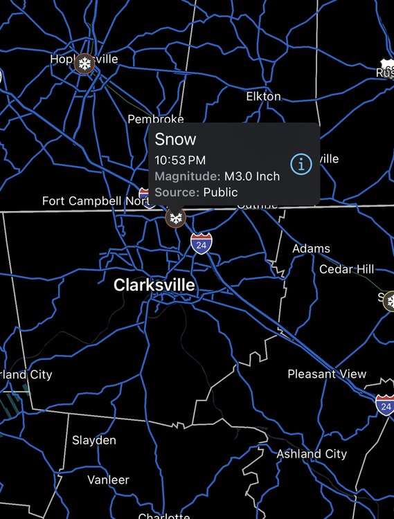
It is really really coming down here in Clarksville probably an inch already
-
5
-
1
-
-
39 minutes ago, Matthew70 said:
It’s a complete white out at the Tennessee Kentucky line at Clarksville. The interstates are already snow-covered.
You live here too? I’m like 3 minutes from the Kentucky line. Roads are solid white over here off Ft. Campbell.
-
2
-
-
For those who like video proof lol. Nothing special but I know yall.
-
5
-
1
-
-
Snow falling and already very lightly covering roads and grass in Clarksville.
edit to add the high at my house today was 31 and is currently 24 and dropping. Big ol flakes falling.
edit to add one more time. Last one I promise. I have a falling our 4-6 might bust low. Feels/smells in the air out there like the big ones I used to get back home in Jersey.
-
6
-
1
-
-
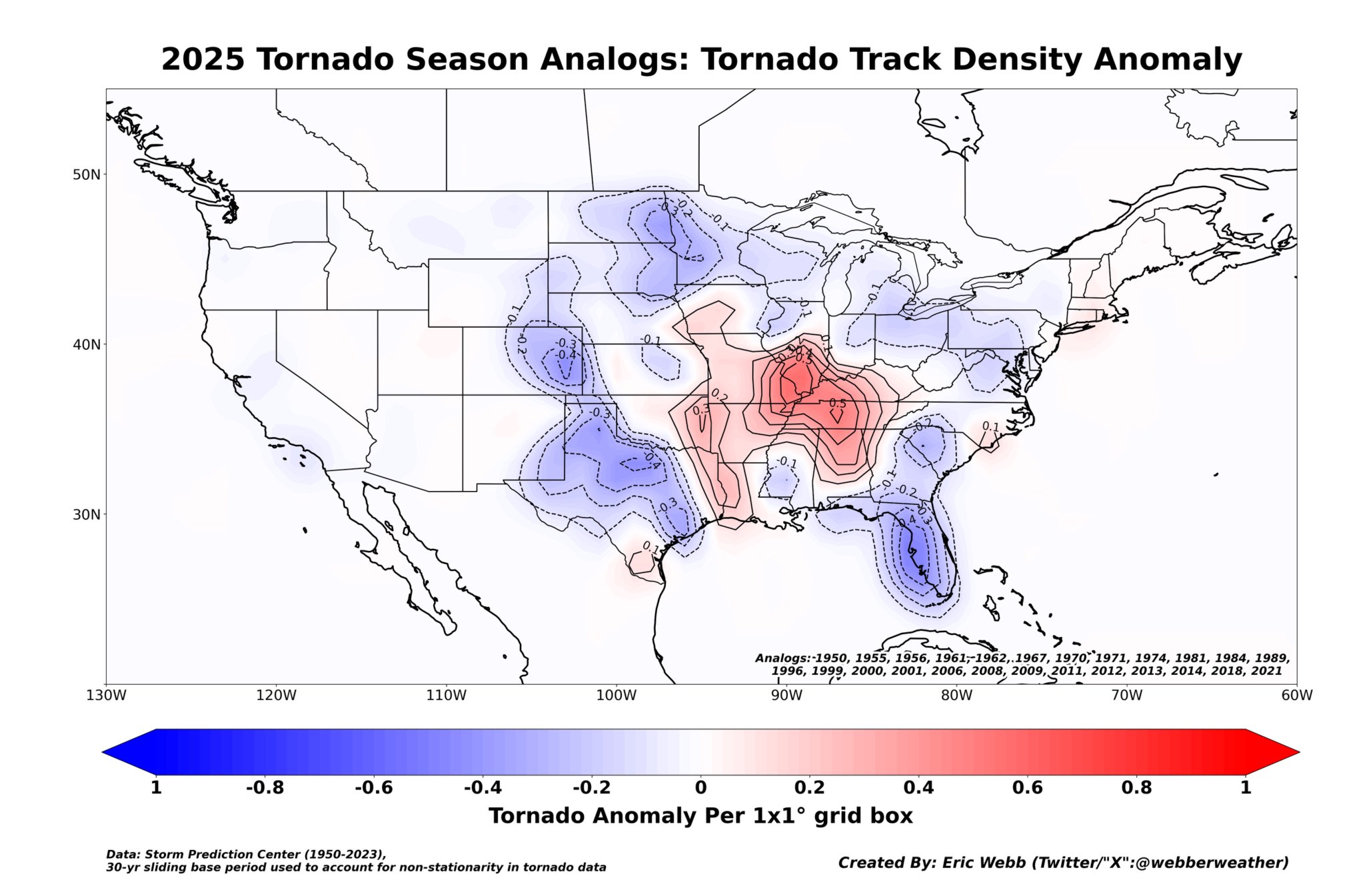
3 hours ago, *Flash* said:
I thought these were interesting. Note Nashville proper is one of the hot spots.
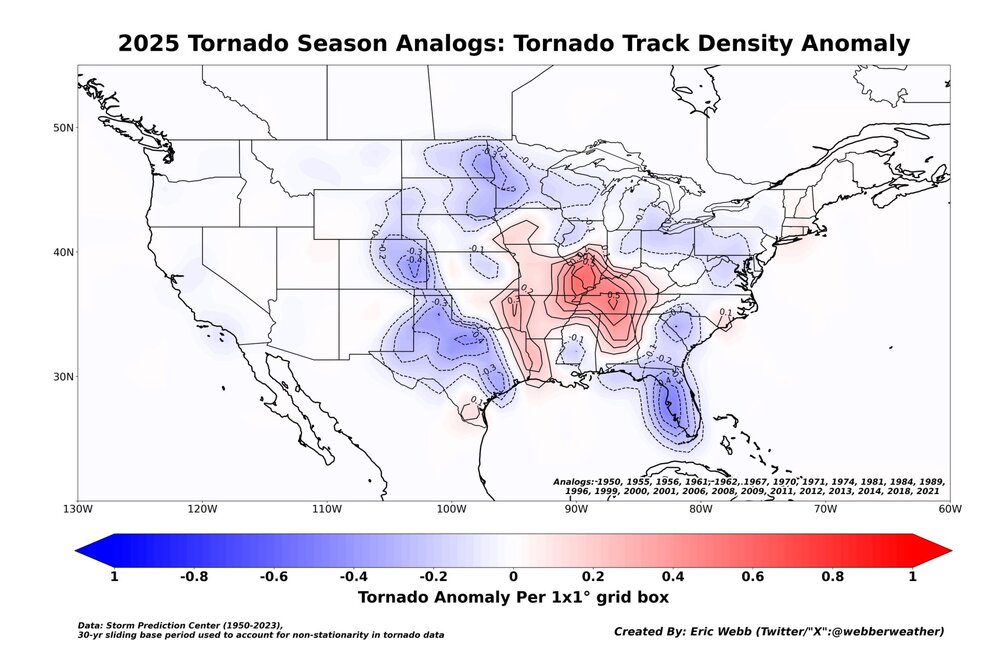
These are really interesting. Thanks for sharing.
-
3 hours ago, AMZ8990 said:
Winter storm watch is now up for all of west Tennessee as well.
Winter Storm Watch
URGENT - WINTER WEATHER MESSAGE
National Weather Service Memphis TN
238 PM CST Sun Feb 16 2025

...POTENTIALLY IMPACTFUL SNOW IS POSSIBLE NORTH OF INTERSTATE 40
TUESDAY EVENING THROUGH EARLY WEDNESDAY MORNING...

.A deepening upper level disturbance will move from the Great Plains
to the Midsouth and Lower Ohio River Valley by Tuesday night. This
feature will interact with Arctic air to bring potentially impactful
snowfall along and north of Interstate 40 Tuesday night.

ARZ027-035-036-TNZ049-050-052>055-088>090-171030-
/O.NEW.KMEG.WS.A.0002.250218T1800Z-250219T1800Z/
Poinsett-Cross-Crittenden-Tipton-Haywood-Madison-Chester-
Henderson-Decatur-Shelby-Fayette-Hardeman-
Including the cities of Collierville, Millington, Bolivar,
Jackson, Lexington, Parsons, Harrisburg, Covington, Bartlett,
Germantown, Wynne, Decaturville, Henderson, Memphis, West
Memphis, Somerville, Oakland, and Brownsville
238 PM CST Sun Feb 16 2025

...WINTER STORM WATCH IN EFFECT FROM TUESDAY AFTERNOON THROUGH
WEDNESDAY MORNING...

* WHAT...Heavy wet snow possible. Total snow accumulations between 1
  and 3 inches possible.

* WHERE...Portions of East Arkansas and West Tennessee.

* WHEN...From Tuesday afternoon through Wednesday morning.

* IMPACTS...Plan on slippery road conditions. The hazardous
  conditions could impact the Tuesday evening and Wednesday morning
  commutes.

PRECAUTIONARY/PREPAREDNESS ACTIONS...

Monitor the latest forecasts for updates on this situation.

&&
Interesting - maybe I just skim these or something but I can’t remember a time they described adjectives of the snow in a WSW. “Heavy, wet”
edit - just went to look at ours. Just says “heavy”. I guess mane the wet qualifier for the snow threw me off. Can’t remember seeing that before.
-
1
-
-
19 hours ago, John1122 said:
The temp has went up from 39 to 56 since 5pm. Heavy mist/drizzle going on out there. If that next line of storms/rain doesn't weaken, we're probably looking at some potentially life-threatening flooding for folks.
Our temp went from 45 at noon to 65 at midnight right before the torrential downpour came. Our river is flooding and will crest at 53/54 feet on Tuesday - not including any liquid from snow that evening.
In Clarksville. Cumberland River.-
3
-
 1
1
-
-
15 hours ago, Knoxtron said:

sorry I'm 8 years old apparently
Lmao it’s ok - as I was writing it I was like mmmm risky phrasing but we’re rocking with it
-
1
-
-
3 minutes ago, John1122 said:
It would be alot easier to stomach the heating bills with a big snow storm but at least there's some snow around out there.
This part
 we did get 2 inches very early Saturday morning. But the bitter cold with no fun snow to come with it is crappy. Knowing the low temperature tomorrow night is 3° and even lower with “real feel” makes me and my arthritic bones want to cry. We went through SO much wood last night. -sigh-
-
1
-
1
-
-
Central air unit kept trying to kick in aux heating all night. So we had to stay up and keep the fire going. What a brutal cold night here in Clarksville. Tomorrow night into Wednesday morning looks even colder than last night. No freaking thank you.
-
1
-
-
Not that it will verify exactly as is - but my forecast is for 60° on Friday. Wild. And then that cold front comes through and then Sunday has a low of 14° and Monday a high of 22°. My arthritis is begging for quick death.
-
1
-
-
1 hour ago, John1122 said:
I'm actually surprised the front is going to pass completely dry. Usually these 25+ degree drops squeeze out some snow. It's 40 here now and I'm supposed to get down to 12 tonight.
Was 50° yesterday here, 39° today, 18° tonight. Tomorrow is showing a 47° day, 17° night. Big swings. Heating system ~loooooves~ it.
-
2
-
-
23 hours ago, Uncle Nasty said:
Peachtree City is already mentioning 10 days down the road. The wording seems that they are mentioning it because everyone is already sharing huge storm totals on social media.

Area Forecast Discussion
National Weather Service Peachtree City GA
307 PM EST Sun Jan 12 2025
I feel like I`m having to do this too much for a meteorologist in Georgia, but let`s once again take a moment to discuss the potential for some winter weather middle of next week. Yet again, we are seeing a few of the operational models occasionally spit out a significant winter event for our area, giving some eye popping 10:1 snow maps ripe for slapping up on social media. With signs that we will have yet another significant Arctic front move through the area by the end of the week into early next week, we will certainly be in a set-up that *could*, once again, bring winter weather into the CWA. Cold air will be well into the Gulf, establishing a baroclinic zone along the coast, and there are signs of a shortwave that may be able to tap into that for surface low formation and have a decent connection to the subtropics to pull in some moisture. However, so far, of the 2-3 potential winter setups like this we`ve seen the models spit out this winter season, 1 has panned out. Getting all the ingredients in line at the right time in the right way is always tough here. To emphasize this, looking at ensemble model probabilities across the 12Z guidance for getting >1" of snow, the GEFS shows around 5%, the European ensemble around 10-15%, and the Canadian about 5% only in northern GA. Could it happen? Absolutely. These probabilities are certainly much higher than the typically probability of snow on a given day in the winter in Georgia (
Sent from my SM-S916U using Tapatalk
Whoever this forecaster is, I enjoy their writing/explanation style. This was perfect for folks who have little weather knowledge and folks who have a lot of weather knowledge lol.
-
3
-
-
5 hours ago, bearman said:
Send Pictures
So, they won’t upload. But I uploaded it to Imgur I just can’t figure out how to embed it so here’s a link to the video. Hopefully you can actually tell how big the flakes were bc honestly I feel like the video doesn’t do them justice at all. Some of these were for sure like half dollar sized. SNOW VIDEO! CLICK ME!
-
3
-
 1
1
-
 2
2
-
-
5 hours ago, bearman said:
Send Pictures
I can’t figure out how to show you
all I have is a video let me see if a screen shot of the video will actually attach. One moment!
-
4 hours ago, Reb said:
Forget potato chips, whole potatoes are falling out of the sky here
This was me earlier!! Only lasted like 10 min but I’ve never seen anything like it. It was amazing.
-
3
-
-
Literally the biggest snow flakes I’ve ever seen in my entire life falling for the past 20 minutes after really fine snow for a few hours. Clarksville TN.
-
6
-
1
-
-
52 minutes ago, housemtnTN said:
Radar has shown light snow for hours here in mascot but I haven't seen a single snowflake lol.
That was sadly like me this morning. Radar returns from 3-6 but not a single flake to be seen. Then we went to big thick fattys. Then fine. Now back to thicker ones with reaaaal big boys mixed in. Clarksville, TN.
-
4
-

TV Severe Weather2025-?
in Tennessee Valley
Posted
Andy would you mind posting that if you’re able? I apologize, I don’t know where to go to see this.