

Solak
-
Posts
6,434 -
Joined
-
Last visited
Content Type
Profiles
Blogs
Forums
American Weather
Media Demo
Store
Gallery
Posts posted by Solak
-
-
Wasn't expecting this this evening...
806 PM EDT Mon May 4 2020 The National Weather Service in Greenville-Spartanburg has issued a * Tornado Warning for... Southern Spartanburg County in Upstate South Carolina... * Until 830 PM EDT. * At 805 PM EDT, a severe thunderstorm capable of producing a tornado was located 11 miles southwest of Spartanburg, or near Moore, moving southeast at 20 mph. HAZARD...Tornado and tennis ball size hail. SOURCE...Radar indicated rotation. IMPACT...Flying debris will be dangerous to those caught without shelter. Mobile homes will be damaged or destroyed. Damage to roofs, windows, and vehicles will occur. Tree damage is likely. * This dangerous storm will be near... Woodruff and Moore around 810 PM EDT. Other locations impacted by this dangerous thunderstorm include Enoree and Pauline. -
Starting the day with a crisp 44 degrees. Missed out on yesterday's scattered sprinkles.
-
1.98 storm total yesterday. Still don't understand how, by CoCoRaHS standards, most of that (1.73 that fell between 7-noon) counts as May precipitation. Their game, their rules.
-
Today we announce the retirement of senior hurricane specialist Dr. Lixion Avila. "Lix" issued countless forecasts for hurricanes that included names like Gilbert, Andrew, Katrina, Wilma, Michael and Dorian. Now after 33 years of federal service, all of it at the National Hurricane Center, he's ready to enjoy the next chapter in his life. We will miss our friend and colleague, and wish him well!
In this interview, he reflects on his career at NHC: https://www.weather.gov/careers/meteorology-avila-lixion
-
Wow! Lucky!
-
A chilly 41 to start the day.
-
9 hours ago, vortmax said:
What's the timing? We're flying out of HHH Thu early AM. Will the front be through by then? I think the Euro is the slowest.
From RAH:
Models continue to suggest a quick hitting round of convection
capable of producing heavy rain and possibly strong to severe
thunderstorms moving into central NC from the west Wednesday
evening, through the area Wednesday night/early Thursday and
offshore by Thursday evening.
-
 1
1
-
-
Any snow/sleet/graupel in the southern mtns along the TN border? Seeing some 'pink' returns on radar.
-
1
-
-
EF-2 in Greenville County, SC last night.
...NWS DAMAGE SURVEY FOR 04/25/20 TORNADO EVENT...

.20200425_wadehampton...

Start Location...3 N Greenville in Greenville County SC
End Location...3 SSE Taylors in Greenville County SC
Date...04/25/2020
Estimated Time...09:09 PM EDT
Maximum EF-Scale Rating...EF2
Estimated Maximum Wind Speed...115 mph
Maximum Path Width...200.0 yards
Path Length...5.54 miles
Beginning Lat/Lon...34.8916 / -82.3915
Ending Lat/Lon...34.8782 / -82.2974
* Fatalities...0
* Injuries...0

...Summary...
An EF2 tornado touched down just east of the Montebello
subdivision in central Greenville County. Initial damage
consisted mainly of large tree limbs broken, but the tornado
intensified and uprooted trees and snapped numerous tree trunks
as it approached and ran along Pleasantburg Dr. The tornado
reached its peak intensity of 115 mph and width of close to
400 yards for the first time after crossing Rutherford Rd, where
it lifted the roof off a motel in the Forest Hills area, snapped
numerous hardwood tree trunks, and threw the roofing material a
good distance, destroying numerous cars. The tornado continued to
snap and uproot trees as it moved parallel to Brushy Creek and
crossed Wade Hampton Blvd, where it lifted much of the roof off a
restaurant and damaged the SAVMOR building. The tornado then
continued moving eastward and winds reached peak intensity of
115 mph again as it crossed Edwards Rd, where it snapped and
uprooted multiple hardwood trees. In addition, the tornado
debarked many of these trees. The tornado kept going towards
Botany Rd, where it damaged a church building and snapped more
trees. The tornado then crossed E. North St. where it weakened,
snapping numerous tree limbs before lifting just before reaching
Hudson Rd.
-
0.02" overnight.
-
Pretty amazing how long these 3 cells remained intact
-
And another...
750 PM EDT Sat Apr 25 2020

The National Weather Service in Greenville-Spartanburg has issued a

* Tornado Warning for...
  Northeastern Rabun County in northeastern Georgia...
  Southeastern Macon County in western North Carolina...
  Northwestern Oconee County in Upstate South Carolina...

* Until 815 PM EDT.

* At 749 PM EDT, a severe thunderstorm capable of producing a tornado
  was located near Clayton, moving east at 40 mph.
-
Tornado Warning
National Weather Service Greenville-Spartanburg SC
740 PM EDT Sat Apr 25 2020

The National Weather Service in Greenville-Spartanburg has issued a

* Tornado Warning for...
  Northeastern Greenville County in Upstate South Carolina...
  Northwestern Spartanburg County in Upstate South Carolina...

* Until 815 PM EDT.

* At 740 PM EDT, a severe thunderstorm capable of producing a tornado
  was located 8 miles north of Greenville Downtown, or near Paris
  Mountain State Park, moving east at 40 mph.
-
0.10" on Thursday.
-
Also on the bright side, it also tempers the chance of severe weather, at least for 'our' area.
-
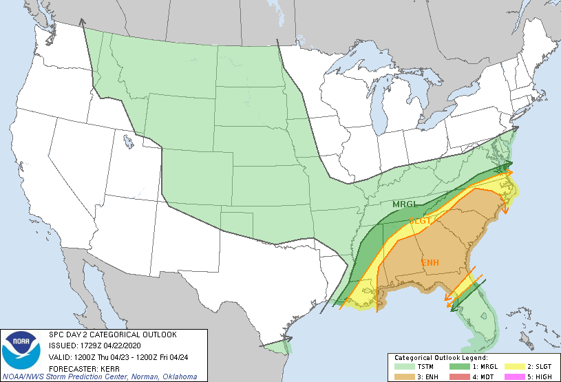
New day 2
-
Boy, the GFS has really cut back on precipitation amounts for the next 2 systems. (RDU area). Now just showing 0.20 for Thursday, and 0.12 for the weekend event. Meanwhile, NWS is still calling for over an inch for tomorrow/tomorrow night. NAM 12z drops 2.38" tomorrow. So, I'm going to go out on a limb and say we'll probably get some rain, and it could be a little, or could be a lot.
-
 2
2
-
-
1 hour ago, magpiemaniac said:
The April 19th Severe Event thread is full of interlopers I’ve never seen before. It’s the weather equivalent to rubbernecking. I appreciate the insight from several of them. Others, not so much.
I guess if the storms won't come to them, they flock to the storms. 4/12 was the same way. Lots of new 'faces' in the forum.
-
down to 33 this morning. Chilly!
-
Picked up 0.25" overnight. temp dropped from 64 at 1:15AM to currently 44 at 8:15AM
-
Big winds overnight/morning hours for central NC.
Widespread and frequent wind gusts between 35 and 50 mph are likely
late tonight through midday to early afternoon Monday; and these
will impact all of cntl NC both within and away from convection/
precipitation. Scattered to numerous gusts between 50-60 mph are
also expected, with isolated ones in excess of 60 mph; and this may
necessitate upgrade to a High Wind Warning.

While not as widespread as the background flow and gusts noted
above, convection will focus narrow corridors of intense, damaging
wind gusts in excess of hurricane force (74 mph), as well as
isolated tornadoes - one or two of which could be significant (EF2
or greater).
-
 1
1
-
-
Central NC specific from latest RAH AFD.
The severe threat is looking increasingly alarming. IMO the most
remarkable/concerning aspect is the HREF high probabilities(80-90%)
that show moderate instability(1000-1500 J/Kg) spreading west to
east across central NC, amidst the large 0-1 km hodographs and 400-
500 m/s of helicity created by the incredibly strong low-level shear
moving through the region. This environment will be highly conducive
for widespread thunderstorm wind damage, tornadoes and large hail
across the area between 09Z(4am) to 16z(Noon), with the pending of
evolution/mode of the convection(line/bow segment vs. discrete
supercells) playing a critical role in what the main severe threat
will be.
-
3
-
-
New day 3
-
2
-
-
Dropped down to 32 overnight. Brrrrr!
May Observations
in Southeastern States
Posted
0.08" last night.