

Hvward
-
Posts
3,431 -
Joined
-
Last visited
Content Type
Profiles
Blogs
Forums
American Weather
Media Demo
Store
Gallery
Everything posted by Hvward
-

The December to Remember 7th-8th blue turd winter threat thread.
Hvward replied to lilj4425's topic in Southeastern States
6z NAVGEM Total Precip through hr 84. Looks to be all frozen in a least the mountains and foothills. One can wish right? NAVGEM hasn't let down though. -
The December to Remember 7th-8th blue turd winter threat thread.
Hvward replied to lilj4425's topic in Southeastern States
6z NAVGEM still sharpening the base of the trough and absolutely hammer the western part of NC. Looks good for Upstate SC and parts of NE GA as well. RDU to CLT could be the battleground (of course). -
The December to Remember 7th-8th blue turd winter threat thread.
Hvward replied to lilj4425's topic in Southeastern States
Been watching the NAVGEM for the past few days and it has been pretty consistent (minus on run yesterday) with the LP being captured hanging right off the coast. Showed a deformation feature Monday afternoon. Monday 18z Wednesday 00z -
Sunrise and the beginning of leaf season on the Blue Ridge Parkway from Craggy Pinnacle
-
-
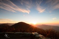
From the album: Fall in WNC
Sunrise over Craggy Pinnacle, NC -
Craggy Pinnacle Sunrise WNC Blue Ridge Parkway
Hvward posted a gallery image in Members Albums Category
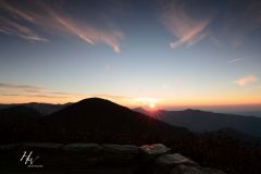
From the album: Fall in WNC
Sunrise over Craggy Pinnacle off the Blue Ridge Parkway in Western North Carolina.
