

buckeye
-
Posts
8,655 -
Joined
Content Type
Profiles
Blogs
Forums
American Weather
Media Demo
Store
Gallery
Posts posted by buckeye
-
-
pretty confident once we go to snow we stay snow
-
 1
1
-
-
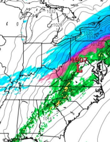
slop/snow line.... as it sinks southeast that moisture down in TN should skirt along with it moving northeast and there should be a nice zone of snow setting up nearby.

-
1
-
-
5 minutes ago, pondo1000 said:
It’s how I cope. LOL
Plus, it helps to have optimistic Buckeye! LOL
not picking on you guys....i totally get the frustration.
-
3 minutes ago, Dustin said:
It's amazing how much panic there is in this thread from members who the HRRR show picking up 8-10 inches over the next 24 hours.
Thinking there's going to be a narrow zone of deformation in the early AM hours that is really going to rip. Still, the HRRR forecast sounding along that line bring the warm tongue right to the 0C isotherm, and the HRRR and GFS certainly missed the depth and intensity of the warm layer this morning. If you look at ILNs sounding from this morning, and check out the NAM's soundings from yesterday's run, it modelled the column incredibly well for today. Those who are upset or not understanding the extent of ZR and sleet this afternoon selectively choose to ignore that in the modelling and sampling. Did we get rid of the weenie tag?
thank you
back in the old'n days of posting they would ban posters who would make posts that were all whines and woe- is-me and who cancelled the storm in the first quarter. I mean I get it, I love snow too and yes I would be disappointed if 90% fell as sleet but nothing we can do about it and all the ranting and complaining ain't gonna change that.
This is a dynamic set up, yes, it could turn into sleetfest '22 for some including me, or we could get sleet followed by a really nice thump, (which I think is more likely). But I'll sit back, watch it unfold and let the weather do it's thing.
-
2 minutes ago, pondo1000 said:
Powell, but next to the zoo so very close to Dublin
just checked the cameras at my office in lewis center and still very light there too
-
2 minutes ago, pondo1000 said:
It’s sleeting so hard here it almost looks like snow!
you're in dublin right? One thing that has surprised me so far is how light the sleet has been here.
-
this is the latest hrrr, it's the 18hr panel, (5am), that's 16 hrs from now. None of us know for sure what the sleet to snow ratio is going to end up. Feb sleet storm was always on the table but so is a nice snow storm. More likely a combination that would make us happy to have any other time. Relax and enjoy the tracking, otherwise why the hell are we here.
x
I
-
1
-
-
4 hours ago, dilly84 said:
I'm just not seeing it. We need the cold to shift se about 20 miles to get close to this and soon.
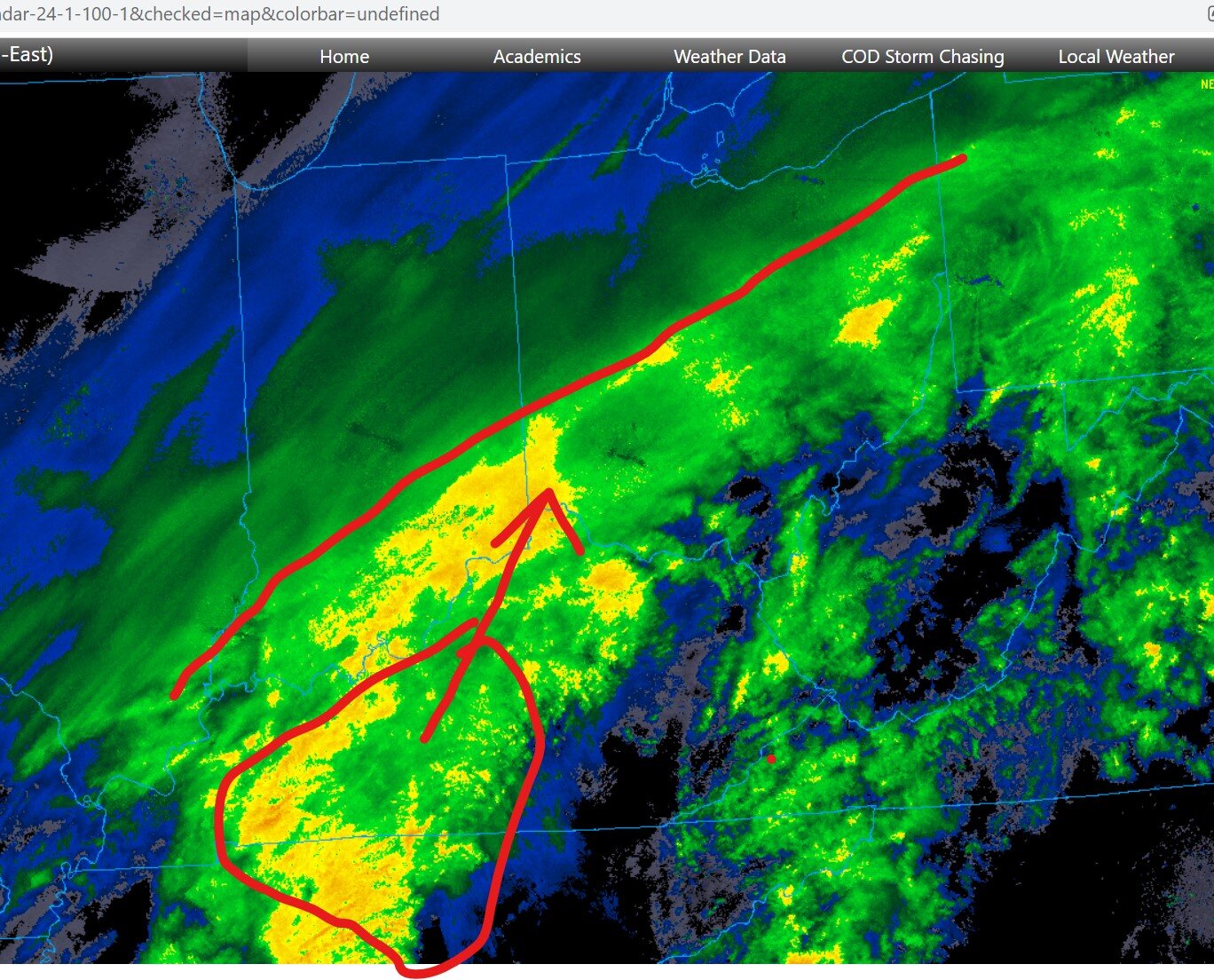
you're where the red dot is, we got a little time
-
2 minutes ago, Cincy12 said:
I’ll keep you posted 5 minutes away from the river, sleet has picked up a bit
thanks, let us know if we need a helmet or a shovel
-
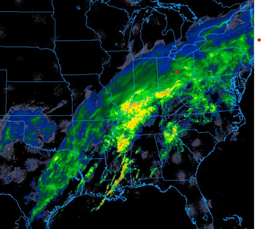
Toledo is reporting haze and 23. I wanted to see if the radar was true what it was showing and it apparently is. Looks like the precip is having a tough time getting into nw ohio and northern/northeastern IN. Looks like it's hitting dry air. Might be good sign for us
-
1
-
-
16 minutes ago, pondo1000 said:
Awesome sleet storm just like last February! Yay!
actually a pretty pultry sleet storm for here all morning. At least it's not pounding sleet, so I don't feel like I'm losing a ton of qpf to sleet. The precip along the ohio river moving towards cincy is what to look out for.
-
Definitely can see the push of cold dry air across IL and nw IN. Best precip still well sw of us.
-
I think back to some of our classic busts due to more mix and less snow then forecast, it seems many started out as a brief period of snow that transitioned to sleet. We are going through a slow transition of rain to frz rain to sleet and now we wait for snow.
-
2 minutes ago, dilly84 said:
Hes so optimistic he's sharing his own post lol
pessimism is easy....optimism takes sack, (especially when it comes to winter storms in CMH)

-
1
-
 1
1
-
-
Just now, buckeye said:
I'm way more optimistic then some of you. Even if it's early afternoon before all snow, the snow should be falling at a good rate on base of ice and sleet. Also, the nam and some other models are beginning to show a longer duration with more energy lagging on the tail end.
patience grasshoppers
-
I'm way more optimistic then some of you. Even if it's early afternoon before all snow, the snow should be falling at a good rate an base of ice and sleet. Also, the nam and some other models are beginning to show a longer duration with more energy lagging on the tail end.
patience grasshoppers
-
1
-
-
10 minutes ago, pondo1000 said:
Score 1 for the RGEM I guess. I’m calling it…TOD…8:12 AM
8 minutes ago, dilly84 said:Kinda funny that nws upped their totals. I mean if it's still sleeting in by 10am that's when I'll officially call it.
Thank god you guys aren't ER doctors
-
3
-
-
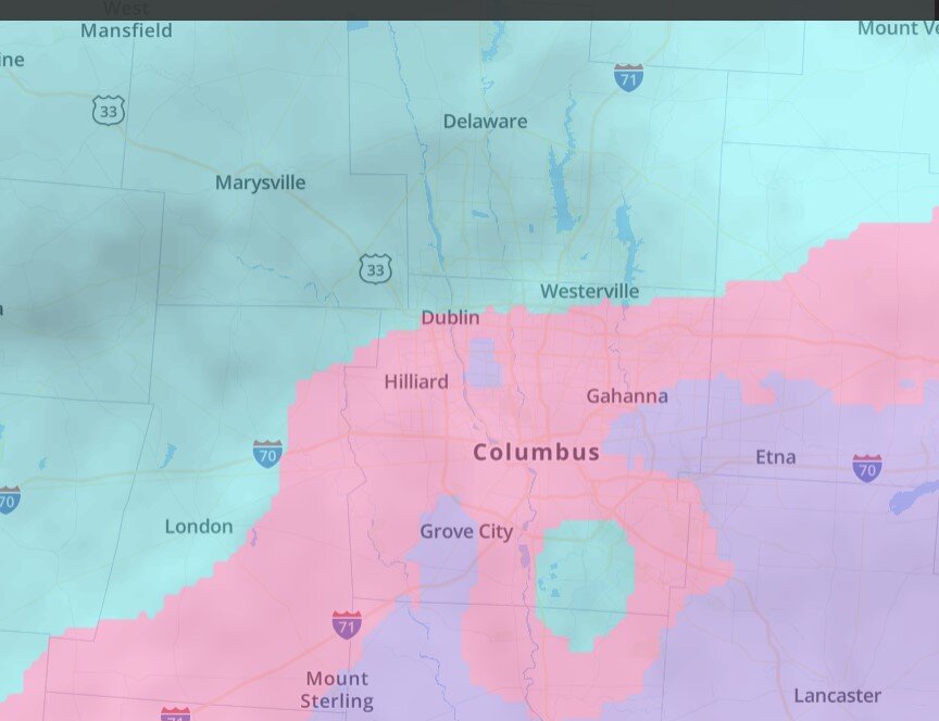
currently but not necessarily accurate. I'm just north of where it says westerville
-
Light sleet light freezing rain. Opened front door and sounds like a giant bowl of rice krispies.
-
9 minutes ago, dilly84 said:
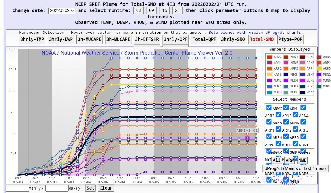
Sref plumes. Several members over 10"

How's that been trending?
-
34 minutes ago, pondo1000 said:
Manitoba Mauler?
-
1
-
-
I'll be sleeping very lightly with my radar handy on my phone and this forum open. Looks like timeline is between 1 and 4 am for the change from liquid to frozen, then the million dollar question is when the frozen turns to flakes. I've seen some models have it as early as 5am and of course we have the rgem that really never changes over to all snow until evening.
If it's snowing at 6am, we'll be in very good shape.
-
1
-
-
1 minute ago, pondo1000 said:
18z bad?
same, just doesn't want to change to snow....perpetual sleet/frz rain. Rgem is usually a decent short range model but can definitely have a warm bias in the very near term....hoping that's the issue

-
 1
1
-
-
I still feel pretty good but I'd feel better if the rgem starts to play ball at 00z
Quote
“Let’s Talk Winter”
in Lakes/Ohio Valley
Posted
agree, precip all the way back to arkansas