

buckeye
-
Posts
8,655 -
Joined
Content Type
Profiles
Blogs
Forums
American Weather
Media Demo
Store
Gallery
Posts posted by buckeye
-
-
miserable spring wx
-
 3
3
-
 1
1
-
 1
1
-
-
On 3/7/2022 at 5:40 PM, buckeye said:
Let's see how it looks in 48 hrs.
Well, I guess it's been 72 hrs. Barring any last minute shift to a deeper, more negatively-tilted trough, this looks like a glorified frontal passage with advisory snow overnight Friday into Saturday. Considering it's March.....yawn.
-
6 hours ago, WestMichigan said:
Which is it, bring it on, or no more snow?
those aren't the same "S's"
-
17 minutes ago, jaf316 said:
Hellloooo! Anyone here?
I imagine everyone's already in spring mode, but some of the models are suggesting one last winter hurrah this weekend. Not sure I buy it yet, but could be a quick hit of heavy snow Friday night/Saturday. Latest gfs shows 10 inches for Columbus :). I know, I know...
Let's see how it looks in 48 hrs.
-
3
-
-
temps busted cold today, didn't get above freezing. I think the freezing rain threat is looking more likely now...low level cold air is going to be hard to dislodge, especially without a strong low pushing the warm tongue. Hope it turns out to be the usual freezing rain event around here which is usually pretty harmless.
-
That lull between the first batch of light precip and the bigger follow up batch is what allows levels to warm enough to keep us from getting a slop fest. By the time that second batch comes in it's rain.
This one doesn't bother me. It's a crap storm overall even in the snow sector... no one is getting 'buried'.
-
1 hour ago, dilly84 said:
It's ohio. It can be 15° and warm tongue us. This one is gonna hopefully end up being mostly sleet instead if freezing rain, but I have a feeling we're gonna see significant zr.
last minute trends are for warmer air winning out. Franklin county might be primarily rain.....which is fine with me if the only other choice is sleet/frz rain.
-
1
-
-
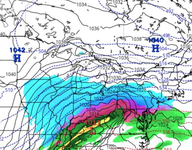
if a 1011 low in south central KY with a fresh 1040 banana high sprawled out north of us can still warm tongue us, we might as well give up.
-
Too early to call. We have a rain storm that has to go first. My gut says this trends southeast. Another positively tilted trough opening up as it heads east with a fairly weak storm/wave riding the front. Also pretty decent banana high in place.
I just saw the 12zUkmet just crushed the storm into nonexistence.
-
12 hours ago, chuckster2012 said:
Yeah, same here. Looks like two chances in about a week but who knows atp..?
Looks like there is an initial storm around Tuesday that will be a rainer for most.... it's what happens after that. All the models are showing that once the first storm goes through the baroclinic zone sinks south of us and the gulf opens up again. Looks like a possible chance of a nice overrunning event later next week. 6z euro ens shows this as well now.
All caveats are possible.... if return flow is stronger with a stronger low, we warm tongue.... if front pushes further south we smoke cirrus. I'm feeling good for something wintry, hopefully not ice though.
-
2
-
-
4 hours ago, Spartman said:
We may very well be returning back to a milder pattern towards the final week of this month.

-
1
-
-
Next weekend might be our next system to watch. All models are trying to put something together....euro looks interesting. Hopefully we're tracking again by Tuesday.
-
1 hour ago, jaf316 said:
Well, I thought this was finally gonna be the one to put cmh over 6 inches for the first time in years. But alas...
A little disappointed in the final result for mby, but still a fun one to track. My take-away: don't underestimate the NAM when it come to p-type issues. It has a knack for sniffing out those thermal layers...
Airport and Bexley are on the eastside which made a huge difference. Big difference in totals from nw Franklin county to se Franklin county.
Interestingly my daughter and her fiance came in from Clinton township Michigan which is north of Detroit and they said we have more snow then them.
-
2 hours ago, dilly84 said:
Apple Valley Lake frozen over and snow covered
Nice pics. I'll be kind and not bump those first few posts from you and pondo yesterday morning

So now it's time for the post tracking blues made worse by an extended that has nothing but cold and dry for the next 10 days. I hear JB says winter dies in 3 weeks. If he's saying it, it's probably a good bet since he never forecasts winter's end this early. I'm ok with that, AS LONG AS WE GO ABOVE NORMAL TEMPS. CAD in late Feb into spring is miserable.
-
little bit of a lull right now.....light snow and light pingers
-
9 minutes ago, JayPSU said:
No, I’m in the south side of Westerville in Blendon Township.
oh you're not very far from me. You aren't all sleet are you? I just took my dog out and I could definitely feel the sting of the ping in the snow falling.
-
Just now, JayPSU said:
Yep, it’s already halting progress NW and should move back SE. Just frustrating is all. Looking like 6” is doable.
Yea if you're in Bexley makes sense since it's eastside of downtown.... it'll switch back. Still lot of qpf on the way
")
-
4 minutes ago, JayPSU said:
Back to sleet here. Talk about testing one’s patience.
Pretty sure we have some taint in there too. Hrrr showed a potential msnow to mix. Shouldn't last too long.
-
1 minute ago, pondo1000 said:
Kidding!!! I’m giddy! Enjoy everyone!
full on snowstorm here.... finally nice to see it this winter
-
2
-
-
1 minute ago, pondo1000 said:
Sleet again
ugh, it's ripping in westerville
-
7 minutes ago, Ji said:41 minutes ago, buckeye said:first flakes mixing in westerville
How much snow you expecting?
good question, I haven't even checked. Last I saw it was 3-7. The way the models have handled this it's all radar from here out.
-
1
-
-
all snow in westerville, I feel like I've been in line at the bmv all day and they finally called my number
-
3
-
 1
1
-
-
first flakes mixing in westerville
-
3
-
-
Pondo should be up next, I think he's the farthest nw in Columbus vicinity.....
don't disappoint us buddy!
-
1
-
Occasional Thoughts on Climate Change
in Climate Change
Posted
I wish there was a way we could punish volcanos for their utter disregard of the enviornment.