

CoralRed
-
Posts
383 -
Joined
-
Last visited
Content Type
Profiles
Blogs
Forums
American Weather
Media Demo
Store
Gallery
Posts posted by CoralRed
-
-
Williamsport itself and not just nearby locations finally got about an inch and a half of rain. Maybe since we got this, we can actually get some more of the rain predicted to come our way.
On the other hand I would be happy not to get the smoke coming down from Canada into the West which is supposed to eventually hit NYC. But I can't see how we can escape when we are between Ohio and NYC.
-
 2
2
-
-
2 hours ago, TheDreamTraveler said:
I've been super interested in how powerful this El Nino gets since we might get a Super El Nino that rivals 2015-2016. Should be interesting
"And to get an idea of just how massive the developing El Niño could be, the previous record high super El Niño peaked at 2.6°C in November/December of 2015. The 1997 El Niño peaked at 2.4°C. And this one is now modelled by the BoM to break 3.0°C."
Jesus christ lol
As I just said here the other day, I am interested in weather but I am no weenie. But between this, the ice reductions in Arctic & Antarctica & the smoke, I am now seeing a lot more professors & smart ppl appearing to be having fits on the inside while trying to stay calm on the outside, expressing worry and even screaming. I have followed a few so that is one reason I see more but still.... I do not like the trends even though there is so much I do not personally really understand. Just keeping up with basics a challenge.
I am so grateful we are in PA where the extremes are far less extreme than in many other places.
Oh yeah, you may be interested in something else from my Twitter reading today. I saw that we, Australia and I think it was Japan have different rules about El Ninos. We are the ones who make it easier to declare El Nino conditions than Australia. Another thing to think about here.
-
1
-
-
I just saw this on Twitter about El Nino and thought people would be interested:
"Wow!
The Australian Bureau of Meteorology has had both the most extreme and most accurate forecasts of the developing El Niño. But this forecast, just released, is so extreme it's hard to believe I'm seeing it.
3.0°C by October.
3.2°C by November."
Chart at link
https://twitter.com/EliotJacobson/status/1671213699875622914?s=20
-
1
-
-
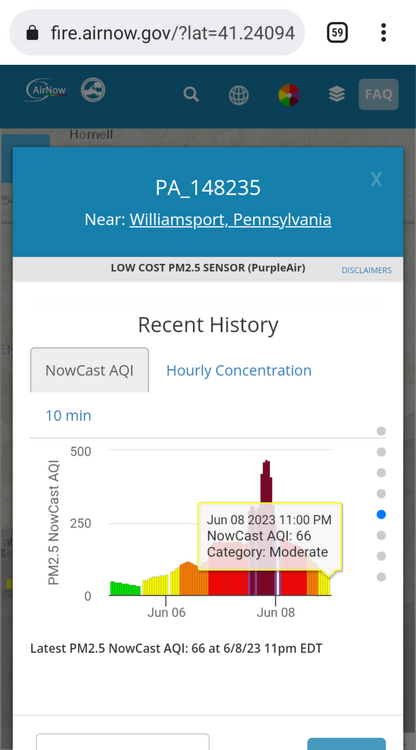
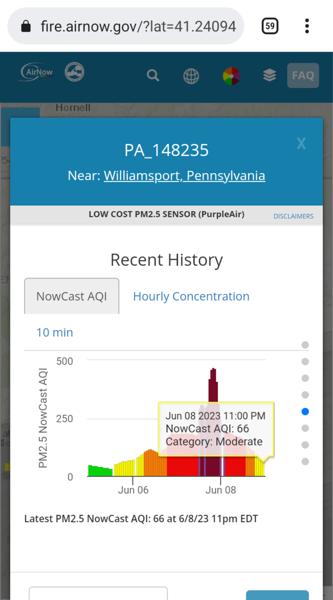
Williamsport is not doing so well with air. It is up to 151 and in the red zone. I could smell the smoke very faintly outside just now. I thought we would need more than 151 for that.
On rain, we are supposed to have some every day from Thursday-next Tuesday, two days with about half an inch for a total of around 2". I hope so but I am skeptical we will see all that given the amount of disappointments we have had.
I also just looked at my screenshots for the days we had such awful air. I can hardly believe we got that bad, but we did.
-
2 hours ago, Wmsptwx said:
We need rain bad
We sure do. I wonder when we will get more than a bit here and there, and not just once? Others to our east and south have in the past few weeks but not us. Some thunderstorms would help, too. I see temps are going up which will I assume will dry out the soil even faster.
-
What a surprise. We were only 62 around noon and are still only 68 at Montoursville Airport. I am used to temperatures being lower than average now. It will be a shock to my system when we get normal sticky summer weather. In the meantime, I am really enjoying what we have. I am sorry about the drought but am more than ready to enjoy lots more sunny days for as long as they last.
-
11 minutes ago, Jns2183 said:
My brother's friend in India measured with legit scientific instruments 97 with dew point 89 this last month. Heat index at 140
Sent from my SM-G970U using Tapatalk
I was just thinking today how glad I was that the sticky heat wasn't here yet and how I wished we could skip it this year. Just the thought of a 149 heat index makes me feel weak. I didn't know it went that high.
I guess I have to be grateful to be here in good old Williamsport.
-
1
-
-
So what is this about more smoke? I just caught the end of the weather out of Wilkes-Barre/Scranton, so I guess maybe some will not get it. Guy said nothing hazardous this time. Williamsport is a very nice low PM32 at 7:45p and I hate to think it will be much higher soon.
Another smoke question: Does anyone has a good site and/or link for Canadian smoke maps? I cannot believe I am asking this -- I am interested in weather but no weenie -- but here I am, wanting to be able to check on Canadian smoke.
Maybe someday we will look back and remember these little changes in habits we would not have made on our own as signs of worsening climate change. I hope not but it's possible.
-
I was surprised to see it was 73 at 5:20a and no wonder.
Overnight
Isolated showers. Cloudy, with a low around 63. Southeast wind around 10 mph. Chance of precipitation is 20%.
Monday
Showers likely, then showers and possibly a thunderstorm after noon. High near 75. Southeast wind 13 to 15 mph, with gusts as high as 22 mph. Chance of precipitation is 100%. New rainfall amounts between a half and three quarters of an inch possible.
I checked and Montoursville Airport has ranged between 75 and 72 since midnight. I wonder why NWS didn't update their forecast all night when it was so off. So we will be in 70s all of today until later this evening.
-
Forkyfork, a met over at the NYC subforum posted a link to a tweet by someone who follows wildfires, The Hotshot Wake Up. He quotes a forest firefighter in Canada who says they often do nothing about the huge boreal fires in Canada. The firefighter says it's the same thing in Alaska and Siberia: let it burn is often the decision. Firefighter also says:
"The only thing that is going to put out this fire out and many across the country is winter, 5 months from now. It’s going to be a long, smoky summer for everyone. You have a wide reach, it would be great if you can help people understand these dynamics in the Canadian wildfire scene when they’re bitching about the smoke."
This is obviously not what we want to hear. We usually do not get their smoke so I wonder why he thinks "everyone" will this year. I will follow him to see what else he has to say in the future.
https://twitter.com/HotshotWake/status/1666939633890934784?s=20
-
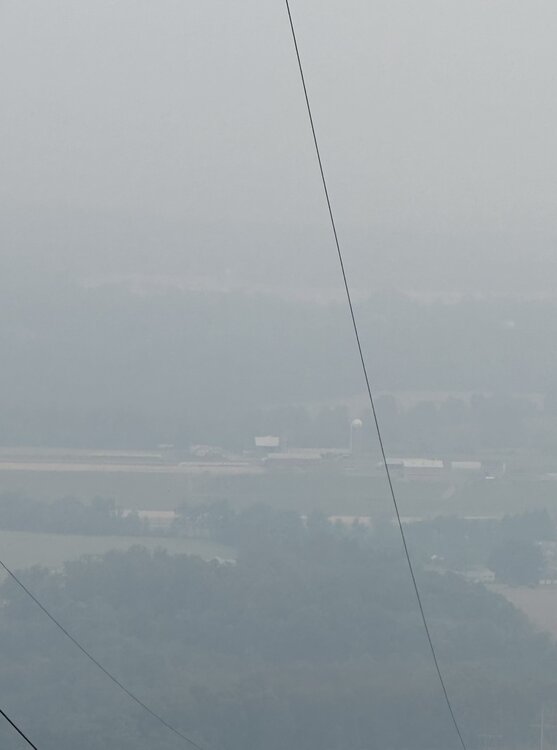
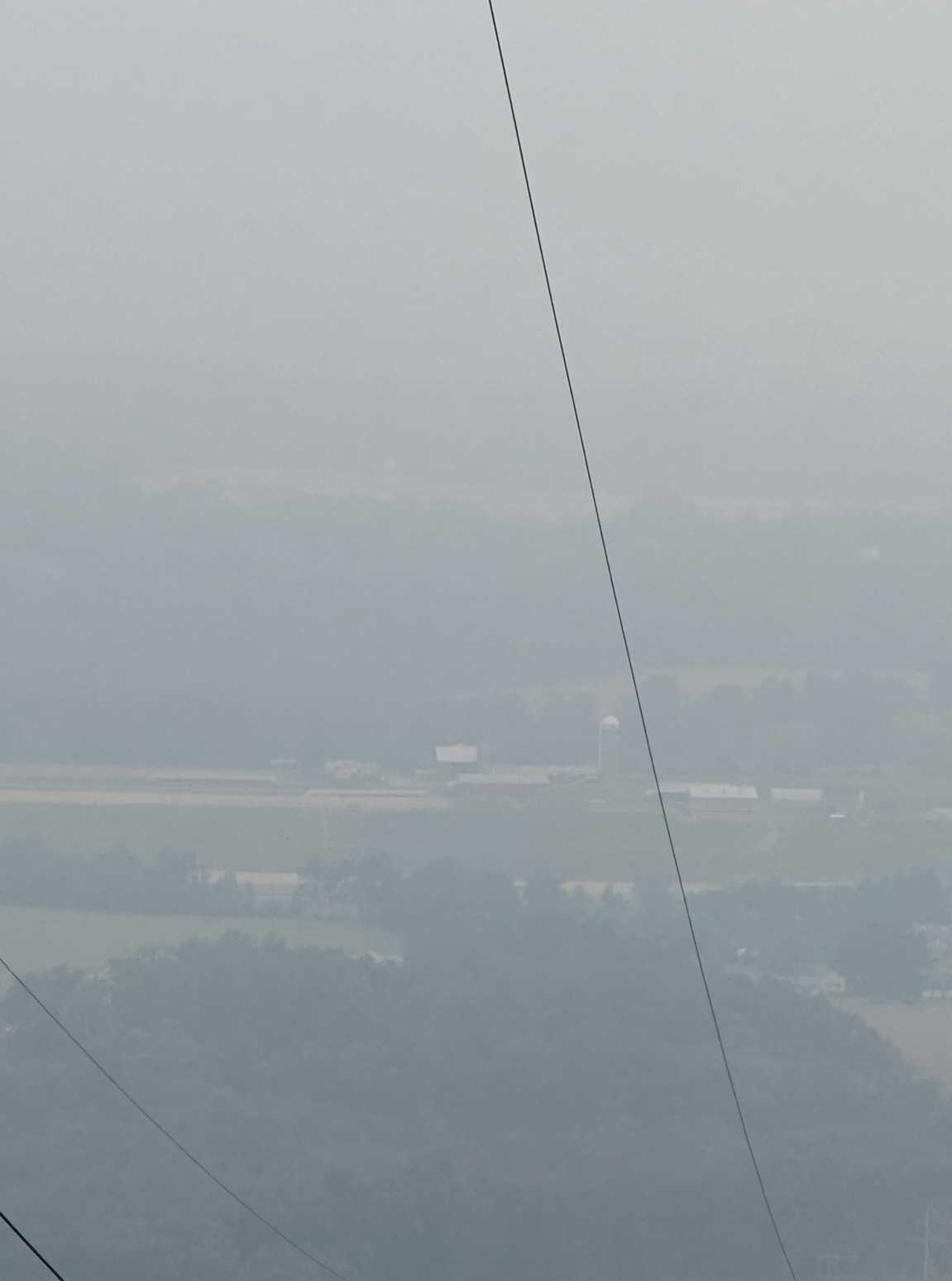
Like everywhere else, Williamsport has gotten better. Right before I went to bed around 5:30a I looked out and I could see the distant hills again which had disappeared and nearer things looked fairly normal. At 5:26 we had PM196 and visibility of 3 miles. Just now at 4:43p we had PM130 and visibility of 7 miles. Yesterday they said things will get worse later this evening. We shall see.
I hope I never look out and see almost everything near and far look different and much covered up by smoke like yesterday. But the way things are going, I probably will.
I think in the future I will think of fog in a different way. It will be a reminder of this week on the one hand but I will be so happy it isn't smoke on the other.
-
8 hours ago, Mount Joy Snowman said:
Good morning all, low of 47 here. Man, is the smoke thick out there right now. It looks like it should ease up a bit throughout the midday before building back in this evening, and then slowly thinning out tomorrow and through the weekend. But who really knows, as this stuff seems tough to predict as far as exact location and timing. Outside chance of some rain showers later today but the better chance for our area is late in the day tomorrow. Confidence building for a more soaking rainfall Monday into Tuesday and then hopefully some more opportunities in the extended period. Let's get this smoke the hell out of here!
I saw NYC Mayor Adams on TV yesterday. He was talking about what people should expect. He mentioned that smoke prediction wasn't very good past 24 hours. I was surprised other people weren't pointing that out. Yesterday was just as bad if not worse for them yet I believe it had been predicted to be better. If smoke predictions aren't great, that would explain that, wouldn't it?
I would be interested in hearing more about this if anybody knows.
-
1
-
-
57 minutes ago, TheDreamTraveler said:
Air quality hit over 207 here now and it keeps getting worse.
So my dad got mulch for his yard and I'm assuming that he's going to be shoveling a huge amount of it later today and I'm wondering if that's not a good idea for him to do given how conditions are right now. I did tell him the other day about the air quality but I don't think neither of us thought it'd get this bad. Do any of you think it's a good idea for him to do that? He's pretty healthy and in great shape but he's in his mid 60's so I'm just a bit worried about him being out there shoveling that for hours. Knowing him he'll probably just do it regardless lol
I walked out to see how bad it got and almost instantly I started coughing. It felt like I took a huge plume of smoke directly into my lungs. It's fucking awful out
The mulch will wait for him. I wouldn't do it today and probably not tomorrow either. I would say this to anyone: Just avoid activity and the air outside right now if you can.
-
1
-
-
4 hours ago, Voyager said:
Thanks for the link. I tried to save my results by downloading it on my phone but the map didn't save. Anyway, Williamsport is a crazy 473 and Bloomsburg is 505 as of 5:42.
-
This is not the rhetorical question that I thought it would be, after tooling around a bit just now looking for more info about this smoke:
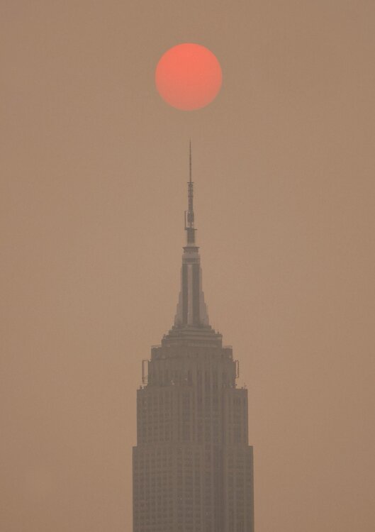
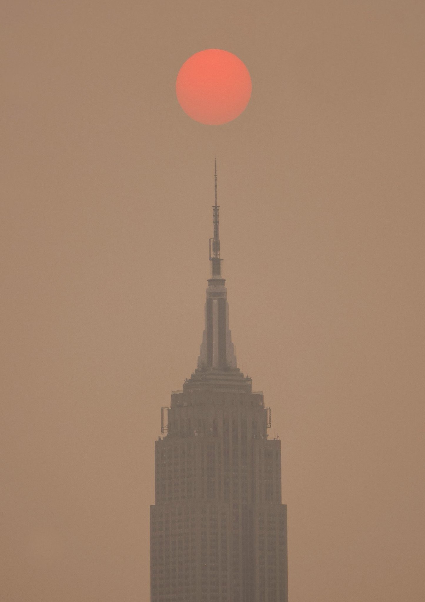
Will anybody here be able to meet or beat the Empire State building on smoke for yesterday, June 6? Now I am also wondering if NYC will beat itself today but we will have to see.
-
6 hours ago, Wmsptwx said:
Thanks for putting the pictures up. I am in Williamsport. As I recall, you are in eastern Lycoming County. I was just curious where these were taken. We care going to be worse tomorrow. Earlier we were 120 something and now we are in Red at 164. Bloomsburg is worse in the 180s for the usual PM2.5 measurement and over 200 for PM10.
Yipes! I went back to Wunderground and saw at 2:03a PM2.5 was 189 at Bloomsburg. At 2:15 it was 5 points higher in less that 15 minutes!
2:15 AM PM2.5 194.48
2:15 AM PM10 208.79-
1
-
-
6 hours ago, TheClimateChanger said:
Unfortunately, the next two days look just as bad as today. Tomorrow looks to be the worst, maybe a slight reprieve on Thursday. Of course, that's contingent on additional fires not breaking out between now and then inserting additional smoke. I don't know what the weather is like in Quebec, presumably dry. But there have been bouts of pyrocumulonimbus in recent days, which can be accompanied by dry lightning.
Near surface smoke at 5 pm on Wednesday:

Near surface smoke at 5 pm on Thursday:

Oh Jesus. Looks like northern 3/4 of our state gets hammered today. I am not sure Williamsport is part of the orange-red bit sticking down from NY state on Thursday but we are too close for comfort for me. Thanks for putting these maps up. I will take out garbage tonight. I wonder how much smoke gets into the house when the windows are shut and door only opened briefly? It will be in 70s/40s next few days so I can keep windows closed. If this keeps happening when we hit humidity plus 80s/60 though, I will have to keep windows open.
For many years I used to live in downtown Jersey City, only separated from the Wall Street area of Manhattan by 10 blocks and the Hudson River. Yesterday's pictures of NYC are wild. They were in purple for bad air, so my old building must have been just as bad. So glad not to have been there.
-
12 minutes ago, Bubbler86 said:
Most farmers can get Fed aid if they substantiate their losses so hopefully that works out for them.
True.
But farming is always a gamble, there is no denying it. Farmers in PA are all small guys and with our weather, they are not used to long periods of semi-drought or other things that happen much more in the Midwest. Plus the price of food has gone up like crazy but as usual, I am sure they got very little of that extra money even as their costs went up.
It isn't just one year. The whole game of farming is getting harder and riskier for them and I am not sure they all will stay in the game. I don't want to see people forced out. Honestly I myself don't want to have the weather that would make them give up.
-
2
-
-
Weather guy on WNEP Channel 16 was just talking about the area's lack of rain. He noted Williamsport's "especially pathetic .44" for May and ended his segment by noting the record breakers (like us) as of today should stay where they are.
There was a news segment about farmers over near Muncy on our county. The strawberry farmer cancelled Pick Your Own Strawberries and hopes to salvage half his crop. A lady farmer said the soil in her fields is like concrete and is getting dusty and blowing around.
I really feel sorry for them, especially since we do not know when things will go back to normal long term. I realized in December we were no longer having lots more sunny days than normal but of course now we are again.
-
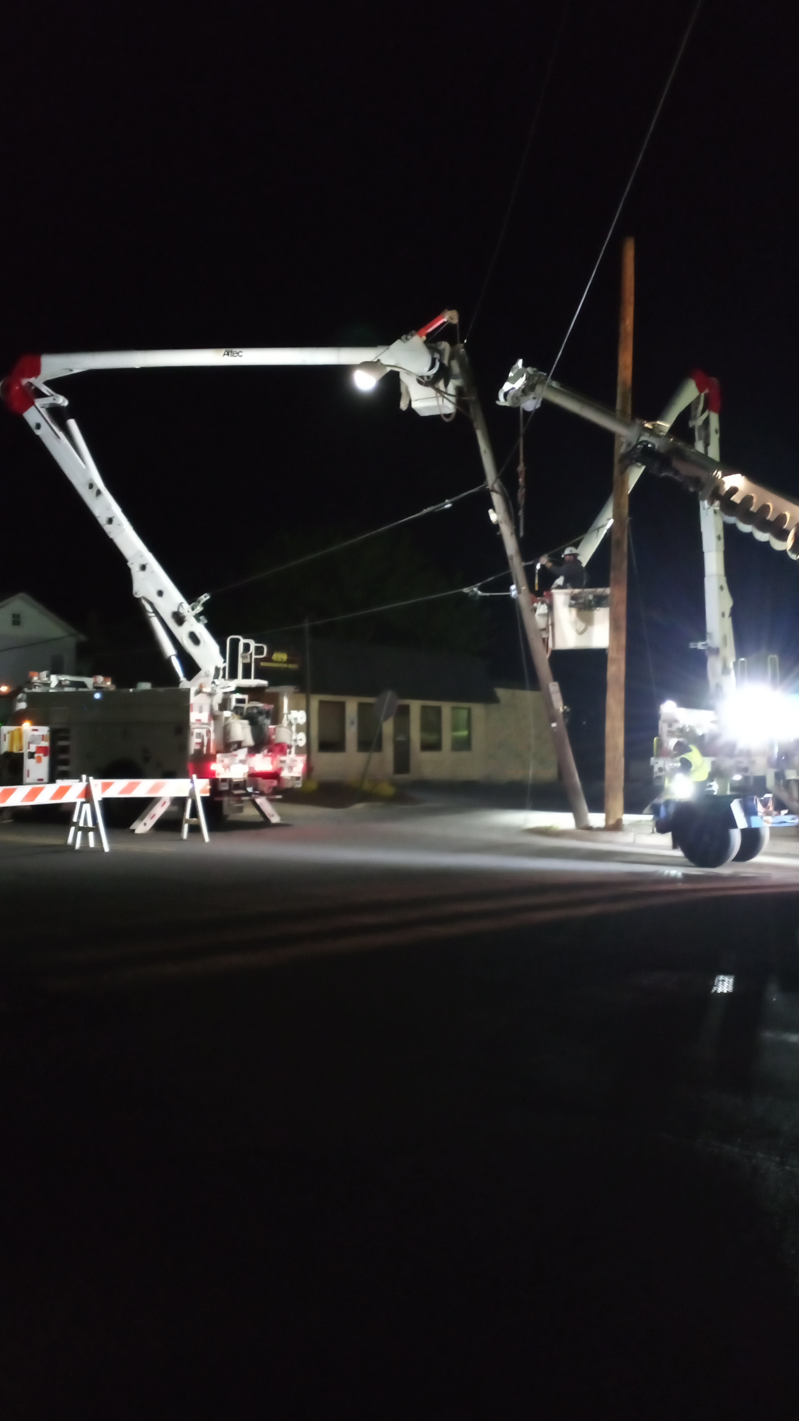
2:35a: It is 37 in Williamsport and not looking good to meet or beat our record of 31. In other news right now -- yes, there is some other news at this hour-- crews are out replacing four light poles that got pulled and twisted and are now leaning into street while building slowly being taken apart at the corner. Crews not only unlucky to still be out this late but it is cold out there, of course. People coming later to redo damaged concrete sidewalks will have a much easier job. I am sure glad I don't have to get up early tomorrow; my sleep would have been interrupted. Actually it is surprising it is not a lot noiser out there. I didn't hear any jackhammering.

-
3
-
-
We reached 61 in Williamsport today and are now 47.
Our Area Forecast Discussion says: "Right now, we [sic] bottom readings out in the low-mid 20s for our far northern counties, but some lows near, or even a shade below 20, would not be unrealistic."
So we may have places in PA that may get into the teens. I thought meeting or beating our record of 31 would be impressive. Teens would be amazing.
-
Here is a later Freeze Warning from the one above with extra counties. Williamsport-Southern Lycoming was added:
FREEZE WARNING
ISSUED: 6:32 PM MAY. 17, 2023 – NATIONAL WEATHER SERVICE
...FREEZE WARNING REMAINS IN EFFECT FROM MIDNIGHT TONIGHT TO 8 AM EDT THURSDAY...* WHAT...Sub-freezing temperatures as low as 31 expected.
* WHERE...Clearfield, Northern Centre, Southern Centre, Southern
Clinton, Southern Lycoming, Union, Snyder, Montour,
Northumberland and Columbia Counties.* WHEN...From midnight tonight to 8 AM EDT Thursday.
* IMPACTS...Frost and freeze conditions will kill crops, other
sensitive vegetation.-
 1
1
-
-
8 hours ago, Voyager said:
Gotta love the flame graphics on this pic from Facebook...lol

At what point is a devil with a pitchfork running around included in the graphics? I was going to say 110 but on second thought, isn't 110 pretty common? I hope we will stay comfy here for a few more weeks before the heat and humidity kick in and stay on for the next three months or more.
-
I thought people might be interested in this Texas weather story in which Penn State meteorologists play a role.
I have followed this Traces of Texas old photos Twitter site for a few months. It is consistently interesting and tells me all kinds of things about America's past I did not know or appreciate like I should. I wish there was something like it for Pennsylvania.
https://twitter.com/TracesofTexas/status/1649102190454226964?s=20
-
2
-
Central PA Summer 2023
in Upstate New York/Pennsylvania
Posted
Just checked and Williamsport vicinity is definitely willing the booby prize for bad air in PA. At 11:22p we were 259-268-274. Milton is 196, Bloomsberg area is 129-132-141. That was a real surge. Earlier tonight it was just over 150. As I recall, earlier this month we just had 2 Purple Air machines reporting, Milton had none and Bloomsberg had 2. So the bad air is helping Purple Air's business.
I am so glad someone here passed on the link for them and Pivotal for the smoky air prediction map. It was cool enough for me to close all windows a little while ago, thank goodness.