

CoralRed
-
Posts
337 -
Joined
-
Last visited
Content Type
Profiles
Blogs
Forums
American Weather
Media Demo
Store
Gallery
Posts posted by CoralRed
-
-
It is 73 here in Williamsport. We got to 78 today and it was humid here too, which I was not expecting. Our overnight low was 59. The average for 10/15/21 is 63/43 and the record is 82/28.
We were supposed to be cloudy and rainy this afternoon but luckily the skies stayed partially blue and the rain never came. Not a bad closing for the bonus two extra weeks of summer we have had all month.
-
 1
1
-
-
I am sitting here quite comfy at 3:25am. The average high for October 13 in Williamsport happens to be the current temperature, which is 63. The average low is 42. Later today we are supposed to hit 73.
This month so far has been heavenly for this time of year. I have yet to go out in the afternoon in long sleeves, much less a sweater. One night I went to the store around 9:00 and put a sweater on. That's it. I am not ready for the change over on Saturday and I am not ready to give up daylight savings time in a few weeks, either.
I will always think of the summer of 2020 as the summer of blue skies -- with the drought we had a lot fewer cloudy days. Looks like 2021 will be the summer that didn't want to leave.
-
1
-
-
We have watches and warnings and special statements for Williamsport and the rain total was increased to 2.31. The radar still doesn't look that bad but the ones getting it are keeping it. Some quiet thunder, the sky is not completely dark.
-
We are supposed to get a surprise soaking here in Williamsport. Late overnight the rain for today was supposed to be around .25, I think. Now it is supposed to be 1.77, mostly between 4-6p. I figured there would be a wall of color coming our way on radar but that isn't true. I am staying home from the library so we better get something too big for umbrellas to handle!
-
We are about to get hit here in Williamsport. We have had a bit of rain and some lightening and thunder. The radar map shows the green that we have been under will be replaced by red, orange and yellow coming down from the north. Wunderground keeps changing the amounts. It had us at I think .13 rain tonight around 6:30p; 20 minutes ago it was 1.23; now it is calling for .51 of rain. We will see.
-
25 minutes ago, Tezeta said:
I was just asking questions because I am very worried and concerned. To ask how prepared you are is not being snippy. To say that people who cannot evacuate are sitting ducks is simply being truthful, it is not saying anything bad.
There are many millions of people around America tonight wondering about the same things I am and it is because they are your fellow Americans who love you. If you find that laughable, stupid or annoying, I don't know what to tell you.
-
So how prepared are the people down there in Louisiana to take this hit? My recollection is the levies were rebuilt/modified for a CAT 3 storm and of course this is supposed to be CAT 4. How much wind, water and surge are they prepared for vs. what is coming?
I was thinking of Katrina and now an Afghanistan comparison comes mind and that isn't crazy either, God help us. Are we going to see a Hurricane Ida version of Afghanistan's instant collapse down there?
I can't believe they are almost all going to be sitting ducks.
-
 2
2
-
-
We had heavy rain for at least half an hour awhile ago here in Williamsport. Now it is is a steady moderate rain. We were not supposed to get anything from Henri but almost of Lycoming County is getting rain right now and the eastern half of Clinton County to our west is too.
-
Wow! You all had all kinds of things going on.
Here in very quiet Williamsport we had less than 1.5" of rain and the rain is almost over. What we didn't have was thunder, lightening or winds to speak of.
The excitement will have to come another day; it missed us tonight.
-
I went to see the Area Forecast Discussion to see what else I could find out about upcoming heat. I must give the NWS credit for telling me exactly what I wanted to know in their 1:21am update:
LONG TERM /FRIDAY NIGHT THROUGH WEDNESDAY/...
The extended period will be marked by a trend toward a sultry
summer sizzle with hot temperatures and dewpoints in the upper
60s and low 70s. Increased heat and humidity will prompt the
chance of afternoon showers and thunderstorms, but there is no
apparent heavy rain threat at this time.
Sultry summer sizzle. OK. Not what I want but now I know what's coming. I have been happy to keep the windows closed and wear my bathrobe late at night with temps in the 50s but it's coming to an end. I am surprised it lasted as long as it did here in Williamsport at this time of year.
-
On 8/3/2021 at 3:20 PM, canderson said:
I noticed last night it has started getting darker earlier. Mid August to mid September it moves so quickly.
Oh no!
I have been noticing the difference from late June for several weeks now. I am really missing looking out the windows at 9:20 and realizing it's still not 100% dark outside; almost but not quite.
I do not normally miss peak summer light but I am this year. So the darker days ahead will be hard. I have been telling myself to pay more attention in the future and try to enjoy the latest light even more next summer.
-
1
-
-
The darkness and increased winds have arrived but Williamsport is not part of the 4:14pm Special Weather Statement issued for nearby places due to thunderstorms. Now I hear the thunder. Let us see what we get.
4:57 Update. Now we are included. So far we have gotten thunder without lightening and the rain is not as bad as I thought it might be.
ISSUED: 4:52 PM AUG. 1, 2021 – NATIONAL WEATHER SERVICE...STRONG THUNDERSTORMS WILL AFFECT PARTS OF SOUTHERN LYCOMING... SOUTHERN CLINTON...UNION...NORTHUMBERLAND...MONTOUR...JUNIATA... HUNTINGDON...MIFFLIN...SNYDER...AND SOUTHERN CENTRE COUNTIES UNTIL 530 PM EDT... At 450 PM EDT, Doppler radar indicated strong thunderstorms along a line extending from near Petersburg to Williamsport moving east southeast at 40 mph.
5:20 By the way, from our Area Forecast Discussion:
CLIMATE...
July 2021 ranked as the 10th wettest at Williamsport (4.64"|
+2.35") 9th wettest at Harrisburg (8.00"|+3.26") and 3rd
wettest at Bradford (4.16"|+2.59"). -
All kinds of stuff going on in Williamsport and Lycoming County the last half hour. We currently have seven weather alerts up.
I went upstairs to shut windows when things really got going shortly before 5:30 and had to push very hard to open my bedroom door against the wind. From my brother's bedroom I looked out over the empty parking lot at the wind driven rain travelling in vertical waves and then realized I couldn't see clearly anymore. Things were darker and blurry for about a minute. I realized that what was outside looked like fog. Then things looked lighter and I could see normally again; it was quite the contrast to the minute of rain fog.
If I have ever seen rain like before, I do not remember. The rain fog was around 5:32. I wrote it down so I can remember.
-
1
-
-
Williamsport has a Flash Flood Watch for tonight through tomorrow evening.
* Flash Flood Watch for a portion of central Pennsylvania, including
the following areas, Cameron, Elk, McKean, Northern Clinton,
Northern Lycoming, Potter, Southern Clinton, Southern Lycoming,
Sullivan, Tioga and Warren.

* From 10 PM EDT this evening through Saturday evening.

* A slow moving front will focus rounds of locally heavy rainfall
across the Watch area tonight and Saturday. Extremely wet soils
will lead to rapid runoff and possible flash flooding in areas of
heavy rain.
We are supposed to get about 1.25" of rain between now and tomorrow night. I hope we don't get much more than that but who knows what the thunderstorms will bring?
-
7:25p in Williamsport: the sun is shining brightly and there are blue skies to my west. The big black cloud above is headed east and I can hear the light rain falling outside from my couch. Still hearing faint thunder.
No show tonight, obviously. Lazy me didn't reshut the windows so I now I don't have to reopen them.
-
Special Weather Statement for this surprise thunderstorm. Pea-sized hail and winds of 50-55. We didn't get those when predicted last night and I hope we don't tonight, either. Almost looks like it could miss us but it's moving southeast so I guess it won't. Faint thunder is here.
-
Surprise! Not over quite yet for Williamsport. Our radar is clear but we were getting a few lightening bolts spreading across the sky. Now I just heard a bit of thunder, I think.
We have a flood advisory, watch and warning. I hope people aren't having big problems.
-
10:08pm Radar looks about the same for us as far as I can tell. I was out on the porch for at least five minutes watching the sky light up but no lightening bolts. Now while typing this I heard a crash. So will we have a full show? We will see. Very loud thunder now. Wind is not bad though. I hope we don't lose the electricity.
By the way. Godfather II has been on. This storm ruined watching it sort of but provided some great music at times.
-
1
-
-
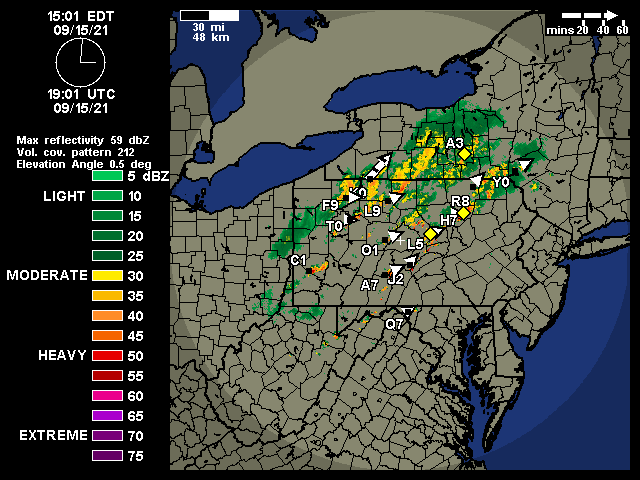
We finally got something worth talking about here in Williamsport. Both yesterday and today there were points where 2-3 inches would be predicted but the amount would go down, down, down. Before the storm came through at last Wunderground had us down for 0.14.
We did a little better than that, needless to say.
Just a minute ago we got a tornado warning cancelled. That's probably the fifth or sixth notice we've had tonight.
Update: Another "strong thunderstorm" coming our way by 9:45pm according to special weather statement, with torrential rain and pea sized hail.
Update 2: Another severe thunderstorm warning for us from 9:30-10:30pm. Is this the same one from the special weather statement or a new one? I don't know. It does not mention torrential rain or hail and includes more places.
-
2
-
-
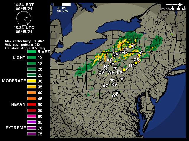
1 hour ago, Anduril said:
Looks like the worst of it went South of you guys Milton / Lewisburg def took some strong winds
I guess it did.
We never got a big show. Rain and thunder and lightening that never got louder than the TV, that was it. Believe it or not, winds never got above 8 miles an hour at Montoursville Airport five miles away! See for yourself. I can't really understand it myself.
https://www.wunderground.com/history/daily/us/pa/montoursville/KIPT/date/2021-7-11
-
2 minutes ago, Anduril said:
Pretty sure Williamsport was included in the Tornado warning for the cell that possibly affected Lock Haven...
It certainly was. That ended at 8:15. The 8:03 Severe Thunderstorm Warning didn't include us, though.
Southeastern Lycoming County in north central Pennsylvania...
Columbia County in central Pennsylvania...
-
Still waiting here in Williamsport for the big event. Our dot has remained in mostly green on the radar but that will be changing soon at last. We were not even mentioned in the most recent severe thunderstorm warning, only Muncy and Hughesville to our east in Lycoming County.
-
11 minutes ago, Anduril said:
Same returns that were showing possible tornado for Blanchard/Beech Creek area _def_ seemed to go through Lock Haven area. Hope people are ok
I hope we will be fine. The tornado warning say we'll be getting it here in Williamsport at 8:10. TV just said winds are around 50 mph so I am going to shut the windows now.
-
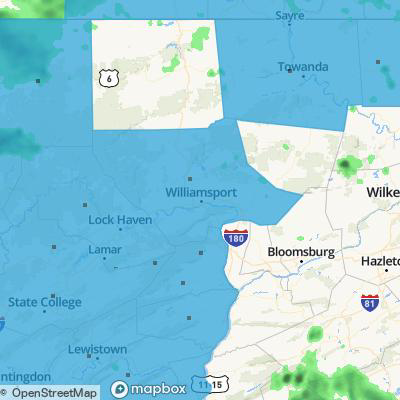
There is something special about Tioga county. I wonder why they got left out our Severe Thunderstorm Watch?
Central PA - Fall 2021
in Upstate New York/Pennsylvania
Posted
That's too bad. I wish more younger people would post. And more people in the northern part of our area would be good, too. Right now when I pop in a couple times a week at least, I am the only one from Lycoming County and no one else is near me at all.