

CoralRed
-
Posts
320 -
Joined
-
Last visited
Content Type
Profiles
Blogs
Forums
American Weather
Media Demo
Store
Gallery
Posts posted by CoralRed
-
-
8 hours ago, Mount Joy Snowman said:
Good morning all, low of 47 here. Man, is the smoke thick out there right now. It looks like it should ease up a bit throughout the midday before building back in this evening, and then slowly thinning out tomorrow and through the weekend. But who really knows, as this stuff seems tough to predict as far as exact location and timing. Outside chance of some rain showers later today but the better chance for our area is late in the day tomorrow. Confidence building for a more soaking rainfall Monday into Tuesday and then hopefully some more opportunities in the extended period. Let's get this smoke the hell out of here!
I saw NYC Mayor Adams on TV yesterday. He was talking about what people should expect. He mentioned that smoke prediction wasn't very good past 24 hours. I was surprised other people weren't pointing that out. Yesterday was just as bad if not worse for them yet I believe it had been predicted to be better. If smoke predictions aren't great, that would explain that, wouldn't it?
I would be interested in hearing more about this if anybody knows.
-
 1
1
-
-
57 minutes ago, TheDreamTraveler said:
Air quality hit over 207 here now and it keeps getting worse.
So my dad got mulch for his yard and I'm assuming that he's going to be shoveling a huge amount of it later today and I'm wondering if that's not a good idea for him to do given how conditions are right now. I did tell him the other day about the air quality but I don't think neither of us thought it'd get this bad. Do any of you think it's a good idea for him to do that? He's pretty healthy and in great shape but he's in his mid 60's so I'm just a bit worried about him being out there shoveling that for hours. Knowing him he'll probably just do it regardless lol
I walked out to see how bad it got and almost instantly I started coughing. It felt like I took a huge plume of smoke directly into my lungs. It's fucking awful out
The mulch will wait for him. I wouldn't do it today and probably not tomorrow either. I would say this to anyone: Just avoid activity and the air outside right now if you can.
-
1
-
-
4 hours ago, Voyager said:
Thanks for the link. I tried to save my results by downloading it on my phone but the map didn't save. Anyway, Williamsport is a crazy 473 and Bloomsburg is 505 as of 5:42.
-
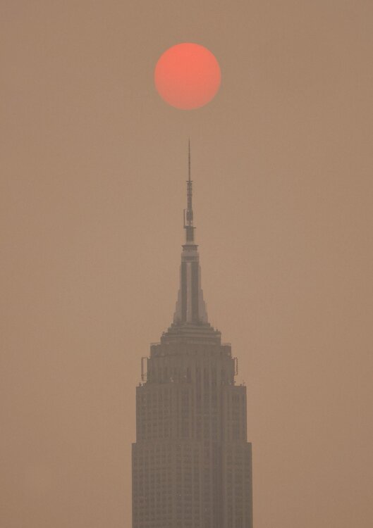
This is not the rhetorical question that I thought it would be, after tooling around a bit just now looking for more info about this smoke:
Will anybody here be able to meet or beat the Empire State building on smoke for yesterday, June 6? Now I am also wondering if NYC will beat itself today but we will have to see.
-
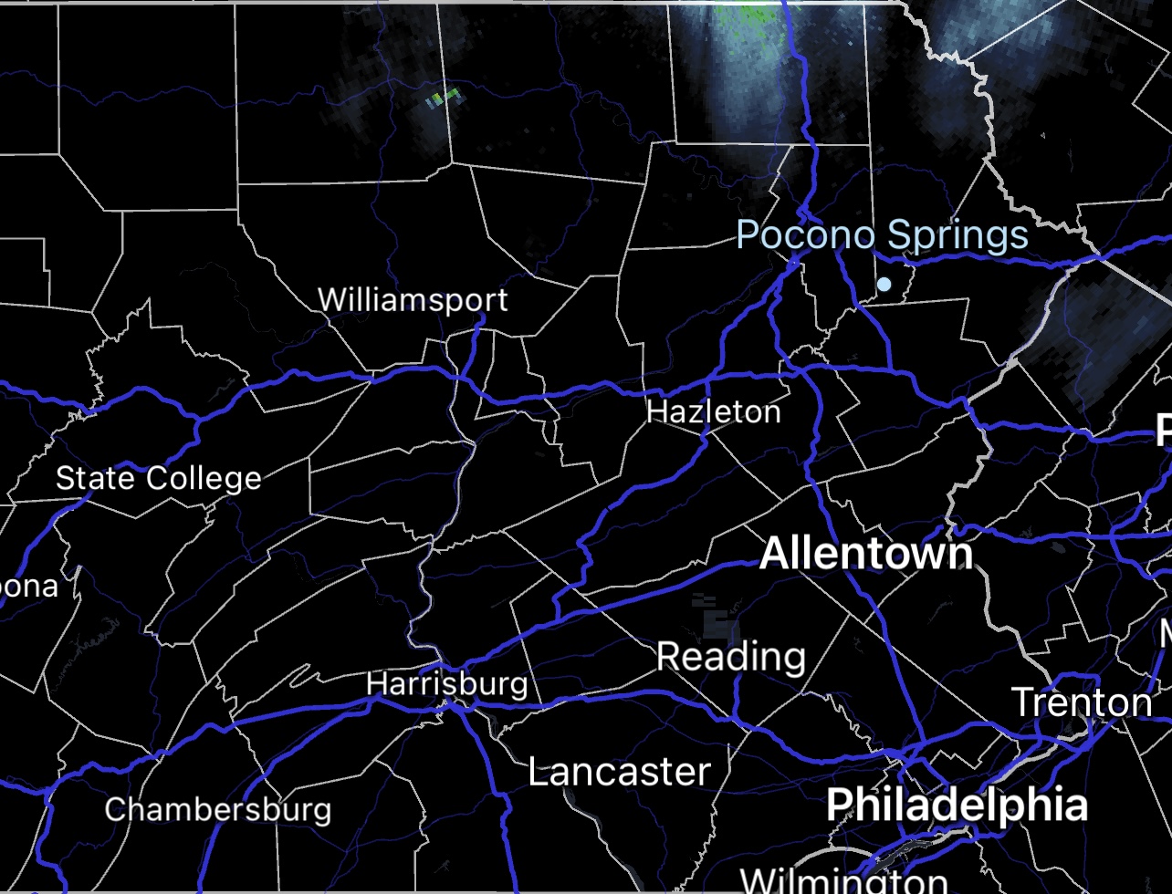
6 hours ago, Wmsptwx said:
Thanks for putting the pictures up. I am in Williamsport. As I recall, you are in eastern Lycoming County. I was just curious where these were taken. We care going to be worse tomorrow. Earlier we were 120 something and now we are in Red at 164. Bloomsburg is worse in the 180s for the usual PM2.5 measurement and over 200 for PM10.
Yipes! I went back to Wunderground and saw at 2:03a PM2.5 was 189 at Bloomsburg. At 2:15 it was 5 points higher in less that 15 minutes!
2:15 AM PM2.5 194.48
2:15 AM PM10 208.79-
1
-
-
6 hours ago, TheClimateChanger said:
Unfortunately, the next two days look just as bad as today. Tomorrow looks to be the worst, maybe a slight reprieve on Thursday. Of course, that's contingent on additional fires not breaking out between now and then inserting additional smoke. I don't know what the weather is like in Quebec, presumably dry. But there have been bouts of pyrocumulonimbus in recent days, which can be accompanied by dry lightning.
Near surface smoke at 5 pm on Wednesday:

Near surface smoke at 5 pm on Thursday:

Oh Jesus. Looks like northern 3/4 of our state gets hammered today. I am not sure Williamsport is part of the orange-red bit sticking down from NY state on Thursday but we are too close for comfort for me. Thanks for putting these maps up. I will take out garbage tonight. I wonder how much smoke gets into the house when the windows are shut and door only opened briefly? It will be in 70s/40s next few days so I can keep windows closed. If this keeps happening when we hit humidity plus 80s/60 though, I will have to keep windows open.
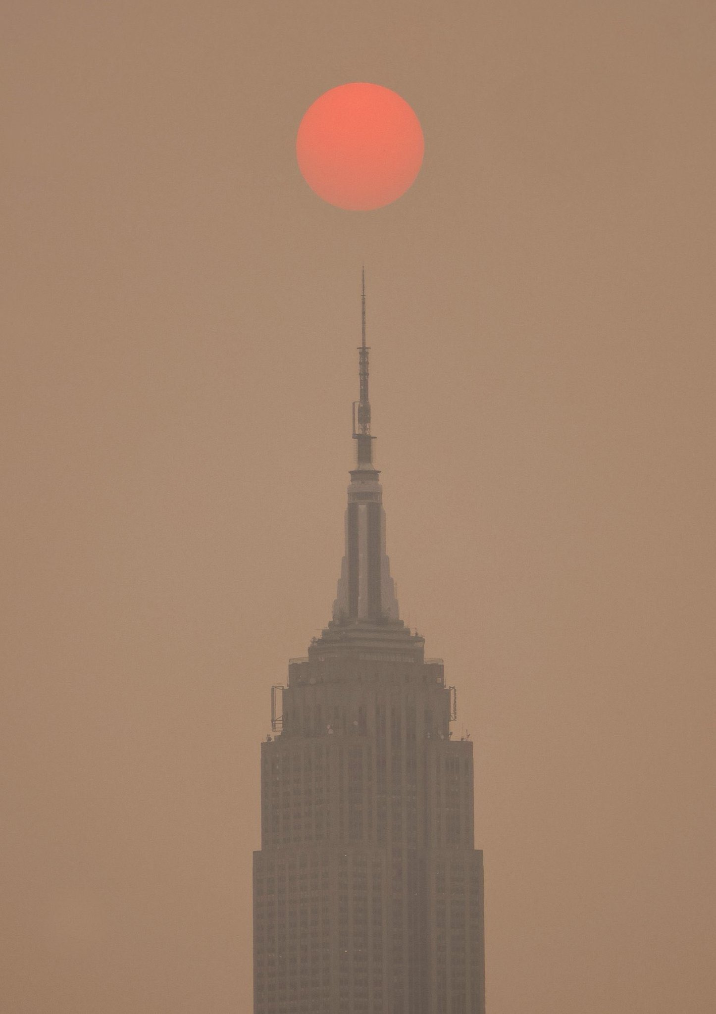
For many years I used to live in downtown Jersey City, only separated from the Wall Street area of Manhattan by 10 blocks and the Hudson River. Yesterday's pictures of NYC are wild. They were in purple for bad air, so my old building must have been just as bad. So glad not to have been there.
-
12 minutes ago, Bubbler86 said:
Most farmers can get Fed aid if they substantiate their losses so hopefully that works out for them.
True.
But farming is always a gamble, there is no denying it. Farmers in PA are all small guys and with our weather, they are not used to long periods of semi-drought or other things that happen much more in the Midwest. Plus the price of food has gone up like crazy but as usual, I am sure they got very little of that extra money even as their costs went up.
It isn't just one year. The whole game of farming is getting harder and riskier for them and I am not sure they all will stay in the game. I don't want to see people forced out. Honestly I myself don't want to have the weather that would make them give up.
-
2
-
-
Weather guy on WNEP Channel 16 was just talking about the area's lack of rain. He noted Williamsport's "especially pathetic .44" for May and ended his segment by noting the record breakers (like us) as of today should stay where they are.
There was a news segment about farmers over near Muncy on our county. The strawberry farmer cancelled Pick Your Own Strawberries and hopes to salvage half his crop. A lady farmer said the soil in her fields is like concrete and is getting dusty and blowing around.
I really feel sorry for them, especially since we do not know when things will go back to normal long term. I realized in December we were no longer having lots more sunny days than normal but of course now we are again.
-
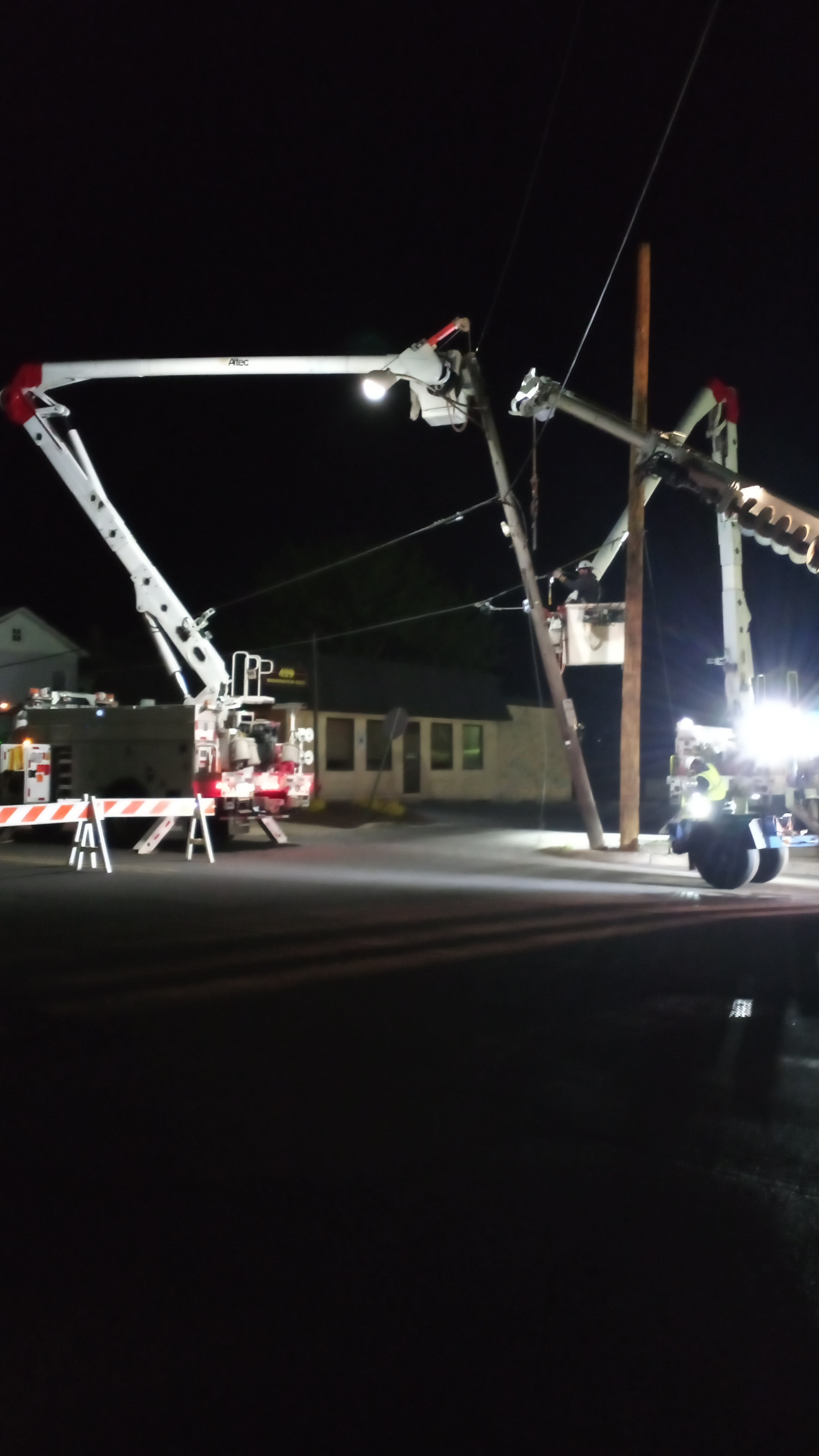
2:35a: It is 37 in Williamsport and not looking good to meet or beat our record of 31. In other news right now -- yes, there is some other news at this hour-- crews are out replacing four light poles that got pulled and twisted and are now leaning into street while building slowly being taken apart at the corner. Crews not only unlucky to still be out this late but it is cold out there, of course. People coming later to redo damaged concrete sidewalks will have a much easier job. I am sure glad I don't have to get up early tomorrow; my sleep would have been interrupted. Actually it is surprising it is not a lot noiser out there. I didn't hear any jackhammering.

-
3
-
-
We reached 61 in Williamsport today and are now 47.
Our Area Forecast Discussion says: "Right now, we [sic] bottom readings out in the low-mid 20s for our far northern counties, but some lows near, or even a shade below 20, would not be unrealistic."
So we may have places in PA that may get into the teens. I thought meeting or beating our record of 31 would be impressive. Teens would be amazing.
-
Here is a later Freeze Warning from the one above with extra counties. Williamsport-Southern Lycoming was added:
FREEZE WARNING
ISSUED: 6:32 PM MAY. 17, 2023 – NATIONAL WEATHER SERVICE
...FREEZE WARNING REMAINS IN EFFECT FROM MIDNIGHT TONIGHT TO 8 AM EDT THURSDAY...* WHAT...Sub-freezing temperatures as low as 31 expected.
* WHERE...Clearfield, Northern Centre, Southern Centre, Southern
Clinton, Southern Lycoming, Union, Snyder, Montour,
Northumberland and Columbia Counties.* WHEN...From midnight tonight to 8 AM EDT Thursday.
* IMPACTS...Frost and freeze conditions will kill crops, other
sensitive vegetation.-
 1
1
-
-
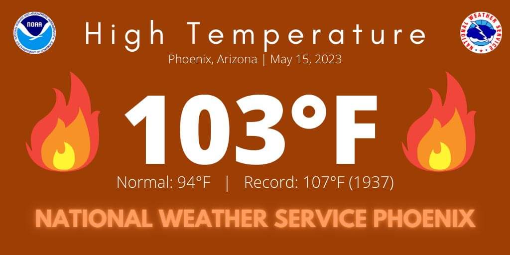
8 hours ago, Voyager said:
Gotta love the flame graphics on this pic from Facebook...lol

At what point is a devil with a pitchfork running around included in the graphics? I was going to say 110 but on second thought, isn't 110 pretty common? I hope we will stay comfy here for a few more weeks before the heat and humidity kick in and stay on for the next three months or more.
-
I thought people might be interested in this Texas weather story in which Penn State meteorologists play a role.
I have followed this Traces of Texas old photos Twitter site for a few months. It is consistently interesting and tells me all kinds of things about America's past I did not know or appreciate like I should. I wish there was something like it for Pennsylvania.
https://twitter.com/TracesofTexas/status/1649102190454226964?s=20
-
2
-
-
High of just 48 today here in Williamsport so the winter coat will come out of the closet again. Now I see this too:
Cloudy with snow showers mainly during the morning. High 48F. Winds W at 10 to 20 mph. Chance of snow 60%
Will we really get any snow? I am not counting on it. High of 65 on Wednesday, then 82 on Thursday.
-
7 hours ago, ChescoWx said:
I noticed that our local channel 6 weather team over in Philadelphia has been posting how since 1970 springs are getting warmer....as is always the case they only seem to look at since 1970. Why is that a problem? A quick look (see below) at the 3 major NWS COOP sites here in Chester County PA show that by starting the analysis in 1970 the data is clearly skewed because overall the 1960's was the decade with the coolest readings. The warmest springs here in Chester County averaged over the 3 long term sites actually occurred back in the 1940's. Only focusing on 50 years does not prove a trend.

Interesting. I wonder if they are using since 1970 because 50 years seems like enough or it is just convenient -- or because of climate change? I sure do not know but what do we make of weather history when we ourselves have apparently changed the weather overall but cannot point to individual events as definitely caused by climate change?
-
1
-
-
1 hour ago, TheDreamTraveler said:
Yeah as soon as its approaching me it breaks up in the middle exactly where I am. rip lmao

What a joke of a night, right? We had a third thunderstorms weather statement at 11:15 but still no show and hardly any rain. I suppose we will remember this time of constant disappointment someday when we are getting rain or snow all the time.
-
1
-
-
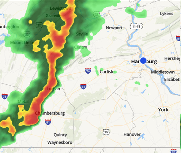
First round was a dud. One flash of light, no thunder. But wait! The weather gods who teased us so often this year are giving me a second chance to be left down:
SPECIAL WEATHER STATEMENT
ISSUED: 10:26 PM APR. 5, 2023 – NATIONAL WEATHER SERVICE
...A STRONG THUNDERSTORM WILL IMPACT CENTRAL LYCOMING AND
NORTHWESTERN SULLIVAN COUNTIES THROUGH 1100 PM EDT...At 1023 PM EDT, Doppler radar was tracking a strong thunderstorm over
Williamsport, moving northeast at 70 mph.HAZARD...Wind gusts of 50 to 55 mph and pea size hail.
-
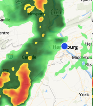
It has been a long time since we had a Special Weather Statement here in Williamsport for a thunderstorm. Let's see if we have some weather excitement worth reporting on later.
ISSUED: 9:57 PM APR. 5, 2023 – NATIONAL WEATHER SERVICE...A STRONG THUNDERSTORM WILL IMPACT CENTRAL CENTRE... SOUTHWESTERN LYCOMING AND SOUTHEASTERN CLINTON COUNTIES THROUGH 1030 PM EDT... At 956 PM EDT, Doppler radar was tracking a strong thunderstorm near Lock Haven, moving northeast at 60 mph. HAZARD...Wind gusts of 50 to 55 mph and pea size hail. SOURCE...Radar indicated. IMPACT...Gusty winds could knock down tree limbs and blow around unsecured objects. Minor hail damage to vegetation possible.
-
Things kicking up in Williamsport. 8:54 update said
Wind Speed NW 36 G 48 mph Out of the blue around 8:45 I heard the wind blowing hard, rain hitting windows and the windows singing their high wind song in the dining room. Then the ones in the living room joined in, at a higher pitch! I am not sure I have ever heard a peep from living room replacement windows before. Brief and eerie. Things quieted down quick but that may not be it for the night.
We also have this Special Weather statement for snow squalls and cold front passing but it mentions places like Canton and Shunk which are not near here and nothing that is.
-
2
-
-
2 hours ago, yard-stick said:
Just coming back into the area from my Miami home today...@ 2000 ft elevation near Luzerne/Schuylkill border...wow! It sure looks like its been a pathetic winter season. Hopefully, we can can get one last snowstorm before we move on to 23-24 season. Accord to my neighbor we've only had around 30" so far...pathetic!!!
Pathetic ends up being in the eye of the beholder.
Over here in Williamsport we had a pretty bad year for snow for sure but I wouldn't say pathetic. What was pathetic was to see big amounts in models decrease to almost nothing or actually nothing time after time.
I think our many posters in the Southern part of PA would say pathetic and even worse about the little snow they got and by the persistent fantasy models that stubbornly continued to show so much more than they got, even the day before the nonevent.
If you like wind though, PA has been the place and will be again tonight and tomorrow, at least up by me. Tree and mold pollen has been high too.
-
1
-
-
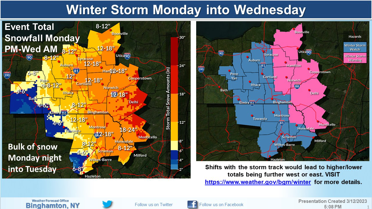
On 3/14/2023 at 10:50 PM, NepaJames8602 said:
Thank you! I’m actually a long term lurker of this regional forum, however I typically post in the Nyc Interior thread given my proximity to that location. I’ll try to drop in here more often. I’m Located in Newfoundland, Pa in Wayne county. The Pocono Springs pin, is my actual location in the Poconos. Roughly 30 min due north of Mt. Pocono. And today was this winters largest snowfall for me. All in all, absolutely pathetic season for everyone. This storm has put me at around 43” inches for the season, so I’ve made up some ground the past two weeks. But it’s still far behind the typical average snowfall for the higher elevations of the Poconos, which range from 60” to 70” inches a season here once you’re at and above 2,000’ feet.

Well I sure hope you keep stopping by. You will be telling us things that nobody else will from your mountain perch in NEPA. When I lived in Jersey City I would post in the NYC forum occasionally and here too when I visited. I have been back in Williamsport permanently for a number of years now and wish we had at least a few more people closer to me. But it is all good; the more, the merrier wherever they come from.
-
1
-
-
38 minutes ago, NepaJames8602 said:
Yup, had a solid 9” to 10” inches here at my location on the northwestern edge of the Pocono Plateau. I measured around 7pm, I’m just shy of 2,100’ feet. Still have bouts of light to moderate snow ongoing as well. So another quick inch or two is still possible to reach a foot in areas. However, this event was highly elevation dependent up this way. My buddy in Scranton barely had 3.0” inches. I took a drive 7 miles from my house down at 1300’ feet, and they had 4” or 5” inches tops.
Good to see someone else from northern PA here. There's me in Williamsport & another person from Lycoming County and that is about it I think. So tonight was your night over there. Good for you, something more than a few inches at last.
-
2
-
-
Well it looks like the people in NEPA will be getting snow worth talking about. My local TV stations here in Williamsport are all located in Scranton/Wilkes-Barre so I will be hearing all about it. I hope this verifies at least somewhat. I don't think anybody in PA will have another chance for double digit snow totals this winter, or probably even half of that. I am so sick of everything going down down down to nothing or the next thing to it.

-
On 3/6/2023 at 9:31 AM, TheClimateChanger said:
Here is the full station history for Pittsburgh as given in the 1978 annual weather summary for the city office.
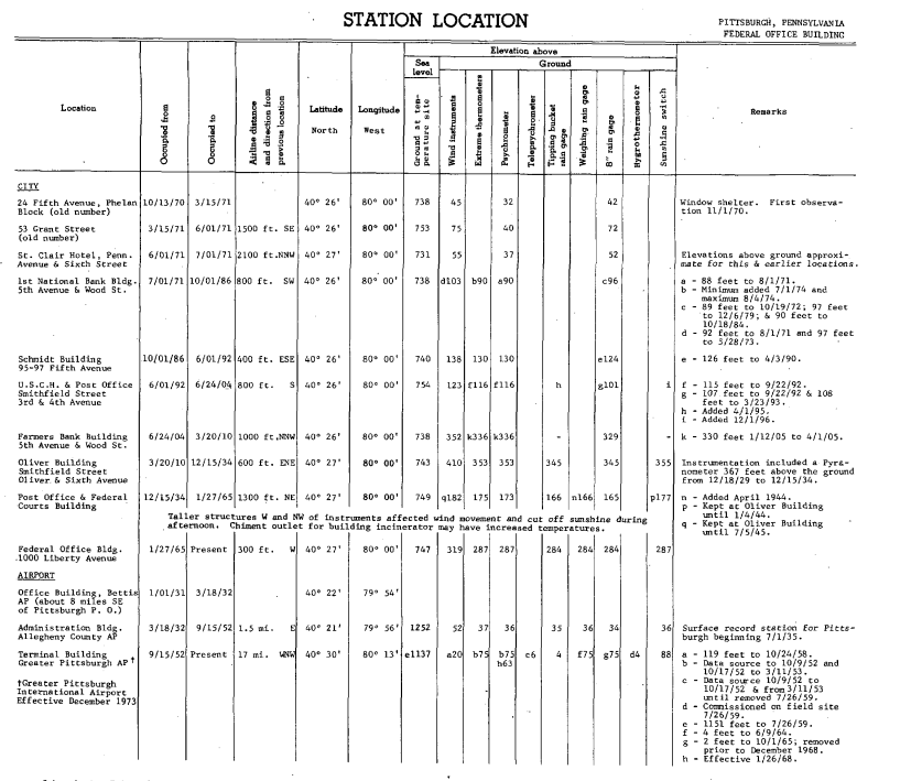
We can see records were taken at various sites downtown until July 1, 1935, at elevations between 731 and 754 feet ASL. The thermometer was sheltered in a windowsill for 1870 and 1871, and then moved to various rooftops at elevations estimated to be between 90 and 353 feet above ground level. In July 1, 1935, the station moved to the Administration Building at AGC, with an elevation of 1,252 feet ASL. The thermometer continued to be mounted on the rooftop at 37 feet above ground level. On September 15, 1952, the station moved to the Terminal Building at PIT, with an elevation of 1,137 feet ASL. The thermometer continued to be located on a rooftop about 75 feet above ground level through at least 1979. Not sure when it was moved to the standard 2 meters above the surface. Rooftop measurements can have a significant warm bias but the first 110 years were exclusively rooftop measurements, well except for the first couple years of a thermometer in a window.
This is our "official" temperature thread.
I hit this Pittsburgh forum by mistake instead of my Central PA one. But I am glad I did. This was so interesting and I still love Pittsburgh after four years there for school and two years after. Would love to get back there someday.
-
2
-

Central PA Spring 2023
in Upstate New York/Pennsylvania
Posted
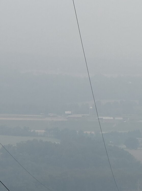
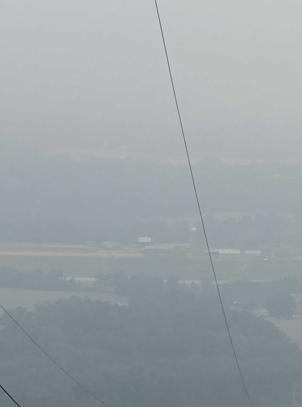
Like everywhere else, Williamsport has gotten better. Right before I went to bed around 5:30a I looked out and I could see the distant hills again which had disappeared and nearer things looked fairly normal. At 5:26 we had PM196 and visibility of 3 miles. Just now at 4:43p we had PM130 and visibility of 7 miles. Yesterday they said things will get worse later this evening. We shall see.
I hope I never look out and see almost everything near and far look different and much covered up by smoke like yesterday. But the way things are going, I probably will.
I think in the future I will think of fog in a different way. It will be a reminder of this week on the one hand but I will be so happy it isn't smoke on the other.