

CoralRed
-
Posts
320 -
Joined
-
Last visited
Content Type
Profiles
Blogs
Forums
American Weather
Media Demo
Store
Gallery
Posts posted by CoralRed
-
-
29 minutes ago, Mount Joy Snowman said:
I know this is not priority at all at the moment haha but I will ask again, did anyone receive measurable precip during the last 24 hours?
NWS has Montoursville Airport, 5 miles away from Williamsport, down for .01 at 18:54 and 20:54 last night, for grand total of .02 over last 24 hours.
-
 1
1
-
-
4 hours ago, Ruin said:
damn its the other way for me nws saying we get hit hard accurate and local mets are not impressed with it saying slush 1-2 or maybe most 1-4
This one was hard to pin down and once it looked like things were becoming clear at last, there was the big move south. We never did have a handle on it. It is still 36 at 1:45a at Montoursville Airport and while we are in blue for snow, lots of rain still happening in middle of the state like above Harrisburg. I figure things could go several ways for everybody and we will just have to see.
-
NWS and others say Williamsport gets almost nothing at under 2. AccuWeather still sticking with the prior program. I do not know why:
TONIGHT'S WEATHER
MON, FEB 12
Snow; rain mixed in early, accumulating 4-8 inches; slippery conditions may lead to travel disruptions Lo: 34°
Tomorrow: 1-3 inches of snow early in the morning; mostly cloudy and breezy; storm total 4-8"; dangerous travel in the morning with some improvement in the afternoon Hi: 41°
-
Less than two hours ago NWS had Williamsport at 6-9 in its Winter Storm Warning. They did say in their Discussion that things had shifted south but they were holding off on changing northern predictions for the time being. Now here is what they say: less than 2. So I guess there won't be much to report about up here. I am very happy for the people getting lots more than they thought.
TonightRain and snow showers, becoming all snow after 4am. Low around 32. Light northeast wind increasing to 5 to 9 mph in the evening. Chance of precipitation is 80%. Total nighttime snow accumulation of around an inch possible.TuesdaySnow showers likely, mainly before 9am. Cloudy, then gradually becoming mostly sunny, with a high near 37. Northwest wind 9 to 14 mph, with gusts as high as 28 mph. Chance of precipitation is 60%. New snow accumulation of less than a half inch possible. -
I noticed this over at weather.gov. We broke some records due to warmth. Between big drops in gas prices on the world market finally translating into lower UGI rates and a warm winter overall, I must say I am glad my gas bills are finally less:
.CLIMATE...
The following temperature record occurred during the mild weather on Friday and Saturday:FRIDAY FEBRUARY 9TH:
-High of 58 degrees at Williamsport tied the record set last year.
-High of 62 degrees at State College broke the previous record of 59 degrees in 2001.SATURDAY FEBRUARY 10TH:
-High of 53 degrees at Bradford tied the record set in 2001.
-Low of 35 degrees at Bradford tied the record maximum low temperature set in 2002.
-Low of 41 degrees at State College broke the previous record maximum low temperature of 39 degrees set last year.-
1
-
-
2 hours ago, Bubbler86 said:
You guys have great patience on this forum listening to all the LSV talk (including from me). Props to you.
I wish there were a lot more people here from the northern part of the state, not just us here in North Central PA but NE PA too. But there aren't. So we rely on you guys further south to keep things going. You do us a pretty big favor, if you think about it. You all keep the subforum going and I am very grateful for that. The northern handful can just chime in with opinions and reports as best we can.
-
 5
5
-
-
17 minutes ago, Wmsptwx said:
Asking for pawatch and I lol are we too far north or could we get okay totals?
Me too! I am in Williamsport and very curious as well. Looks like we could get something worthwhile out of this. I wasn't expecting that. Earlier today wunderground had just 1.4.
-
1
-
-
2:23a. Surprised to realize we are way off our westher.gov temp prediction -- by 10 degrees. I wonder if we will drop more? Are they going to update forecast?
Current conditions at Williamsport - Lycoming County Airport (KIPT)
OvernightMostly cloudy, with a low around 16. Southwest wind around 6 mph.Fair
6°F
Humidity 76%
Wind Speed Calm
Barometer 30.10 in (1020.3 mb)
Dewpoint 0°F (-18°C)
Visibility 10.00 mi
Last update 18 Jan 1:54 am EST
-
7 hours ago, ncforecaster89 said:
Hi everyone! I pop in here occasionally whenever I’m visiting my wife’s parents and her family in Lancaster…usually around Christmas.
That aside, I simply wanted to convey my great appreciation for your posts and respective first-hand updates (ground truth), so I can keep abreast on what they are experiencing there, as well.
I had told them to expect 3-5”…with the potential for 6”…two days ago, and definitely hoping that verifies. If I’m not mistaken, it requires about those amounts to do good sledding. If that projection falls short, they’re going to be extremely disappointed. Feeling pretty good about it, right now, though. Hope it’s an over-performer for each of you.
Thanks again,
Tony
Hi there. I am glad you spoke up this time when visiting us. Please feel free to chime in any time when you come to check out Lancaster weather. I am up in Northcentral PA in Williamsport. We have a cousin with her kids and grandkids down in North Carolina who come up here.
-
1
-
-
I just checked and we are due for more rain and warmth here in Williamsport than when I last checked overnight. Temp 54 at 11p, 53 at midnight then by 7a Wednesday down to around 40 where we stay for daylight hours tomorrow. About 2.25 on rain, before was under 2. We have been getting more snow too but of course that won't last on ground for long. Temps dropped a bit since snow started, from 36 around 8a to 33 now.
Very glad I don't have to leave house later when rain and wind pounding.
-
Major bust up here too in Williamsport. Montoursville Airport and rest of Lycoming County didn't even hit 4" when yesterday the ranges were something like 6-12 I think. One report was under 3"! Honestly I am relieved though. I got one of the viruses going around Saturday before Christmas, it is still hanging around and i am not in the mood for picking my way through snow and ice. I can only thank God the rain on Tuesday and moderate temps should get rid of this pretty quickly.
So I am sitting here very grateful things worked out as they did. But really surprised too, considering how far north we are.
-
Hard to know what to think for Williamsport as of 4:45p. Certainly looks like we will get more than I figured.
Winter Weather Warning still up and issued past noon says 4-8.
Now for Williamsport, NWS says:
SaturdaySnow, mainly after noon. High near 34. Light east wind becoming southeast 5 to 10 mph in the morning. Chance of precipitation is 100%. New snow accumulation of 3 to 7 inches possible.Saturday NightSnow. Low around 30. East wind 5 to 7 mph becoming light and variable after midnight. Chance of precipitation is 100%. New snow accumulation of 2 to 4 inches possible.For Southern Lycoming which includes us too of course, NWS says:
SaturdayA chance of snow in the morning, then snow in the afternoon. Snow accumulation of 4 to 6 inches. Highs in the lower 30s. Southeast winds 10 to 15 mph. Chance of snow near 100 percent.Saturday NightSnow. Total snow accumulation of 4 to 8 inches. Near steady temperature around 30. Northeast winds 5 to 10 mph with gusts up to 20 mph, becoming north after midnight. Chance of snow near 100 percent. -
Happy New Year, one and all, from Williamsport. I looked back to see if anyone else put this up and it looks like they haven't. As all eyes are looking ahead for snow, I am going to take us back a second to 2023 heat records. These are booby prizes of course in a warming world that we all wish weren't getting hotter, but still, we have two winners. Funny to think Williamsport hit its record for most snow of 25" just a few years ago on Dec. 16-17 2020. NWS said:
2033 was the warmest year on record in Williamsport, and tied for the second warmest in Harrisburg. RECORD ANNUAL AVERAGE TEMPERATURE STATISTICS VALUE YEAR Harrisburg (MDT) 56.9 2021 (2023 & 2020 = 56.7) Williamsport (IPT) 53.9 2023 (Supplants 2012 (53.8)) 11 of the top 13 warmest years on record have occurred since 1998 at Harrisburg (134 full years of continuous records). 9 of the top 13 warmest years on record have happened at Williamsport (128 full years) since 1998. 86 (of the possible 366) daily max temp records at Harrisburg have occurred since 2000, while only 35 min temp records have occurred in that same time period. Similarly for Williamsport,there are 83 daily max temp records on the books from the 2000s, while there are only 34 min temp records since 1/1/2000. In 2023: Harrisburg has set/tied 6 daily max temp records in 2023, and no min temp records. Williamsport very similar, scoring 4 daily max temp records, -
Unexpected News from Williamsport. This would be our first snow worth counting as anything up here, with an extra inch the next day. Weather.com says back to 48/38 by Tuesday though. Yesterday afternoon we had some relief from the curse of PA grey in the afternoon with actual big patches of blue for a while but the way things look now, I think we will have the predicted all-day dreariness today. Ugh. Still have to be glad no precip or low temps for tonight here in PA or in NYC for ball drop. The unpredictable factor for NYC will be potential protestor disruptions. I hope they skip it but I am afraid they won't.
Sat 06 | Night
31°58%ENE6 mphSnow showers. Low 31F. Winds light and variable. Chance of snow 60%. Snow accumulating 3 to 5 inches.
-
3
-
-
This demands to be shared so here it is:
-
12:55a: A midnight surprise. I have been skeptical about Williamsport getting any snow due to temps. Earlier tonight NWS said low would be 33, about 5 degrees lower than earlier; Wunderground still says 38.
So I am very surprised to see new Special Weather Statement calling for periods of heavy snow in certain places through 4a. They are putting very heavy emphasis on poor driving conditions. I am afraid lots of early drivers over here won't bother to recheck weather. They are talking lots more about driving hazards here than they usually do for a lot more snow. Hmmm.
Special Weather Statement
National Weather Service State College PA
1244 AM EST Mon Dec 11 2023PAZ019-026>028-035-036-045-046-049-050-056-110945-Southern Centre-Huntingdon-Mifflin-Juniata-Fulton-Franklin-Southern Clinton-Southern Lycoming-Union-Snyder-Perry-
1244 AM EST Mon Dec 11 2023...SNOW TO IMPACT TRAVEL EARLY THIS MORNING...
Rain has changed to wet snow across the higher elevations as of midnight and this changeover will work down to the valley floors by 2 AM.
The formation of one or more nearly north to south bands of
enhanced snowfall will create heavy snowfall rates of over 1 inch per hour through 4 am and drop the visibility down to just several hundred feet for a 15 to 20 minute period.Air and road Temperatures in the valley floors will remain at or
just above freezing through 2 am, while higher elevations over
1400 feet above sea level will see the road temperatures drop to around 30 degrees with the road surface becoming snow and slush covered. This will lead to poor traction and much extended braking distance that will greatly increase the threat for accidents if good driving practices aren`t used.Persons traveling overnight should be alert for a wide range of visibility and road conditions. Allow extra time for travel and
keep plenty of braking distance between you and the vehicle
ahead. Postpone unnecessary travel if possible until late this
morning. -
After looking at the last few pages of comments, some of which lack our usual friendliness, I am going to go ahead and lapse into poetry. Before anyone panics, it will not be my poetry (I don't have any) but that of the Russian author Boris Pasternak, who wrote Dr Zhivago and I am sure knew a lot about snow and drinking, too. What could be better than to read First Snow while talking about it?
First Snow
Outside the snowstorm spins, and hides
The world beneath a pall.*
Snowed under are the paper-girl,
The papers and the stall.
Quite often our experience
Has led us to believe
That snow falls out of reticence,
In order to deceive.
Concealing unrepentantly
And trimming you in white,
How often he has brought you home
Into the town at night!
While snowflakes blind and blanket out
The distance more and more,
A tipsy shadow gropes his way
And staggers to the door.
And then he enters hastily...
Again, for all I know,
Someone has something sinful to
Conceal in all this snow!
________
* Pall, noun: something that covers or conceals
especially : an overspreading element that produces an effect of gloom
-
3
-
-
Forgot to post this earlier. Sorry. WYOU in Scranton/Wilkes-Barre is having a weather special starting in a few minutes at 7:30.
Winter Weather Outlook will be a first as far as I know for a half hour show covering their snow predictions.
Glad to see snow getting the attention it deserves. Maybe other stations will start doing this too.
Update: I didn't see the middle as I was fussing with groceries and eating my donut. But I did see the end where they called for below average snow and possiblity of several Nor'easters coming up the coast. No snow map!
Williamsport's average is just below 36" so we could be below average but still get a lot more than last year.
-
Just saw this irresistible picture which is far more interesting with its blemishes and colors than the typical moon shot. Definitely zoom it up and look closely when you get a chance as photographer advises. It reminded me an atmosphere like ours is a wonderful thing to have.
It does not seem like a place for any advanced life from Earth to live however nor does anywhere else in our solar system, I'm afraid.
-
2
-
-
8 hours ago, Voyager said:
If he's the future of this country, we are in so much trouble...
I thought at first he was doing a fantastic takeoff on kids today then I thought no, I think this is really him and not a made up character. What seemed so great as comedy was the opposite of funny in real life.
-
No more Freeze Warnings for us up in Williamsport. Montoursville Airport is now 30 and we are supposed to go down to 28.
It is so strange to think that hit 75 just a week ago last Wednesday and I think the following day was 80. Plus of course on Sunday it will be completely dark before 5:30, I believe.
-
I was surprised to see when I got downstairs this morning that Williamsport was supposed to hit 69 or 70 later on. No such luck ... it never got past 62, which is what we are supposed to have tomorrow. Now that it is October 12, there won't be any more throwback weeks to summer where I have the windows open and it is in mid 70s or even low 80s for days.
I will have to get used to fall being here to stay plus force myself to accept losing an extra hour of light soon, on November 5.
Weather is such a heavy burden on the mind, isn't it?
-
40 minutes ago, Yardstickgozinya said:
I'm really looking forward to experiencing this storm in Baltimore. My gf is only a few blocks from the harbor. If it's not to hairy, I will walk down to the harbor and shoot a quick video to post when a good band comes in.
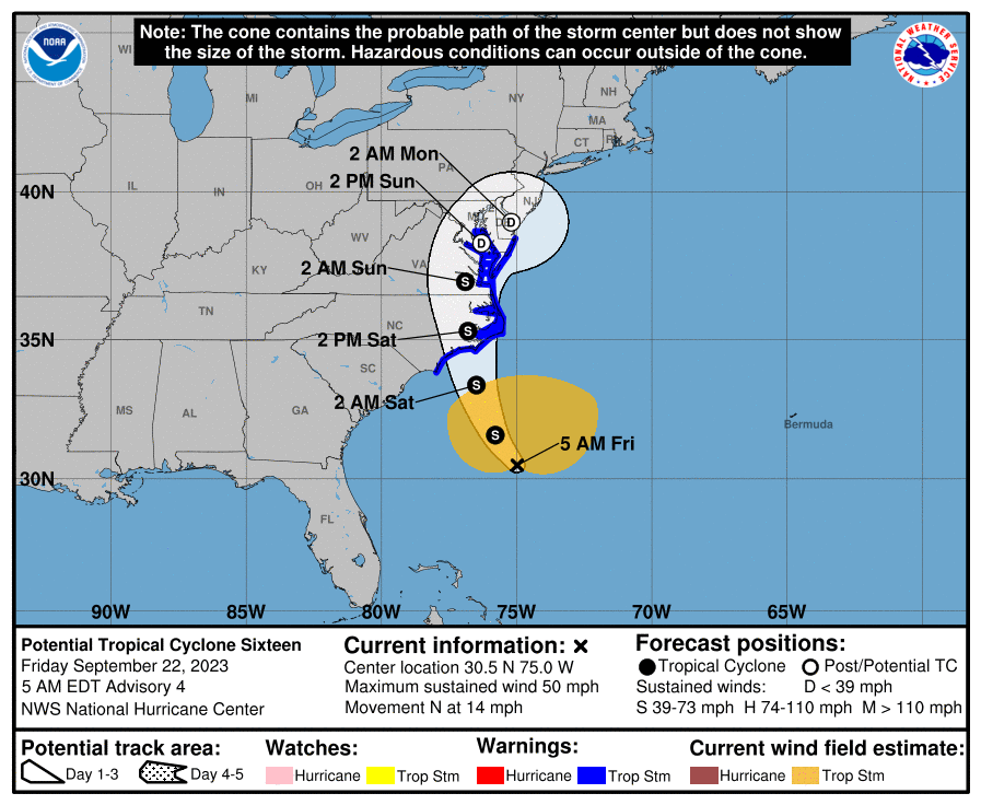
4:50a I see PA made the cone. I wonder when that last happened?
I was in Jersey City where I had lived for years, just 10 blocks from the Hudson and a few blocks from NY Harbor for Superstorm Sandy. I went down by the river and the harbor for the last time before it hit during the late afternoon of the day before, I think. I wish I could say I remember it well but I don't. There wasn't much going on as I expected but I wanted to see for myself. I kept going around the neighborhood and down to the river that weekend trying to imagine what would happen. I ended up talking to and then kind of clinging to a cleaning lady from a nearby building also there. We shouted our good-byes.
Lucky you will have your new girlfriend to cling to as necessary. I am definitely interested in seeing a video and hearing about what you see.
-
1
-
-
You raise some interesting points.
What countries have weather satellites focused on the Mediterranean? What countries track these storms and issue warnings? Don't the Big European Three of UK, France and Germany provide sufficient information and coverage for the smaller and/or poorer countries to the East?
-
1
-
Central PA Winter 23/24
in Upstate New York/Pennsylvania
Posted
I am so glad the show was worth the trip. I am going to do a little Williamsport promotion here. This is Williamsport's gorgeous Community Arts Center. It was the Capitol Theater when I was in school. We lost all three of our downtown movie theaters as far as first run movies were concerned by 1980. The newest one was demolished. The Rialto was taken over by a church and with a lot of help and hard work, the Capitol was transformed into this big beautiful space. No one would expect little Williamsport would have this gem but we do. If there's a show up here you're interested in, please come. You won't be sorry!