

wdrag
-
Posts
5,169 -
Joined
-
Last visited
Content Type
Profiles
Blogs
Forums
American Weather
Media Demo
Store
Gallery
Posts posted by wdrag
-
-
OKX radar showing Long Island lake effect light snow shower fragments translating east along the edge of the virga shield across Li. Take a look. I think the EC had this in some prior cycles for 00z/22.
-
 1
1
-
-
3 reports of flurries coastal Ocean County NJ at 745PM... no big deal I know, but not for naught. Always was fringe.
-
1
-
 1
1
-
-
Here depends where. se Tip LI to Cape May NJ will see brief snow sometime between 9 and midnight. Iso flurries around MD. Atlanta had a 3/4" in 1 hr ending around 430P. Close... not worth tracking for 99% of our subforum.
-
Yet again... suggest a flurry DCA-PHilly NY. Its roaring ne. Probably a near mss except coasts should get a short period of action this evening or as Dark Star implied..a whiff.
Per mid morning HRRR clipping NJ coast to e Li for 2 hrs around 02z.
-
1
-
-
Regarding other threads for January... none at this time though am looking at measurable snow in much of the subforum sometime between 06z/27-18z/30 (next week). but too soon for me to thread whatever the significance. Looks somewhat interesting.
AND, not to completely discard this Thursday-Friday for the coasts... not impossible to see patchy snow showers on the coasts sometime in there, but not looking quite as impressive (to me) as this marginal fringe snowfall potential ton ight along our coasts.
-
3
-
-
Tonight continues on the table. Attached the 08z/21 NWS probabilistic 1", 07z/21 BOM, 09z/21 SREF, 06z/21 GEFS (weakest, again most conservative), 00z/21 EPS, 00z/21 CMCE. Am hoping some folks on our subforum along along the coasts will be observing and reporting slight accumulations between 7PM and midnight (roughly), from a 1-4 hour period of snow showers. All models as I sampled vertically at Upton through the FSU MOE website show a chance of snow getting to the ground in that time frame. Lets see if the conservative BOM/GEFS win out with an offshore miss. A couple models show a chance for halfway decent dendritic growth (not just tiny flakes). Again and unknown on all but a wintry flavor.


-
1
-
1
-
 1
1
-
-
Hi.
Bluewave knows on EC. I let D8 determine planning for this thread and yes Canadian wasn’t good 48 hours out for LI. Not more I can say except well many know Canadian is a warmer model than GFS and EC
-
1
-
-
29 minutes ago, Volcanic Winter said:
Thank you Walt, your efforts are very much appreciated.
I was definitely paying attention for a bit of snow on snow, but yeah - modeling not looking good at the moment. We’ll see what happens.
HANG IN THERE... EC AI AND NAVGEM STEADY for e tip LI. Probably will miss and presuming the bl wind stays offshore, not happening for snow but the door is open slightly to adjustments for tomorrow night.
added at1246P. EC continues T-0.3" amounts along the NJ coast most of LI and now FAR se New England. Its edging N in GA/Carolinas.
-
1
-
-
15 minutes ago, donsutherland1 said:
The cutoff date for the number was through Sunday. Some of the snow will also be recorded with next week's update. Either way, the EPS missed the timing and likelihood of the snow from a week out.
I kind of agree... would you agree the CMCE was best guess a week out? Obviously being slightly too far west but having the right idea about w of I95.
-
2
-
-
Summary: You be the judge of the ensemble performance 8 days ago when this 88 page thread began. Added a bunch of CoCoRaHs data (as reported) to verify...more or less what happened yesterday-last night.


-
1
-
-
1 hour ago, wdrag said:
Don,
Think this needs a check if you include after midnight. BOS 5 inches. also I think ASOS WE is messed up at BOS after midnight and possibly the same at NYC but I can live more with NYC.
Later,
Walt
Don et al, while I'm aware this is based on cli reports... not sure what the agencies are verifying (EC in particular). Daily Cli, or 00z-00z or 12z-12z. I couldn't find any documentation on that but it may be that I didnt look closely enough.
So the perfection Don posted--- it is. I just didnt want anyone to think BOS 3.8.
I do know water equiv at some ASOS's is vastly underdone at non melting below freezing temps. Local offices probably modify the CLI reports via estimates, to try to keep the Climate Data base representative. I cant predict what BOX will do with the Logan ASOS qpf in the late afternoon CLIBOS report but Trace in that 6 hr period ending 12z, highly unlikely.
-
2
-
-
23 minutes ago, hooralph said:
Sadly, i think the 1.6" is not far off for Manhattan. My eyeball measurements would be more like 1.75; I don't think we got to 2".
You all are there. I kind of wish we had a camera on the board area 24x7 to match up to the ASOS there. I know there is UWS observer in our subforum. I cant keep up with all the chat here.
I also think the NWS and Feds at the White House could collaborate and get a daily observation going there using Climate accepted sensors and security vetted observation (security personnel?). The 0.4 at National doesn't seem representative of what I see on the White House lawn this morning. Minor point and not going to happen at both locations (CP and DCA) and this is why we regionalize snowfall info to not get to hung up on specifics. That harkens back to the PS/PC debate when we moved over to grids and wording from the grids.
I'll add the CoCoRaHs and NOHRSC snowfall analysis shortly for anyone to compare the initial thread ensembles vs reality and also the NWS multi sensor precip which showed 1/2" in the areas that I think got good banding, which also was well defined 24-48 hours in advance by the WPC snowbands extracted from the SPC HREF and confirmed by the FSU banding web site via the GFS.
-
2
-
-
2 hours ago, donsutherland1 said:
The final outcome:
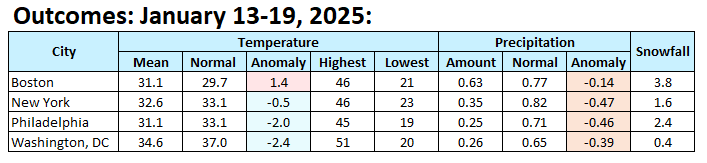
Don,
Think this needs a check if you include after midnight. BOS 5 inches. also I think ASOS WE is messed up at BOS after midnight and possibly the same at NYC but I can live more with NYC.
Later,
Walt
-
2
-
-
No further threads for storms. Looking at the 24th since many members at 5H are much sharper and concerning about 5H troughing down into the Virginias but for now, no thread.
-
1
-
-
No need to cancel this thread... no one is excited by it. However, keeping it going... will be a probable near miss for the coasts. The storm hasn't departed yet. I can live with a miss since it was always projected uncertain. IF it does snow coastal NJ and LI... it sticks. Don't give up yet s shore Li and coastal NJ, especially if pressure adjustments permit a north surface wind and a bit of NNE boundary layer trajectory late tomorrow. Right now, not.
-
1
-
-
Will add some CoCoRaHs maps at 10A for snowfall. Canadian-RGEM too robust-amped and tucked in I95 west though that's where the heaviest occurred. EC AI was helpful. I want to check melted w.e. at 10A as well. This also takes a chunk of confidence away from the dry EPS weeklies- here is what was available to us at initial thread time on the 11th...pretty depressing EPS dry swath ne USA for the 13th-20th. Just tells me the that guidance beyond 5 days is shaky on qpf. Fortunate to get this one more or less right at D8. Impact up here for most of the NYC subforum I think was generally moderate for a few hours... briefly high where it snowed at 1+/hr and temps were falling below freezing at sunset Sunday. I did check flightaware and google maps for flight cancels and roads in and around NYC. More at 10AM

-
1
-
-
The very minor event the night of the 21st-early22nd along the coast might be more of CFP with steep lapse rates, decent snow growth snow showers, rather than the nw fringe of the departing se USA storm. For now lets keep it going.
Have seen the 24th possible event but no action til late Monday at the earliest. It does seem to have possibilities of eventually looking as a nice snow event but holding off at least 24 hours - 8PM Monday the 20th, til it looks better with all modeling.
Then the sw USA closed 5H low next weekend will eventually send some GMEX moisture newd toward us as the 5H low moves bodily to the Easton the Rockies or splits eastward with ptype issues?
-
4
-
2
-
-
-
7 minutes ago, jm1220 said:
Looking at DE and E MD that’s probably our chance to really accumulate east of the city when that pivots in. We need that to last a couple hours at least.
Have some confidence. N shore of LI will do well... might see some 4 and 5s...not done there til at least 1A.
-
3
-
-
17 minutes ago, MGorse said:
You can all you want. I am here to try and clarify. Bitching here won’t get your feedback to where it needs to be.
In a little defense of the NWS... they work within the mapping constraints that are set by NWS region-nationally.
The forecast team answers your ph calls, including reports, they keep the forecasts updated as much as they can and then its out of their hands when all the updates transmit. They keep the emergency managers updated including government officials.
Its sundown now and temps generally below freezing NJT westward into PA with wintry precip, mostly snow and some of that at rapid rates. If you go out in the next few hours and slide off the road or slip on the sidewalk, they did all they could to advise you. Forecasts are imperfect and sometimes forecasts are less than desired but I suggest ride this one out through 8PM.
-
2
-
-
Mt Pocono area 2.5". my space in southern Wantage NJ 5P report 1/19/25. 2.5". Includes 1.7" snow increase past hour. 26F. Have seen a remark of over 3" in another part of Wantage.
-
2
-
-
26 minutes ago, sussexcountyobs said:
That's amazing since you are only a 20 minute drive up 23? I'm eyeballing maybe 2.5-3" right now. Will measure when I go out to shovel in a bit. Steady snow falling. 25.9°
now 0.8 and 1/2S
-
3
-
-
41 minutes ago, sussexcountyobs said:
Mod- occasionally heavy snow continues. Just measured 2"
25.9°
VERY NICE!! way ahead of the part of the SC where only near 1/2".
-
1
-
-
4 MTR sites with 1/4 S+ in se PA now...should advance ne next several hours. have had very little the past 90 min. stuck near .4" so far in Wantage NJ. Other places se of Wantage in NJ doing better.
-
2
-


Discussion-OBS (if any) for Tuesday afternoon-night (Jan 21-early 22) northwest fringe snowfall from the departing southeast USA winter storm.
in New York City Metro
Posted
KMIV, KWWD, KACY reporting minor S- since ~730PM.