SchaumburgStormer
-
Posts
5,575 -
Joined
-
Last visited
Content Type
Profiles
Blogs
Forums
American Weather
Media Demo
Store
Gallery
Everything posted by SchaumburgStormer
-

January 10th-12th Winter Storm Potential
SchaumburgStormer replied to Thundersnow12's topic in Lakes/Ohio Valley
-
January 10th-12th Winter Storm Potential
SchaumburgStormer replied to Thundersnow12's topic in Lakes/Ohio Valley
The backside better be rocking or everyone is going to embarrassingly bust. (Poor WI crew, from a 20” big dog to advisory levels in a couple models runs hours before onset) -
January 10th-12th Winter Storm Potential
SchaumburgStormer replied to Thundersnow12's topic in Lakes/Ohio Valley
Just a little shift. Classic NAM. -
January 10th-12th Winter Storm Potential
SchaumburgStormer replied to Thundersnow12's topic in Lakes/Ohio Valley
Seasonal trends will not be denied. -
January 10th-12th Winter Storm Potential
SchaumburgStormer replied to Thundersnow12's topic in Lakes/Ohio Valley
-
January 10th-12th Winter Storm Potential
SchaumburgStormer replied to Thundersnow12's topic in Lakes/Ohio Valley
And wayyy east. Tracks the low over cleveland. -
January 10th-12th Winter Storm Potential
SchaumburgStormer replied to Thundersnow12's topic in Lakes/Ohio Valley
12z Euro looking even weaker and more bleh area wide. -
January 10th-12th Winter Storm Potential
SchaumburgStormer replied to Thundersnow12's topic in Lakes/Ohio Valley
I wouldn't throw it out, but I would discount it a bit as overly amped pending the 12z Euro. -
January 10th-12th Winter Storm Potential
SchaumburgStormer replied to Thundersnow12's topic in Lakes/Ohio Valley
GFS drier/East Big time disappointment for our WI guys lined up for a big dog. -
January 10th-12th Winter Storm Potential
SchaumburgStormer replied to Thundersnow12's topic in Lakes/Ohio Valley
Let do this one. -
January 10th-12th Winter Storm Potential
SchaumburgStormer replied to Thundersnow12's topic in Lakes/Ohio Valley
Yeah, huge sensible weather impacts across the transition zone. Social media is certain to be full of people slaying LOT "I got snow and you told me it would rain" or "I was prepared for ice and cancelled my plans, and it just rained". So many factor in play and it shows with such differences this close to onset. -
January 10th-12th Winter Storm Potential
SchaumburgStormer replied to Thundersnow12's topic in Lakes/Ohio Valley
Garbage seasonal trends will not be denied -
January 10th-12th Winter Storm Potential
SchaumburgStormer replied to Thundersnow12's topic in Lakes/Ohio Valley
Weaker and wimps out pretty significantly on precip.
-
January 10th-12th Winter Storm Potential
SchaumburgStormer replied to Thundersnow12's topic in Lakes/Ohio Valley
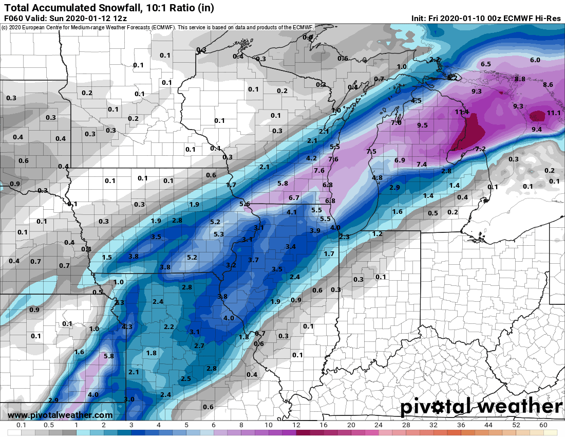
00z euro with a sizable south jump. Several inches of snow into the metro -
January 10th-12th Winter Storm Potential
SchaumburgStormer replied to Thundersnow12's topic in Lakes/Ohio Valley
Seems these setups always surprise one way or the other. So many factors at play, that even a small change has significant sensible weather impacts someone is getting snow that doesn’t expect it, and vise versa -
January 10th-12th Winter Storm Potential
SchaumburgStormer replied to Thundersnow12's topic in Lakes/Ohio Valley
My kids are going sleet sledding. -
January 10th-12th Winter Storm Potential
SchaumburgStormer replied to Thundersnow12's topic in Lakes/Ohio Valley
Going to be pouring pingers like I have never seen if the bam is to be believed -
January 10th-12th Winter Storm Potential
SchaumburgStormer replied to Thundersnow12's topic in Lakes/Ohio Valley
Glacier incoming. .5" of ZR with an inch of sleet. -
January 10th-12th Winter Storm Potential
SchaumburgStormer replied to Thundersnow12's topic in Lakes/Ohio Valley
Looks solid given guidance consensus (tossing the GFS) -
January 10th-12th Winter Storm Potential
SchaumburgStormer replied to Thundersnow12's topic in Lakes/Ohio Valley
Pingers for dayz -
January 10th-12th Winter Storm Potential
SchaumburgStormer replied to Thundersnow12's topic in Lakes/Ohio Valley
NAM in line with the GFS/Euro in terms of track. -
January 10th-12th Winter Storm Potential
SchaumburgStormer replied to Thundersnow12's topic in Lakes/Ohio Valley
Shame that multi-zone for Cook isn't active till March. Would be a perfect storm set up to utilize it. -
January 10th-12th Winter Storm Potential
SchaumburgStormer replied to Thundersnow12's topic in Lakes/Ohio Valley
-
January 10th-12th Winter Storm Potential
SchaumburgStormer replied to Thundersnow12's topic in Lakes/Ohio Valley
Low track is further south than the last run. Edit: disregard. Ends up pretty close to earlier run. -
January 10th-12th Winter Storm Potential
SchaumburgStormer replied to Thundersnow12's topic in Lakes/Ohio Valley
Euro is going to be an ice crush job for N IL