Hoar_Frost
-
Posts
489 -
Joined
-
Last visited
Content Type
Profiles
Blogs
Forums
American Weather
Media Demo
Store
Gallery
Everything posted by Hoar_Frost
-
Pre-Christmas (Dec 21-23rd) Winter Storm Part 2
Hoar_Frost replied to Chicago Storm's topic in Lakes/Ohio Valley
Find the cold front.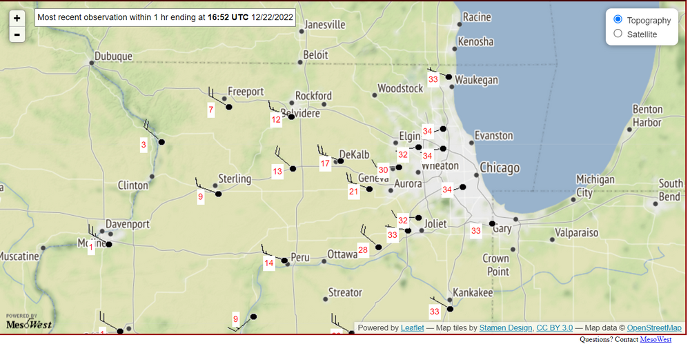
-
Pre-Christmas (Dec 21-23rd) Winter Storm
Hoar_Frost replied to Chicago Storm's topic in Lakes/Ohio Valley
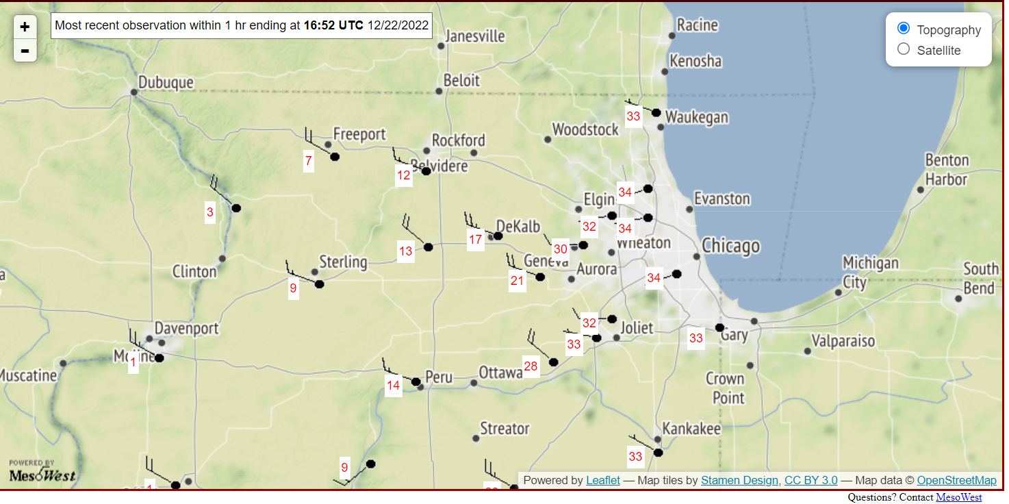
Though the amount of snow that's likely to fall in Illinois and Wisconsin, and possibly Indiana and Michigan, appears that it will be reduced compared to what guidance suggested yesterday, I think trying to do "verification" on a feature 48 to 72 hours before it has even happened seems a bit misplaced. I think some of this commentary would be more valid if, come Friday evening, only a couple of inches of snow, in fact, fell. Since I'll be up in the Fox Valley, I am hoping for a lot of snow, so the recent model trends are just as disappointing to me as they are to many of the rest of you. Just to be clear... -
Pre-Christmas (Dec 21-23rd) Winter Storm
Hoar_Frost replied to Chicago Storm's topic in Lakes/Ohio Valley
Even a couple of inches of snow with such high winds during a high-impact holiday travel period in a city that is home to one of the busiest airports in the country will cause many problems. If one of the snowier solutions plays out, that'll just exacerbate those problems. I can understand why LOT is hitting it hard early. -
2022 Short/Medium Range Severe Weather Discussion
Hoar_Frost replied to Chicago Storm's topic in Lakes/Ohio Valley
I'm back to living in the Midwest as of earlier this month after about 10 years away (Pennsylvania then Florida then Pennsylvania again). I live in downtown Lafayette, Indiana, and am working as a climatologist and data programmer for the Midwestern Regional Climate Center at Purdue University. We had some wind gusts to 40 mph and a good 75 minutes of moderate to heavy rain. There seemed to be a lot of dust suspended in the outflow ahead of it, which I found interesting considering that it rained last night. -
Central PA - Winter 2021/2022
Hoar_Frost replied to Bubbler86's topic in Upstate New York/Pennsylvania
I agree. I suppose we'll see what the next shift at CTP does. -
Central PA - Winter 2021/2022
Hoar_Frost replied to Bubbler86's topic in Upstate New York/Pennsylvania
This is only tangentially related to the storm, but the point forecast for State College for tonight's low temperature, 5 degrees, if it verifies, would be the lowest temperature here since 2 February 2019. -
December 16 2020 CTP Snowstorm Disco and Obs
Hoar_Frost replied to pasnownut's topic in Upstate New York/Pennsylvania
That sounds about right. As far as 24-hour totals go, today was the 12th time a 24-hour total of 15" or more was recorded at State College since records began in the 1890's and the first time that has happened in December.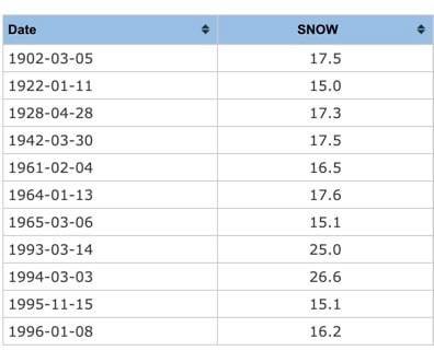
-
December 16 2020 CTP Snowstorm Disco and Obs
Hoar_Frost replied to pasnownut's topic in Upstate New York/Pennsylvania
I will look for sure in a bit, but it might be on par with a 2010 storm. Otherwise, probably best since '96. -
December 16 2020 CTP Snowstorm Disco and Obs
Hoar_Frost replied to pasnownut's topic in Upstate New York/Pennsylvania
I cleared the board four different times. My current snow depth, which includes that kind of settling, is ~15", so that's consistent with your measurement. A friend in Woodycrest (located between you and me) had similar measurements as me. My liquid equivalent was 1.32", a 14:1 snow-liquid ratio. Pretty legit storm for the Happy Valley, though, either way! -
December 16 2020 CTP Snowstorm Disco and Obs
Hoar_Frost replied to pasnownut's topic in Upstate New York/Pennsylvania
Yep, in State College, near the Wal-Mart on North Atherton. A couple of friends nearby on the north side also measured similar. I just woke up and am going outside in a few minutes to see what the balance of the storm left. EDIT: Final measurement was 2.9" since 11:00 PM, yielding a final total of 19.1". -
December 16 2020 CTP Snowstorm Disco and Obs
Hoar_Frost replied to pasnownut's topic in Upstate New York/Pennsylvania
7.2" from 7:30 to 11:00 PM. Storm total so far: 16.3". -
December 16 2020 CTP Snowstorm Disco and Obs
Hoar_Frost replied to pasnownut's topic in Upstate New York/Pennsylvania
Snow intensity is starting to increase again here. -
December 16 2020 CTP Snowstorm Disco and Obs
Hoar_Frost replied to pasnownut's topic in Upstate New York/Pennsylvania
Another 7.0" of snow (since 2:30) here in the Park Forest section of State College. Storm total so far: 9.1". -
Central PA - Winter 2020/2021
Hoar_Frost replied to MAG5035's topic in Upstate New York/Pennsylvania
2.1" so far (as of 2:30 PM) at my place in the Park Forest section of State College. +SN at the moment, visibility ~1/5 mile.