

tombo82685
-
Posts
13,428 -
Joined
-
Last visited
Content Type
Profiles
Blogs
Forums
American Weather
Media Demo
Store
Gallery
Posts posted by tombo82685
-
-
30 minutes ago, tombo82685 said:
that 8-14 day outlook to me is highly dependent on how mjo verifies. Could see that going warmer if mjo propagates faster towards maritimes. If gefs are right, then colder look will be correct
Should say, I think beginning of that period holds the cold, could be moderation for back half of that if euro guidance is right
-
8 minutes ago, tim123 said:
System snow was 10to 12 to 1. 3rd wave was 20 to 1 lake effect higher. So average was 15 16 to 1. Just like what kuchra showed.
roch airport measured 1.11 qpf with 13.1 snow, avg 11.8-1 ratio. buffalo had 1.02 qpf with 9.7 snow for a 9.7 total, thats 10.5-1 ratio. This is through midnight last night. Where are you getting these 15/16-1 avgs? Even @DeltaT13 said those maps are wrong and he lives in the same county as you.
-
 1
1
-
-
4 minutes ago, tim123 said:
And you guys laugh when I point out high ratios. Smh. Not you wolfie just some others on here.
this is lake effect, which verifies, no doubt. It's the synoptic event in which they did not verify, where numerous people have pointed out to you
-
 3
3
-
-
7 minutes ago, BuffaloWeather said:
There will be snow chances with these temp outlooks.


that 8-14 day outlook to me is highly dependent on how mjo verifies. Could see that going warmer if mjo propagates faster towards maritimes. If gefs are right, then colder look will be correct
-
2
-
-
4 minutes ago, TugHillMatt said:
Thanks for this great writeup! MJO seems to rule the day these days. Hopefully we can have some more solid winter before Spring. We have really only had about a month of it.
In some years it certainly does, in other years the PV does. Last Feb was PV driven that cold with the ssw. But yea, really up to how the mjo propagates through IO and into maritimes and at what speed.
-
1
-
-
31 minutes ago, TugHillMatt said:
So what do you guys think for the rest of the month? It's looking like mixed signals. SYR, BGM, and Albany may have trouble getting to even 50% of average. SYR has the best chance of the three, and very likely will.
Forget about the strat for remainder of the winter, that is record strong. Despite the strong SPV for most of the winter, there has been a notable disconnect between the TPV and SPV which has allowed for brief intrusions of high latitude blocking across the Arctic domain. That looks to come to an end as it looks like the SPV and TPV look to finally couple. Can see how all the blues have been stuck above 300hpa, that looks to change by Presidents Day. So that could signal to a possible warmer than normal March. In terms of February there are some weak intrusions of -AO.

To me the biggest difference if you look at the 2 ens guidance the gefs and eps is how they handle their mjo forecast. The eps/euro mjo goes right into phase 4 which is warm for us with more zonal flow across the US with a +epo. If this were the case, would favor northern tier as cold air might be tough to come by

The gefs bring this into phase 2 then 3, then slowly work towards 4. Thats a much colder forecast and would promote much colder weather with more wintry impacts. Can see on the gefs OLR starts in eastern IO then slowly propagate towards Bay of Bengal.

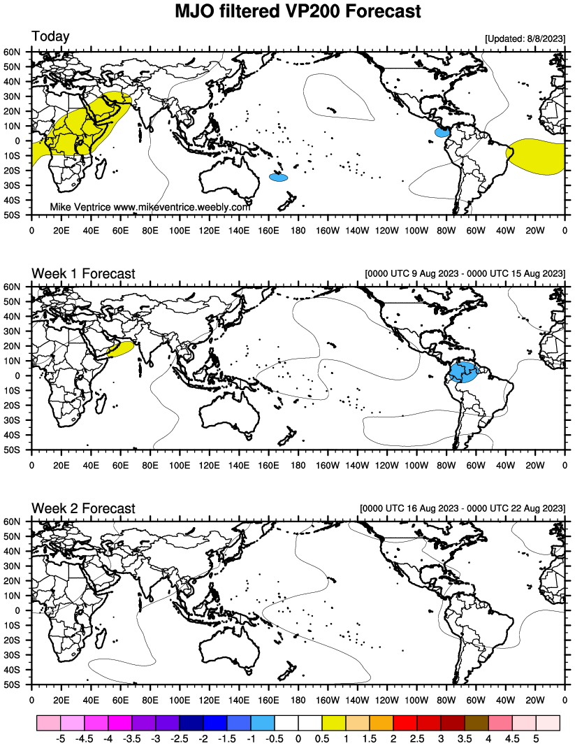
Looking at the VP maps, definitely would support more convection firing in the eastern IO than what the euro would advertise and would be a nod to the gfs mjo forecast
 http://www.atmos.albany.edu/student/ventrice/real_time/twc_globe_mjo_vp200.png
The roundy mjo plots which I love and think grab convection tendency the best would show the phase 2/3 emergence but quickly go towards phase 4/5 into maritimes which would support warmer pattern

So it basically comes down to which MJO forecast is correct. The gefs seem to slow to me with its wave propagation and would tip my cap towards euro evolution going off roundy plots. The euro looks wrong to me with not pushing this into phase 2/3 more before heading into 4.
-
1
-
4
-
-
.2 of lake effect over night. 11.5 for total. almost 55" on the year.
-
1
-
-
39 minutes ago, wolfie09 said:
It doesn't look like much on radar but it's pure powder keg lol

Dang, really? Looks very light on radar. Guess arctic air overhead squeezing out some decent moisture
-
31 minutes ago, wolfie09 said:
Maybe I'm missing something here lol 0.6" of liquid x 30/1 ratios would be 18" of snow.. Ratios would be more in line of 13/1..
You weren't missing anything, clearly I was lol
-
2
-
-
16 minutes ago, DeltaT13 said:
Recheck your math. 8/.6 = 13:1
lol, yea my math failed me there
-
 1
1
-
-
lowville coop melted down .6 with 8" of snow. Not sure if that liquid number is right, but thats like 30-1 ratios. Seems pretty high honestly.
-
1
-
-
5 minutes ago, TugHillMatt said:
Rain.
No I’m talking qpf wise. Wpc had 1-1.25 but he showed the map for last 24hrs. What fell prior qpf wise?
-
3 minutes ago, wolfie09 said:
Models definitely busted high on total precipitation.. WPC had the whole area at around 1"-1.25" of total precipitation which clearly didn't happen.. Downsloping did take place right where the models had it, lacona only picked up 2.9" of snow.. Here idk, didn't measure lol But it was enough to at least get me some morning exercise with the blower...
.gif.d31d42dc608de8242465dc311a6461e3.gif)
.gif.86a86397151ece874ad10f279eac6421.gif)
wasn't that forecast for the entire event? What fell wednesday night into Thursday AM?
-
this last wave under some decent returns looks like lake effect stuff. Big dendrites coming down.
-
1
-
-
it was pure powder up here, granted I'm much colder up here. It was dense, but powder
-
2
-
-
14 hours ago, TugHillMatt said:
What happened to our colder weather for after this storm? Looks like mid to upper 30s all of a sudden much of next week. What has happened to the days of yore with highs in the 20s and replenishing snow showers?
Looked to me beginning to mid part of next week always looked more seasonable to slightly above as the flow gets a bit more zonal. Colder look starts later in the week and the flow goes more meridonal. I like how the pattern looks going forward. Not overbearing cold, but cold enough for snow and active as the mean trough axis looks to be to our west. Should cause a storm track closer by. Then looks like a lot of northern stream disturbances too.
-
3
-
1
-
-
9.4 here, 14 otg. Hoping that 3rd wave brings additional 1-2. temp 11
-
seriously, nothing beats a good bourbon on a cold snowy night
-
2
-
-
Just now, TugHillMatt said:
Sounds like a good competitor for that Yerdon lady in N. Redfield who takes 5,000 pictures of herself cheerleader jumping off snow piles.
how does that make you feel Matt, tell us from the bottom of your heart
-
4
-
-
1 minute ago, Syrmax said:
Drifts or real?
believe perrysburg has good elev like over 1400 so could be some upslope enhancement
-
1
-
-
2 minutes ago, Syrmax said:
Yes, that's what most models were Spitting out for KSYZ. One caveat, we are a bit N of KSYZ and the soundings I was looking at were for the airport. If heaviest qpf is from SYZ to say Cortland, just to my south, wouldn't shock me to see the city end up a bit better than here. OTOH, we're halfway to double digits and a long way to go yet...so we may end up ok given the ratios I just measured...
Yea and would think with any decent omega later on with cooling thermals aloft would increase chance of a bit better ratios
-
1
-
-
2 minutes ago, BGM Blizzard said:
Yup or Zr in the higher terrain like kbgm is reporting right now. The tri-cities airport in Endicott reported light snow and 27° and their 6 miles south of me on the banks of the Susquehanna around 890ft elev... not sure I buy that one.
Whats the vis at tri cities, that should tell you whether it's legit or not. I highly doubt snow if the bgm is zr. Could be happening is lower elev than airport giving more time for rain droplets to freeze. Probably pelting with maybe a few needles thrown in
-
1
-
-
1 minute ago, Syrmax said:
I'm at 19F...
yea, gotta be lack of omega which lays that out well with lack of qpf. Didn't most models have like 1.2-1.4 for cuse area qpf wise lol?
-
1 minute ago, Syrmax said:
Ok, so just did some measurements. Everything was clean at 0800 this am.
0.45" melted
5.0" snowfall.
Ratio: 11.1:1
Ratio Better than i thought. Just not getting the qpf, yet?
thats not bad. Yea sounds like issue is qpf. Whats your temp down there? Its 15 here


Feb 2-4th Snowstorm- Observation Thread
in Upstate New York/Pennsylvania
Posted
whatever county it is in, still holds same merit.