

Quincy
-
Posts
6,164 -
Joined
-
Last visited
Content Type
Profiles
Blogs
Forums
American Weather
Media Demo
Store
Gallery
Everything posted by Quincy
-

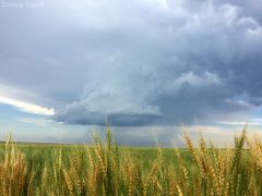
From the album: Spring/Summer 2015
Mammatus clouds fall behind shades of yellow and green wheat. -
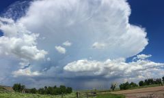
From the album: Spring/Summer 2015
A low precipitation (LP) updraft is developing, but struggles to gain height in the atmosphere. This storm was weakly rotating, but began to dissipate shortly after the time of this photograph. -

From the album: Spring/Summer 2015
Mammatus clouds overlook a weakly rotating LP updraft in the distance. -
From the album: Spring/Summer 2015
This towering thunderstorm was beginning to get out of focal range for the camera, as the tops are missing from this photograph. -
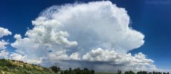
From the album: Spring/Summer 2015
This thunderstorm, which developed very rapidly, begins to drop rain onto the Colorado countryside. -

From the album: Spring/Summer 2015
A thunderstorm, aided by atmospheric instability, explodes into the air over rural north-central Nebraska. June 6th, 2015. -

From the album: Spring/Summer 2015
A pair of funnel clouds reach down into the sky just north of Hartville, WY. June 3rd, 2015. -

From the album: Spring/Summer 2015
A thunderstorm, not severe, slowly begins to fade away into the sunset. Photo taken from near Monango, ND. June 2nd, 2015. -

From the album: Spring/Summer 2015
A supercell thunderstorm begins to form over Cambridge, NE. May 15th, 2015. -
A bit of a localized, conditional severe risk tomorrow - most notably around the TX/OK panhandles. A subtle vorticity lobe is progged to move from NE NM/SE CO through the southern High Plains with lee surface cyclogenesis late in the day/evening. Although boundary layer dew-points are rather low at the moment, in the mid-40s to mid-50s across the area, southerly flow beneath a retreating warm front should result in modest to moderate instability reaching the TX panhandle by 00z Thursday. Upper level flow is fairly anemic, but 0-6km shear should be sufficient for supercells and backing of low-level winds should result in sizable hodographs by early evening. A rather modest setup, but one that could result in a few robust supercells. I can see an isolated tornado threat developing, assuming moisture return is considerable enough and shear reaches the levels currently forecast. Storms may merge into a small complex into the evening, posing a marginal damaging wind threat eastward across the panhandles. The way this year has gone, marginal/modest setups like this have been fairly common, although the results have generally been below expectations. I'm not an expert on climo for the panhandles, but I would venture to assume this is rather late in the season for a setup this far south?
-
I thought it was odd given the S to SSE flow ahead of the cold front, strong instability and modest deep layer shear. It wasn't like the setup didn't have at least a marginal tornado threat signal. It wasn't until an MD after the damage that a brief tornado threat was mentioned. We've seen 2% tor probs for weaker signals.
-
Could see some isolated severe storms on either side of the SD/NE border this afternoon. At least based on mesoanalysis, conditions seem more unstable than most progs. Large to very large hail appears to be the most likely hazard. Tomorrow looks messy (#2015ing) with respect to storm mode/evolution. Perhaps the most probable significant threat will be damaging winds/hail via MCS in the evening. The focus is in SD and areas to the immediate east/southeast.
-
Multiple funnel clouds down here, but I haven't seen anything conclusive yet as far as touchdowns. In the Greenwood section at the moment.
-
Too much warming around 700mb, but the cap is starting to erode a bit. Would expect at least one or two intense supercells at the over the next 1-4 hours. Most likely in west-central Missouri. Perhaps lose to the southeast side of KC metro.
-
The severe potential is really going to heavily depend on the track and coverage of the morning MCS. The HRRR seems to be a bit more expansive, while the NAM is quick to weaken. The NAM solution shows strong to locally extreme instability developing in its wake. Even the latest HRRR shows moderate instability already in place near the MO/KS border by 17z. We'll have to see how convective trends look in the morning for more clarity. At the very least, as mentioned above, some areas are going to see quite a bit of rain. The NW flow and trajectories would probably favor some training too.
-
Seeing some intriguing forecast soundings from both the NAM and GFS for southeastern Kansas into west-central Missouri tomorrow. Ongoing convection is one of the biggest issues, although if some storms can develop on the southwestern flank of that action, they'll be tapping into a forecast environment that is very supportive of severe thunderstorms. Looking closer, it appears that the models want to develop a small area of low pressure near the KS/MO border. Another convoluted setup that has many issues, but nonetheless, SPC did introduce a SLGT risk area in the 1730 Day 2 outlook.
-
The Aberdeen sounding didn't make it past 400mb, but there was no shortage of shear observed. I wasn't monitoring this threat closely, but the setup now includes a modest 1008mb surface low in eastern ND with moderate instability, favorable wind shear, a nicely timed vorticity lobe and the region lies on the nose of a 45-50kt 500mb jet. 00z mesoanalysis was showing in excess of 250 m2s-2 0-1km SRH near the most vigorous storms. Looking at tomorrow, I don't think the setup is nearly as volatile, but I'd suspect there is a decent amount of severe thunderstorm activity across Missouri and vicinity. The directional shear does not look at favorable as today was. There is also a lack of clarity on the placement of a (secondary?) surface low. WPC was pinning this near the KS/MO border tomorrow afternoon with a warm front segment across northern MO. While the RGEM was similar, the NAM/GFS keep the main low moving SE through Iowa and a cold front dropping south through KS/MO. Nonetheless, any outflow boundaries from overnight/early day convection tomorrow could come into play tomorrow afternoon. Instability will not be an issue and shear would support supercells. This is echoed by the 4km NAM simulated radar progs. However, if we are dealing with more of a cold front and winds are out of the SW ahead of it, the tornado threat will probably remain low end/marginal. The upper level winds are progged to be NW to NNW, so there will still be decent directional shear, even without backing winds near the surface. Analog guidance showed several events with a corridor of severe thunderstorm reports, including tornadoes, extending from the eastern Dakotas/Minnesota, down into Missouri.
-
The environment isn't particularly impressive to the south (weak shear), but moderate instability and steep lapse rates are helping. Can't imagine the southern storms latest severe too long. Much stronger wind shear across Nebraska and some guidance favors upscale growth with a cluster eventually making it to northern Missouri overnight. Wouldn't be surprised if that convection stays robust for a while. As a front/boundary shifts south, may actually see some storms across Oklahoma and Arkansas tomorrow that could feature some severe wind/hail.
-
There is the potential for a regional severe weather event on June 22nd. The threat zone extends from portions of the middle/upper Mississippi Valley into the western Great Lakes. All severe weather hazards are possible and given the nature of the setup, forecast trends are being closely monitored. As at least two pieces of shortwave energy rotate from the upper Midwest into the Great Lakes on Monday, a surface low is forecast to deepen from Iowa/Minnesota into Wisconsin. Impressive wind fields for this time of the year will combine with strong instability to create an environment favorable for severe weather. As it stands right now, two rounds of storms are expected. The first round would most likely be in the form of a mesoscale convective system (MCS) Monday morning, moving into the Great Lakes by midday and early afternoon. The second round develops in the wake of this activity, at and shortly after peak heating, later in the afternoon. The setup is a bit complicated and there are reasons to believe that two rounds of mixed intensity are favored over one robust atmospheric punch. The MCS during the first half of the day could pose a threat for primarily damaging winds and isolated hail. Once that system moves out, there should be modest air-mass recovery. The issue is that wind fields in the lower levels begin to veer, causing a more unidirectional shear pattern. This will likely dampen the tornado potential somewhat. Nonetheless, even forecasts on the more conservative end of the spectrum indicate a setup favorable for at least a few tornadoes. The afternoon to early evening threat may feature fairly widespread damaging winds, if storms were to merge into a linear system. Supercells still appear probable and they may extend into the early evening. However, for the reasons listed above, this does not look like an ideal setup for a major severe weather outbreak. Trends for this event tend to move the surface low a bit quicker, which also speeds up the veering of winds. The best wind fields may also become somewhat displaced to the northeast of stronger instability to the south. The Euro has joined the GFS/NAM in developing strong instability, as earlier it was showing a less unstable setup. The RGEM is also on-board and all of the models are in general agreement in terms of timing and geographic placement. Wisconsin is the target for the initial MCS on Monday. That system should weaken as it moves into portions of upper and lower Michigan. Later in the day, the target becomes southern Wisconsin and northern Illinois. Portions of lower Michigan and northwestern Indiana may also get in on some action. Damaging winds should be the predominant threat. The stronger cores can produce large hail and a few tornadoes seem probable. At least one of the following scenarios would need to occur to more fully maximize the tornado threat: First, outflow from the morning MCS could work to set up one or more boundaries to locally enhance a tornado threat. If the MCS decays faster than projected, that could lead to less disruption of the wind field and even stronger instability. A mesoscale low and/or a main low tracking further south into southern Wisconsin (instead of northern sections) may maintain more backing in the lower level wind fields through the threat zone. It should be noted that even with the projected wind fields, at least a few tornadoes remain likely. Given both a strong low level jet and 0-6km shear in excess of 50 knots, there is at least some potential for strong tornadoes. All of the factors currently forecast likely place Monday into more of a mid-range (SPC moderate risk) severe weather threat, as opposed to a higher-end (SPC high risk) outbreak. Stay tuned to later forecasts to see how the forecast setup evolves. The NAM forecast below for 21z Monday shows winds veering substantially across Wisconsin and Illinois:
-
A severe thunderstorm threat is expected to develop late this afternoon into the evening hours across portions of the northern Plains. The setup includes an area of surface low pressure ejecting from Wyoming toward the Nebraska/South Dakota border late today. At the same time or shortly thereafter, an embedded upper level shortwave swing through the Dakotas. The combination of kinematic support and strong instability will likely result in several severe thunderstorms with all severe weather hazards possible. The severe weather threat may continue well into the night as storms shift east-southeastward. The computer models are in good agreement with the synoptic setup and even most of the mesoscale details seem fairly clear. The HRRR/NAM/RAP show an area of low pressure moving into east-central Wyoming by late afternoon with isolated thunderstorm development across much of eastern Montana. The initial development is closer to the upper level forcing at the time and in association with a frontal boundary interacting with moderate instability and modest wind shear. Further east, although stronger surface heating/instability are progged, a fairly strong cap should limit convection for most of the afternoon. Between about 22z and 00z, surface heating looks sufficient to begin breaking the cap. At this time, robust thunderstorm development appears likely across southeastern Montana and far northeastern Wyoming. In the immediate downstream environment, a secondary warm front/differential heating boundary is showing up with the high resolution guidance. As it looks now, that should be draped roughly near the I-90 corridor from far northeastern Wyoming into the western half of South Dakota. It is here that strong instability and increasing wind fields should be very favorable for severe thunderstorms. Any discrete thunderstorms between 23z and 02z near this secondary boundary are expected to have the highest probability to produce tornadoes. The higher end instability scenarios appear overdone, but even the less dramatic GFS shows in excess of 2500 J/kg MLCAPE overlapped with 60 knots of bulk shear through much of western South Dakota. Given such instability, the initial threats appear to be large to very large hail, followed by isolated tornadoes. A more substantial damaging wind threat likely develops during the evening hours further east. As the low level jet really ramps up and upper level winds increase, the kinematic environment should support a significant MCS, possibly a derecho. The exact placement of this convective system develops on how and where thunderstorms grow upscale. It appears that beginning in northwestern and moving into central South Dakota is where the model consensus stood as of this morning. This is also supported by an intense inflow environment with moderate elevated instability and a vigorous low level jet (in excess of 50-60 knots) ejecting from northern Nebraska into portions of South Dakota. While the convection-allowing models differ slightly with solutions, they all show an elevated threat of fairly widespread damaging winds into early Saturday morning across much of South Dakota. This is a fairly interesting case, as this portion of the (western) northern High Plains does not have many significant tornado cases dating back to the early 1960s. One of the red flags for tornado development includes storm coverage as a result of capping. Nonetheless, regardless of geographic region, it is possible for a strong tornado to develop given the expected environment. If a strong tornado were to form, this would most likely be in western South Dakota or perhaps far southeastern Montana/far northeastern Wyoming. Compared with climatology, the projected severe weather parameters tonight fall into the high end of prior tornado cases for the region. Although wind fields intensify into the evening hours, a gradual loss of heating and a trend toward storm mergers may also mitigate the threat. The threat of most widespread impact will likely end up being damaging winds, even if a derecho does not form. For what it’s worth, the 09z SREF derecho probabilities are in excess of 50% for a large portion of South Dakota by 06z Saturday. A few severe thunderstorms are also possible across southern North Dakota and a rogue supercell cannot be ruled out in the Nebraska panhandle either.
-

Central/Western Medium-Long Range Discussion
Quincy replied to andyhb's topic in Central/Western States
I would still expect at least one or two decent severe weather events between Thursday, June 18th and Sunday, June 21st. The Euro/GFS aren't in the best agreement with specifics, but both advertise some high CAPE/modest shear environments. Of course, the best kinematic support will likely remain displaced to the north. Still, with sizable areas of 3000+ J/kg MLCAPE progged for at least some of the period and decent winds upstairs, it's worth keeping an eye on. Either way, as mentioned, nothing in the High Risk category should be expected. If anything, I'd suspect multiple SLGT/ENH risks in the period. The aerial coverage for such threats should remain on the smaller side, unless model guidance takes some sudden shift back into the "right" direction. -
As the calendar passes deeper into June, there is typically a steady drop-off in the frequency of severe weather threats across the U.S. Last year featured a grand finale to the severe weather season with a fairly significant sequence or tornado events across portions of the north-central U.S. from June 16th to 18th. While this year will likely not see quite an intense show as June 2014, there could very well still be some respectable severe activity with tornadoes. Mid-June of this year has been on the radar, so to speak, for quite some time. While there are still some model differences, it would appear that at least a couple of days between Thursday, June 18th and Sunday, June 21st should feature at least localized severe weather events. Note that there is some isolated potential before June 18th, this article will focus more so on the 18th onward. With it only being the 15th and plenty of time for forecasts to change, it is too soon to get into specifics. There are at least two main ingredients that would appear to favor severe weather, more-so, perhaps, than the U.S. has seen over the past week or so. Strong to possibly extreme instability is projected to be in place. Both the GFS and Euro show sizable areas of of 3000+ J/kg MLCAPE. The upper level flow is shifting toward a more zonal pattern, at least in the larger scale. An increasingly tight height gradient is likely from the central/northern Plains into portions of the Midwest by the end of the week and into the weekend. This is expected to result in a stronger component to the winds in the upper levels. The result is favorable forcing aloft and enhanced wind shear with any shortwave energy that ejects through. There are always caveats and red flags. While there may be more severe weather ingredients to work with, the overlap of those parameters may be relatively small. For example, while 500mb flow may be in excess of 50 knots for a time during this period, the best instability will almost certainly remain displaced well to the south and east. This in itself should tend to favor a more localized severe weather risk. Nonetheless, the Euro and especially the GFS progs over the past several runs highlight(ed) the period in and around June 18th to 21st. The potential exists for severe weather, possibly significant, including tornadoes somewhere in the region between the northern half of the Plains to the western Great Lakes. At the very least, some high CAPE/low shear setups are likely. The questions will become, how large can the threat zones extend and will some of the more impressive shear overlap with stronger instability? Take a look at some forecast soundings for this weekend if you want some severe weather eye candy. It is silly to take these progs too seriously at this point, so we will have to wait and see how the forecasts evolve. A broad geographical area is highlighted here and it will not be until the short-term that exact threat zones can be confidently identified. Nonetheless, at least one or two solid chasing days are predicted between Thursday and Sunday. If you are willing to travel or on a chasecation, there is reason to be cautiously optimistic about the storm chase potential coming up.
-
Similar today is similar to, but somewhat less impressive than yesterday for the southern High Plains. Decent obs coming out of far southeastern New Mexico into portions of Big Bend country as of midday. Though an isolated tornado is possible, probably near the NM/TX border, the bigger threat should be large hail - like yesterday. Slowly moving storms and yet another threat for MCS action in west Texas up into the panhandle this evening.
-
Looks like an initial risk for severe storms in western Texas quickly transitioning to more of a flash flood/damaging wind threat after dark via MCS.
-
Despite the wind fields aloft not being terribly impressive, low-level shear and instability (via NAM) look strong enough to support some supercells, if storms can remain discrete. New 12z analog guidance showed at least 50% of similar setups produced one or more tornadoes in the Texas panhandle. The threat would probably extend east into western Oklahoma if the latest data is correct. FWIW, the analog guidance would suggest a SLGT to ENH risk.