

Quincy
-
Posts
6,220 -
Joined
-
Last visited
Content Type
Profiles
Blogs
Forums
American Weather
Media Demo
Store
Gallery
Posts posted by Quincy
-
-
I’d say the range of scenarios start at being similar to last Wednesday and that’s hoping either it’s a convective mess or there is some sort of cap that tempers the warm sector... and higher end being a generational event. Hard to envision an evolution without at least a couple of intense, long track tornadic supercells. The wind profiles and lapse rates alone also suggest a much greater large hail threat than we saw last week.
-
 1
1
-
 1
1
-
-
Speaking of analogs, very clear signal (multiple runs) on either side of the MS/AL border area for significant, long-track tornadoes. (Based on prior events, but it is a mixed bag in terms of severity, as @Chinook mentioned.)
-
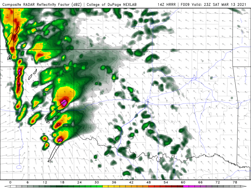
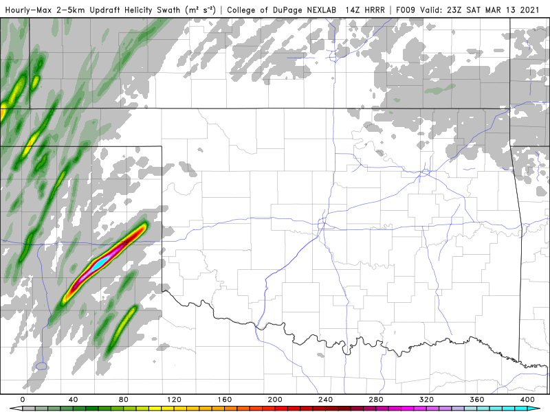
FWIW, GFS shows a broad area of >7 C/km 700-500mb lapse rates over 68-71F dew points. (yes, some of the area is under convection) You don’t see this very often this far southeast during a severe event.
-
Wednesday wasn’t a colossal bust. Sure, there wasn’t much activity over the western heart of the moderate risk, but several long track supercells produced numerous tornadoes over Alabama.
Thursday was even more fickle.
Remember that SPC produces probabilistic outlooks. Just because the “odds” of a tornado max out at one point does not mean that this is exactly where tornadoes will form. Tornadoes are microscale phenomena and very complex.

-
5
-
-
3 minutes ago, PackGrad05 said:
Would you say that the probability of no tornados per unit area in a high risk area is the same as a tornado per unit area in the slight risk area?
Areas in the high risk had tornados. A majority of the tornado reports (as of that graphic) were in the high area. What percentage of the high risk area needs to have a tornado for it not to be considered a bust?
You could argue that sliver of the slight was also a bust since it had numerous warnings and a tornado report... or could you?
This is a time sensitive version of the PPF (practically perfect forecast):

There is some debate that the CIPS PPF method isn’t the best. I’d reference Gensini’s enhanced version tomorrow, once it updates.
https://atlas.niu.edu/pperfect-
3
-
-
6 minutes ago, jrips27 said:
Hail threat really busted today as well. Spent 45 minutes getting squeezing three cars into a two car garage here just east of Birmingham for nothing lol. BMX was saying tennis balls.
I don’t think I saw any reports of anything bigger than quarter sized?
I feel like the large/significant hail threat with these events in the Southeast often end up underperforming. You just don’t get the steep lapse rates aloft very often in this area that you do across the Plains. Plus the thermodynamic profiles are moist with higher precipitable water values than you’d ideally see for significant hail soundings.
3/19/18 on the other hand... (very different type of setup)
-
The DDC flukey tor appeared to happen near the warm front/low intersection. It seems like we get at least 1-2 events a year where the main focus is over TX/OK and a seemingly random tornado spins off near Dodge City...
-
1
-
-
Core punched the Paducah storm. A lot of hail, but mostly sub severe. Followed it closely from behind for over a half hour and never saw anything conclusive. Just a raggedy, low cloud base.
Looks like the severe threat with this event is ramping down. Quite a few rain-wrapped tornadoes, that I had no business getting close to.
-
Also had a close call on a muddy road. Managed to wiggle out. Could have been a much worse situation. It was a 3 mile bypass thanks to Google Maps. Started paved, otherwise I wouldn’t have taken it. Had to continue or I would have been destroyed by hail. Not one of my finer chase moments
Tornado from earlier:
-
3
-
-
Saw a brief cone tornado around 4:05ish to the east of Happy, just before passing through the canyon. Interestingly, the cell embedded in the north side of that cell is the long-tracker that keeps going.
-
May have spoken too soon. 20z AMA RAOB shows VBV in the mid-levels, but can’t argue with how it’s evolving now. Oof.
-
Just now, stormdragonwx said:
Theres also a lot of haze and cloud cover that hasn't cleared off as expected. Reminds me of May 20th, 2019.
I was chasing the storms around Nazereth, but it was very messy. Lots of blowing dust and haze. Cool inflow as well. Not gospel, but car thermo was showing 63-65F. Saw plenty of scud/appendages, but it looks like it’s forming a line. The road network doesn’t give much breathing room, so heading toward the Caprock.
Low level lapse rates are still marginal across the SE panhandle region, but better moisture and modest heating appears to be advecting that way.
Messy so far, but not that far off from CAM solutions.
-
Will throw this surface map in here for reference. 71/62 at CDS now.

-
1 hour ago, stormdragonwx said:
Is it a bad assessment to say this looks like 3/18/12 on steroids? This is crazy for March. Feels more like a day in May.
Definitely a different setup, although the time of year and placement of the greatest tornado risk are similar. That event had a broader risk area up and down the high plains. The one similarity would be some bulging of the dryline in the Texas panhandle.
A key difference is 3/18/12 had a surface low in Wyoming and here we’re looking at a surface low in the Texas panhandle with a focused threat area near and immediately east of the dryline bulge/triple point vicinity.
Despite some residual cloudiness, CDS has shot up to 68/62 as of 17z. Vernon, TX is up to 75F already. Lubbock is 63F, but you can interpolate that 70s are not far away. Moisture quality is often a concern this early in the season, but not so much today. Mesoanalysis shows a broad area of >8 C/km 700-500mb lapse rates across NW Texas. Wind fields are very favorable. Even though mid/upper level winds are SW, the initiating boundary should be draped NNW-SSE. Surface winds are backed to southeasterly.
Seems to be a fairly solid setup with the only caveat being some storm mode concerns. Even there, you could see a long lived supercell or two, even if cells get a bit clustered.
Let’s see what 2021 has to offer.
-
4
-
1
-
-
-
I think we went all of May without a single moderate risk?
This image is both staggering and telling about the past few months. The lack of tornado watches across the Plains, north and northwest of the I-44 corridor is remarkable. Just ridiculous having gotten through most of the peak tornado season...
-
1
-
 1
1
-
-
-
Chased a lone supercell in a general thunderstorm area today. CAMs were inconsistent, but the environment easily favored a supercell. Started near Lusk, WY and ended up near Chadron, NE.
-
1
-
-
Edwards from SPC sampled 3.2” hail from that storm:
-
Chased the initial, easternmost supercell in South Dakota today. Managed to avoid the hail and didn’t have issues with the reservations, as the storm curved right and stayed over open road networks.
-
35 minutes ago, The Iceman said:
I went through and counted the filtered tornado reports on the spc website and I believe there are only 51 tornado reports nation wide so far this month. Has to be on pace for some kind of record? Can anyone chime in?
The last month of May in the U.S. with less than 100 tornadoes was 1970 with 88.
http://www.tornadohistoryproject.com/tornado/1970/5/map-
2
-
-
3 minutes ago, Chinook said:
We've had a couple of tornado warnings east of Pueblo CO that have been for confirmed tornadoes tonight.
The setup tomorrow is a bit similar with a bulge-type feature leading to a locally enhanced area of low-level shear. Wonder if it’s a repeat, but will keep that talk to the other thread.
I bailed on the Montana chase idea today. They did have a few transient supercells, but didn’t want to get too far out of position for tomorrow or play around with the complications that come with out of state travelers there. Even though I barely had any contact with anything there, outside of my shoes on the ground.
-
Quick glance for the deadly Louisiana tornado...
About 35 knots of bulk shear with 500mb winds out of the NW, backing to SW at the surface. Marginal MLCAPE ~500 J/kg, however there was sizable 0-3km MLCAPE around 100 J/kg. A localized area of 200-300 m2/s2 0-1km SRH was also noted.
LCH didn’t launch a RAOB, but the 00z 5/18 SHV sounding gives a rough idea of the mid to upper profile. There was more backing of low level winds where the tornado occurred, resulting in larger 0-1km hodographs.
https://www.spc.noaa.gov/exper/soundings/20051800_OBS/ -
1 hour ago, TexMexWx said:
Deadly EF3 tornado confirmed from Louisiana yesterday... The atmosphere can really surprise us. Does anyone know what the environment in that area was like at the time of the tornado(es) there? I basically paid no attention to it considering it had been a general t-storm risk area
I’ll take a look into this...
Had a few transient supercells in Montana today, but the instability axis was too narrow and meager to support anything more. Tomorrow’s setup is in the same general area, except moisture return should be better.
Severe Event March 25th 2021
in Southeastern States
Posted
You would hope for a cap as well, given the fact that early day convection lifts north and could very well leave down multiple boundaries... that’s one of the key differences between a significant event and a super outbreak.