

Quincy
-
Posts
6,220 -
Joined
-
Last visited
Content Type
Profiles
Blogs
Forums
American Weather
Media Demo
Store
Gallery
Posts posted by Quincy
-
-
Ongoing derecho across the High Plains. It’s not too common to see such expansive convective systems so far west in the states. The lack of discrete activity ahead of the line may have helped maximize potential instability downstream as well. Moderate risk is in effect for widespread damaging winds.
-
Barring some evening miracle, today’s prospects for any surface-based supercells appear to be cooked.
-
Chased a lone supercell in a general thunderstorm area today. CAMs were inconsistent, but the environment easily favored a supercell. Started near Lusk, WY and ended up near Chadron, NE.
-
 1
1
-
-
The ridge across the Central Plains should begin to break down this weekend. At the same time, a belt of seasonably strong upper level winds (60-80kts at 500mb) should pivot around the base of a Great Basin/Rockies trough. The trough will gradually move east, impinging on favorable low level moisture and thermodynamic profiles for severe storms Saturday through Monday.
The action starts Saturday with a large area of convective activity likely from the Rockies into the High Plains and eastward across the Dakotas. At this point, convective modes look to be mixed with one or more sizable MCSs developing.
The setup resets for Sunday and there is the potential for a break in the action as capping prevails during much of the day. The focus appears to be over the Dakotas/Minnesota vicinity. Convective modes could be more discrete than Saturday, but there is still a lot of time for the forecast to evolve.
Yet another active severe weather day is possible on Monday, but models begin to diverge to some degree and Cristobal may influence the upper level pattern as well. Regardless, more severe storms may be possible from the eastern Dakotas/mid-Missouri Valley into the Upper Midwest.
Throughout the period, deep layer shear will be more than sufficient for organized severe storms, along with dew-points rising through the 60s and sizable instability profiles. Saturday could even get a bit interesting over the Rockies, where seasonably impressive wind profiles may overlay just enough instability (generally less than 1,000 J/kg) for high terrain severe storms as well.
-
Edwards from SPC sampled 3.2” hail from that storm:
-
Chased the initial, easternmost supercell in South Dakota today. Managed to avoid the hail and didn’t have issues with the reservations, as the storm curved right and stayed over open road networks.
-
On 5/28/2020 at 2:22 PM, cheese007 said:
Where is that ghost town? Would love to visit it!
Doole, TX, it’s northwest of Brady, about midway between Brownwood and San Angelo.
-
1
-
-
Attempted to chase today. With no radar or other data for four hours, when storms initiated, I decided I’d play as far south as possible. That seemed to be a good idea. The tail end of a cluster of convection broke off into supercells that paralleled I-10 down to San Antonio. I ended up in two tornado warnings, but neither storm had noteworthy low-level rotation. I had to dodge supercells on both sides of San Antonio before calling it a night.
It was probably the worst Verizon black hole I’ve encountered anywhere in the Plains. Only parts of eastern Colorado could possibly rival it.-
1
-
-
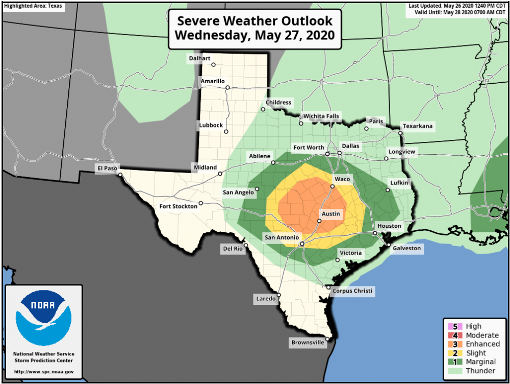
I've taken a closer look at tomorrow's threat across Texas...
Area averaged sounding from the 00z hrrr at 20z/3 p.m. CDT for approximately a four county area just west of Waco shows that convective initiation (CI) is imminent. Convective temperatures are in the mid-80s and that is the same from other high resolution CAMs as well.
Note that low-level shear is weak and even the 850mb jet is much weaker than you'll see under most ENH risk areas. With that said, deep layer shear is more than sufficient for supercells and moderate CAPE profiles thanks to cool temperatures aloft should result in several large to potentially very large hail producing storms. While not particularly large, 0-3km hodographs are enlarged, thanks to NW winds at 500mb backing to S/SE at 850mb. In addition to weak low-level shear, seasonably lackluster dew-points seem to imply that the tornado threat is very limited during the first few hours of storm development. (dew only around 60F in the initiation zone at this latitude in late May is unimpressive)
Most CAMs show an initially supercellular storm mode, but the NSSL and multiple WRF members show clustering/upscale growth within a couple of hours. The HRRR, HRRRv4 and 3km NAM hold onto a semi-discrete mode until at least 22-23z, before things get messier toward 00z. It's hard to predict MCS evolution since the CAMs are not in the best agreement, but I would think that the highest risk for a damaging MCS would be near/east of I-35 after 22z. An MCS seems very likely by 00-01z, moving toward the Texas coast during the night.
Basically, on the lower end of expectations, I'd think there are a couple of initially supercellular storms that produce large to possibly very large hail before storms grow upscale. If storm modes remain more discrete, as storms encounter an air-mass with richer low-level moisture to the southeast and the low-level jet, then the tornado threat may increase. If we dissect the tornado threat, I'd say it's very low, but non-zero through 6 p.m. and then increases toward sunset, assuming storms are still at least semi-discrete by that point.
-
1
-
-
3 hours ago, stormdragonwx said:
I know its outside of the range for this discussion thread but does anyone have thoughts on the TX setup for tomorrow? Trying to make the most of this lackluster season and since I am off work till Friday I'm considering taking a shot at it even if it is a 12 hour drive one way. Though the pattern looks to be about the same as its been this year with messy HP storm modes and SSE storm motions from my initial look at the models. Either way I'm surprised there hasn't been more talk on this setup.
This setup kind of went under the radar until SPC upgraded. I’ve been watching it. Some people have mentioned “veering” winds, but upper level winds look NW. Theres actually quite a bit of turning with some forecast soundings showing NW 500mb winds backing to SSE near the surface. The hodograph is rotated almost 90 degrees from a “typical” late May event in central Texas.
I need to take a closer look with 00z guidance tonight, so far it looks like CI may occur relatively early in central Texas, but the environment gets increasingly favorable by late afternoon. I’d probably watch the tail end storm and there are is even a conditional threat for SW Texas (maybe down near I-10) could see an intense storm or two early in the evening. At least based on the parameter space, if the cap can be broken. Storm modes are probably going to be messy toward the N/NE edge of the risk area.
-
Chased a supercell near Del Rio, TX today. Saw some robust updrafts on the Mexico side of the border, but this storm was the one I was focused on:
One of the rare chases south of I-10 that actually produced something worth chasing.
-
1
-
-
Currently chasing this hail-producing supercell that is moving from Baca County, Colorado toward the Kansas border.
-
Extended the thread for one more day. Today looks like a broad area with multiple targets, while tomorrow is a bit more focused on central/western Texas. Beyond tomorrow, the pattern across most of the Plains looks relatively benign for late May standards.
-
An inversion is defined as temperatures rising with increasing height. A capping inversion usually refers to a stable layer above the boundary layer where temperatures rise.
The 00z LBF sounding does show a cap with -76 J/kg MLCIN. This is a good example of a traditional cap:

Refer to a 2hr near term RAP sounding valid at 23z near Goodland, KS. There’s about the same amount of MLCIN (-72 J/kg), but there is no capping inversion. The cause for CIN is largely tied to relatively dry boundary layer air. The convective temperature is 85F, but forecast and actual temperatures were only in the upper 70s.

For some reason this year the default explanation for any severe event not panning out is that there was a cap. I just don’t see a cap last night over northwestern Kansas.I had some good dialogue last night on Twitter about the bust. In addition to cloud cover, limited surface heating and dry air, the evolution of the dryline was key as well. As the dryline bulged, it actually curled in on itself. Not only did this feed drier air north, but it caused shear vector orientation issues. Instead of deep shear vectors being oriented orthogonally with the dryline, messy angles and lazy storm motions prevented parcels from ingesting more favorable moist low-level air that was displaced to the northeast.
-
I'm not sure where the warm 700mb idea came from, but several people have been mentioning it on Twitter and elsewhere. 700mb temperatures were around +10C when I looked this afternoon and there wasn't much of a capping inversion in place. However, an area of CINH was analyzed over northwestern Kansas, likely a result of clouds limiting surface heating and somewhat lower dew points than forecast. Note that convective temperatures in northwestern Kansas were in the lower 80s, but temperatures struggled to get above the mid/upper 70s.
I've spent the past hour and a half writing a post mortem about this:
-
Just now, Chinook said:
Today has certainly had some excitement, with 6 zones of severe weather.

Late May has a way of squeaking out severe, even if regional (or even local patterns) don’t look particularly favorable. Yesterday had some sneaky severe reports too.
-
Current storm NW of Goodland is still displaced a bit too far west of an area with much better low-level moisture to the east. I’m watching it and it’s still somewhat elevated and attempting to organize. If it can hang on for another 60-90 minutes, then the tornado threat will begin to substantially increase.
-
1
-
-
The environment near the western KS/NE border is going to rapidly become very favorable for tornadoes around and after 7 p.m. Let’s see what happens.
-
Fairly high confidence in a corridor with intense supercell potential from northeastern Colorado into southwestern Nebraska on the nose of a lee cyclone. The parameter space should become very favorable toward and just after 00z for a couple of tornadoes. Forecast soundings show enlarging hodographs and more than ample instability.
I wouldn’t be surprised if SPC adds a small ENH risk area, but then again, they’re not predicting for storm chasers.
The environment in northwestern Kansas also looks conditionally favorable for an intense supercell, but capping and less focused forcing lead to some uncertainty there.
-
Put up a thread on Twitter to go into more detail. Just pasting to save typing. If I was going to pick a conditional target area, it would be western North Texas into southwestern Oklahoma. Maybe near Wichita Falls. A storm could thread the needle, but I expect mostly an HP mess.
-
Not sure what to make of today. The atmosphere is recovering across Oklahoma, but not quite enough. The convection surge has pushed all the way to the Arklatex, outrunning sufficient deep layer shear for supercells.
The outflow boundary in western North Texas looks the most intriguing. Large CAPE and marginal shear. The intersection with a dryline and/or cold front are interesting, but CAMs have been performing poorly and may not be resolving CI in the right areas
My gut says we see messy blobs of convection by mid to late afternoon. We’ll see.
-
1
-
-
I opted for the tail end Charlie near Liberal, KS. When I got there, it was struggling and I almost went home, but I’m glad I didn’t.
This supercell reintensified and an even better organized storm popped up to its immediate west. I watched this slow moving, distinctly structured supercell for about an hour before it got dark.
Got lucky with the lightning self portrait, even though it’s a little cut off. Camera was set to 1/15 and the first shot wasn’t in focus. The second happened to catch some lightning off to the side.
-
2
-
-
Kansas mesonet obs show dews mainly in the mid to upper 50s around southwestern Kansas, about 2-4F lower than these obs:

-
Wind profiles are not ideal today, but I’d expect semi-discrete storm modes for at least the first couple of hours before an MCS begins to develop.
Tomorrow’s setup heavily depends on the nature of the MCS overnight/early tomorrow and where the outflow boundary ends up. I could foresee targets ranging from western North Texas to southern Oklahoma or the eastern Oklahoma/Ozarks vicinity. Some CAMs suggest the OFB may linger near or retreat back to I-44 in Oklahoma, but I am skeptical about that.
Here’s another vantage point of the scene I captured last night:
-
1
-


Severe Threats: June 6-9, 2020
in Central/Western States
Posted
The NW MN/far NE ND area looks maximized for tornado potential. Dew points already in the mid to upper 60s with a warm front gradually lifting north. Some of that risk probably spills into Canada, but I think the front in NW MN is where the best shot at prolonged discrete/semi-discrete supercells is.
There could be a secondary area farther south in South Dakota, particularly the tail end of where convection unzips along a front.
Between the two areas, it’s probably quick to upscale growth. One positive factor is the cold front looks slow-moving at best, maybe acting more like a stationary front. That may allow for a few storms to thread the semi-discrete needle, but we’ll see.