

OHweather
-
Posts
4,957 -
Joined
-
Last visited
Content Type
Profiles
Blogs
Forums
American Weather
Media Demo
Store
Gallery
Posts posted by OHweather
-
-
I would say be careful, you have a fair amount of margin for error before mixing comes into play and I don't think that becomes a concern north of Rt 30, but we've seen worse trends. Given that mixing is a long way from being a legitimate concern and it'd have to trend considerably weaker (when the overall trend the last several cycles has been more amped) this one looks pretty good for northern Ohio...5 days to go...
-
Casually peaked at radar and some storm reports through the day...nice to see the rare WNW to NW flow event that isn't short on moisture.
-
 1
1
-
-
43 minutes ago, NEOH said:
CLE mentioned that the trough has become diffuse. Looks like wherever the heaviest/convergence band sets up it will stay there awhile since the flow doesn’t shift much. Hoping that isn’t too far to the east.
Yeah, wherever the best band sets up could still see a few inches as winds don’t move a ton, I just don’t think it’ll be that intense. Winds are roughly 290 and reasonably strong so I certainly think the Cleveland metro and southern Snowbelt should see something.
-
Tonight-Wednesday's leg of the event doesn't look as impressive for NE OH as yesterday when I looked...looks like the Euro idea of keeping the deep moisture farther east will pan out. There's a little shear but it's a reasonably well-aligned WNW flow for quite a while through Wednesday afternoon that isn't too strong with just enough instability and inversion heights of 5-7k feet, so there will still be accumulating snow probably from northern Lorain County points east, but I just don't know if the intensity will be there for more than a broad 1-4" of additional snow, focused wherever the convergence band develops and maybe in the higher terrain of northern Geauga as well. NW PA still gets into the deep moisture with a longer fetch and more terrain, so additional amounts in eastern inland Erie County will still probably justify the warning, especially since some of those areas already have 6-12" and will probably get that much more...though west of I-79 there will likely be a drop off somewhere to much more pedestrian amounts.
-
Looks like two shots for some snow the next few days...first Monday night into Tuesday morning with some initial wrap-around and lake enhancement...my impression is it's 2-4" in the higher terrain of Geauga and 3-6" for the higher terrain of Erie PA and SW NY through Tuesday afternoon...it's an ok but not outstanding setup, synoptic moisture decent but winds rather westerly and instability limited. So there should be accumulating snow in the usual spots, maybe pushing advisory criteria for some, most likely in parts of Erie County and the Chautauqua Ridge. The next period is Tuesday night and Wednesday when the models drop another vort max and good moisture through. The Euro is more of a clip job for NE OH while the NAM would be very good back into NE OH. With a WNW wind, colder temps, and longer duration, that's the window that could produce a substantial accumulations perhaps worthy of a warning...highest confidence again in the higher elevations of NW PA/SW NY, though if the NAM is right (and it's only a small shift west for the Euro) that could get as far west as the higher terrain of Medina County. A prolonged lake enhanced event with decent ratios, upslope and broad shoreline convergence with a WNW wind, and good moisture and instability would do quite well.
-
1
-
-
1 hour ago, NEOH said:
Looks like the trough has stalled in the middle of the lake. With high pressure quickly building in its going to be tough for the band to move any further south than ashtabula county.
Yeah, that band got amazingly stuck.
-
I suspect a better band will flare back up within an hour or two as the rather sharp trough moves across the lake...it won't be 2" per hour like they saw from Erie to Dunkirk this morning but should be moderate at least. The question for some of you will just be how far south it can get.
-
9 minutes ago, Benadrill said:
What do you think about Tuesday?
I think northern OH sees a light snow, but it’s not a strong system and temps aren’t that cold so probably a 1-2” deal (less near the lake). Maybe some LES behind it but that doesn’t currently look fantastic.
-
The NE corner of Ohio and parts of Erie County got a good amount this morning, already a 9” report SE of Erie. Hopefully the bands are intact later and can make it far enough south for some of you to see something.
-
Since it's been pouring and 45 degrees here all afternoon/evening, one more pass at this...
A band will ramp up over the lake this evening by 7 or 8 PM as the first of a few troughs pushes across the lake. Winds ahead of the trough are WSW if not SW, so this initial band will likely set up parallel to the shore and come inland into Buffalo and its immediate southern suburbs. Temperatures ahead of the trough are cold enough for plenty of graupel given the developing instability, but don’t quite get cold enough for a change to all snow and potential accumulations until after it passes. This band will likely push inland a bit and shift south of the Buffalo area by 11 PM or Midnight as the trough passes. Winds behind this trough briefly come around to about 270 (due west) over the lake and remain firmly south of west overland. This will likely push the trough into Erie County PA within 10 miles of the lake (as well as Chautauqua/northern Cattaraugus NY)…it will probably be able to graze Lake//northern Geauga/Ashtabula Ohio but will not push far inland. As the trough pushes through temperatures will quickly fall to levels that typically support accumulation with intense, early-season bands so the precip will change to all snow/graupel. This initial push will not last long and temps will only become supportive as it passes, so I’m guessing that other than perhaps some car toppings of graupel there won’t be any accums this evening in Buffalo proper…but could be a quick inch or two inland over southern Erie Co NY, and also where the band impacts in northern Erie Co PA and in Chautauqua/Cattaraugus. There may be dustings in extreme NE OH if the band makes it on land there.
The winds quickly start backing again after 2 AM ahead of the next trough. This will likely cause a more consolidated band to quickly re-develop that starts shifting up the shoreline. As this occurs, extreme northern Ashtabula Co could get a dusting late tonight. Parts of Erie Co PA will also likely get an hour or so of snow as the band lifts back north during the pre-dawn, and given its likely intensity that will cause some quick accumulations. The winds by morning get to be WSW over water and nearly due SW over land. This should still lift the band north of the vast majority of Erie Co PA…though it could graze the extreme NE portion. Despite models taking the band into the Erie PA area into Chautauqua County in this time period, I simply don’t see how it can push inland that far south given the winds…this fits with the known bias of modelling being too far south with these bands. I suspect it will sit near the lakeshore between Northeast, PA and Dunkirk, NY and then actually come inland near or a bit north of Dunkirk and affect extreme NE Chautauqua Co, the NW tip of Cattaraugus, and southern Erie Co NY, probably getting back into the southern Buffalo suburbs. Winds will support the band in this general area for several hours from before sunrise Saturday through 1 or 2 PM.
The character of the band and whether it actually stalls or keeps slowly moving will determine how much snow it can dump. Extreme instability (lake to 850 diffs of 25C, lake to 700 diffs of 35C, and lake to 500mb diffs of 45 to briefly almost 50C) resulting in boundless inversion heights of 15-20k feet, deep moisture to above 10k feet, little directional shear and good synoptic support as a 500mb low moves just north of the lake suggest very heavy snow under the band. Snow ratios won’t be much higher than 10:1, especially near the lake where they’ll be lower, but it will be puking thundersnow and will still pile up quickly, if there is an organized/persistent band. The wind speeds in the boundary layer over the lake will be 35 to 40 knots which is stronger than preferable, but with a full-fetch of the lake, the flow favoring good shoreline convergence into SW NY, and broad synoptic convergence ahead of the approaching trough all argue for a persistent band. Given the strong shoreline convergence in this area, I suspect the band will drift around in the same general area for 6-8 hours Saturday morning/early afternoon before the trough passage pushes it south. This still isn’t a high confidence forecast, but given the likely rates if an organized band occurred the potential still remains for locally up to a foot of snow in a short time by early Saturday afternoon in SW NY, including southern Erie County NY and the southern Buffalo suburbs. Given the wind speeds and short window, I will say that I’m not as confident as I would like in a focused area of persistent enough snow to get that, but I think the potential very easily exists with multiple factors still arguing for it.
As the trough pushes through the band will likely intensify back to the central basin, especially with some Lake Michigan pre-seeding, and then swing southeast into much of the Snowbelt from the western suburbs points east. Winds on land are still not expected to veer north of WSW Saturday afternoon/evening over Ohio or NW PA, which is reasonable since the upper trough rapidly pulls east by that point and surface ridging builds in from the SW. But, winds over the lake come around to 280-290 degrees (WNW) for several hours late Saturday afternoon through the entire evening. This push over the lake should still allow for shoreline convergence over Cuyahoga County and perhaps even NE Lorain County for a time, allowing for the band to get into the immediate Cleveland area and western lakeshore, then moving inland near or north of 322 into the eastern suburbs and Geauga County. It should push into central and southern Ashtabula County for a time, and though the inland penetration in NW PA will face similar issues to OH, their farther north location will likely allow the snow to briefly get as far south as northern Crawford County. Instability is still moderate to borderline extreme by later Saturday afternoon as the band affects more of the NE OH and NW PA Snowbelt with inversion heights of over 10K feet, which along with strong convergence caused by the trough interacting with the shore should still allow for moderate to heavy snow. Temps begin moderating some by later in the day so the lakeshore will likely be snow under the heaviest band but then may struggle once the intensity drops…so I’m thinking maybe a quick coating to 2” along the lake from Cleveland up through Ashtabula County, but not more with this band. Inland it could be more like a quick 1-3” or so, especially if the band stalls for a few hours in the early-evening.
Overnight the low-levels remain very unstable over the lake and winds will remain well-aligned, with convergence continuing over the Snowbelt as surface high pressure continuing building in from the south. Inversion heights and moisture depth decrease, but strong low-level instability, lack of shear, and convergence should still allow a moderate band or two to continuing through the night. It will slowly lift north through the NE OH Snowbelt and into Erie County PA overnight. Because the bands won’t be as intense and will slowly be moving, I’m lowering my expectations to 1-3” of additional overnight accumulations inland from the lake in the NE OH Snowbelt north of 322 and in the half of Erie County PA closer to the lake…suspect southern Erie County dries out overnight. The remnant band will get into SW NY Sunday morning, but will be quickly shifting by then and the high will really begin choking it off, so likely no additional accums with it in NY Sunday morning. Given the moderating airmass overnight, the bands may struggle to accumulate much additional snow near the shore.
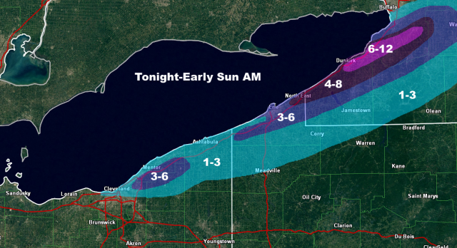
For the map and changes to it, focused the 6-12” corridor in NY where they’ll see the best potential snow tonight and also where the band is likely to affect Saturday morning. Removed the 4-8” from anywhere in NE OH as I don’t think they’ll see much if any tonight, and I’m not quite as impressed with the Saturday night snowfall there…but the higher terrain north of 322 from NE Cuyahoga into southern Lake/northern Geauga should still get a good few inches Saturday afternoon and evening. Did expand the 1” into more of northern Cuyahoga County given potential for a relatively intense band to affect that area for a time late Saturday afternoon/early evening. Reduced the area of 4-8” in Erie County PA for similar reasons as in NE OH, and mainly focused it on the NE corner where better banding will graze late tonight through early Saturday afternoon…that’s not to say that someone can’t squeak out locally more than 6” in central or western Erie County PA if a more persistent band sits there later Saturday afternoon or evening, but I don’t have enough evidence to support it in any given spot. Did bump Erie proper into 3-6” since I think they see a brief burst late tonight, get grazed Saturday morning, and get another good burst early to mid-afternoon as the trough pushes through…though that’s admittedly low confidence, and I feel more confident farther up the shore. 1-3” amounts were extended farther SE overall in NW PA and SW NY on the southern edge to give a nod to most guidance, though didn’t go as far as some models due to likely issues with banding getting too far inland.
-
1
-
-
13 minutes ago, NEOH said:
Thanks for the dropping in with a forecast. I'm going to miss these this winter. For us on the southern fringes here's hoping the bands can shift a little further inland. Usually with a "weak" flow the winds have a hard time coming around to more of NW'erly direction. Winds will be rather strong so perhaps that might help. WRF's aren't too bad for 422 on north.
The winds over the lake come around to about 290 which usually is good for down to 422, I’m just worried that the winds inland stay WSW. It could be close for you at least. This morning was definitely a surprise, must’ve come down hard. Actually got a few sleet pellets here with temps in the low 40s so I guess I’m on the board this winter as well!
-
The lake effect Friday night through Saturday night is intriguing, though wind direction may not be great for some of you.
With the synoptic precip Friday morning temp profiles are close to supporting snow...there will be some dynamic cooling as lift is pretty good and the precip will be moderate, so the higher terrain in NE OH and NW PA will probably try to flip to snow for an hour or two...it may be enough to try to start lightly coating grassy surfaces and such...lakeshore probably just sees rain. NW OH a bit colder and better timing so will probably be some grassy accums there to start Friday.
For the lake effect over the weekend, it's honestly more impressive than I initially thought parameter wise, but some questions about the duration and wind direction make it hard to be confident about a lot of snow falling in any given spot. My impression based on the parameters alone is that someone will hit the 6"/12 hour or 8"/24 hour warning criteria, but a band will need to lock in somewhere for that to happen.
The band will start taking shape late Friday evening as winds line up out of the WSW. With an approaching upper-low and extreme instability developing, it will likely be intense...it may graze the Lake, Ashtabula, and Erie lakeshore for a time, but at some point between 1 AM and 5 AM Saturday will lift out over the lake and come inland south of BUF as winds go more SW. The band will likely be mixed before midnight, but after midnight as 850mb temps crash to -10 to -12C by daybreak the band will be all snow/graupel down to the shoreline given its likely intensity. Winds lock in for a few hours Saturday morning, which could allow the band to slow enough to drop substantial amounts on parts of SW NY along the lakeshore and inland into the southern Buffalo suburbs. Instability will be extreme, with equilibrium heights of near 20k feet thanks to hilarious lake-to-500mb differentials of -45C (approaching -48C briefly). Wind speeds will be strong, but when the band is completely parallel to the long axis of the lake that should allow it to be organized enough. Given the instability, large-scale lift with the upper-low, full-lake fetch and strong convergence the band into SW NY will have a lot of lightning and likely contain very high rates...despite the wet snow, over 2" per hour will be possible. Even though the duration is only a few hours, the possibility exists for up to a foot in SW NY if the band locks in Saturday morning. This could graze northeastern Erie County but I suspect if it locks in it does so just up the shore from Erie proper...though they could get grazed for a time late Friday night/early Saturday and see some snow.
The band will swing into most of the primary NW PA and NE OH Snowbelt Saturday afternoon as a surface trough pushes through and brings the winds around to the WNW over the lake. It probably won't sit over the lakeshore for more than an hour or two as the wind shift is fairly sharp and abrupt, but given the likely instability and forcing it could drop a quick inch or two of snow/graupel near the shore. As for how far south the band can push and what kind of amounts it can drop inland, winds on land don’t really back from WSW as the surface high starts building in quickly Saturday evening. With WNW winds over the lake the band can probably get down to about Downtown and then push east across NE Cuyahoga and into northern Geauga, north of 322. It should get into central and southern Ashtabula as well as most of Erie County, but likely struggles to push into Crawford PA. It may maintain this southern extent for a few hours before drifting back north Saturday evening. The upper support quickly departs late Saturday afternoon and the inversion height lowers substantially, so the band intensity will likely be more moderate when it reaches its southernmost point…it could drop a light/slushy accum on the Cuyahoga lakeshore from Downtown points NE and perhaps a quick 1-3” inland in a few hours.
Overnight Saturday night instability does remain sufficient as the ridge builds in and slowly backs winds over land and pushes the lake effect back up the shoreline. With lightening wind speeds and lake to 850mb diffs remaining easily over 20C through the night, it wouldn’t surprise me if a moderate band or two does reorganize from parts of Lake County and perhaps the chimney of Geauga northeast across northern/central Ashtabula County and northern/central Erie County PA, perhaps into Chautauqua County NY as well later in the night. This band won’t be as intense, but will have light winds and good convergence so should be organized and likely won’t move quickly, so it could drop another 2-6” overnight Saturday night into early Sunday where it sets up.
Overall the potential for heaviest snow will be Saturday morning in SW NY and perhaps extreme NE Erie County, and I’m thinking a quick 6-12” with that where the band sets up…shouldn’t have issues accumulating along the lake given temps aloft and the expected intensity. Expecting a quick 1-4” across the primary Snowbelt as the band swings south Saturday afternoon/early evening before lifting back north…in Cuyahoga and Geauga Counties this is likely confined to along/north of 322 as it looks now. I expect another few inches in the northern Snowbelt overnight Saturday night into early Sunday as bands re-organize and slowly drift north as the surface ridge builds in and as enough instability hangs on.
Forgive the crude map, I never had a chance to make a nicer base that included NW PA and up to Buffalo last winter and don't right now either. I will likely adjust this Friday at some point since I'm off and we're getting another monsoonal here tomorrow afternoon/evening, to nail down the SW NY band better and take another look at the Saturday night amounts/placement.

-
2
-
-
My early impression is that this weekend won't do much...the cold shot is brief and winds quickly go back to the SW. It'll be so cold that if a brief period of LES developed it'd accumulate inland, but I don't think there's much potential for a decent amount. Next week's cold shot at this point looks much deeper/slower moving and could feature a west to northwest wind. The lake to air temp differential should be extreme given lake waters still in the 50s and persistent signals for impressive to near record cold with this airmass, so details certainly to be worked out but that could lead to a significant event somewhere between Monday and Wednesday of next week.
-
I'm not really a big fan of accumulations Saturday night into Sunday in NE OH right now...850mb temps are close to supportive and we've had accumulating snow with similar 925mb and 850mb temps before in October, but the lake is unusually warm and it will be a short-fetch event by the time temps get cold enough to start mixing with snow, which will limit band intensity and blow lake-modified air well inland.
It should still be an interesting time Saturday afternoon and evening as explosive instability develops over the lake thanks to 500mb temps of -30 to -32C moving over 16 to 18C waters...there will be a very strong vort and surface trough moving by Saturday late afternoon/early evening with that extremely instability in place with winds shifting from WSW to NNW...there will likely be an organized shore-parallel band that develops and quickly swings south through much of the Snowbelt and the Cleveland area. Surface temps will be in the low 50s when that happens so the p-type will be "rain," but with unusually strong instability over the lake and low freezing levels there will likely be an abundance of small hail/graupel with that activity. Any stronger cells could probably get close to producing severe criteria hail near the lakeshore given over 1500 J/KG of lake-induced CAPE with a conservative water temp in BUFKIT. Also could be stronger than normal waterspouts over the lake along the surface trough.
As exciting as that is it isn't really snow...the inversion height gradually lowers Saturday evening as we lose the synoptic support with winds becoming well-aligned out of the NNW. Many areas will turn dry but two or three bands will likely occur downwind of the lake between Sandusky and SW NY. It will probably take until at least midnight for the bands to change to all snow even inland...they'll still be fairly intense for a few hours at that point and could be moderate until early Sunday, but again they're multi-bands and likely won't firehose anyone spot and surface temps will be marginal. If any stronger band impacts the higher terrain just right a localized light accumulation could occur, but I think that'll be the exception.
Still, fairly fun for the middle of October.
-
6 hours ago, NEOH said:
Definitely a good opportunity for our 1st LES of the season. CLE is onboard... if temps are that cold I wouldn't rule out accumulations. I think 850 temps were similar during the October 2013 LES snow which caused a lot of tree damage locally.
850 mb temperatures are progged to drop to between - 6 and -8 C across the area over the weekend supporting instability
over the lake. Unfortunately, this means lake effect rain showers and even potential for some snow showers in the traditional primary
snowbelt will develop in the wake of the cold front.  Any accumulations will take place in the higher elevations at this time.
Yeah -6 to -8C would do the trick with an organized band...some runs have shown that, some haven’t, but can’t totally rule it out. As is usually the case with any early events instability won’t be in short supply.
-
I won’t be in Ohio often, but will be next weekend...in Athens Friday/Saturday and in NE Ohio on Sunday. The models have been consistently showing a strong enough cold shot to get some lake effect/instability showers mixed with graupel or wet snow on Sunday...a little ways out from locking it in but the potential for some non-accumulating wintry precip on Sunday seems legitimate and I am rooting it on, since it may be a little longer before I see it out here.
-
20% POPs were ok the last two days IMO...mayybe could've gone 30 or 40% in the Snowbelt where the combination of the lake breeze and terrain can help spark a few more storms, but the areal coverage everywhere except for the Snowbelt was very low. Today's cell ended up being relatively impressive and was slow moving over the eastern suburbs into Geauga, though it really was just the one big cell in that area.
Flood advisories and warnings are tough...it is pretty pointless when they throw them up as the rain is ending which happens more than it should, but you also don't want to issue them and have nothing happen. Some minor poor-drainage flooding is not worthy of an advisory, but if you have enough that you have 6" or 12" of standing water on more than a couple of roads it needs something. Not sure how bad today's was in your area. When I'm contacting our clients for flood-related concerns it's really a fine balancing act between getting ahold of them after flooding is already ongoing and doing it too early when there's a high bust potential...unless it's nearly a slam dunk (solid area of slow-moving very heavy rain moving over a sensitive area) they're going to get some rain before they get contacted, although I try my hardest to do it somewhat before they hit whatever threshold I determine that I think they'll start flooding at. The NWS is issuing for a totally different audience but does ultimately have similar concerns when issuing products like that. 1.13" isn't a minor amount, but unless the ground is already saturated with streams and creeks near bankful it is hard to get substantial flooding with that amount in an area like Chagrin that's not extremely urban.
-
5 hours ago, buckeye said:
I just saw this. Noooooo! You've left us! Ugh Ohio is back to having no pro met representation on the board, ( kind of crazy when you think about it).
Anyways, good luck to you and belated congrats!
Thanks! The downside to this field definitely is way more grads than jobs and a fairly high likelihood of having to move off the bat. Ohio is not rich in met jobs...two NWS offices that you likely won’t get into without a masters or years of experience, and AEP which is almost the same thing. I don’t count broadcast jobs because that’s a whole other beast that I had no interest in touching.
I’ll certainly try to peak in this winter. I won’t work 168 hours a week, hopefully.
-
On 8/22/2018 at 1:58 PM, HO1088 said:
KCGF 221619Z 31015KT 10SM BKN020 BKN040 21/16 A2995+FC(funnel cloud-tornado) RMK +FC(funnel cloud-tornado) E1619 MOVD E
KCGF 221556Z 31015KT 10SM BKN017 BKN030 21/16 A2996+FC(funnel cloud-tornado) RMK +FC(funnel cloud-tornado) B1556 6NE MOV NEWonder if that was the waterspout reported off of Willowick around noon that day...always a fun METAR.
Anyways, it just dawned on me with the lake effect showers and waterspouts this week that as we approach September, lake effect season is just about upon us (of course, it'll be rain for the next several weeks if there is any). With moving to Jersey and starting the job in July this summer has flown by for me. Luckily most of the East Coast doesn't really get wintry threats quite as early as the Great Lakes can.
-
22 hours ago, Hoosier said:
Congrats on the job. Sucks that another poster is moving out of the region though.
9 hours ago, NEOH said:Congrats on the new job! Sorry to hear that you will be leaving. I always look forward to your forecasts and input throughout the Winter. As DTA mentioned, we had over 100" of snow out this way so no complaints. We made a late rally which changed things dramatically.
Good luck with the new job and take care!
Thanks guys! I’m sure I’ll still check in on occasion. I’ll miss the lake effect.
-
5 hours ago, Hoosier said:
Congrats on the job. Sucks that another poster is moving out of the region though.
Thanks. It is bitter sweet for sure, for a number of reasons. I’m happy to get a job in the field, this one seems like a good fit for me, I’m not a big fan of moving away but ultimately I have more reasons to take the job than not...a lack of met jobs that you can get into right out of college around here is a big reason. Either way, I’m sure I’ll still drop in at times as time permits me to.
-
Just tallied up my spread sheets...a total of 93.5” here this winter here. Certainly not bad, a little above average. Would give this winter a B here, but can see how grades range from A to D across northern OH and NW PA dependent on your exact location. After last winter’s crap fest and spending the previous 4 in SE OH, it was nice.
And, this will be my last winter in NE OH, for a while at least. Will be moving to New Jersey for a meteorology job in July. It will be a reduction in annual snow, but it is in an area that can see big snows from those Nor’Easters and is in the somewhat snowier NW corner of the state which averages an ok amount. Plus, they have clients in the OV/GL (including Cleveland) so I’m sure I’ll check in and live vicariously at times.
-
2
-
-
12 hours ago, SouthBuffaloSteve said:
Well the snow spotters at ERI were just quoted saying they are not measuring snow by the generally accepted guidelines of 4 measurements every 6 hours... measuring in 3 hour intervals during the day when compression is highest then at an 8 hour interval overnight when compression is less. Also they are summing 5 daily measurements instead of the accepted 4. I believe this should make the data unofficial!

.Ugh. Yeah. That’s not good.
-
I’m hoping ERI doesn’t get enough snow tonight to hit 200” on the season. I do believe they’ve gotten 170-180” which is still very impressive, but given obvious measuring issues at times this winter with bad over measures I hope they don’t get the distinction of being the only large city to get a 200” winter.
Northern Ohio Obs/Discussion Part 2
in Lakes/Ohio Valley
Posted
The reason for the sort of SE trend on some models has been due to the polar vortex being focused a bit farther east, making it harder for the southern piece to sneak ahead of the western lobe of it and phase, and also causing more confluence in the height field over the NE and a stronger surface high. The GFS and CMC were faster with the southern piece and still phased, while the Euro, NAM, and UK lagged and didn't phase, hence their less impressive solutions.
Given how strong/pressing the polar vortex is, I'd definitely be worried more about suppression than mixing, that's for sure. The 0z GFS and Canadian inched towards a later phase, but changes were borderline noise level...will be interesting to see if the UK and Euro hold. My initial call for the Cleveland/Akron area would be 5-8" but with some more upside if there's an earlier phase. I think even if it doesn't phase well the over-running snow would be decent (and probably good ratios) so you should see a decent amount up there. Would hate to have to put out a number for Columbus because they really could go either way. Because NW NJ dams cold air well and the airmass to the NE is frigid, any QPF that isn't snow here will be sleet/freezing rain. So I am selfishly hoping for the slightly more suppressed route, as exciting as 1.50"+ QPF as "not snow, not rain" would be.