

OHweather
-
Posts
5,046 -
Joined
-
Last visited
Content Type
Profiles
Blogs
Forums
American Weather
Media Demo
Store
Gallery
Posts posted by OHweather
-
-
The band of "better" snow showers running through Huron, Lorain, Medina, Summit, Portage and Mahoning Counties will be a wild card this evening. It appears to be associated with a weak surface trough and is connected to Lake Michigan. I'm worried that if it stays south this evening that it limits any organization of snow showers of the primary snowbelt in NE OH and NW PA, especially with strong winds also making it harder for bands to organize. It's currently lifting north, slowly, and winds go a little more WSW the next few hours, but then gain a slight northerly component later this evening as the first vort max moves through. Whether or not that band lifts north into the Snowbelt will determine how this evening goes...usually with a W or even WSW wind would expect the surface trough to end up near the lake, but it's starting pretty far south. Based on the intensity of the snow showers the thermodynamic environment is sufficient for heavy snow if a band organizes, but we need a band to organize to see that.
Later tonight the winds do gain more of a southerly component which should push the surface trough north into the primary Snowbelt by morning, so I think either way we see a band flare up east of Cleveland late tonight into Friday morning that's moderate to heavy, but whether or not there's substantial snow this evening is sort of in question.
The setup still looks good for Friday evening through Saturday morning, with deeper moisture and good synoptic support likely making that less touchy than this evening.
-
Last night was on the low end of what I hoped for...not at all a bust, but the initial warm ground, blowing snow, and only a few hours of true good lake enhancement all worked against more than a few inches in the hills (a local 5-6" spot in parts of NW PA). The ongoing snow showers are decent (and under-modeled), but agree they lift north of NEOH and dta tonight as winds go W or even WSW. Erie County PA will snow (and the airport has been snowing decently for a little while), but with a strong flow I do wonder if the immediate shore gets less than progged and snow sets up a bit inland (could certainly see how it's just inland but north of Edinboro tonight, but should shift inland tomorrow night).
-
Here's a map including all snow from this evening (made around 5 PM) through the lake effect that winds down on Saturday...we'll see how it verifies:
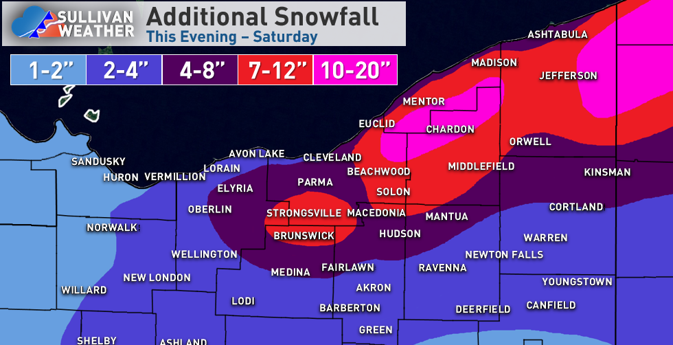
Some reasoning:
My thoughts on tonight haven't changed much...the synoptic snow this evening is not that heavy or efficient, but may drop up to an inch or two in the Cleveland area and east side. Lake enhancement ramps up starting 9 or 10 PM and is most intense about 11 PM - 6 AM east of Cleveland, tapering slightly faster in the Cleveland area and secondary Snowbelt (and lingering past sunrise in NW PA). I still think the duration of the lake enhanced snow and improving ratios will allow for 4-6" in the hills of the secondary Snowbelt by morning (when including the ongoing synoptic snow) and 4-7" for most of the higher terrain east of Cleveland, with 6"+ likely in northern Geauga County and most of interior NW PA. Hi-res models continue to have 0.4-0.5" of QPF as snow in the higher terrain by morning which supports the potential for 6"+ in the most favored hills with improving ratios overnight. Winds ramp up overnight as the ratios improve so it could be a pretty wintry scene by morning. It will likely only be 2 or 3" tonight closer to the lake and in Cleveland proper, dropping off towards Sandusky where most of their snow was from the synoptic snow today with lighter snow from here on out. With a strong NW flow 2"+ totals tonight likely make it down to Mansfield, Akron and near Youngstown.
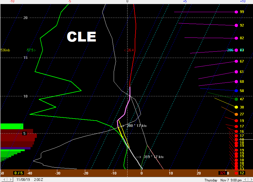
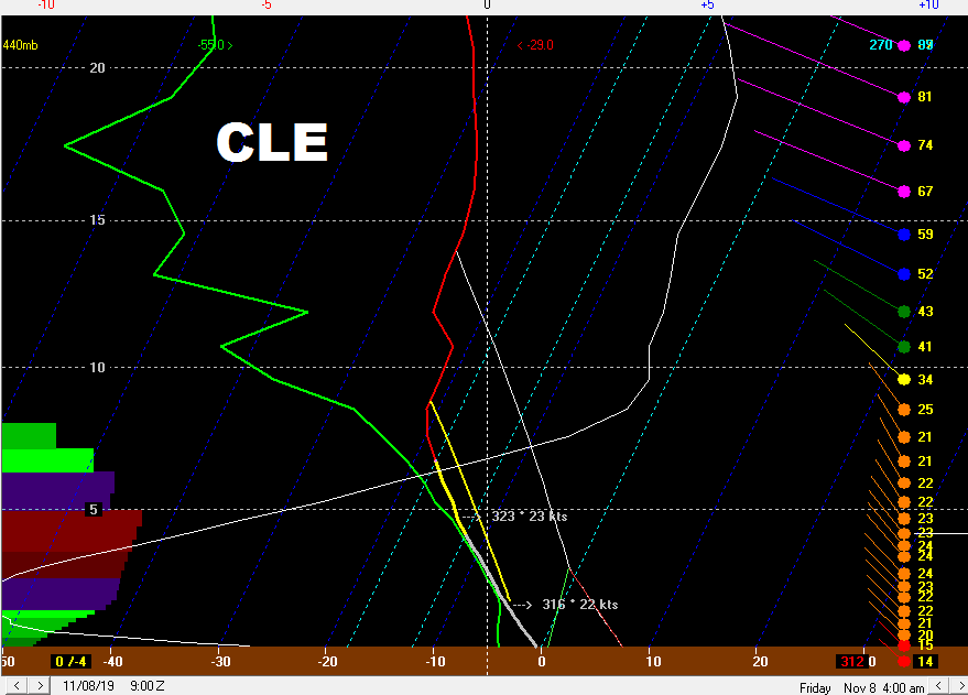
There's likely a bit of a lull Thursday morning, though lake effect conditions become passable in the afternoon. Bands are likely disorganized Thursday afternoon but may drop a Coating to 2" as they go, and may start southwest of Cleveland and in the secondary Snowbelt before shifting into the primary Snowbelt towards evening. Thursday evening through Friday morning is interesting as a surface trough and vort max move through slowly, adding lift. The edge of the better synoptic moisture just grazes NE Ohio, though with a long fetch and some Lake Michigan moisture should be sufficient. Although instability and moisture both are marginal to moderate, they are well focused in the DGZ Thursday night into Friday morning, so ratios will be good. In terms of band placement, NAM guidance has a band well southwest of Cleveland Thursday evening but the RGEM lifts it into the primary Snowbelt quicker...given the westerly flow, I heavily favor the RGEM, with a few W-E oriented bands ikely from northeast Cuyahoga, Geauga and Lake through NW PA and SW NY. Given the good ratios, long fetch, and synoptic lift for a pretty long period of time I expect these bands to drop 3-6 or 4-8" type amounts Thursday evening through Friday morning on parts of the primary NE Ohio Snowbelt into NW PA and SW NY. There will be little south of Cleveland, though some snow showers and the synoptic lift could produce a local coating to 1" in the rest of NE Ohio in this window (though nothing organized outside of the primary Snowbelt).
There's likely a relative lull later Friday morning into the afternoon, before a fairly deep lobe of synoptic moisture and embedded shortwave drop across Lake Erie Friday night into Saturday morning. As winds slowly shift from W to NW over the lake convergence will increase over the Snowbelt and there will be some upslope, with snow spreading south into the Cleveland area and eventually perhaps the secondary Snowbelt south of Cleveland again. Ratios again look high with a decent amount of moisture and some synoptic lift, so I think another few to locally several inches can occur Friday night into Saturday, most in the higher terrain east of Cleveland into NW PA and SW NY, but also with some snow for the Cleveland area and secondary Snowbelt.
Given the multiple windows for snow and ratios, I think a widespread 10"+ is likely for the hills in the primary NE Ohio Snowbelt into NW PA, with 15-20" where bands are especially persistent. The Cleveland area and lakeshore will see less, but occasional periods of snow will gradually add up some. The secondary Snowbelt I'm debating if I went a bit too high, but if they get a few inches tonight, a little bit Thursday afternoon, and a couple inches or so Friday night into Saturday can squeak out the low end. Most of the snow west of Lorain and south of Medina, Akron and Youngstown will fall tonight, though they may see some snow showers at times Thursday through Saturday that can add additional light amounts.
-
 2
2
-
-
Suppose I should post this before it starts snowing...
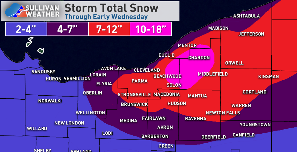
With the 850mb low track still near or just west of Sandusky into western Lake Erie, expect the heaviest synoptic snows to fall in NW Ohio. There, a long duration light snow from tonight (Tuesday night) through Wednesday evening, along with a period of moderate snow Wednesday afternoon when some modest fgen and deform ramp up will likely lead to a widespread 4 to locally 7". The rain/snow line will slowly progress southeast during the day, with the west side changing over by early-mid afternoon, and Cleveland and the Snowbelt late-afternoon or early evening.
In north-central and NE Ohio there will be less synoptic snow as the weak deform band quickly swings through, thinking the synoptic snow is 1-2 or 3" in Cleveland/Akron and 2-4" on the west side...generally, the synoptic snow will be heavier closer to the lake as the best lift passes to the north. I do like the lake enhanced setup...temperatures get cold enough for lake enhancement from west to east between 8-10 PM and are quite optimal for several hours overnight with a NW flow backing towards WNW, with 700mb moisture not stripping away Cleveland points east until close to sunrise Thursday. Usually when the lake induced instability gets above the -10C level (which occurs late-evening) there will be moderate to heavy orographic lift snow in these setups in the terrain downwind of the lake until the 700mb moisture strips away. This gives a prolonged window from late evening through around sunrise Thursday of good lake enhanced snow east of Cleveland (tapers off slightly quicker south of Cleveland).
My general rules of thumb in these lake enhanced scenarios (when it's cold enough, which it will be by late evening) are to take the highest QPF and assume at least a 15:1 ratio. Some hi-res models have up to half an inch of QPF as lake enhanced snow through Thursday morning, which yields potentially over half a foot. Another rule is that once it gets cold enough that rates in the higher terrain will be generally 0.5-1" per hour until the 700mb moisture strips away...given the duration (on top of the light synoptic snow in the early-mid evening) this also suggests over half a foot of lake enhancement in the prone spots.
I'd like to see the hi-res stuff just a little juicier for widespread 6"+ totals, but think anyone in the hills south or east of Cleveland gets 4-7", with 6"+ being likely in the highest terrain of Geauga (and also NW PA) through Thursday morning. With wind gusts of 25-35 mph and an increasingly fluffy snow overnight, there will be blowing and drifting snow and it will be quite wintry by Thursday morning. There will be much less lake enhanced snow near the lakeshore and I'd expect the immediate lakeshore to come in on the low ends of the ranges across the board...worried about the western lakeshore missing the better synoptic snow to the west and better lake enhanced snow to to the east, so we'll see if those 4" totals can be met in northern Erie County. Otherwise, I think the terrain does fine.
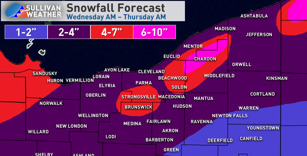
In terms of the additional lake effect, conditions quickly become favorable for traditional lake effect Thursday morning and afternoon, though winds go westerly (maybe even slightly S of W at times) by late Thursday through the day Friday. The lake effect will likely be moderate and accumulate efficiently Thursday afternoon into Friday morning with a long fetch and little shear, good lift and moisture in the DGZ, good synoptic support from a vort max rotating around the closed low to our northeast, and the edge of the synoptic moisture grazing Lake Erie...but, I think the heaviest snows in this period are focused near or just north of the 322 corridor in the northern Snowbelt into NW PA with a more westerly flow. Given the duration of this setup and likely high ratios, where bands persist could see another 6-10" of snow Thursday afternoon through Friday morning.
There may be a lull Friday afternoon as we briefly get into some synoptic-scale sinking motion, but conditions become favorable again Friday night into Saturday morning. A lobe of deep moisture and a good vort max move through, with winds slowly shifting from W to NW. I think this is more of a lake enhanced setup with weaker instability but abundant moisture and some lift, but good snow growth given the temperature profiles. Winds will favor broad convergence over the Cleveland area and Snowbelt which will help focus snow, and orographic lift will help too. Given the decent duration and likely good ratios, this likely supports another 4-8" type accumulation from eastern Cuyahoga County into southern Lake, most of Geauga, inland Ashtabula and the higher terrain in NW PA Friday night into Saturday morning. Some accumulations likely get into the secondary Snowbelt south of Cleveland by Saturday morning as winds go more NW.
The lake effect likely winds down on Saturday as ridging builds in...time permitting I'll post a map for just the lake effect Thursday afternoon-Saturday on Wednesday.
-
3
-
-
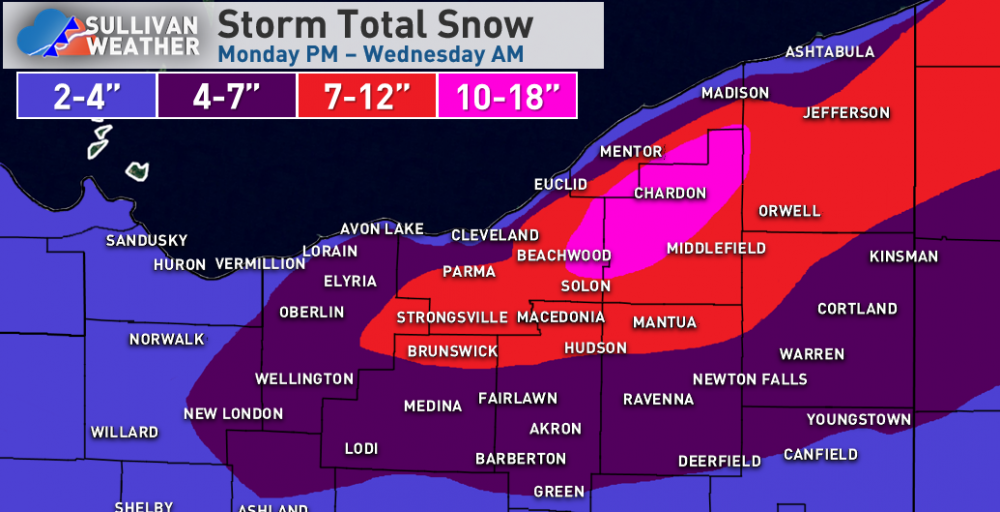
Definitely an interesting few days coming up (if you want snow still)
The wrap around/lake enhanced snow Wednesday night looks like a general 1-3" for the Cleveland area, but could see 2-4 or 3-6" in the higher terrain due to lake enhancement. NW OH likely sees heavier synoptic snow as it looks.
There will be off an on lake effect Thursday afternoon through Sunday morning...the flow through Friday may be pretty westerly or even WSW at times, but Friday night into the weekend we will see a more WNW or even NW flow. Instability looks sufficient with a lot of moisture, so there should be enough additional lake effect for advisories and maybe even some warnings late Thursday into the weekend...though as always we'll need to watch the wind direction.
-
This is almost like a "normal" stretch of snow for you guys these last couple of weeks, even if there hasn't been a huge storm to catch you up on your seasonal totals. Tonight isn't a great setup, but it'll snow decently when the front goes through this evening with some lake effect tonight...I agree with 2-4" probably for most of the snowbelt and even Cleveland area.
-
Thundersnow! Too bad the band lifted north of you two so quickly.
-
1
-
-
Definitely seems like a nice little event through the day today. I'm pretty intrigued by what happens through the evening and into the overnight, conditions are nearly ideal for very efficient snow growth and as the sun sets it will accumulate even better than it already is, with ratios probably exceeding 20:1 tonight. With a vort max over southern lower MI moving east across Lake Erie and extreme NE OH/NW PA this evening into tonight and the flow backing, increasing the fetch and also increasing convergence over the Snowbelt, I still think a few more inches could be squeezed out where bands are most persistent from the Cleveland area points east...with possibly as much as 6" in NW PA. Soundings remain OK into Saturday, so it may snow in northern Erie County into the morning before lifting out over the lake or into extreme SW NY.
-
The NAM being too amped on the synoptic snow didn’t help, but also isn’t very surprising, which takes away the potential for a very nice event.
I still think 4-7” is doable for much of the higher terrain in eastern Cuyahoga County and Geauga County into NW PA...the synoptic snow on its own likely produces 1-2” through mid morning tomorrow, with several hours of light to perhaps moderate lake enhanced snow late morning through mid afternoon, with a Lake Huron connection swinging west to east across the Cleveland area and Snowbelt during that window. I think that period drops another 1-2, locally 3” from mid morning through mid afternoon, focused on the higher terrain. Lake effect conditions are fair Friday evening and night...although instability isn’t extreme and EL heights are 8-9k feet which is a bit modest, steep lapse rates and moisture through the snow growth zone, weak shear, and increasing convergence near the lakeshore may keep moderate bands going through the night. They will gradually move and overall shift north by Saturday morning, but I could see Friday evening and night dropping another 1 to locally 4” in the primary Snowbelt. It does add up to several inches in the higher terrain, mainly owing to the duration and increasing ratios. Not a great storm, but it will have to suffice this winter...
-
4
-
-
Thursday night into Friday could be interesting for you guys...models trending a little stronger with the low pulling away to the east and throwing back some synoptic snow Thursday night into Friday morning, with lake enhanced snow continuing through the day Friday and some traditional lake effect Friday night. Assuming the synoptic snow can produce even 1-3 or 2-4", the added lake help could push widespread 6"+ totals in the higher terrain of the primary and secondary belts...could even see a run at double digits if the NAM is onto something with a solid several inches of synoptic snow.
-
1
-
 1
1
-
-
The secondary Snowbelt has gotten crushed this evening...CLE has been reporting 1”/hour snow rates the last two hours with ratios of 50:1 if the liquid catch is accurate!
KCLE 200451Z 24007KT 3/4SM -SN BR VV011 M07/M09 A3034 RMK AO2 SLP288 SNINCR 1/4 P0002 T10671089 400001089
-
I'm going to be in NE Ohio for a few days, and am excited to at least see some flakes Wednesday night. I doubt I'll see much in northern Summit County (maybe a dusting), but it's a pretty moist upslope setup so the higher terrain in Geauga could certainly squeak out 2-4". It's marginal temperature wise and not that intense so the lower elevations will probably struggle mightily.
-
Some big totals coming in from Geauga and Ashtabula. A lot of areas at 10-15” so far adding the reports together. We’ll see how things fill in report wise farther west. Glad you guys both got into the double digits!
-
It seems like the shear kept bands a little bit too disorganized to really add up in any one spot (except for parts of Ashtabula County into western Crawford County who are getting crushed). There should be another flare-up in a few hours as winds turn more WNW and we get some Lake Michigan moisture, but it's likely fairly modest...maybe another 1-3" in spots.
Edit: a couple of reports ranging from 8-11” near Wellington in Lorain County for the surprise of the storm so far.
-
Looks like everyone did well enough last night that the low ends will be hit most areas without too much effort today...we'll see if there's persistent enough banding anywhere for some spot to hit the high end of my evergreen aggressive ranges.
-
1
-
-
A few quick thoughts...
Looks like everyone except the immediate lakeshore (including Cleveland proper) and CAK to YNG is over to decent snow, with the Chardon cam looking like between 1-2" already. I think the idea of 1-2" lakeshore/lower elevations and 2-4" in the hills in northeast/north-central OH for the synoptic snow is just fine. CAK to YNG will come in closer to an inch or two of synoptic snow that far south.
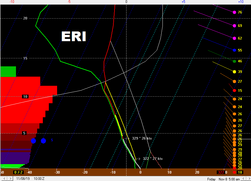
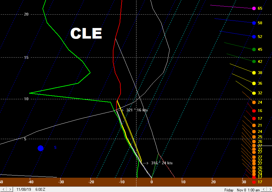
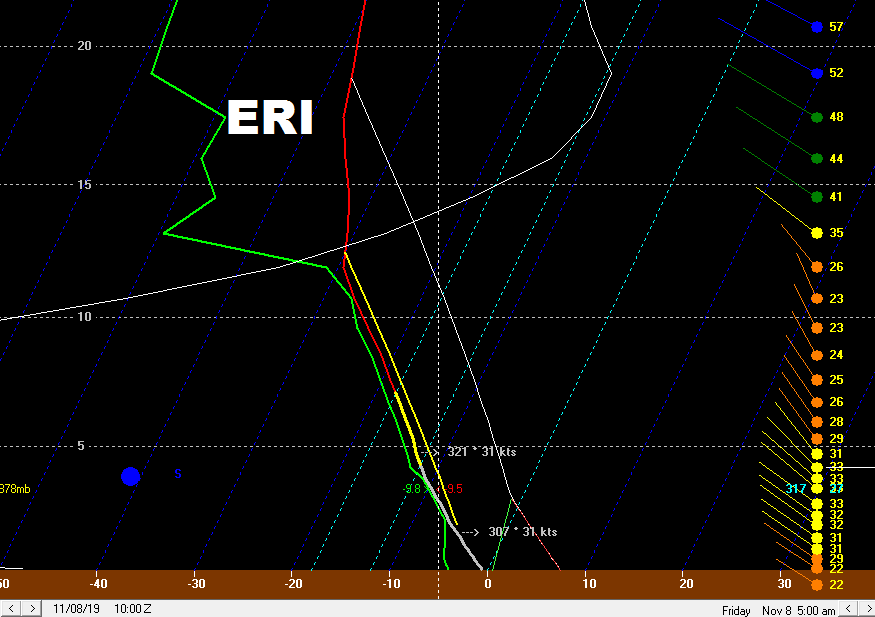
As for the lake effect, I'll attach a few images to go with this. But it's an impressive synoptic setup with extreme instability and very deep moisture. The only small fly in the ointment is some shear and gradually shifting winds, though I think the overwhelming positives will still result in fairly widespread heavy amounts.
The thermodynamics and moisture become outstanding at CLE and ERI (CLE shown) tomorrow morning with extreme instability, very high EL heights, deep moisture to over 10k feet and instability and lift focused in the snow growth zone. The profiles remain outstanding through the afternoon before inversions and moisture depth gradually come down through Tuesday night, though even through Tuesday night the lift and instability are well-placed in the snow growth zone, so any bands would be efficient. There is moderate shear through most of the day tomorrow before the flow becomes better aligned tomorrow evening through early Wednesday, though the somewhat weaker flow may help offset the shear a little bit.
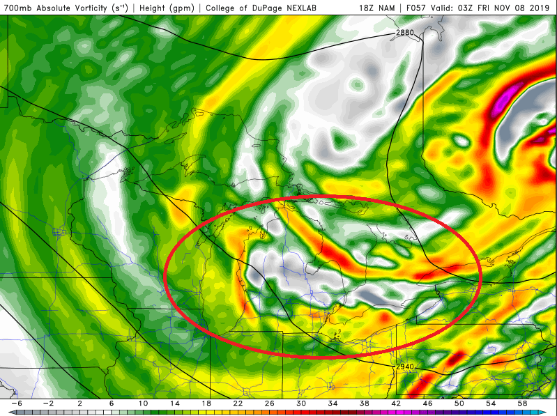
So, synoptically there's a lot going on...we have multiple vorts moving through along with a large plume of 700mb moisture that is overhead for several hours Tuesday morning and early afternoon...
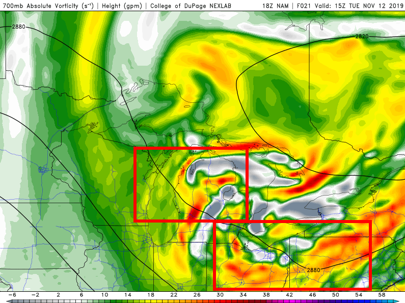
We do gradually lose synoptic support and deeper moisture Tuesday evening as the vorts move east.
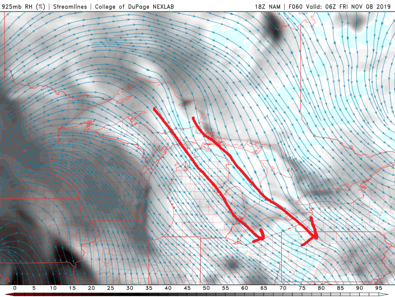
Lower down, there's good agreement on a trough extending across NE Ohio for much of the day (it's already developing) along with multiple upstream connections, including from Lake Huron:
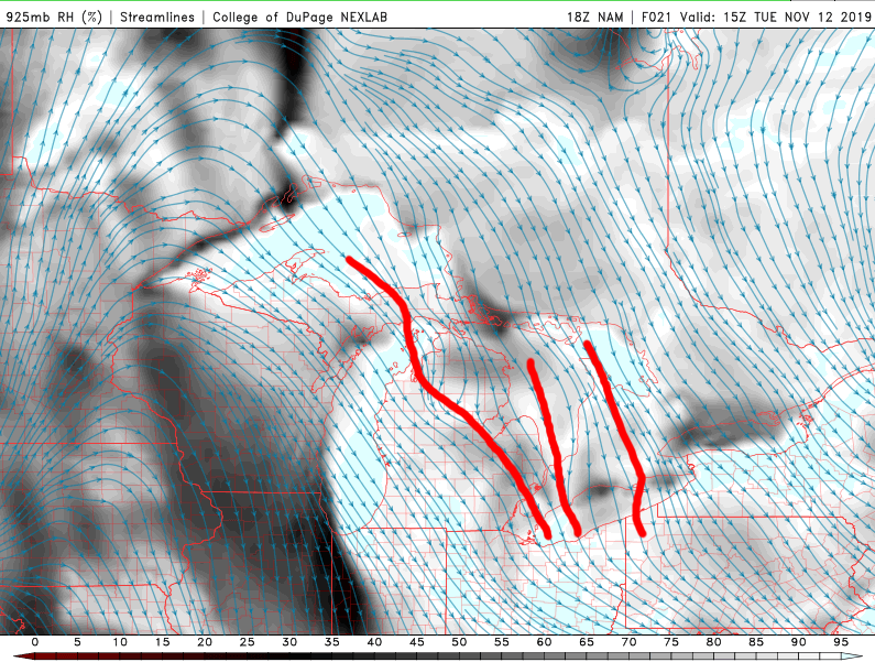
This should focus a broad area of enhanced snow showers with a few heavier bands where upstream connections occur, and also decent terrain enhancement given the moist NW flow hitting the terrain all day. This seems to favor NE Ohio for heavier snow than NW PA through most of Tuesday, though as winds shift more westerly late Tuesday better snow will shift east into NW PA (they'll likely see decent snow showers before the "better" snow shifts east into there later in the day).
Tuesday night inversion heights and moisture depth come down, but convergence will increase over the Snowbelt as ridging builds overland and winds turn more W or WNW...there will also be one last shot of Lake Michigan moisture. While banding won't be as intense, light to moderate bands with efficient snow may linger through much of the night east of CLE and through NW PA/SW NY.
Given a long duration of very favorable conditions late tonight through Tuesday afternoon and enough juice for some banding through Tuesday night, I remain aggressive with the lake effect forecast. This map includes the 1-2/2-4" synoptic snow falling now. The Huron band may go into the eastern suburbs or Geauga County for several hours which would bode well for the bullseye in that area...if this band occurs and sits anywhere totals will easily exceed a foot for the whole event. It feels odd forecasting this much for a shorter fetch event with winds moving around some, but I think the positives are rather overwhelming...as always, we'll see.
-
1
-
 1
1
-
-
CLE didn’t have accumulating snow in until 7pm so I’m not quite sure what their concern is (I also think they’re conservative on the LES so losing an inch of synoptic doesn’t hurt much). I think it’s all fairly on track, models all kept it pretty warm downwind of the lake until rates really ramp up after 5-6pm at which point the higher terrain should start to flip quickly...lakeshore may take until 8pm.
-
1 hour ago, vpbob21 said:
Great analysis OHweather, as always.
I mentioned in the main thread that I just find it hilarious that Ottawa/Sandusky/Seneca/Erie/Huron/Lorain/Medina counties are the missing link in an otherwise unbroken string of winter headlines that runs from Montana to Maine. I guess I can't really blame them for not wanting to pull the trigger, knowing how bad our snow climo is around here. I do think some of the counties left out of headlines will eventually be added, especially Lorain and Medina (perhaps even warnings there) and probably the inland counties of Huron, Sandusky and Seneca. The lakeshore counties might be a little more borderline with the warm lake temps cutting into accumulations, but at the least it looks like everyone should get on the scoreboard for the season.
Yeah, your area is unfortunate for snow lovers for a few reasons. But, everyone should get something at least, which isn’t too bad for this early. I do suspect advisories fill in for the rest of Ohio tomorrow due to the falling temperatures and icy roads along with the snow even if not everyone is hitting the advisory criteria. My guess is near you right by the lake struggles to get 2” due to the warmth you mentioned but inland will do better.
-
I may or may not have time to post a more technical discussion tonight or tomorrow, but here's the map I posted on FB:
The thinking is 1-2" of synoptic snow near the lake and 2-4" inland, highest in the hills. Temperatures marginal during the synoptic snow in the Cleveland area so hills should do better as they'll be colder and also have some orographic lift to enhance the snow. Then the rest of the is lake effect.
Parameters are very good, with a prolonged period of extreme instability and much better moisture than the last event. The flow is also fairly light and well aligned with decent synoptic support in a cyclonic flow under an upper-level trough. The temperature profile is ideal for high ratios with the lake effect. Question is band placement and persistence.
Winds swing NNE to NW late Monday night through Tuesday morning which should swing a Huron band from west of Cleveland east across the primary snowbelt, possibly getting into NW PA during the afternoon. Outside of this band, favorable parameters should allow decent orographic lift snow showers to allow for continued slower accumulations, especially in the hills. Both the NAM and RGEM show a vort max and surface trough dropping through late Tuesday afternoon or evening that may focus a more organized convergence band near Cleveland east into the snowbelt. This band may linger through most of Tuesday night as ridging builds south of the lake and turns winds more SW over land, with the snow eventually lifting NE and weakening by Wednesday morning. Any bands early Tuesday through Tuesday night can produce 1-2" per hour rates in their core and perhaps some thundersnow.
The secondary snowbelt in southern Cuyahoga/northern Medina is odd...should get 2-4" of synoptic snow, another 1-3 or 2-4" through Tuesday AM as the Huron band swings east with orographic lift outside of it, and then not sure if the possible convergence band Tuesday evening/night sets up there or a little father north. Either way they should get several inches and could get 8"+ if they get the convergence band later Tuesday/Tuesday night.
For eastern Cuyahoga and Geauga, thinking 2-4" of synoptic snow, another 2-4" or so through Tuesday AM, perhaps up to 6" if the Huron band is slow enough, and then likely at least several more inches where the convergence band sets up later Tuesday into Tuesday night. Either way, I think that higher terrain gets widespread double digits with well over a foot if / where the convergence band develops and is persistent.
Into NW PA, similar synoptic story, perhaps a tad more in the higher terrain, the Huron band may swing east into there and allow for beefier totals too, and even outside of that there will be some orographic lift. Think widespread 8"+ is likely in the higher terrain in southern Erie and northern Crawford Counties..
Let it snow!
-
2
-
-
Here’s another link to the PNS.
Some 2-4” reports down into Portage and Trumbull Counties even. Hopefully the next event can spread the wealth some more!
-
That radar loop is very unfortunate for your area for sure

-
Looks like it's snowing pretty good away from the immediate lake, and the Chardon cam has covered the ground! Hoping for a flurry here in NW NJ tomorrow morning.
-
1
-
-
^That CMC depiction looks like some convective feedback, but it's pretty cool to imagine. Definitely looks like some decent snow potential early next week, both with a wave moving by along the front Monday into Tuesday and with lake effect. Winds likely have a decent northerly component for a time so it shouldn't all go into Buffalo.
As for the event Thursday-Friday, some detailed thoughts...
First, the maps…the nice one I posted on my FB page:
 I don’t have a nicer template that includes all of NW PA, but here’s a rough sketch:
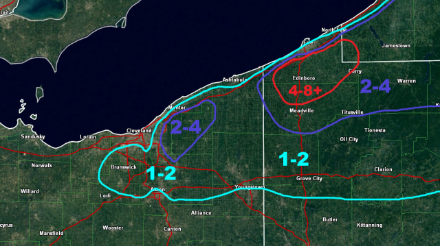
And now an overly detailed analysis…
Synoptic rain / snow late Thursday morning/afternoon…
The back edge of a budding ana-frontal rain shield will mix with and change to snow across parts of central and northern Ohio on Thursday as colder air filters in. This precip shield will be very progressive and only the back edge has a chance to briefly change to snow as the colder air catches it, so accumulations generally aren’t likely. A few of the hills in north-central Ohio could see a coating on grassy and elevated surfaces.
The forecast soundings for CLE and ERI actually aren’t bad with some signs of lake enhancement early in the afternoon, but it’s warm. There’s moderate lift co-located with the snow growth zone and a respectably deep layer of lake-induced instability, with northerly winds that will hit the terrain south and east of Cleveland, along with in NW PA and SW NY well. The issue is boundary layer temperatures in the lower elevations will be in the mid to upper 30s, so despite 925mb temps of -1 to -2C in this time period accumulating snow won’t occur in the low elevations (and along the lake it may stay rain). The hills south of Cleveland may see a dusting and there could be up to an inch in the highest hills of Geauga County (and perhaps a dusting as far west as the heights suburbs). The higher elevations of NW PA could see a quick, wet inch of snow with up to 2” in the higher elevations of SW NY as there’s more terrain and the precip shield is better-developed by then. Again, no daytime accumulations in the lower elevations.
Lake effect Thursday night through Friday…
As a very deep cold airmass moves over Lake Erie Thursday night into Friday extreme instability will develop with a generally northwest flow. The airmass is fairly dry and ridging starts building in from the west Friday morning making this a short-duration window for lake effect (especially in Ohio), so any decent accumulations will depend on any synoptic moisture / lift and upstream lake connections.
There will be a few hour period in the evening behind the synoptic rain / snow when there’s little synoptic help and before any upstream connections establish. There’s still moderate instability on the sounding and the winds in the lowest 5k feet are well-aligned, though the sounding is somewhat dry with a short fetch. There will likely be snow showers in the early evening in this environment, especially in the higher terrain where there’s an orographic assist, but they won’t be organized and any initial accumulations won’t be especially good.
We do get a shot of synoptic help with a decent vort max that moves over the lake from late evening into the overnight, moving east into Friday morning. This adds some upward motion over the entire lake and does bring a brief shot of synoptic moisture, especially to the eastern half or so of the lake (extreme NE OH points east).
CLE’s sounding improves as this vort moves overhead, with instability becoming extreme and moisture depth up to about 7k feet. The flow is also moderate and fairly well aligned (a bit of shear but could be worse). This may support a more widespread burst of snow with the vort max, along with locally heavy snow under any upstream connections that develop into NE Ohio.
Erie’s sounding has even deeper moisture and instability, along with little shear beneath 10k feet. This would support lightning with any more intense snow bands and greater than 2” per hour snow rates…NW PA also has more terrain to work with than NE Ohio and has a stronger upstream connection to a close-by Lake Huron.

The Lake Huron connection may start fairly far west Friday evening as winds behind the developing wave of low pressure will be north, but should quickly swing into the eastern half of Erie County or even extreme SW Chautauqua County NY ahead of the vort max before going back into more of Erie County towards early Friday. The classic NW flow connection from just east of Marquette to near Traverse City to Lake Erie likely goes into the eastern suburbs of Geauga County ahead of the vort max with a slightly W of NW wind (growing up in Solon that’s where that connection goes with a 305ish flow)…it may back west a bit into early Friday behind the vort as winds veer a little more. There may be another connection from Lake Michigan west of Cleveland but is likely less organized. These will be the connections to watch for the best accumulations…how stationary they are or aren’t will be important to how high the highest localized totals are…the Lake Huron one is most interesting as it’s obviously the closest connection and also has deeper synoptic moisture than the NE Ohio ones will.
Ridging builds in quickly towards Friday morning and by 10 AM, the Cleveland sounding is pretty dry. With a lake induced EL still over 10k feet and a well-aligned flow there may be some lingering light to moderate snow showers with any left-over band that’s drifting around the metro or Snowbelt south or east of Cleveland, but it likely won’t be organized or accumulate all that much more by this point.
Erie’s soundings still remain very impressive through the morning and half decent into the evening, so the Lake Huron connection (which may briefly drift into Ashtabula County around noon Friday before swinging back east) could still rip pretty well into Friday afternoon. While the inversion heights and moisture finally start diminishing through the afternoon, there’s moderate instability and a reasonably well aligned flow through the evening, so as the winds go W and then SW Friday evening there may be one last flareup over NW PA that quickly lifts up the lakeshore but drops a little bit more snow as it goes.
Thoughts on band evolution and accumulation from the lake effect…
There’s likely an uptick late evening as the vort approaches over NE Ohio and NW PA. Upstream connections will be important and eastern Erie County PA/Chautauqua County NY, along with eastern Cuyahoga/Geauga in Ohio (and perhaps a weak one southwest of Cleveland) may be hot spots.

As the vort moves through it brings a subtle surface trough that may bring a more general burst of snow from Lorain and Medina Counties points east given extreme instability and enough moisture after midnight. With winds briefly going close to WNW ahead of it, it’s possible a more organized west-northwest to east-southeast oriented band briefly develops over Cuyahoga and Geauga Counties and then swings southwest into parts of Lorain, Medina and Summit Counties as the vort moves through and pushes the surface trough south. This may coincide with the upstream connection into the east side of Cleveland. The Lake Huron band will likely swing west into much more of Erie County PA as the vort passes overnight Thursday night into early Friday.
Behind the vort into Friday morning winds don’t move much for a few hours, so the lingering convergent band into the Secondary NE Ohio Snowbelt (parts of Lorain / Medina / Summit) may last into the morning in some form, and the upstream connection into the eastern suburbs also lasts into the early morning. The big show will be the Lake Huron band in NW PA that should go straight into the morning.
Winds do go more northerly Friday morning as the flow turns anti-cyclonic. This should end any substantial snow in the Cleveland area, though whatever is left of the bands that establish overnight may continue to drift west and produce snow showers that might drop very light amounts through Friday morning. This likely brings the Lake Huron connection briefly into Ashtabula County (and it should still be moderate to heavy) before it slowly swings back east Friday afternoon and evening across NW PA and into SW NY as winds slowly back to the W and then SW. As it swings east enough instability remains for it to drop a little more snow as it goes.
For daytime Thursday accums I’m assuming little to none except for the highest hills in northern Geauga that could see an inch…along with inland NW PA and SW NY that could see an inch or two above 1000 feet.
In NW PA I except any Lake Huron connection to have 1-2”+ per hour snow rates from late evening through Friday morning, a period of 12-15 hours. With that said, it likely is gradually moving most of the time so areas may only be under it for a couple of hours at a time. Outside of the connection, the soundings do support snow showers due to orographic lift for about the same period which will keep accums going, albeit at a slower pace, in the hills outside of the narrower heavy band. Ratios will become high away from the lake as well which will help with accumulations. There could be a quick dusting to 2” Friday afternoon or evening as the remnant band lifts back up the shore. All in all I don’t see how a lot of the higher elevations in NW PA don’t see at least 4-8” of snow, with locally higher possible if the band is at all persistent in any area. My gut says someone gets over 8”, perhaps a foot, but with the band perhaps not locking in it’s hard to explicitly forecast that. Also went 2-4” into eastern Ashtabula where there’s some terrain and where the band may drift into for a time around noon Friday.
In NE Ohio I’m going with a general inch or so away from Lake Erie for the uptick that occurs when the vort max and trough push through. The eastern suburbs into Geauga County I went 2-4”…the thought is with a possible WNW to ESE band developing for a time ahead of the vort max and a likely upstream connection that keeps a narrow band going into Friday morning, along with enough instability for 1” per hour rates under any focused bands, that over 2” is pretty likely. If any banding is more persistent someone may get more than 4”, but I think that’s very localized. The higher hills in northern Geauga may be a little northeast of the banding Thursday night into early Friday but will see some orographic lift snow showers anyways, and could see a light accumulation during the day Thursday, so over 2” seems likely there.
The other interesting spot in NE Ohio is the “Secondary Snowbelt” as the remnant convergent band may sit in that area into Friday morning behind the vort max. There isn’t a well-defined upstream connection into that area, I’m not confident they get any accumulation during the day Thursday, and ridging builds in fairly quickly so I’m not confident many areas get over 2” there, but a few may in the area I outlined.
-
2
-
-
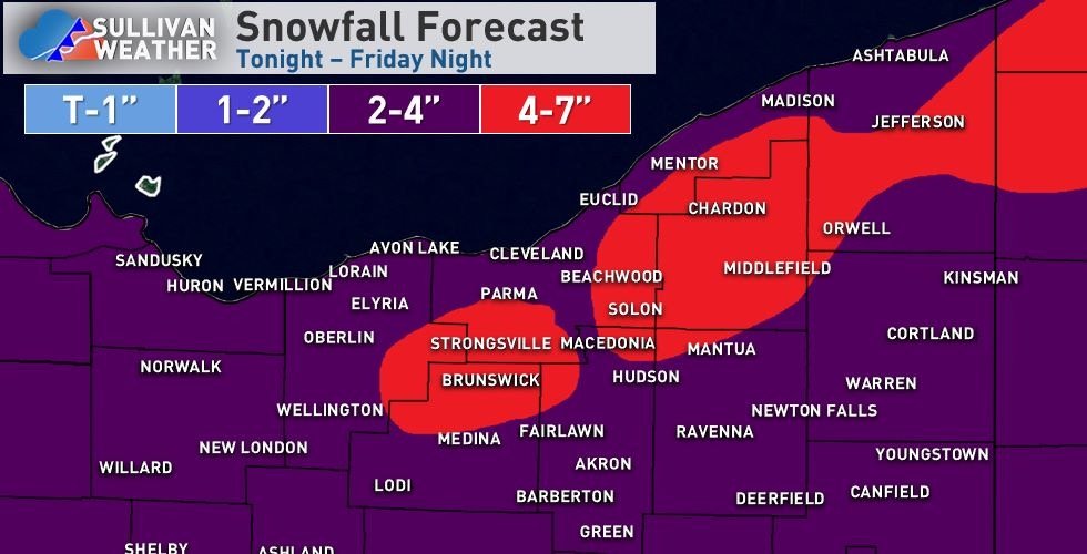
It seems that a brief period of light synoptic snow is fairly likely for most of northern Ohio Thursday afternoon. It probably struggles to stick in most areas, but some hilly areas may see a slushy coating.
As for lake effect, the air coming down at the end of the week is much colder than the airmass we saw last weekend when accumulating snow was mostly confined to the highest terrain in SW NY, however, the fetch is short which adds different complications.
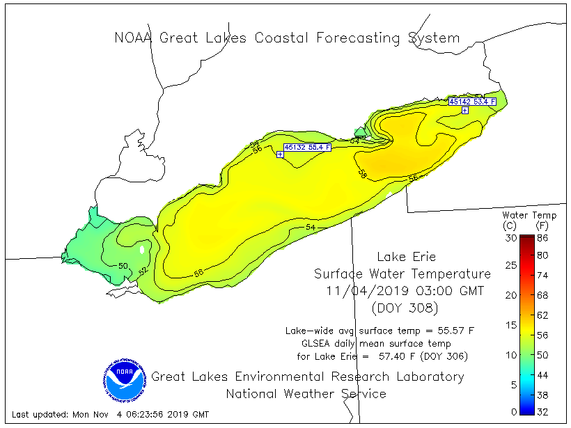
To re-hash the water temps NEOH posted, they're still fairly toasty in areas that we care about for a NW flow event, though the waters over western Lake Erie are into their yearly free-fall...
The airmass Thursday night into Friday features 500mb temps of -32 to -35C (even colder near BUF), a difference of 45C or so over central and eastern Lake Erie. 700mb temps will be -22 to -24C, a 35-38C difference, while even 850mb temps will be -11 to -12C, a 24-26C difference. These values are all extreme. The issue is fetch and how long any lake effect lasts.
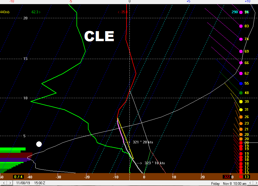
The Cleveland sounding at its peek is perfectly fine, with extreme instability and EL heights over 15k feet, little shear, and moisture depth to almost 10k feet. Unfortunately, this look only lasts a few hours with moisture depth and inversion heights falling quickly towards morning.
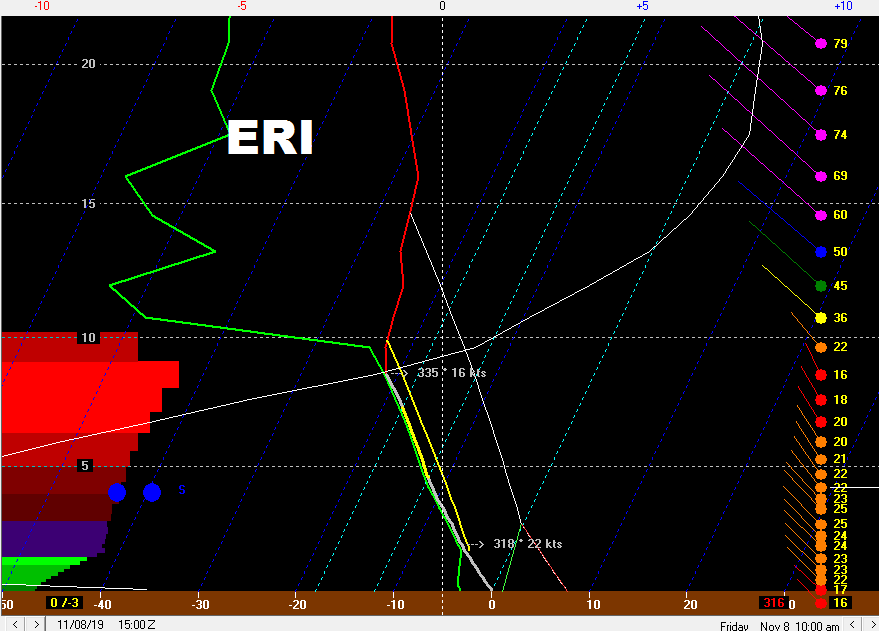
The Erie soundings are nuts, and last longer, well into Friday morning. There is a bit more shear, but that seems to be partially due to the model trying to simulate an intense lake effect band off of Lake Huron that is messing with the wind fields.
With our short fetch events, some sort of synoptic lift and/or upstream lake connections seem to be mandatory for good snow...
The Lake Huron connection should go into extreme SW NY or NW PA (the NAM does swing it west after this image). As usual with a NW flow, there will be some sort of Lake Superior/Michigan connection into the Cleveland area that can bring a narrow band or two of enhanced snow, especially in the hills. This connection likely dies down early Friday as the ridge builds in, though the Lake Huron one may last through a good portion of the day Friday.
The models do swing a weak shortwave through late evening into the overnight Thursday night. This would help for a few hours, though after this passes the ridging starts building in from the west and the environment becomes less conducive in NE Ohio (again though, downwind of Lake Huron will be conducive into a good chunk of Friday).
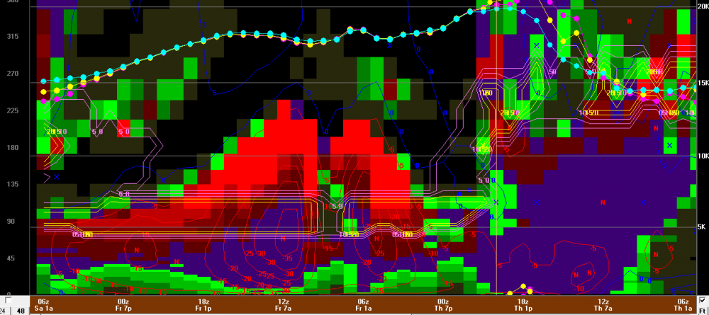
The above image is the NAM BUFKIT "overview" for Erie...the red contours are omega, greater than -15 is considered to be strong. The fill is RH (height is on the right), the snow growth zone is the pink/yellow outlined area that is sitting from 4-10k feet Thursday night through Friday, the low-level wind direction is plotted by the dotted lines (direction in degrees on the left), and time is on the bottom (in Z time). A busy image. But, what it shows is a classic "cross hair" signature (strong lift in the snow growth zone) for about 12 hours late Thursday night into Friday, indicative of heavy snow potential, with the winds only shifting slowly...moisture depth doesn't really decrease until Friday evening. It is really hard not to get warning criteria snowfall with this type of signature.
My overall guess for NE Ohio is 1-3" for most areas (perhaps little to none right along the lake) from Lorain and Medina Counties points east, even as far south as Akron/Canton and Youngstown. Short duration, short fetch events usually underwhelm, though with a NW flow many could see that light accumulation of snow. If the upstream connection parks in the hills south or east of Cleveland for several hours late Thursday night into Friday morning someone could see locally several inches, but I think that's the exception and most see an inch or two.
For NW PA this seems like a very favorable setup, though whether or not the band slowly moves around or sits somewhere may determine how high the totals get. I think a widespread 3-6" in interior NW PA (and extreme SW NY) is a decent bet, but locally up to or over a foot if the band off of Lake Huron is organized enough. The lakeshore will see less, but under the Lake Huron band can accumulate decently.
Let's see how this trends over the next couple days...and probably more chances coming up with even colder air next week. I'm in NE Ohio for a few days around Thanksgiving, let's not freeze the lake before then!
-
2
-


Northern Ohio Obs/Discussion Part 2
in Lakes/Ohio Valley
Posted
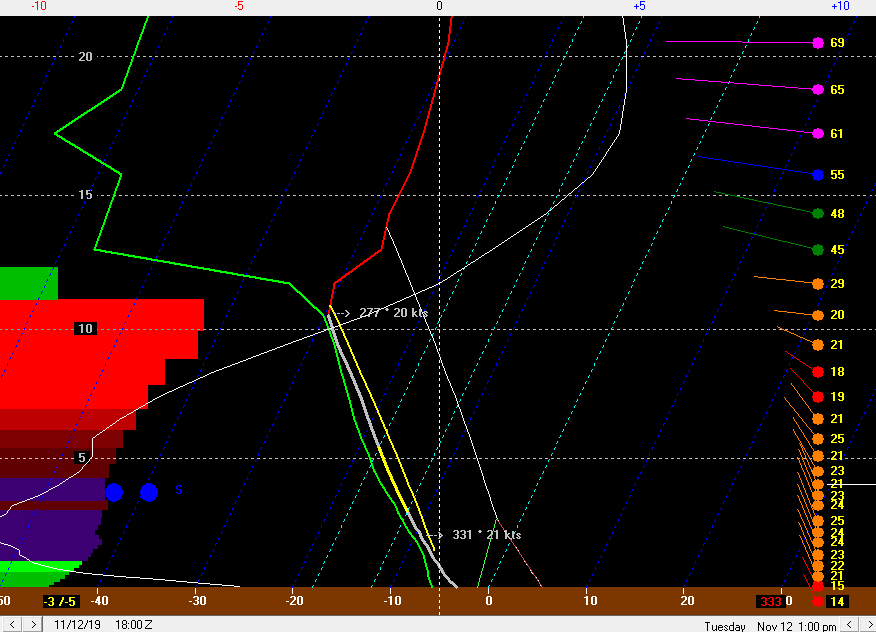
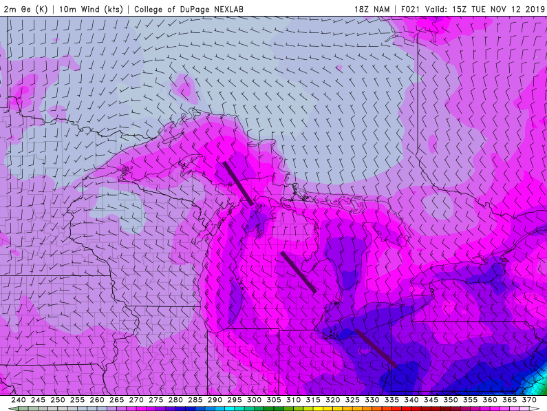
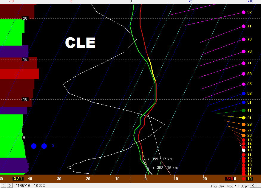
Yeah totally agree with you about the time of year limiting organization during the day. The winds have a southerly component at MFD, CAK and YNG and have been W or WNW along the lake all day. Winds have recently gone WSW at Akron and Ravenna and are more W along the lake, so we may be seeing that trough that's been inland either weaken or shift closer to the lake. You are right that the troughs hug the lakeshore more when the temperature difference between the lake and air is greater.
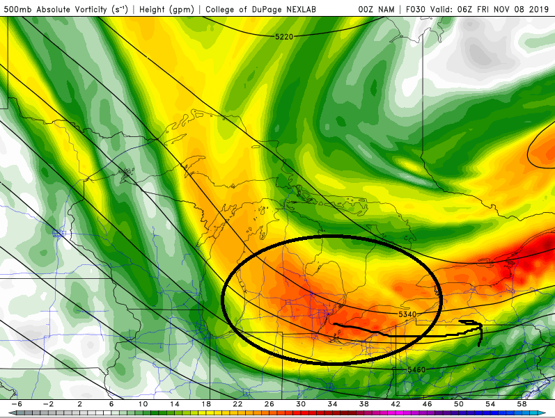
I feel pretty good about a band getting going later tonight east of Cleveland once we lose the diurnal influence and as the surface trough to the south either weakens or more definitively shifts north ahead of the second vort max that moves through early tomorrow...we'll see how far north that band ends up, and we'll see if we can get any organization over the next few hours before the first vort max moves through...that's where my skepticism/uncertainty is this evening. I think the best snow of the event may ultimately be tomorrow night into early Saturday with the better synoptic support and more WNW flow, making it more widespread too. The winds also weaken to more normal levels tomorrow through Saturday which will help any LES in that period.
Edit: Will tack on what I posted on FB this afternoon...still mainly on track overall after last night/this morning, just removing the snow that fell last night from the board.